AD Wash Gap Picture of the Week

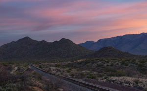
This month’s photo topic is Castle Hot Springs Road—part of my long-term project of getting off the highways to explore Arizona’s back roads. My only restriction is that the roads are accessible by regular passenger cars. That’s because I don’t want to buy some dune buggy for the project (Actual Read: Queen Anne won’t let me buy one).

Since I live on its west, Castle Hot Springs Road starts in Morristown at its junction with U.S. Highway 60—Grand Avenue. It loops northeast from Arizona State Route 74—which we always called Carefree Highway, but I see that it’s officially listed as Morristown-New River Highway—past the Wickenburg Mountains into the Buckhorn Range before it returns to SR 74 via the bed of Castle Creek through the Hieroglyphic Mountains. Its length is less than thirty-five miles, and you can use a pick-up truck because most of it is well-graded and broad. Its roughest section is on the east side, the several miles between Lake Pleasant and the resort, because it travels in the creek bottom. So, if you want to drive your Lamborghini to the Castle Hot Springs resort, take the clockwise direction from Morristown.

As I’ve said through the years,  people build highways from roads, roads on trails, and trails from paths, so you shouldn’t be surprised that some of the Castle Hot Springs Road originated from the Wickenburg stagecoach route. “Why travel through the mountains when there’s a straight shot across the desert floor?” you may ask. Remember, stages needed water for both passengers and horses. The trip took all day at best. On the west side, some parts of the original stagecoach road remain, and you can drive them, but you need an ATV or Jeep for that.

AD Wash Gap
AD Wash Gap–The AD Wash drains the local mountain and runs by the road before turning into a narrow canyon and eventually becoming part of Castle Springs. You get a peek of the Bradshaw Mountains in the distance in the gap.

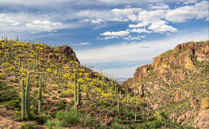
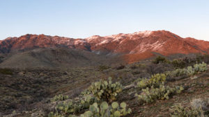
This week’s image comes from the road’s west section, a mile up the road from last week’s photo. On the north side of the mountain seen in that photo, Rincon Spring feeds a runoff called AD Wash—there’s no reference to what the name means, even in my trusty Arizona Place Names. The wash drains the local mountain and feeds the Layton tank before it turns and flows through a canyon between the hills. On the other side, AD Wash drops a couple hundred feet into Castle Creek.

When I shot this photo, I wanted to capture the saguaro grove against the canyon’s jagged edges in the late afternoon light. When I saw it on my computer, I was pleased with the paloverde in bloom and the blue streak running through the cloudy sky. For those unfamiliar with our Sonoran Desert, the saguaros in this photo range from 40 to 60 feet tall, and that should help set a sense of scale to what you’re viewing.

You can see a larger version of AD Wash Gap on its Web Page by clicking here. Be sure to return next week when we see another beautiful stop I made on my Castle Hot Spring Road outing.

Until next time — jw

Sunrise on Track Picture of the Week

There are only a half-dozen places Queen Anne, and I frequent in our home town of Congress. There’s Nichol’s West—our favorite local restaurant, the Post Office, the clinic, the Kwikie Mart, and the Dollar Store. Oh, I forgot the dump. For anything else, we have to drive into town or—shudder—the big city. Half of those in-town destinations are on the west side of the railroad crossing, which never has a train—most of the time.

I wrote in a newsletter about our train when we first moved here. This section of track is called the Pea Vine Grade that follows Highway 60 out of Sun City till Wickenburg then continues north to Prescott and Ash Fork. The name is descriptive of the twists along the route.

The tracks aren’t busy like the southern route in Yuma, or the north through Flagstaff. This route isn’t bustling and only has four to six passing trains each day. They’re not on any schedule that I can discern and you don’t hear them go by as much as you feel their bass vibrations, especially the ones coming up the grade. The five engines work hard dragging loaded freight cars up the hill, while the ones headed south sound like a wooden roll-a-coaster as they effortlessly roll downhill. Their horns only blare in Wickenburg and the Congress crossings. That’s too far away to hear from the house unless we’re sitting on the back porch and there’s a north breeze coming off the mountains, but even that’s so faint that it’s like a scene from a Steinbeck novel.

Sunrise on Track
Sunrise on Track – Dawn breaks with a red sky over the railroad tracks heading north from Congress Junction.

This week’s featured image turned out completely different from how I originally visualized it. I wanted to capture this shot with a train in it. The tracks come into Congress Junction from Hillside through the valley between the Date Creek Range and the Weaver Mountains. On most mornings, there’s an early southbound train. We’ve seen it while we’re out for our morning walks. To further set the scene, the Date Creek Range foothills at the crossing are prettiest at sunrise. The rest of the day, they’re flat and dull. So that’s what I had in my mind when I drove there in the dark.

I previously scouted out a lovely spot overlooking the tracks, and I set up my camera and waited for the characters to arrive. As the eastern sky got brighter, the clouds overhead turned red, and I thought, “Ooo shiny.” I fired off a couple of frames. As I waited, the fast-moving clouds moved east and began to block the sunrise removing any drama from my scene. Besides, no trains showed up. Disappointed, I packed up and drove around town looking for other subjects to shoot.

When I got home and reviewed my images, this was the shot that impressed me the most. Even without a train, the tracks are a leading line that moves your eye to the foothills.  The light bouncing from the clouds tints the scene pink, and that light softly brings out the mountain’s cone shape. There is a feeling of tranquility in this shot. It’s a moment of quiet and calm.

You can see a larger version of Sunrise on Track on its Web Page by clicking here. I hope you enjoy viewing this week’s post and next week; we’ll show another featured image from Congress.

Until next time — jw

Rock Frog Picture of the Week

Frog Rock
Frog Rock—The pile of boulders painted to resemble a frog has been a Congress landmark since 1928.

Our adopted town of Congress is a quiet retirement community these days, but it wasn’t always this sleepy. Like most of the old mining towns in Arizona, Congress was a bustling hive of activity as long as gold poured out of the ground. At its peak, the town had more people than a dusty farming village called Phoenix. But when the gold ran out, so did the reason to stick around. The land here is too rocky to farm, and there isn’t much to see—unless you’re a fan of large green amphibians.

Yes, Frog Rock puts Congress on the map. It’s not just any pile of boulders; it’s a pile of boulders that has been painted to look like a giant frog since 1928. I like to imagine that this oddball landmark sprang from the mind of Sarah Perkins, a homesteader’s wife who was bored out of her mind.

Picture a sweltering summer afternoon in 1928. Sarah is rocking on her front porch, the oppressive heat pressing down like a wet blanket. She’s sipping lukewarm lemonade and staring at the same pile of rocks she’s stared at every day for the last decade. Across the road runs US89, the main highway through town—a lifeline of commerce and travel. “Lester,” she says, her voice dripping with determination, “next time you’re in town, bring me some green paint.”

Lester, who’d been married long enough to know better than to question Sarah’s whims, nodded without so much as a grunt of inquiry. Weeks later, when he returned from Wickenburg with supplies in their rickety Model A pickup, Sarah found two cans of green paint and three sturdy brushes buried among the flour and beans.

The following day, before the heat became unbearable, Sarah gathered her sons and marched them across the road to the pile of boulders. With the determination of Michelangelo tackling the Sistine Chapel, they slapped on layer after layer of green paint. By noon, the Perkins family had created a masterpiece: a giant rock frog that gazed serenely at passing Model Ts.

Over the years, Frog Rock has become Congress’s pride and joy, our version of the world’s largest ball of twine or the giant ketchup bottle. Sure, it’s kitschy, but it’s our kitschy. When the paint fades, a self-appointed committee—armed with more enthusiasm than skill—ensures Frog Rock gets a fresh coat. On their last go-round, they even added spots to its back for extra flair.

Today, that highway is known as Arizona State Route 89, a quieter and more scenic version of its old self. Locals call it The Lost 89, a stretch of road that seems to have slipped out of time. Frog Rock has kept watch over it all—through the rise and fall of mining, the rerouting of highways, and the inevitable march of progress.

When I decided to photograph Frog Rock, I wanted to capture more than just the green paint job. I wanted to show how the massive granite boulder fits into its rugged desert surroundings, so I framed it with other rocks in the foreground. The result is a tribute to Sarah’s imagination and Congress’s ability to find joy in the simple things.

If you’re ever passing through town, stop by and say hello to Frog Rock. Don’t be surprised if you feel inspired to grab a brush and add your artistic touch. After all, in Congress, anything is possible—even turning a pile of rocks into a legacy.

Until next time — jw

Mobil Antlers Picture of the Week

A long time before we moved here, I remember driving through our little hamlet and noticing the old buildings in town. Queen Anne and I were traveling to visit my folks in Kingman, and after leaving Wickenburg, traffic stopped. Thinking it must be a result of an accident, I said to Anne, “We can detour around it by going to Congress.” It was ten miles out-of-the-way, but at least we’d be moving. It was when we reached the village that I saw the structures and said to her, “That’s so cool. I don’t remember this being a ghost town. I’ll have to come back and photograph it, someday.” (As an aside, my detour didn’t work because the accident was further north on US 93. We finally drove over to the river and took US 95, which put us several hours behind.)

There’s a reason why I didn’t remember those old buildings even though I had gone that way several times before. They weren’t there. After moving to Congress, that someday that I had set aside to photograph Congress’s historic district finally came. When I did, it disappointed me to learn that they’re a fake, like a back-lot movie set. The buildings are empty shells apparently used to display someone’s antique sign collection, but I don’t know why. It’s like someone threw up some structures as a tourist attraction and then quit before finishing.

The area of town at the  AZ 89 and AZ 71 junction isn’t the historic part of Congress. It used to be called Congress Junction or Congress Depot. The historical part of town was up Ghost Town Road near the mine. In this Wikipedia article, there’s a 1914 photograph that shows how it was. When the mine closed in the 1930s, the town moved to today’s location—lock, stock, and barrel. All of the buildings in the photo are gone. The land was scraped clean, including the mine structures. The only thing remaining is the old cemetery and a shed for Stephan—the mine’s caretaker.

Wouldn’t it be nice if someone bought and moved these buildings along the railroad tracks from old town? I don’t know, because there’s nothing to explain their existence. The only remaining business there is someone selling landscape rocks. Maybe you know the story and can share it with us, or perhaps, when I get a ’round-to-it,’ I’ll investigate and post an update.

Mobil Antlers
Mobil Antlers – An antique Mobil Oil flying horse is displayed over a pair of antlers at Congress’s fake garage.

I’ve pretty much ignored this part of town for the past three years, but since we’re featuring Congress during March, I wanted to show you what always catches my eye as I drive by them. It’s the Mobil Oil red flying horse sign. I’d like to have something like it to hang on the gable over my garage door—perhaps a Ferrari, Porsche, or one from Sunoco. To be accurate, however, my sign would be for beat-up Chevy station wagons.

In this week’s featured picture that I call Mobil Antlers, a set of antlers upstage the flying horse, so I concocted a fantastic story about it. It represents a tale about a red horse that soars high in the sky. He spots his prey in the meadow below—a handsome buck. The horse swoops in for the kill, and there’s a mighty struggle with the deer attempting to gore the soft underbelly of its attacker. Red-horse prevails and devours Bambi except for the antlers because they’re indigestible. Then I thought, nah—I’m not going to say that—it’s just too bizarre, and people will think I’m weird.

You can see a larger version of Mobil Antlers on its Web Page by clicking here. I hope you enjoy viewing this week’s image and come back next week when we’ll talk more about Congress.

Until next time — jw

Weaver Snow Picture of the Week

The weather here in Congress has been variable. I remember writing last year about the lack of rain, and we haven’t had that this year. It seemed like a new front moved through each week with more precipitation. The winter’s highlight, however, was last week’s snowstorm. There was enough of the white stuff covering our yard that we could measure it with a ruler (inch and a half). We’ve woken to frost and snow before, but this time it came down in the afternoon with temperatures well above freezing. Snow covered the surrounding mountains for days, and it looked more like Colorado than the desert.

During this time, I was trying to find a place for this month’s images, and I decided to stay at home this month and feature Congress. It’s been a while since we’ve done that, and besides, I need to cut down on my gas bill anyway.

Weaver Snow
Weaver Snow – Traces of snow remain on Weaver Peak following a winter storm.

This week’s featured image helped me decide to stay local. I wanted to show you how pretty the snow was on Weaver Peak, so for days, I waited for the sky to settle so I could shoot the scene without slogging through mud. Three days passed before those conditions were met and I was able to capture this image. I waited for the last rays of the sun, so that gives it that red glow. I call this image Weaver Snow, and I hope you enjoy it. For me, it shows one of the reasons that Queen Anne and I moved to the sticks.

You can see a larger version of Weaver Snow on its Web Page by clicking here. I hope you enjoy viewing this week’s post and next week; we’ll show another featured image from Congress.

Until next time — jw