Perry Mesa Needle Picture of the Week

Perry Mesa Needle
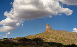
Perry Mesa Needle – This needle is at the edge of Perry Mesa above Black Canyon City. It’s new to me because it’s hidden from the freeway.

Phoenix only has two interstates that will get you the hell out of Dodge; Interstate 10 which either takes you west to California or east to everywhere else, and Interstate 17 going north. Driving I-10 in either direction always seems like a dreary, endless drive through the desert, while I associate I-17 with good times, like playing in the snow or—during summer—just escaping the heat. I think it’s because of all the different climate zones it goes through, like the desert, grasslands, riparian, and alpine forests.

The first change that you come to when heading north is the grade at Black Canyon City. It’s an abrupt transition from the Sonoran Desert to riparian grassland—saguaros are at the bottom, and they’re not at the top. It freezes more often at higher elevations, and the giant cacti can’t tolerate it. Black Canyon City is distinguished by being the northern edge of the Sonoran Desert; I know that because it says so on their welcome sign.

Most Phoenicians consider Black Canyon City a suburb populated with free-spirited residents. It’s the bottleneck on the highway where heavily ladened trucks insist on passing one another up the steep grade, or traffic is backed up to Prescott because a crash closed the freeway and there’s no other way around. During heavy rain, the community makes the news because the Agua Fria River floods and people get trapped in their homes or cars. If you do stop in town, it’s to get a slice of pie at its famous restaurant. I wouldn’t be surprised if most Phoenicians didn’t know Black Canyon was in a different county—Yavapai. I know that I didn’t, and that’s why I chose Black Canyon City as my place to look for October’s art.

I saw the subject of this week’s photo as I was driving around town. I-17 divides Black Canyon City in two. The business district is on the freeway’s west side while on the east is mostly residential and a few light industries. The needle can be seen on the east side but not from the interstate. That’s why I didn’t know it was there. It’s like a smaller version of Weaver’s Needle in the Superstitions, but as much as I searched, I couldn’t find its name. There was nothing on my topographic maps, highway maps, the Gazetteer or the city’s website. I saw this neat YouTube drone video, but it doesn’t list a name either. It’s on the southwest corner of Perry Mesa (sounds like an excellent name for a lawyer, doesn’t it?) where Squaw Creek runs into the Agua Fria River, so I used that moniker for the photo’s name—Perry Mesa Needle.

In this image, I like the way the low clouds and their shadow frame the subject. The grove of saguaro midway up adds scale to the outcrop. Finally, the recent rains cleared the air and gave me a deep blue sky making the puffy white clouds seem to pop in 3D. As was the case with the Jerome Hollyhocks a couple of months ago, if you know this needle’s name, please email me.

You can see a larger version of Perry Mesa Needle on its Web Page by clicking here. I hope you enjoy viewing this week’s post and come back next week when we’ll feature more from Black Canyon City.

Until next time — jw

Prickly Juniper Picture of the Week

In a place like Sedona, with its canyons and red-rock buttes, it’s easy to get overwhelmed by abundant beauty. I can imagine a project where I simply recorded a catalog of the natural formations along Oak Creek, but that would make for a boring story. A good story changes pace and adds contrast. That’s why, as I scurry about hither and yon at a new site, I keep my eyes open for interesting things below my nose.

Prickly Juniper
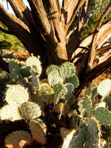
Prickly Juniper – A prickly pear cactus grows in the sun beneath a dead juniper tree in Sedona Arizona.

This week’s featured image—called Prickly Juniper—is an example of looking for intimate subjects amidst spectacular scenery. I saw this prickly pear along the trail that I wrote about last week. If it were on its own, I probably would have ignored it, but it nestled under the bare branches of a dead juniper tree and together they caught my attention. I liked the light against the dark, the living against the dead, and the prickly pear’s circular pads against the tree’s linear branches. The late afternoon sun was showing off the tree’s texture and the cactus’ lethal thorns. I took a couple of variations of this image and I felt this version was the best.

You can see a larger version of Prickly Juniper on its Web Page by clicking here. I hope you enjoy viewing this week’s post and come back next week when we’ll present another featured image from Sedona.

Until next time — jw

Capitol Butte Picture of the Week

Sedona is the most romantic town in Arizona. Don’t believe me? Just watch the Social Sound Off question on the evening news. Each evening, they ask a trivia question about Arizona. The news people get lists from internet sites or magazines about the most popular places for something or another. If the question is about tourism or travel, the answer is either the Grand Canyon or Sedona. The romance question was a recent topic and—you guessed it—Sedona was the answer. For more evidence linking the Red Rock Country to lovers, try booking a hotel room in Sedona for Valentine’s Day. The closest room you’re likely to find is in Eloy.

Capitol Butte
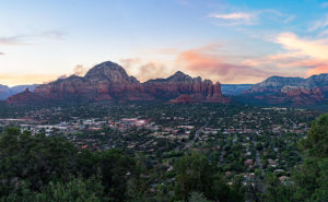
Capitol Butte – a tribe of millionaire-Bedouins have camped in their shabby-chic tents for the night among the red rocks of Sedona.

It’s been over a decade since I last visited Sedona and all of the changes shocked me. Gone is the quiet dusty little creek-side town nestled in Oak Creek Canyon. Back then, there were the usual galleries, jewelry, and souvenir stores in the village, but now it looks like Scottsdale or Newport Beach. The single traffic light has been replaced with dozens of traffic circles. With its limited space and water supply, Sedona has always been the place we loved to death and surely it’s now ready for hospice care.

As a photographer, I’ve been frustrated when shooting there. When you’re trying to get a shot that tells the town’s story, you’re thinking about red rocks, Oak Creek, and the old sycamore trees. You can get that shot at Red Rock Crossing State Park and virtually every photographer has it in his or her portfolio. On this visit, I wanted something different to photograph, so I did a bit of exploring. I hiked a short trail in Boynton Canyon and I ended my day on top of Airport Mesa.

I hung around after sunset until the crowd left—there’s a dedicated parking lot for this viewpoint and people pay three-bucks a car, who knew? I wanted the town dark but have Capitol Butte lit with the soft residual light in the western sky, so I waited until the town lights began to come on.

I believe that I got a different interpretation of this familiar view. I called this image Capitol Butte after the red-rock feature towering over the village. It shows how packed the dwellings are between the rock formations that draw so many people from around the world. I like the contrast of the orderly north-south-east-west streets within a so-called nature setting. When I look at this image, I see a tribe of millionaire-Bedouins camped for the night around the waterhole.

You can see a larger version of Capitol Butte on its Web Page by clicking here. I hope you enjoy viewing this week’s post and come back next week when we’ll show more from Sedona.

Until next time — jw

Kodachrome Pipe Picture of the Week

When exploring Utah’s State Route 12, you really must take time for a side trip to Utah’s Kodachrome Basin State Park—20 miles east of the Bryce Canyon entrance road. Kodachrome Road runs among the cattle pastures from Cannonville to where the pavement ends and the park entrance. There is a small entry fee which you pay at the visitor’s center. If you’re camping, the park’s sites are coveted and the restrooms have flush toilets, hot and cold water, and they’re heated in winter.

Kodachrome Pipe
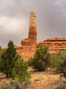
Kodachrome Pipe – Sand pipes are unique to Kodachrome Basin State Park and there are over sixty of them to photograph. All you have to do is find them all.

I’ve written about Kodachrome Basin in my newsletters before because it’s a favorite destination of ours. Located on the valley floor below Bryce Canyon, the elevation is three-thousand feet lower, so in winter it doesn’t have a bitter cold you’ll find back up on the hill. But it also means that summers are warmer and the temperature can crack the century mark.

Surrounding the park are tri-colored cliffs—red, white, and gray—the same colors that make up the middle three stairs of the Escalante Grand Staircase. Unique to Kodachrome Basin is its sand pipes. It’s thought that millions of years ago, this area was like Yellowstone with geysers and hot springs and as the basin sank into a shallow sea it was covered with layers of sand. The geyser’s immense pressure forced fractures in the hardening sandstone and drilled vents. Then, as the plateau rose, rivers cut into the soft sandstone leaving the hard stone pipes behind. There are over sixty pipes in the park for you to find and photograph (hmm, sounds like a book idea). The one in this month’s featured image is on a shelf overlooking the campground like a trophy on display.

Our Kodachrome visit on this trip was by accident. Each day, afternoon thunderstorms kept us off the dirt roads we’d planned to explore. Because the park roads are paved, we changed plans and wasted some electrons photographing Kodachrome Basin in the rain. My first observation is that the colors are duller when they’re wet. My second was that the trails were muddy and the washes were running so we stayed near the roads. I’ve photographed this pipe before but wasn’t happy with the result. This time, I think I have an interesting shot for you. I call this image Kodachrome Pipe, but I may have to begin numbering them in the future. Because it was so overcast, I wasn’t aware that I was shooting directly at the sun—the bright area in the photograph’s sky. While I processed the image, I tried forcing the clouds to be darker, and when I did, the sun’s disk began to show including a rainbow ring around it. The results didn’t look natural, so I dialed it back to this version.

You can see a larger version of Kodachrome Pipe on its Web Page by clicking here. I hope you enjoy viewing this week’s post and come back next week—a new month—when we’ll start a new series from a different place.

Until next time — jw

Teasdale Cock’s Comb Picture of the Week

The geological roller coaster ride that is Utah State Route 12 ends on its east side in Torrey, Utah, and as the road descends Boulder Mountain’s north slope into town, there is a jagged uplift called the Cock’s Comb (Google Earth spelling) that you can get to via the side road to Teasdale. From Highway 12, it looks like a miter—a bishop’s hat, but when viewed from the south it’s a quarter-mile long section of crust ripped from the earth’s surface and stood on end. When I did some research for this post, I found that there’s something interesting about the Cock’s Comb besides being a big old hunk of rock. There are a road and trail—Fish Creek Cove—that lead to a very large panel of Fremont Era Rock Art. I wish I knew about that while we were shooting, but now I have a reason to go back.

Teasdale Cock's Comb
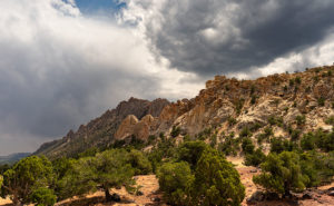
Teasdale Cock’s Comb-A quarter-mile uplift found outside of Teasdale, Utah is threatened by afternoon thunderstorms.

Of all the shots I took at the site, I selected this one to be this week’s featured image because of the layers. The thunderstorm was moving north from Boulder Mountain rapidly and the main part of the rift is in shade, but the smaller ridge is still in the sun. I also thought the clump of juniper trees in the foreground added to the sense of depth. I call this image Teasdale Cock’s Comb.

You can see a larger version of Teasdale Cock’s Comb on its Web Page by clicking here. I hope you enjoy viewing this week’s post and come back next week when we show more of the dramatic landscapes along Utah’s State Route 12.

Until next time — jw