Cedar Breaks National Monument Utah Photo Shoot

Cedar Breaks Amphitheater - Cedar Breaks is a five-mile amphitheater that looks like someone took an ice cream scoop to it and left behind the candy toppings. The distant peak is Brian Head at over 11,000', where the ski resort is located.
Cedar Breaks Amphitheater – Cedar Breaks is a five-mile amphitheater that looks like someone took an ice cream scoop to it and left the candy toppings. The distant peak is Brian Head at over 11,000′, where the ski resort is located.

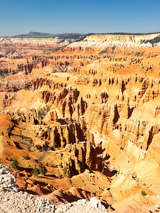
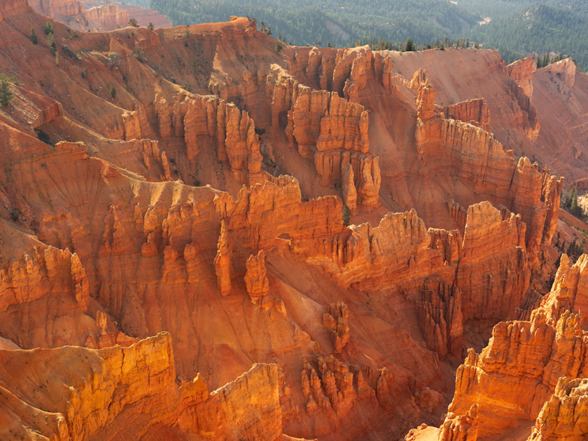
Yesterday could have been the perfect day to visit Cedar Breaks, the mini version of Bryce Canyon high on the eastern edge of the Markagunt Plateau in southern Utah. The muggy weather that had hung around all weekend moved out and it was dry and sunny with a light breeze from the west. As we entered the park the car’s temperature indicator said it was 68° outside. Conditions couldn’t have been better for an afternoon of hiking and picture-taking.

It wasn’t this nice the first time we visited Cedar Breaks. That was Memorial Day weekend in 2004. The Queen and I decided to get out-of-town to escape the 115° weekend. We had tossed the camping gear into the truck and left before dawn dressed in shorts and tee shirts. We drove straight through only stopping at the Flagstaff Mickey D’s for an egg-a-muffin. That truck didn’t have an outside temperature gauge and it barely made it up the 12% grade. We still had the air-conditioning on when we stopped in the parking lot. It was a sunny afternoon, but when we opened the doors, a blast of Arctic air greeted us and chilled us to our bones. We scrambled to find our jackets. At 10,300 feet, Cedar Breaks can be hostile.

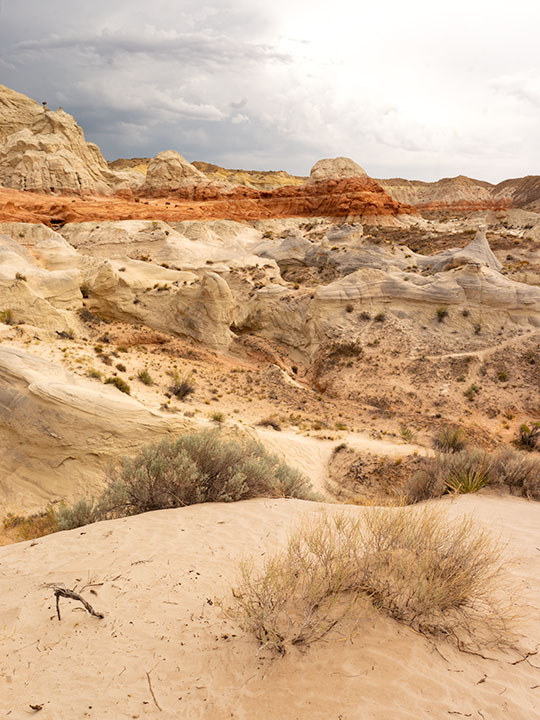
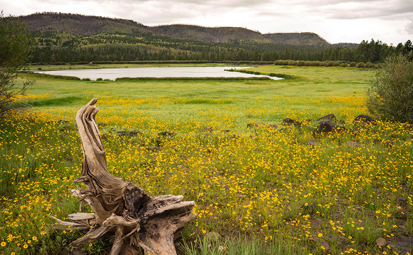
Tee shirts and shorts were the perfect uniforms yesterday. That wasn’t a problem. The issue that I had was in the air. Up here, it’s normally clear and pristine, protected by its remoteness, but because somebody’s trying to burn down California, the air was filled with smoke that traveled across Nevada. That smoke-filled air is not conducive for taking detailed landscape panoramas. I had to change my mindset and look for more intimate images.

Bristlecone Pine
Bristlecone Pine – Probably over two thousand years old, bristlecones survive by shutting down damaged parts and only supplying new growth with nutrients.

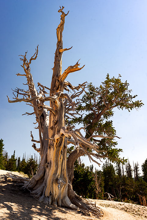
From the visitor’s center, there’s a short one-mile hike to Spectra Point—an overlook that has a grove of large Bristlecone Pine trees. I’ve always admired these Methuselah trees for how they live for thousands of years in places where nothing else will grow. I had heard about them on my last trip, but it was spring thaw with snow covering parts of the trail and the rest being a muddy bog. That wasn’t an excuse today, so I put on my new camera backpack and balanced the tripod on my shoulder and set off to conquer nature.

Fins, hoodoos, and arches.
Fins, hoodoos, and arches – As the soft sandstone erodes it breaks down into long structures called fins. As the fins erode they leave individual spires called hoodoos. During that process, the bottom of the fin may fail and collapse leaving a window or arch. There are examples of all three in this photo. Can you spot the arch?

The trail actually leads to two overlooks, the second one being Ramparts. As I started skipping along I considered going the extra mile—as they say. It looked doable on the map because the parking lot is 10,300′ and Spectra point is 10,285′. A mere 15-foot drop—posh, child’s work. Ramparts, however, is 9,985′. I decided to see how I felt when I reached Spectra Point—after all, I have ridden a bike five miles every morning, so I’m buff … Right?

My skipping immediately ceased when I turned a corner and reached the base of a 300′ hill that’s not on the map. You can guess what my decision was already. I can walk three miles in an hour at home, but in the thin air, my trip took 45 minutes. I spent an hour shooting trees and views along the rim before heading back to Archie—our truck, where Anne was reading a book. You’d think she’d have carried the camera bag or a picnic basket or something. When I opened the back door in my sweat-soaked shirt and loaded the equipment while panting, all I got was, “How was your little hike dear?”

We spent today recuperating—she broke a nail—and I processed a couple of photos to show you. At dinner, we’ll decide where next to explore. We’ve concluded that the smoke has permeated Utah and we’ll just have to work around it, but we’re going to have fun even if it kills us.

Until next time — jw

Kanab Overnight 2018 Utah Photo Shoot

We stopped short of our target destination—Panguitch—by a hundred miles because I wanted to shoot along the lower Paria River. I was hoping to shoot a couple of areas that I previously visited bathed in a late afternoon sun. Instead, it rained. I captured some nice images anyway and Queen Anne followed me most of the way up the trail—including a bit of the climb. That was a miracle unto itself.

Dune at the Toadstools
Dune at the Toadstools – This is one of the images taken at the Toadstool stop along US 89. It was the first time I hiked up to them. To her credit, Anne followed me most of the way.

Our temporary site is in Kanab and the RV Park we originally stayed in during our Alaska adventure. New owners bought the place a couple of years ago and have made improvements. I’d have to rate it as one of my favorites—although truck traffic still starts early. Last night we enjoyed a fine meal at the Rocking V Cafe. It’s the fourth time we’ve stopped there without disappointment. Anne was perturbed that they didn’t serve their macaroni and cheese for dinner. She had been going on about it all day and nearly beat up the poor waitress when they wouldn’t make some especially for her. Instead, Anne wound up enjoying the curry dish that she ordered.

We’re packing up this morning and making the pull up to Panguitch. It’s another thousand feet higher and ten degrees cooler so that suits Anne’s prerequisite. It’s also centrally located to the areas that I want to shoot. We will be pulling The Ritz for a couple of hours so we’re not in a rush this morning. As a matter of fact, it just turned 8 am and I rousted her highness from the sack. If she stays in character, she’ll dawdle all morning so that we’ll have to stop at the Rocking V for a lunch of Mac ‘n cheese.

Until next time — jw

The Great Springerville Mexican Food Shoot-out

We we’re traveling to a new town, one of the tools we rely on is the Web Site, Trip Advisor. You can search for things to do, hotels and restaurants. It’s like Yelp. The restaurant reviews are pretty helpful, but you have to watch out for people who have an axe to grind. I’ve even written a few reviews. Before our trip to Springerville, one of my chores was to check the restaurant reviews. When I did, I found two of the top-ten restaurants served Mexican food (the 11th ranked restaurant was McDonald’s). One of them is at the top of the list while the other is tenth.

My all time favorite joint for south of the border food is family owned and they have a couple of places in the Phoenix, and another in Springerville. I love their food because it’s New Mexican style. You may have already guessed that I’m talking about Los Dos Molinos. Their main location is on Central Avenue south of Baseline; in the old Tom Mix house (the link is for those who have no idea who Tom Mix was). The food is spicy hot and the Margaritas will knock you back on your spurs. A shock to me was that it is the underdog on Trip Advisor’s list.

The highest ranked place in town is Booga Red’s, and they also serve American and Southwestern (?) style meals. Cars are always parked in front and they’re open for breakfast. The style of their food is Nortino. It’s milder; like you’d expect at Macayo’s.

For the shootout, The Queen and I ate dinner at both restaurants and tried to order the same menu items — which was impossible. The judges are Queen Anne and me, we get one vote each. The common items that we judged are the chips and salsa, the margaritas, a taco and a tamales. I’ll be talking about the other stuff we ordered. Are you ready … bring out the chips and salsa.

Trailer And Gardinias
The sights of Springerville. Vintage trailers as yard-art.

Chips and Salsa

This is the first impression that you get at any place that serves Mexican food. The worst that I ever had was in Salina, Kansas, where they didn’t have a clue, and served cinnamon bun bites instead. There is a big difference between tonight’s candidates.

At Los Dos, they serve red and green salsa. Of course, you don’t really eat it. You only hold the chip over your favorite color and let it absorb the fumes. If you accidentally dip your chip into the salsa, carefully shake it off, and immediately order a glass of milk. Their chips are thicker and darker, but they need to be. If they were thinner, they would instantaneously burst into flames. We didn’t finish the chips and salsa.

Booga Red’s chips are light and thin and taste good, but the salsa is a clone of Pace, the salsa that you buy in Safeway. There aren’t any chunks, not enough jalapeños and no cilantro. We ate all the salsa.

(Los Dos – 1, Booga Red’s – 1)

Trailer With Red Bike
Sights of Springerville. Trailer as yard-art.

Margarita’s

When you order a margarita at Los Dos, they ask you if you want a single, double or three shots of tequila. The mix is distinctly house made. Anne didn’t like it because it was sweet instead of tart, but that didn’t stop her from ordering a second.

I thought the Booga Red’s margarita was indistinguishable from the pre-mixed Costco bottles. The tequila was probably in there but it wasn’t up-front. I still ordered a second.

(Los Dos – 1, Booga Red’s – 1)

Trailer With Bunting
Views of Springerville. Trailers as yard-art.

Main

This is where it gets complicated. The nightly special at Los Dos Molinos was Posole which I am very fond of and rarely find on a menu, while Anne ordered a quesadillas at Booga Red’s, so there’s nothing to judge here. I must say that my soup lacked flavor. It needed more seasoning (not just chilies), it needed to simmer longer and it needed more of the ingredients that make up a great Posole, however the pork was fork-tender (as only Los Dos Molinos can do). My other complaint was that Mama’s Carnitas were not on the menu, and that is my favorite and why I go there. As for quesadillas, you can do those in the microwave in fifteen seconds.

(No Score)

Tacos and Tamales

OK, we’re down to the basics. At Los Dos, the tamales was everything you would expect. Course ground masa with a spicy pork filling and, in this case, topped with a red enchilada sauce. If the masa was made with blue corn, I would have died right on the spot. I tried to order a shredded beef taco, but Angelina insisted that I try the Carne Adovada — marinated pork — and I was glad. I can count on one hand the number of tacos that I’ve had better.

Booga Red’s shredded beef taco was very good, and I’d order it again. It was light on flavor but the shell was cooked properly and held up as you ate it. The tamales on the other hand was something I’ve never seen. The masa was light and airy, almost flour like, and it had whole kernels of corn mixed in?!? I ordered mine enchilada style with green chili on top. This close to New Mexico, I expected tears in my eyes, but instead it was a tasty chili gravy. It was good but bland, just like I like my Cream of Wheat.

(Los Dos – 1, Booga Red’s – 1)

Desert (this is actually cheating)

At Los Dos Molinos, Angelina makes her own Sangria, that’s a wine and fruit juice mix. It’s awful and most of us stopped drinking it in the sixties. However, after she makes the wine, she uses the smashed fruit to make an upside-down cake. It’s baked in a skillet like a normal pineapple one, only the fruit marinades the cake half-way through. I’ll be really honest here, pineapple upside-down cake is my favorite and I bake one each year for my birthday. This was better than anything I have ever made, and mine are damn good.

Booga Red’s — < the sound of crickets>.

(Los Dos 2, Booga Red’s – 0, but this doesn’t count)

If you’re keeping score, you’ve noticed that we have a tie. You can tell which of us enjoys a little adventure. Now, I regret to tell everyone that Anne thinks that the best tacos come from … Taco Bell. Because she obviously has no taste, she is disqualified from the judging panel. So, the winner is … whoever you like the most. If you like safe and tasty food, Booga Red’s is the place for you. We both enjoyed our meal there. If you’re one of Satin’s children, I recommend Los Dos Molinos, because it’s beyond the normal.

And now we return you to regularly scheduled programming.

Till then … jw

Greer

Over the 2011 Memorial Day weekend, a forest fire started in the mountains overlooking Springerville. They called it, The Wallow fire, the largest forest fire in Arizona’s history. Crews fought the blaze for over a month before containing it, but the fire did an enormous amount of damage and one of its victims was the little town of Greer. The reports that came over the TV news were not good. We feared that Greer had burnt to the ground.

Anne and I have a fond memory of the quaint town tucked into a White Mountain valley. When we decided to get married, she sold her Atlanta home and moved to Phoenix. She drove across the county alone, but I flew to Albuquerque and we made the rest of the trip together. Rather than take the Interstates, I thought it would be nice to show-off some of Arizona. We drove south along the Rio Grande to Socorro, and picked up U.S. Highway 60 so that we could enter Arizona the back way. If this seems familiar, it should. Our route took us past the Very Large Array, through Springerville, and we spent her first Arizona night in a Greer cabin. During the night, we had a late winter storm, and on the morning of April 15th, we found that it had snowed. Ironically, that delighted her. After she finished playing in the fresh snow, we scraped off her car and continued the trip to Phoenix.

Tunnel Lake
An old tree stump and wildflowers provide a foreground for Tunnel Lake in Greer.

Yesterday we drove up to Greer for lunch, expecting to see a barren  blackened valley. We didn’t find that. We saw the burn scar along the mountain ridge flanking the valley’s east side, but the valley floor seemed untouched. The Molly Butler Lodge was unchanged and even the Greer Peaks Lodge, reportedly damaged by the fire, had long been repaired and open for business. What had changed however, was the little town of quaint cabins has become a community of large expensive mansions that were second homes for the wealthy. With its proximity to the Sunrise Ski Resort, Greer was looking more like Vail, without the expensive downtown shops.

Cinder Hill Ranch
A barn at the base of a volcanic cinder cone on a rainy afternoon in Greer.

We stopped at the crowed Rendezvous Cafe and had lunch. The food was great and we took in all the kitsch cluttering the walls (why is that still a thing?). While we ate, we watched hummingbirds fight over the feeders outside. On the specials board, they had home-made cherry cobbler, so we couldn’t pass that up and added a dollop of ice cream. “That’s some mighty fine cherry pie, ma’am.”

Last Cast
A father and kids make one more cast before the rain starts on one of the Greer lakes.

After lunch, we vainly searched for our little cabin Perhaps it fell victim to the fire, or maybe they tore it down to make room for a McMansion. In either case, we couldn’t find it. After we gave up looking, we drove around taking pictures until a light rain started. It seemed like a good excuse to call it a day and head back to the trailer for an afternoon nap. We left Greer behind assured that it was fine and we’d visit again.

P.S. Since this is our last day in Springerville, we’ll be posting the results of “The Great Springerville Mexican Food Shootout” this afternoon. Stay tuned for that. For now, Queen Anne and I are busy watching the eclipse.

Till then … jw

These Aren’t Shade Trees

In the spring of 1959, my dad traded in his ’52 Ford Business Coupé for a brand new Ford station wagon. It was two-tone — white over red — with red vinyl seats, push button radio and 4-60 air conditioning — you’d roll all four windows down at 60 miles an hour for greatest effect. Neither my three sisters nor I had a clue why he bought the new car. His pride and joy was the ’56 Crown Victoria that was in the garage. We didn’t need a reason, and we didn’t care. It was new and shiny and had pretty wide white walls. As we found out later, he bought it so we could visit his uncle in California. The six of us were taking a two-week road trip from Pittsburgh to LA and back. We were the Griswolds prototype.

When my dad was behind the wheel, he focused on the destination. I don’t think the man would have stopped for a bathroom break had not one of us been whining from the back. We started out on Friday evening, and drove all night to Chicago, but not stopping until the next evening in Joplin. Mom may have done a stint, but we were asleep in the back.

We were on Route 66, The Mother Road. We didn’t appreciate its significance then, the TV show wouldn’t air for another year and we were too busy making truckers honk their air horns. My dad was relentless, he wouldn’t stop to see the Jackalope, the Thing, the Grand Canyon, or any of the other cool places that cost time and money. Can you imagine torturing kids like that? Signs along the road … “The Thing – 50 miles”, “The Thing – 10 miles”, 5, 4, 3, etc. At least he didn’t stop the car to kill us. Of course, that would have meant stopping the car.

Teepees
A pair of Chinle Shale formations showing the different colored layers of volcanic ash.

He did stop at one place — The Petrified Forest — he had to. The stupid road ran right through it. He said we could stop and go through the park and we were giddy. Finally, we’d see something and maybe get a break from the treeless desert we drove through. A forest, with trees; made from rocks … yeah! Imagine our shock when we saw all the rock-trees were knocked over. This wasn’t a respite from the desert, this was just more desert … with cool looking rocks. “There’s so many of them, can I take just one mom … huh? … huh? … Can I?” Even now, I sound so annoying, I want to slap myself.

Petrified Logs
The stops along the park road show off the park’s best. This is the Large Trees exhibit.

Within a month of our return from that vacation, my parents sold our Monroeville house and the second car. They got rid of most of our excess baggage and we moved to California. We settled into a Sylmar rental house so quickly that none of us kids missed a day of school. Although our family drove along Route 66 four more times, we never again stopped at the Petrified Forest. After I moved to Arizona decades later, I made two photography outings to the park on my own.

Blue Mesa
My favorite part of the park is Blue Mesa with its maze of Chinle Shale erosion.

Yesterday, I took Queen Anne to visit the park for her first visit. Despite what Google Maps says, it’s only an hour trip along U.S. Route 180. The road follows the Little Colorado as the river descends from the grass-covered Springerville Volcanic Fields, past the little town of Saint Johns where the cinder cones give way to dirty tan sandstone. The red silt river played hide and seek, only revealing itself when it passed under the empty highway. As the elevation continued to drop, the sandstone formed low tables and — where water eroded the softer underlying shale — large angular blocks broke off and slumped on the red soil below. Further along, I saw a bright white swell that I guessed was Chinle Shale and I knew we were almost there.

When we visit a national park, we head straight to the visitor center. That’s where you learn stuff … besides, I love those giant relief maps — which they didn’t have here. This time, we sat through the documentary film, browsed the museum exhibits, picked up some pamphlets, and bought two photo books before driving north along the road. As a photographer, I want to see the ‘long-shot’ first, so we slowly drove the road’s length. I made mental notes as we went, and tried to figure out how I’d shoot those images after the crowd thinned. After we turned around, we stopped at each pull-out, walked the trails, and photographed what we saw. As the day passed, I watched how the light and the sky changed as clouds formed over the White Mountains and the San Francisco Peaks before they drifted away in the invisible air stream.

along the bank of the Puerco River, a pueblo ruin
Along the bank of the Puerco River, a Pueblo ruin can be explored at leisure.

We discovered that the park isn’t just about petrified trees, it’s about layers. There are layers of soil and rocks, layers of flora and fauna, and layers of settlers and travelers for everyone to see in an open time capsule. As each rainy season washes away soil, more fossils are uncovered. There are fossils of ferns, grasses, lizards, crocodiles, toads, dinosaurs … and yes, trees. People before us settled this land, and they’ve left things behind for us to find. They left arrowheads, baskets, weaving, petroglyphs, and along the bank of the Puerco River, a pueblo ruin. Other people have traveled through the park. The Mogollon’s had trade routes to and from the Pueblos in New Mexico. In 1853, Lt. Amiel Weeks Whipple used those trails to survey the route now used by Burlington Northern Santa Fé Railroad. The tracks were a basis for U.S. Route 66 and now Interstate 40. These routes are layer upon layer of traders and countless migrants moving across the Colorado Plateau.

Route 66
To commemorate the famous highway, the park service placed a 1932 Studebaker shell at the place where the highway and park road crossed.

Even though the National Park’s mission is to preserve and protect natural history, I was pleasantly surprised to see a nod to history more recent. There’s a turn-out north of the Interstate 40 bridge marked by a rusty skeleton of a 1932 Studebaker on blocks. It’s the spot where Route 66 passed through the park. The pavement has returned to grass and sage, and only the telephone poles give away the road’s alignment. The road of my past. While I was photographing the scene, I swore I heard distant echoes of four kids in a red and white station wagon, begging dad to stop.

Till then … jw