Get Bent Picture of the Week

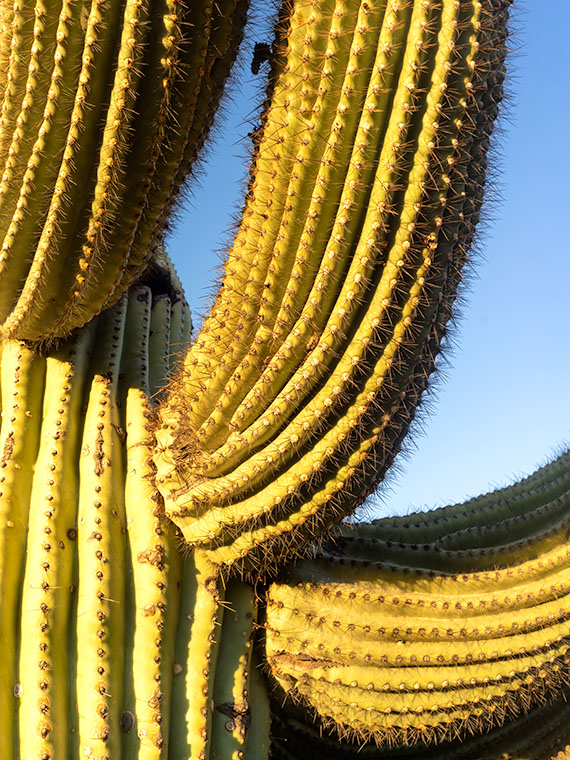
Not all saguaros are super-models. Like people, they come with all sorts of warts and scars. The Gila woodpeckers carve nests in them because inside the flesh, the summer daytime temperatures can be over thirty degrees cooler than outside. The cavities don’t cause harm to the saguaro, and squatters like hawks, owls, and other birds move in after the woodpeckers leave. The substantial threats to a saguaro’s life are from lightning, strong winds, stupid people, but the real culprit is frost.

On our imaginary day-trip around Saguaro National Park, we’ve left behind the visitor center, and we’re exploring the Bajada Wash Loop, which leads from the west side up toward the Tucson Mountains—the park’s backbone. In fact, these are the only roads into the interior. Countless trails crisscross the park, and they appear to be the preferred method of exploring the backcountry. I’ll leave that mode of transportation to people younger and more agile than me.

Get Bent - A frost damaged saguaro rises above a thicket of palo verde before the Tucson Mountains.
Get Bent – A frost-damaged saguaro rises above a thicket of palo verde before the Tucson Mountains.

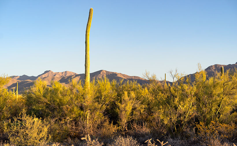
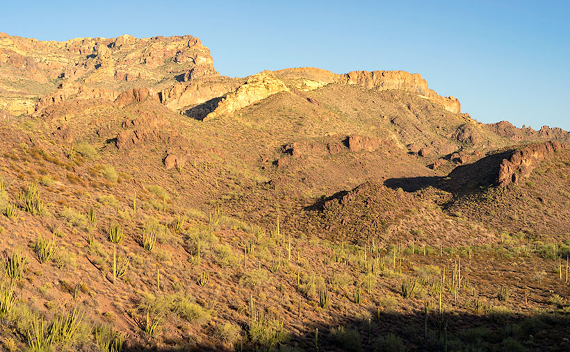
The afternoon was getting late when we reach the top of the loop. The shadows were already long as I looked for a shot of the range’s high peaks. I stopped the truck when I spotted an interesting cactus. It rose maybe thirty-feet above the top of a palo verde thicket, and it had a bent trunk. I guessed the deformity was the result of a freeze. It’s a young specimen—if you can consider thirty-years young—to have damage like this, but the Tucson Basin is a thousand-feet higher than Phoenix, and we were near the top of the loop, which is 500-600 feet above the city. That’s near the limits of the saguaro’s range because winter nights often get below freezing up here.

After I processed this shot and began pouring over area maps,  I realized that I also captured another landmark in it—actually two of them. To the saguaro’s left are two peaks on the horizon. The taller of them is Wasson Peak (4639′), and the other is Amole Peak (4386′). They are the two highest points within the park’s boundaries. So, this week you get a BOGO.

You can see a larger version of Get Bent on its Web Page by clicking here. Next week, our day in Saguaro National Park comes to an end, so be sure to come back and see what we found.

BTW: Queen Anne and I wish you a very safe and happy Thanksgiving. We’ll be spending the day at home enjoying store-bought leftovers. You know, the usual turkey, stuffing, mashed potatoes swimming in gravy, cranberry sauce molded in the shape of a can, and buttermilk pie topped with fruit and whipped cream. I’ll see you next week if I can get up from the couch.

Until next time — jw

Arm Pits Picture of the Week

When we visit national parks, Queen Anne and I like to spend time at the visitor’s center. We study the 3D display map and look through all the books. It gives us an idea of what to expect. Unfortunately, one of the regrettable effects that COVID 19 has brought is that the centers are closed. Even so, we stopped at the one in Saguaro National Park because they leave literature outside for crazy folks like us. That’s where the story of this week’s picture begins.

After picking up a map, I wandered the grounds looking for a shot of the mountains outback. I took several shots, but I knew they weren’t keepers. We got back in the truck, intending to explore the open roads, but we never left the parking lot. I spotted a possibility and immediately parked. As I hiked up the hill, I spotted a unique saguaro, and I forgot all about what I was after. Ooh, squirrel.

Arm Pits - A close-up photo of a cactus that refused to shave found in Saguaro National Park, Arizona.
Arm Pits – A close-up photo of a cactus that refused to shave found in Saguaro National Park, Arizona.

Like people, saguaros are all different. Young ones have no arms; some have one arm, others two or more. Someone could publish a book of saguaro portraits—it’s probably already done. The specimen that caught my eye had multiple arms, and they were pretty much at the same level. It reminded me of the Hindu goddess Durga—the woman seated with a gold headdress and many arms. As I approached the cactus, I noticed that it hadn’t been marred with woodpecker holes, so I spent some time trying to get a memorable photograph.

When I first reviewed this shot on my computer, I came up with a litany of Queen Anne jokes about shaving her legs. They involved ruined pantyhose, scratching posts, bear fur, velcro, and things along those lines. But, this morning, I thought better and decided not to go there. It’s better not to squander what little life I have left. I didn’t want to let the humor go to waste, though, so I titled this shot Arm Pits.

You can see a larger version of Arm Pits on its Web Page by clicking here. Next week, our day in Saguaro National Park turns to late afternoon, so be sure to come back and see what we found.

Until next time — jw

Ajo Mountain Foothills Picture of the Week

In my post a couple of weeks ago, I tossed out the fact that Organ Pipe Cactus National Monument was established in 1937—Franklin Roosevelt proclaimed it on April 13th, to be exact. In the subsequent weeks, we’ve explored the east side loop, which shows off the beautiful and rugged Sonoran Desert. So we accept that the monument is worth traveling a half-hour south of Ajo to visit—in fact, 22 million people did that last year—but in 1937, who knew?

If you look at a 1935 Arizona road map, you’ll notice that there isn’t anything south of Ajo except for the Papago Indian Reservation (They now call themselves Tohono O’odham, which means “Desert People” in their language—Papago is a derogatory derivative of a Spanish word for “Bean Eaters”). The only settlers in the Monument area were the Grays—a ranching family who bought up several local homesteads. So, how did word get back to the president about this unique area?

I came across one story that I liked, and I hope it’s true. In the Wikipedia listing for Organ Pipe Cactus National Monument, I found a line that says, “Land for the Monument was donated by the Arizona state legislature to the federal government during Prohibition knowing that the north-south road would be improved and make contraband alcohol easier to import from Mexico.” Of course, the very next words are “Citation needed.” It sounds too good to be true, but it also sounds like something the Arizona Legislature would do. A fact that makes me skeptical is that Prohibition was repealed in 1933, four years before Roosevelt’s proclamation. If the story is true, the smuggler’s highway has become the main thorofare to the Arizona Riviera—Puerto Peñasco—or as we Zonies call it, Rocky Point.

Ajo Foothills - Organ Pipe and Saguaro grow on a hillside below rugged cliffs in the Ajo Mountain Range.
Ajo Foothills – Organ Pipe and Saguaro grow on a hillside below rugged cliffs in the Ajo Mountain Range.

This week’s featured image was taken on the Ajo Mountain Loop’s downside as the road descends into a valley among the foothills. The shadows were getting long when I took the shot, and you can see Organ Pipe and Saguaro growing on the hillside below the rugged cliffs of Rhyolite and Tuff. I call this image Ajo Foothills.

I really enjoyed my afternoon at the monument. I want to return and drive the western loop. I want to take the Ritz and spend a night under the stars. Maybe we can do that next year when we’re able to move about the country again freely. Besides, there are other beautiful places in Arizona that we can show you in the coming months.

You can see a larger version of Ajo Foothills on its Web Page by clicking here. Come back next week when we begin another adventure traveling Arizona’s back roads.

Until next time — jw

Cholla and Brittlebush Picture of the Week

Cholla and Brittlebush

It’s the end of April, and last week we went from, “let’s open up the windows and let some warmth in,” to “Oh my Gawd—turn on the air conditioner.” I don’t recall a year when the temperature gained thirty degrees in a week. I’m not ready for summer; I haven’t even put my sweaters away.

Spring began with an excellent opening act here in southern Yavapai County. In case you didn’t get out, a colorful ribbon of wildflowers lined the roads for weeks. They’re now drying in the heat and will soon turn to the thick golden straw that catches fire if you look at it cross-eyed. As happens every year, the public service announcements are already predicting 2020 to be the worst fire season ever.

Even with the temperatures over 100, spring isn’t over. The second act is about to begin. That’s when the palo verde trees take center stage and sprout bright yellow blossoms. Beneath their canopy, creosote bushes put out dark green leaves punctuated with tiny dots of yellow flowers. While they’re full, they look like a proper shrubbery that any gardener would be proud to have in their garden. But don’t go planting one in your back yard. I’m sarcastic; they’re a weed.

I’m glad that we snuck out for an afternoon and got some desert colors for you—like this week’s featured photo. On the hike that I described in last week’s post, I dawdled along the way back to the truck and shot some flowers near the path. The best of the bunch was this one that I call Cholla and Brittlebush. I find that both of these subjects are hard to capture. Mature cholla is pretty when the light is behind the needles, but as they grow, the stalks are bare and unattractive. Brittlebush flowers grow like a dome covering the plant, but the yellow washes out in bright sunlight.

Cholla and Brittlebush - A young cholla and brittlebush growing under a palo verde tree near Wickenburg, Arizona.
Cholla and Brittlebush – A young cholla and brittlebush growing under a palo verde tree near Wickenburg, Arizona.

None of that happens in this week’s image. I found them growing under a palo verde tree. The cholla is a young plant, so it hasn’t had time to drop its lower branches. The backlight shows off the sharp needles, and the cactus shades the flowers. The flowers at the bottom are more rooted in color, while the sunlight washes out those at the top. There’s even a gap where the olive-colored brittlebush leaves show. The photo may not be a still life worthy of Irving Penn, but I think it explains why April is the best time to experience the Sonoran Desert.

You can see a larger version of Cholla and Brittlebush on its Web Page by clicking here. I hope you enjoy it. Next week, I’ll begin a new chapter on our back road travel adventures. I’m keeping our destination a secret so the authorities won’t stop us when we sneak out under cover of darkness. Come back next week to see what we found—if we successfully evade the quarantine police.

Until next time — jw

Harquahala Sunset Picture of the Week

Oh my, it’s another Sunday already. It’s the last Sunday of our Harquahala trip, of the month, the year, and the decade. I should have thought of something profound to memorialize this moment. Alas, I’ve been too busy staring at all of these trees to notice a passing forest. I’ll try to do better ten years from now.

For this week’s episode, we’ve turned the corner, literally. Anne and I had been traveling southwest on the Eagle Eye Road, and to continue, we turned right on the Salome Highway, which runs northwest from Buckeye to Salome. At one time, the highway was a detour while they built Interstate 10. Now, both roads are free of traffic. As when we made stops along the way, I pulled off on the broad shoulders, but I didn’t need to. There was no traffic to block, so I could’ve parked in the middle of the road.

As we drove toward Salome (“Where she danced” Dick Wick Hall; one of Arizona’s famous humorist and former Salome resident), the day grew late. The long shadows on the mountain began to look like a minimalist graphic in the style of an Ivan Earl painting, or a Scotty Mitchell pastel. So, I searched for a spot where I could take a picture of the mountain behind a sea of creosote. I found such a place near a large ranch. So I got a chance to shoot this image with and without buildings in the distance. I preferred this version, and I called it Harquahala Sunset.

Harquahala Sunset - With the deep shadows and minimalist styling, this photo reminds me of the style of some artists that I admire.
Harquahala Sunset – With the deep shadows and minimalist styling, this photo reminds me of the style of some artists that I admire.

The part about “without buildings” is a lie. As I processed this picture, I combed through it, looking for dust spots—a regular part of my routine. That’s when I discovered the ruins of the 1930s solar observatory. At the top of the highest center peak is a white tower and utility building. They’re abandoned now, but a few miles behind us, there’s a ten-mile road that goes to the mountain’s top. It’s a challenge that is too much for Archie, but I’d like to take that trip someday.

You can see a larger version of Harquahala Sunset on its Web Page by clicking here. I hope you enjoy viewing it. Next week, we’ll be talking about a new back-road trip somewhere in Arizona.

Until next time — jw