Saguaro Grove Picture of the Week

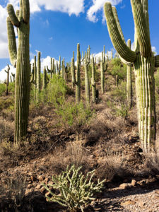
When I was roaming around Black Canyon City a couple of weeks ago, I was on a street with homes along the right side and open land on the other. On the hillside was a dense stand of saguaro growing, and I knew I wanted to capture their image, but the field had a barbed wire fence. As I drove further down the street, I found an open spot. A gravel road led onto the property, so I parked the truck and got out for a closer look.
Saguaro Grove
Saguaro Grove – these giant cacti grow exceptionally well on south-facing, well-drained slopes.

I’m usually cautious about trespassing, so I always look for Keep Out signs. After all, this is Arizona, and I’m allergic to bullets. I saw no postings nearby, but a sign was down the road. It read, “Agua Fria National Monument.” I thought, “There’s a national monument? Here, this close to Phoenix? Why don’t I know about this?” All the open areas from Black Canyon City to Cordes Lakes and east of Interstate 17 were given monument status in 2000 because the Agua Fria River is a treasure of ancient dwellings, petroglyphs, and artifacts. There are no freeway signs, visitor centers, or entrance fees. There is a hiking trail that runs its length, and you can walk, bike, or ride horseback. Bloody Basin Road cuts through the monument; from it, you can access a couple of rugged jeep trails. So, I’ve already mentally filed it away as a future project.

Meanwhile, back at Black Canyon City …

Saguaro grows exceptionally well on well-drained south-facing slopes, so when you see a grove like this, you can tell the compass direction—like moss on the north side of trees. The overhead clouds are remnants of Hurricane Rosa, which dumped enough rain to plump up these giant cacti. They look like my uncle making his way to the couch after Thanksgiving dinner. I could have titled the image with a snarky name, but I didn’t. It’s merely titled Saguaro Grove.

You can see a larger version of Saguaro Grove on its Web Page by clicking here. I hope you enjoy viewing this week’s post and return next week when we show another featured image from Black Canyon City.

Until next time — jw

Reach for the Sky Picture of the Week

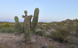
I drove down past the Safeway into the Vulture Mountains last evening to do some photography. My intent was to capture an image of Vulture Peak shining in the sunset, so I drove around until I found an angle where I could get the image that I visualized and set up my camera. It didn’t work. From the spot I was shooting, it would work better as a sunrise shot. While at that scene, I saw this funny little saguaro on my right and decided to shoot it instead. I call it little, but even with its center trunk lopped off, it’s taller than I am.

Reach for the Sky
Reach for the Sky – A near-full moon rises behind a decapitated saguaro in the Vulture Mountains.

By the time I got set up for this image, the sun was down and it was already into the blue hour—the period after the sun has set but still light enough to see colors. It wasn’t until I began to concentrate on the saguaro that I noticed the near-full moon rising, so I’m going to toss it in for no extra charge. The cactus is interesting for a couple of reasons. Somehow it lost the top of its main trunk and it has sprouted new arms, of which one looks like a melon … or even a head if you have a vivid imagination. The second notable thing is that it’s still plump with water even though we haven’t had rain for months—which may be the reason it was able to generate the new growth. In any case, it has cool apartments for woodpeckers, cactus wrens, and maybe an owl family this summer.

I called this shot Reach for the Sky and you can see a larger version of it on its Web page here. I hope you enjoy viewing my new pico’-week and that you’ll tell me what you think. Maybe next week, I may get out of bed early enough to get a better version of my first idea.

Until next time — jw

Saguaro Station Picture of the Week

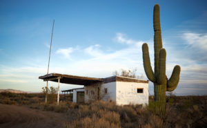
This week’s new photograph wasn’t taken in Aguila for a change. I took it on the way home from my outing there. This is the second version I’ve taken of an abandoned service station at the Arizona Route 71 and US Highway 93 intersection. My first shot of this place—called Station 71—was before sunrise in November 2015. When I stopped this time, the sun was setting and I thought the stately saguaro added to the story of this old building. This version—called Saguaro Station—can be seen on my Website here.

Saguaro Station
Saguaro Station – An abandoned service station in the late afternoon sun along US 93 near Congress, Arizona.

I actually travel through this intersection often, and when I do, I try to stop and look for new angles. Usually, the light isn’t right or nothing interesting jumps out, but this day the beautiful light on the building’s graffiti-covered end-wall forced me to drag the tripod out of the car. The failing light also shows off the saguaro’s pleats.

The next time I stop, I should try to find what gas station brand this was. The gas signs are gone—no doubt scavenged by collectors—but maybe there’s a clue hidden inside the building among the tarantulas and rattlesnakes. In the next couple of years, this intersection going to be an exit for the new Interstate 11—replacing US 93 for traffic between Phoenix and Las Vegas. City planners expect the new highway to bring growth to this area and there’s talk of a Wal-Mart planned for this intersection. Ironically, that traffic would support a new gas station in this spot.

I hope you enjoy seeing this new photo and let me know what you think in the comments. Which version do you prefer? If you enjoy this post, please click the like button below.

Until next time—jw