When I go to a new town like Seligman, I’m like any other visitor. I take in the bright lights and displays along the main street. After all, that’s the show. The merchants want to attract you into their stores. It makes good business sense. The old maxims counsel you to, “Put your best face (foot) forward,” and “Show your better side.” They can’t make a living if no one comes in. That’s why the storefronts are updated continuously with fresh paint, displays, and signs.
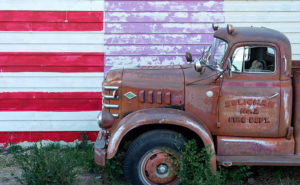
Fire Flag – A retired Seligman fire truck sits along a clapboard store.
But sometimes there’s good stuff out back, and that’s why I walk a new town’s back streets and alleys. They aren’t all spit-polished, and you can see a building’s structure untouched since it was new. If you’re looking for history or art, an alley is more rewarding because merchants ignore it.
That’s how I found the subject for this week’s featured image. It wasn’t behind but along a clapboard-sided store. It has a big faded hand-painted flag and retired fire truck which could be a museum display. The mural alone was a good shot as was the fire engine, but I decided to go for a twofer. The block of purple is a mystery, but it works in the photo. I named this image Fire Flag because it was a short, catchy description of the image.
You can see a larger version of Fire Flag on its Web Page by clicking here. I hope you enjoy viewing this week’s post and come back next week when we’ll show another featured image from Seligman and Route 66.
Well, that didn’t work; it’s not musical and doesn’t even rhyme. I suppose I shouldn’t try to mess with Bobby Troup’s song. I haven’t any musical talent anyway. My grandmother repeatedly told me, “You couldn’t carry a tune in a bushel basket.” The only thing I can play is the radio … while I’m driving, and when I drive across northern Arizona, that 1946 song inevitably pops into my head. Everybody from Bing Crosby, Chuck Berry, to the Cramps, have recorded it, so the tune has legs.
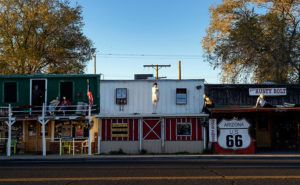
Rusty Bolt-The Rusty Bolt drags bus-loads of tourists into the saloon to try their signature cocktail-a Rusty Bolt. I assume it’s a Rusty Nail in a bigger glass.
The reason that song has become an earworm in my brain is that Queen Anne and I drove two and a half hours to Seligman for this month’s photo shoot and we never left Yavapai County. For fifty miles, Route 66 runs along the northern border of our county—from Yampai to Ash Fork—and Seligman is at the west end of the most extended active section.
I’ve already recalled some of my personal experiences traveling cross-country on US 66, so I don’t want to be your grandpa continually retelling the same stories. But for the next generations, I’ll summarize some of the road’s highlights. Completed in 1926, U.S. Route 66 was one of the first paved highways across the west. It ran from Chicago to Santa Monica and provided an economical alternative to train travel. It was known as the Will Rodgers Highway, Main Street America, and the Mother Road. During the Dust Bowl and Depression era, thousands of migrants traveled west on the highway in search of a new life, a story that John Steinbeck captured in his epic novel Grapes of Wrath. My generation grew up watching Route 66 on a black and white 17” TV. The show’s two male characters—Martin Milner and George Maharis—traveled across the country in a Corvette. Their travels involved but weren’t limited to 66, and no one questioned their sexual orientation back then. The show turned the highway into a symbol of escape and adventure and permanently linked the Corvette to Route 66. (Incidentally, the show’s theme song made Billboard’s top 30 list.) The building of the Interstate System killed Route 66. The freeways went around towns and eliminated stop lights and speed traps. Without Federal money, states abandoned the road and began digging it up.
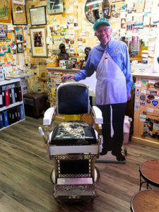
Angie’s Chair – Angie (cardboard cutout) and his wife-Vilma-founded the Route 66 revival movement from his Seligman barber shop and pool hall. I wanted to get my hair cut, but he was home sick with the flu.
In 1978 when Interstate 40 opened and bypassed Seligman, the town’s commerce disappeared, and that put the town’s existence in jeopardy. But the town’s barber administered CPR. Angel Delgadillo met with representatives from other affected communities, and they formed an organization to turn things around. They worked to make the old US 66 a Historic Highway. Within a year, the association successfully lobbied the Arizona State Government to declare the section between Kingman and Seligman a Historic Highway, with parts from Ash Fork to California added later. After that, other states followed our example, and they tagged sections of the remaining road as historic.
The nostalgia caught on, and soon gift shops were selling Route 66 kitsch and memorabilia. Each year, the Historic Route 66 Association organizes a Fun Run. On the first weekend in May over 800 cars gather in Seligman for a car show in the morning before driving en masse to Kingman for the night. The next day, they continue to Needles. Most of the participants are of my generation and are driving cars they wish they had in high school. 2019’s annual run will be the 32nd year.
On our Seligman visit, we saw several businesses competing for customers by displaying memorabilia and vintage cars out front. Of the samples we saw, this one stood out. It’s the Rusty Bolt Saloon and—along with the signs and flags—they added mannequins to their building. I’ll tell you that when you drive by, you think there’s a wild party going on here. I took this shot early in the morning as the sun came up and I liked how the statues stood out in the sun. The other advantage to shooting that early is the lack of tour buses parked along the sidewalk.
You can see a larger version of Rusty Bolt on its Web Page by clicking here. I hope you enjoy viewing this week’s post and come back next week when we return to Seligman and more photos.
In the spring of 1959, my dad traded in his ’52 Ford Business Coupé for a brand new Ford station wagon. It was two-tone — white over red — with red vinyl seats, push button radio and 4-60 air conditioning — you’d roll all four windows down at 60 miles an hour for greatest effect. Neither my three sisters nor I had a clue why he bought the new car. His pride and joy was the ’56 Crown Victoria that was in the garage. We didn’t need a reason, and we didn’t care. It was new and shiny and had pretty wide white walls. As we found out later, he bought it so we could visit his uncle in California. The six of us were taking a two-week road trip from Pittsburgh to LA and back. We were the Griswolds prototype.
When my dad was behind the wheel, he focused on the destination. I don’t think the man would have stopped for a bathroom break had not one of us been whining from the back. We started out on Friday evening, and drove all night to Chicago, but not stopping until the next evening in Joplin. Mom may have done a stint, but we were asleep in the back.
We were on Route 66, The Mother Road. We didn’t appreciate its significance then, the TV show wouldn’t air for another year and we were too busy making truckers honk their air horns. My dad was relentless, he wouldn’t stop to see the Jackalope, the Thing, the Grand Canyon, or any of the other cool places that cost time and money. Can you imagine torturing kids like that? Signs along the road … “The Thing – 50 miles”, “The Thing – 10 miles”, 5, 4, 3, etc. At least he didn’t stop the car to kill us. Of course, that would have meant stopping the car.
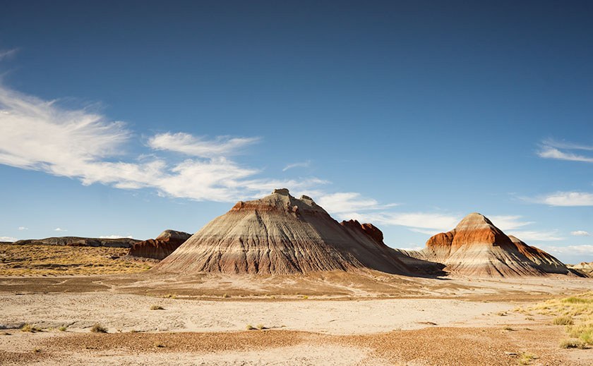
A pair of Chinle Shale formations showing the different colored layers of volcanic ash.
He did stop at one place — The Petrified Forest — he had to. The stupid road ran right through it. He said we could stop and go through the park and we were giddy. Finally, we’d see something and maybe get a break from the treeless desert we drove through. A forest, with trees; made from rocks … yeah! Imagine our shock when we saw all the rock-trees were knocked over. This wasn’t a respite from the desert, this was just more desert … with cool looking rocks. “There’s so many of them, can I take just one mom … huh? … huh? … Can I?” Even now, I sound so annoying, I want to slap myself.
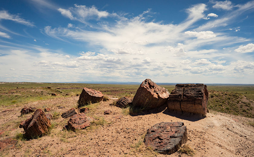
The stops along the park road show off the park’s best. This is the Large Trees exhibit.
Within a month of our return from that vacation, my parents sold our Monroeville house and the second car. They got rid of most of our excess baggage and we moved to California. We settled into a Sylmar rental house so quickly that none of us kids missed a day of school. Although our family drove along Route 66 four more times, we never again stopped at the Petrified Forest. After I moved to Arizona decades later, I made two photography outings to the park on my own.
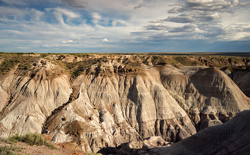
My favorite part of the park is Blue Mesa with its maze of Chinle Shale erosion.
Yesterday, I took Queen Anne to visit the park for her first visit. Despite what Google Maps says, it’s only an hour trip along U.S. Route 180. The road follows the Little Colorado as the river descends from the grass-covered Springerville Volcanic Fields, past the little town of Saint Johns where the cinder cones give way to dirty tan sandstone. The red silt river played hide and seek, only revealing itself when it passed under the empty highway. As the elevation continued to drop, the sandstone formed low tables and — where water eroded the softer underlying shale — large angular blocks broke off and slumped on the red soil below. Further along, I saw a bright white swell that I guessed was Chinle Shale and I knew we were almost there.
When we visit a national park, we head straight to the visitor center. That’s where you learn stuff … besides, I love those giant relief maps — which they didn’t have here. This time, we sat through the documentary film, browsed the museum exhibits, picked up some pamphlets, and bought two photo books before driving north along the road. As a photographer, I want to see the ‘long-shot’ first, so we slowly drove the road’s length. I made mental notes as we went, and tried to figure out how I’d shoot those images after the crowd thinned. After we turned around, we stopped at each pull-out, walked the trails, and photographed what we saw. As the day passed, I watched how the light and the sky changed as clouds formed over the White Mountains and the San Francisco Peaks before they drifted away in the invisible air stream.
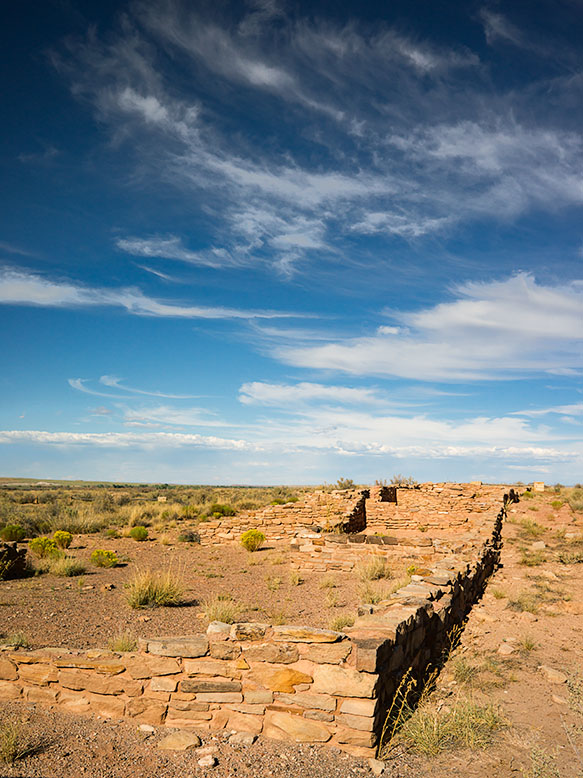
Along the bank of the Puerco River, a Pueblo ruin can be explored at leisure.
We discovered that the park isn’t just about petrified trees, it’s about layers. There are layers of soil and rocks, layers of flora and fauna, and layers of settlers and travelers for everyone to see in an open time capsule. As each rainy season washes away soil, more fossils are uncovered. There are fossils of ferns, grasses, lizards, crocodiles, toads, dinosaurs … and yes, trees. People before us settled this land, and they’ve left things behind for us to find. They left arrowheads, baskets, weaving, petroglyphs, and along the bank of the Puerco River, a pueblo ruin. Other people have traveled through the park. The Mogollon’s had trade routes to and from the Pueblos in New Mexico. In 1853, Lt. Amiel Weeks Whipple used those trails to survey the route now used by Burlington Northern Santa Fé Railroad. The tracks were a basis for U.S. Route 66 and now Interstate 40. These routes are layer upon layer of traders and countless migrants moving across the Colorado Plateau.
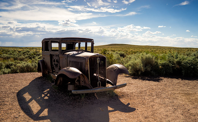
To commemorate the famous highway, the park service placed a 1932 Studebaker shell at the place where the highway and park road crossed.
Even though the National Park’s mission is to preserve and protect natural history, I was pleasantly surprised to see a nod to history more recent. There’s a turn-out north of the Interstate 40 bridge marked by a rusty skeleton of a 1932 Studebaker on blocks. It’s the spot where Route 66 passed through the park. The pavement has returned to grass and sage, and only the telephone poles give away the road’s alignment. The road of my past. While I was photographing the scene, I swore I heard distant echoes of four kids in a red and white station wagon, begging dad to stop.