We’ve spent March exploring the Black Hills—an interesting group of low mountains on Wickenburg’s north side that gets their name from the dark surface crust on their top. I was able to shoot them from different perspectives by driving the old mine roads that my SUV—Archie—could navigate easily. While I’m out jaunting about and looking for different angles of my subject, I try to keep an eye out for other good scenes—and that’s the case with this week’s featured image.
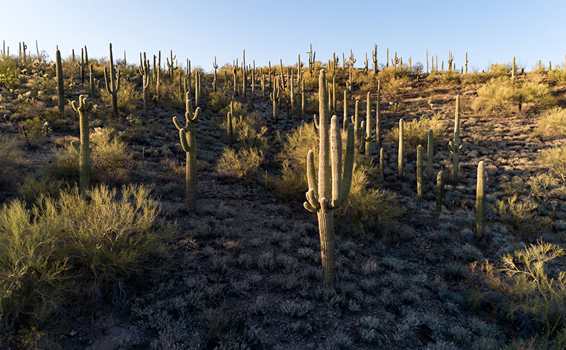
When I drove out Rincon Road a couple of weeks ago, I intended to get the shot Black Hills—last week’s featured image. While I was there, I discovered a hill covered with saguaro. As I’ve written before, saguaro does well on a south-facing well-drained slope, and when I see a stand like this, it makes me happy. This is a healthy forest. Since I’d already invested the time driving out there, I also took this shot.
Saguaro Bouquet-A small but a dense grove of saguaro growing on a hillside near Wickenburg, Arizona.
I named this week’s image Saguaro Bouquet jokingly because—although they each weigh a couple of tons—it looks like you could pick them for a Mother’s Day bouquet (hey, no one said I was normal). Although this grove is small, it’s densely packed along the hillside.
There are some other things I see in the photo. It was still winter when I took it, but the scene will change dramatically as the weather warms next month. For example, the little gray bushes covering the ground are brittlebush. In a couple of weeks, they will sprout yellow daisy-like flowers. Shortly after that, the palo verde trees will start flowering, adding more yellow. Finally, in May, the saguaro will be adorned with large white blossoms. That’s an Arizona Highways kind of picture. If you’d like to see it yourself, ask me, and I’ll give you the map coordinates.
I am happy you took the time to view my new photo. You can see a larger version on its Web Page by clicking here. Be sure to come back next week for a complete change of pace. I promise that for April, there won’t be a single saguaro.
Queen Anne and I spent a couple of days last week visiting our favorite foreign city. That’s right; we went to Algodones, Baja California. I had to see my dentist and have a couple of holes in my head filled. Instead, she worked on my teeth.
Algodones (it means cotton in English) is famous for liquor stores, pharmacies, and dentists. The little town has over 350 dental offices within a 10-minute walk from the crossing. It’s straightforward for visiting Snow-Birds to park in the lot, walk across, hit the liquor store for liquid courage, get a tooth fixed, and buy pain relief on the way out.
During the pandemic, the Mexican border is closed, but there are exceptions for medical, educational, and commerce visits. The big restriction placed for Algodones was closing the crossing at 2:00 pm instead of 10:00 pm. Early on, many people didn’t know that, so the wait times at the customs house were nil. Well, the secret’s out. The line of people going through customs was over a mile long. There’s a break in the gate where our dentist is, and when we can join the crowd there, it’s a half-hour wait. On Tuesday, the end of the line was three times that distance. It was 12:40 pm when we started. At 2:00, when the siren blew, we were only half-way to where our usual starting place.
The way customs close the border is interesting. If you’re in a car, you’re out of luck. You have to drive an hour to San Luis or Mexicali, where the crossings are open 24 hours. But if you’re a pedestrian in line, they stay open until the end of the line. That’s good because I thought we were going to sleep in a cardboard box like homeless people. It was 3:30 by the time we stopped at the Yuma Carl’s Jr. for lunch/dinner.
There was something weird on this trip that has never happened to us before. When we made it to the line’s the halfway point, an American guy jumps out of his car—taps on my shoulder—and asks if we want a ride in his car. “You’ll be in line for another couple of hours, but the cars are crossing in a half-hour.” His car had four people in it already. Anne and I glanced at each other and declined. I’m of the generation that said, “Gas, grass, or ass. Nobody rides for free.” What if we got in the car and he demanded cash that we didn’t have. We’d be back on the street and at the back of the line again. Everyone around us also turned him down. What would you do?
Get to the Picture
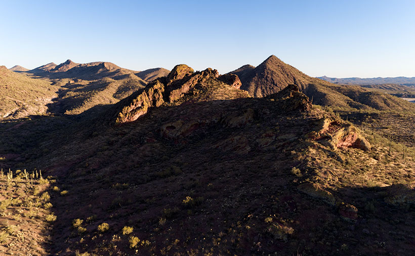
Black Hills – As the Hassayampa River flows down from the Bradshaw Mountains, it cut a gorge through the Black Hills, known as the Hassayampa Box Canyon.
Speaking of this week’s picture . . . (I know it’s a lame segue, so I won’t charge you for this issue.) This is another view of the Mountains/Hills that we’ve been photographing in March. I found that they’re called the Black Hills because of the dark crust along their tops, hence the photo’s title. This version was taken on their other side, looking back to Wickenburg.
If you own one of my 2021 calendars, these rocks are the same subject as the March photo. This time I wanted to get a closer look at the interesting fault thrust in the foreground, but when I processed it, I realized I had captured more.
You can see the Hassayampa River as it flows down from the Bradshaw Mountains on the mountain’s left side. But here, it turns right—behind the foreground rocks—and it cut a gorge through these hills. It’s a local attraction called the Hassayampa Box Canyon. Unfortunately, it’s hidden in this shot, but there is a glimpse of the river after it hits the Hassayampa Plain on the right side. Here it turns into a wide, sandy, and the water flows beneath the sand. That’s why the native tribes call it Hassayampa—upside-down river.
I hope my photo brings completeness into your life. You can see a larger version on its Web Page by clicking here. I like reading your comments, so feel free to add your two cents below. Be sure to come back next week for another image from the Wickenburg area.
My sweetie loves me! Incredible, I know. After living together for over 32 years, this morning, on Valentine’s Day, she asked me what I would like for a romantic dinner. The question took me by surprise. I had to think about it. I puzzled about which meals nurtured the minds and souls of great artists. What’s the most romantic place I can think of? Then it hit me—Giverny, France of course—home of Claude Monet. So I looked up the restaurant menu from Hotel Baudy—a scene in several of his paintings and where he gathered with many of his Impressionist cronies.
I Google translated each menu item looking for something manly and not cheesy. Halfway down the list, the obvious choice jumped off the page. It has three of the world’s best things you can put in your mouth in one dish: Magret de canard poêlé aux cerises et sauce au porto—seared duck breast in a cherry-port sauce. Ah—I slobbered all over my keyboard, thinking about it.
I rushed into the living room where Queen Anne was reading the Sunday paper dressed in her threadbare robe, fuzzy slippers, and rollers. I blurted out my dinner choice. I guessed wrong. She explained that what she meant was, “Which of the packages in the freezer do you want me to microwave for you—and you can’t have the one that I picked.” <Sigh> So, I picked the other TV dinner. Ain’t love grand?
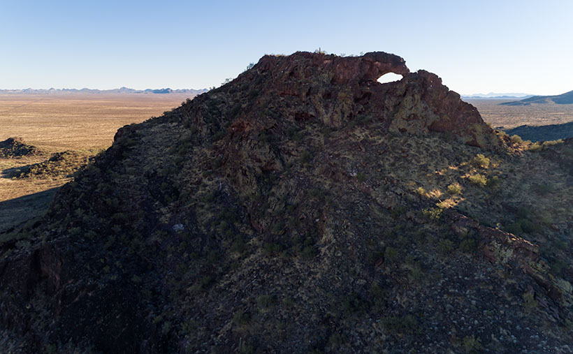
Eagle Eye East – The view from the top of Eagle Eye Mountain looking east towards the arch on Eagle Eye Peak in Aguila, Arizona.
Letting my romance wilt on the vine, let’s talk about this week’s featured image. As I promised last week, I wanted to show you the Eagle Eye Arch from another angle. In this image—that I call Eagle Eye East—we’re looking at the arch from the south side of the mountains in Aguila. I shot this picture from the top of Eagle Eye Mountain facing Eagle Eye Peak, and that’s why the arch seems more distant than last week’s photo. Since this was the sunny side of the mountains, it better shows how rough the lava surface is. I like how the bright green saguaro and palo verde contrast with the reddish-brown rocks.
Another interesting thing in this image—to me—is the background mountains. The Forepaugh Range is on the right and beyond them is the town of Wickenburg. Beyond the Aguila Valley, the tall mountains on the left horizon are the Weavers, and that’s where we call home.
You can see a larger version of Eagle Eye East on its Web Page by clicking here. Be sure to come back next week, and I’ll show you the final shot that I liked from my outing in Aguila.
The last time I wrote about Aquila’s Eagle Eye was in 2018, and I didn’t have much to say about it—other than it was there. That post included a photo I shot with a telephoto lens from miles away. I had to do that because much of the land around the peak is posted as private. There were two comments in that column. The first was from Fred, who thanked me for pointing the bridge to him, and the second was from my old friend Gary, who chastised me for not getting closer.
Since I’ve been hanging around Aguila this month anyway, I thought I’d try to make Gary happy. About three miles south of Aguila are mountains on the east flank of the Harquahala range. They almost have the same name; Eagle Eye Mountain is on the west, while Eagle Eye Peak is the lump of lava to the east (they touch one another). The latter peak is the one with the window on top.
Eagle Eye Peak – A natural arch on top of a peak several miles south of Aguila, Arizona. Behind Eagle Eye is the Harquahala Plain, which stretches south to the Big Horn Range on the horizon.
You can get very close to the arch if you drive to the old cemetery where Eagle Eye Road bends around the mountains. The bad news is that you can’t see the arch from there because it faces east, and all you see are the rocks from the edge. There’s a better view if you scramble up an 800′ cactus-infested lava hill like an insane person, but I did the lazy thing. I brought my drone, and I flew it to the mountaintop. Once it got up there, I rotated it to the right and composed this shot.
The Eagle Eyes, like a lot of low desert mountains, were formed from volcanic activity. This particular pair of mountains is basalt-covered limestone. The rocks are much darker than the rest of the Harquahala Range. They appear as shadows on the horizon. Their surface is rough and pockmarked, like they had a bad case of acne. They are riddled with caves formed by air pockets in the lava.
I didn’t find an article that explains how this arch was formed. I don’t think it was formed from wind erosion. The rocks aren’t polished. It could be from one of those air voids in the thin-walled lava collapsing. My favorite guess is this: If this is Rhyolite—slow-moving lava common to peak formation—then maybe a cone of lava formed vertically, and as it cooled, it slumped over and froze in place. At least, that’s what it looks like to me. What do you think?
Well, Gary, I hope you’re happy. Click here to see a larger version of Eagle Eye Peak on its Web Page. Be sure to return next week when I’ll show you the arch from a different perspective.
It’s already the last day of January. Where does the time go? After looking at this month’s photos, it seems that I spent a lot of my time around Aguila—with good reason. That’s the route that Queen Anne and I take when we travel west, so I knew there was stuff to shoot, and it’s close by—well if you consider an hour close.
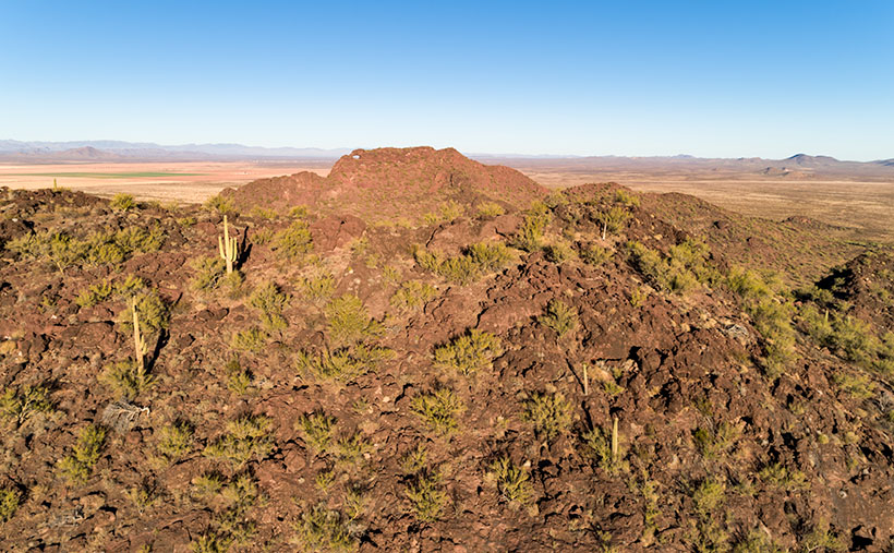
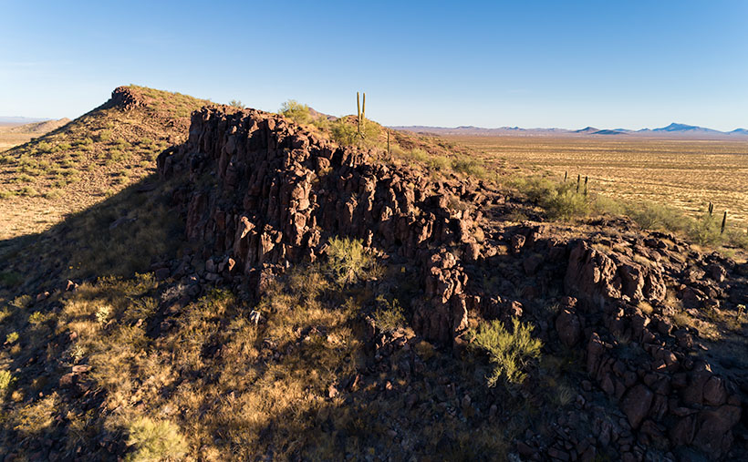
Foothill Uplift – A pair of hills thrust into the air by plate tectonics.
This week’s featured image comes from the same area. I didn’t have to travel far after I captured last week’s picture—Harcuvar Forest. In fact, all that I needed to do was turn around. OK, let me explain. I wanted to shoot the saguaro forest ever since I first saw it on a trip to Robson’s Mining World, but it’s miles north of the highway and tucked under the cliffs of the Harcuvar Mountains. My topo map shows a jeep road that runs behind a couple of hills situated between the highway and the forest. The hills screen the cactus patch from the highway. So, me and Archie did a little four-wheelin’.
After I had finished shooting the saguaros, I noticed that the north side of the hilltops behind me weren’t rounded as they appear on the south. Instead, they had a ridge of broken rocks—plate tectonics fractured them and pushed them towards the sky. Since I find edges like these interesting, I decided to waste some time photographing them.
This week’s featured image is the result of my curiosity. I call this photo Foothill Uplift. There are a couple of things that I like about this image. I like how the second hill repeats the pattern of the foreground one. It’s like they’re lined up for presentation. The same wedge shape shows up again on the photo’s right side. Along the horizon and on the far side of the Aguila Valley is our old friend Black Mesa. It’s the western high peak of the Vulture Mountain Range that stretches all of the ways back to Wickenburg. Finally, I love the double-headed saguaro, which I couldn’t see from the trail. It’s the garnish that completes the cocktail.
You can see a larger version of Foothill Uplift on its Web Page by clicking here. Be sure to come back next week, and I’ll see what I can scrounge up from around the neighborhood.