Beer Can Picture of the Week

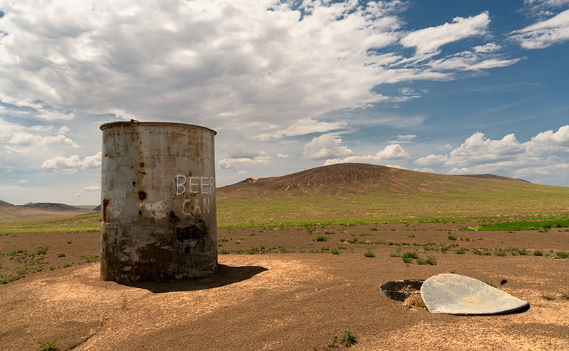
Beer Can - An uncouth visitor left an empty beer can near a cattle tank on the Babbitt Ranch.
Beer Can – An uncouth visitor left an empty beer can near a cattle tank on the Babbitt Ranch in Northern Arizona.

If you drive north on US Route 89 from Flagstaff, you get to see one of the best scenic views in the country. To get there, we need to get around the San Francisco Peaks—the remains of an ancient volcano, and they rise over 12,000 feet—Arizona’s high point. Route 89 is on the east flank of the peaks and winds through Flagstaff suburbs that suffered fire and flood damage this spring. As the road climbs a gentle grade, the scenery changes from open meadows full of new homes to a ponderosa forest. There was substantial fire scaring, but many tall, red-barked trees survived.

At the top of the hill, the four-lane highway briefly flattens before you reach the Sunset Crater National Monument entrance road and the 7288-foot elevation marker. A mile further, the road suddenly drops from its mountain elevation to the Little Colorado River Bridge, 3100 feet below and 35 miles away. On an exceptionally clear day, you can see into Utah—I swear.

This vista encompasses every rainbow color. On the left, the dark green pine trees grow down the mountain slope until they make way for lighter green junipers and then the yellow grass-covered cinder cones on the Babbitt Cattle Ranch. The twenty-one miles of perfectly straight blacktop divides the east side from the west. On the east side, patches of black lava flow give way to the distant Painted Desert colored in hues of reds, whites, greys, and purples. Above everything, the deepest blue skies—a color they don’t make anymore—tie the canvas together.

Every time I see this scene through my windshield, I have a smile on my face. My joy is probably because I’m on my way to someplace fun, like Lake Powell, Lee’s Ferry, the Grand Canyon, or (shudder) Utah. As I drive down the mountainside, I habitually switch my dash view to see if I can recover my gas mileage before I hit the bridge. It keeps my mind occupied for the next half hour. As you all know, I’m easily amused.

Except for a few visits to Sunset Crater and Wupatki National Monuments, I’m usually passing through this wonderland. But, during our July visit to Flagstaff, Queen Anne and I came to the mountain’s north side to photograph the cinder cones in the San Francisco Lava Field. They’re technically on the private ranch owned by the Babbitt family. The Arizona pioneers that have been successful ranchers, merchants, and politicians.

Before we drove out to the ranch, I checked in at their store in town to see if we needed a hall pass. “No, if the gate is open, you can enter as long as you’re respectful and drive on the roads.” Taking the caution to heart, I was surprised when we reached the old trading post that there wasn’t even a gate to open. The dirt road was so smooth that we didn’t tax our Jeep’s capabilities—not even its four-wheel drive. It’s only a couple of miles to the lava field, but before we got there, we drove by a cattle tank where some uncouth slob left an old beer can. I was so upset that I stopped to document what the thoughtless cretin had done. The picture came out so well that I made it this week’s featured image. I call it Beer Can.

As you might have figured out already, it’s not actually a beer can but graffiti that some vandal painted on the side of one of the ranch’s metal water tanks. They’re used to hold water for the cattle during the dry season. Indeed, the lettering is still vandalism, but one that appeals to my perverted sense of humor. Besides the tank, I don’t know what the trash can lid is. Perhaps it’s a cache to store surplus hay for when a herd is in the area.

An unnamed volcanic cone appears in the background, and it doesn’t seem very high until you try climbing it. Neither Anne nor I tried scaling anything on this trip because there weren’t any stairs for me to bitch about, so as usual, Anne stayed in the Jeep reading her Kindle while I ran around taking pictures.

You can view my Web version of Beer Can on its page by clicking here. We have a month’s worth of photos from the lava field, so we’ll be spending October here. I hope you enjoy this week’s pictures and come back next week when we present more. Be sure to join us then.

Till next time
Jw

BTW:

We recently discussed making a Route 66 photo trip and producing a large coffee-table book from the new photos. After burning down my calculator, we’ve put off any such trip until later. We’ll wait and see what happens next year.

Cochise Ranch Airfield Picture of the Week

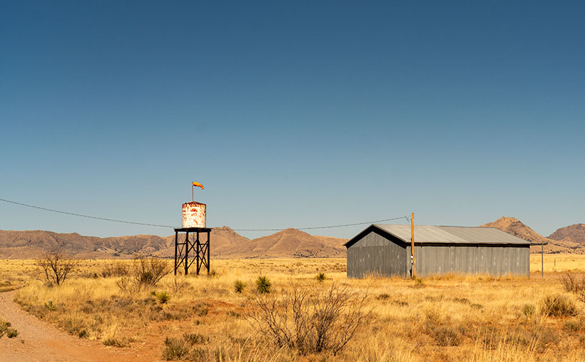
Cochise Ranch Airfield - It's common for ranchers in remote Arizona communities to build private airfields.
Cochise Ranch Airfield – It’s common for ranchers in remote Arizona communities to build private airfields.

As a kid, one of the Saturday morning cowboy shows I watched was Sky King. The pitch for the show probably went something like this: An Arizona rancher has a spread so large that he has to use an airplane to manage it. Because our rancher (let’s call him Sky King) has this fantastic resource, the local sheriff calls on him to help find lost hikers, bank robbers, missing children, and commie spies. It’s pretty unbelievable—right? But that’s how it went. Sky King was not my favorite cowboy because he didn’t have a pretty horse. After all, how could you chase bandits and shoot at them if you weren’t riding a horse?

I don’t know about chasing bank robbers, but large ranches with private airfields are common in Arizona. I didn’t realize how pervasive they were until I studied to get a drone license and learned how to read aeronautical charts. There are several private fields near where we live.

I can think of several reasons you could justify a private field if you lived in a remote place like Cochise County. Flying into town for supplies would be helpful, but you’d need a fair-sized plane to bring home packs of Costco paper towels and toilet paper. We have trouble getting those items in our Jeep. Emergency medical visits are second on my list off the top of my head. The rancher files to a hospital, or Air Evac comes out to the spread.

The Sky King Memory block fell into my recollection dispenser when we drove by this windsock and hanger on our commute between Willcox and Chiricahua National Monument. That’s why I stopped and took this shot. I call this week’s picture Cochise Ranch Airfield, and it shows a weathered water tank, orange sock, and corrugated hanger before a clear blue sky. As you look at it, you can hear the announcer’s golden voice saying, “From out of the clear blue of the western sky comes Sky King!” Now that we’re all older and more cynical, don’t you wonder why Penny—a pretty young blond pilot and accomplished air racer—lived alone out in the desert with her flashy old uncle?

You can see a larger version of Cochise Ranch Airfield on its Web Page by clicking here. Next week we’ll stop in a ghost town and look at some of its ruins, so I’m sure that you’ll want to see that.

Till Next Time
jw

Yucca Hedge Picture of the Week

I’m a morning person. I wake up at dawn’s first light. If I try sleeping in, I just lay in bed with my eyes open until I give in and get up. Then, I work a few hours (writing blog posts, for example) before we have breakfast, and then it’s time for my morning nap. I haven’t needed an alarm since retirement. In fact, when I need to get up early and set a time on my clock, I wake up before it goes off. That’s the story of this week’s picture.

When Queen Anne and I traveled to California a couple of weeks ago, we only had four days, so that’s two days of driving and two days for play. Since I like photographing in the early morning and late afternoon, I planned to be shooting during those times, even if it meant getting up in the dark.

One of the subjects that I wanted to take pictures of was the Santa Lucia Range’s rolling foothills at sunrise. At home, the sun’s been coming up before 7 am, and since California goes on Daylight Savings Time (whatever for?), I should be good if I hit the road by then, so I set the alarm for 6:30.

During the night, I woke at 12:15, again at 1:37, and yet again at 3:30. By the time 5:45 came, I gave up. I got up and dressed in the dark so I wouldn’t disturb Her Majesty. I grabbed my gear and went out to the car only to remember that I forgot my mask, so I snuck back into the room to retrieve it. Getting up earlier than I expected meant that at least I had time to get a Quickie Mart cup of coffee.

Armed with a fresh hot cup of French Roast, I started driving up to the mountain pass. The amount of traffic that I encountered during the fifteen-minute drive surprised me. But then I realized that I was the one on vacation, and other people were going to work. When I reached the top, I found a safe place to park and waited for sunrise, but the sky was awfully dark still.

It took another hour for the sun to break the horizon. I completely misjudged the effects of the time change, and I didn’t take into account that Cambria is about 200 miles further west than San Diego. When the sun finally came up, I began to slowly make my way back down to the ocean stopping and shooting along the way.

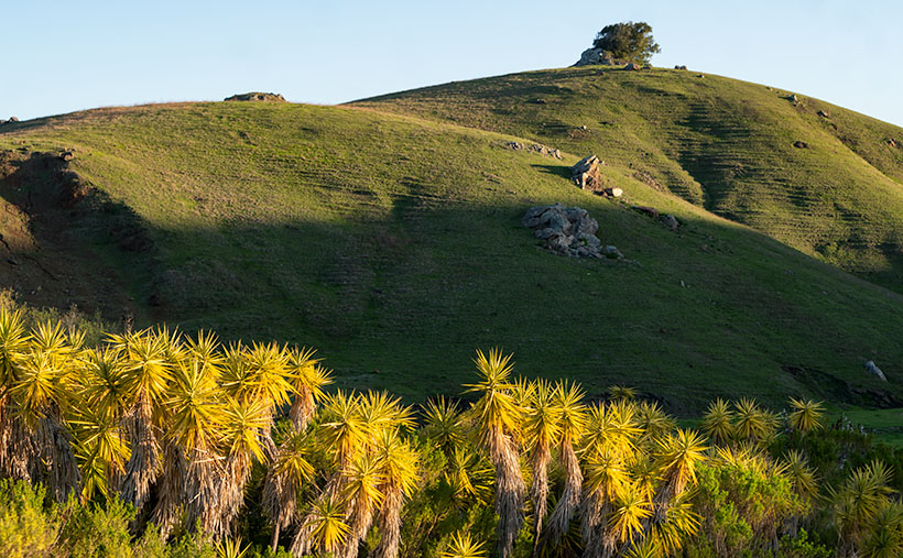
Yucca Hedge - The morning sun highlights a hedge of Yucca while shadows remain on the background hills.
Yucca Hedge – The morning sun highlights a hedge of Yucca while shadows remain on the background hills.

This week’s featured image was taken at a ranch only a few miles inland of the Pacific Coast Highway. The owners had planted a hedge comprised of Yucca plants along their drive. They were in full sun while shadows played on the hills behind them. The contrast in light is interesting, and how the spikey Yucca leaves contrast with the rounded hills. The soft morning light also brings out how years of grazing cattle have created terraces in the hills. That’s good because the cattle would otherwise fall over and roll to the bottom. This terracing reminded me of New Zealand, where sheep have changed the landscape in the same way.

I called this photo Yucca Hedge, and you can see a larger version on its Web Page by clicking here. Be sure to come back next week when we add another picture from our time along California’s central coast.

Until next time — jw

Ferguson Valley Picture of the Week

Queen Anne—as my mother would frequently say—is deaf in one ear and can’t hear out of the other. However, she can tell the difference between me calling, “Anne” and the blood-curdling scream, “Aaannee.” I know this to be true because it happened this week when she rushed to my rescue.

I was busy watering the potted flowers that live on the back deck. We keep them there in the shade during the summer, and I have them arranged on the back doorstep, so the bunnies don’t get to them. It doesn’t work because one or two rabbits will scamper off whenever I open the door. I used my cute water can instead of dragging the hose to conserve water. As I finished the mums, I stepped to the left toward the geraniums. There between the two pots was a western diamondback rattlesnake lying in a wad like a pile of tan rope. It laid there motionless while I involuntarily took a couple of steps backward while I screamed in a voice a couple of octaves higher than my normal range.

When she came to see what the fuss was about, I could only stutter, “porch … snake.” She stepped outside and sized up the serpent, then went back into the house. She quickly returned with a long stick that she had used to knock down a hornet’s nest on the front porch. She marched over to the rattler—which hadn’t twitched yet—took a stance, and began whacking at it. The vermin’s head popped up like it had been sleeping and tried to escape to the left. Anne was too quick and outflanked it, then she took a couple more swings at it. Then the legless reptile reversed course and slithered across the landing before it escaped down a gap between the decking and the house.

“Now what’ll we do? What happens now?” I pestered while dancing from foot to foot like I had to go to the potty. She leaned her stick against the house and went inside and called the fire department. I stood watch, ready to run away the moment I saw any movement. When she returned, she assured me, “They said to leave it alone. It knows it’s not loved and will move on when it feels safe again. If we see it again, we’ll call them, and they’ll come to remove it for us.” I was still upset, and I whimpered while nervously rocking back and forth. That’s when she slapped me across the cheek and commanded me to “Snap out of it.” She went back inside and returned with my camera bag and shoved it into my chest and instructed me to “Shut up and get in the truck. We’ll go take some pictures.”

We drove up the mountain to Skull Valley, where it was cooler. Well, it was under a hundred, and that was better than at home. We turned onto a road named Ferguson Valley Road. The dirt trail is only 6-8 miles long, but there was enough material there to keep me busy in August. The route runs by one cattle ranch and ends at a second. I haven’t found any information about this spot on the map, so I’m surmising that the Fergusons must own one of those places.

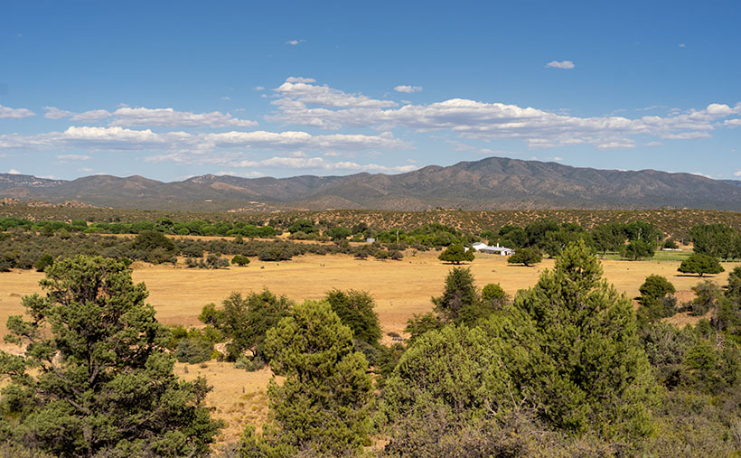
Ferguson Valley - Against a backdrop of the Sierra Prieta range, a white ranch-house sits in pretty Ferguson Valley.
Ferguson Valley – Against a backdrop of the Sierra Prieta range, a white ranch-house sits in pretty Ferguson Valley.

Perhaps they live in the home seen in this week’s featured image. I called this photo Ferguson Valley, and I spotted this scene as we crossed over a low ridge. I liked how the white ranch buildings contrasted with the juniper and cottonwood. I also wanted the clouds forming over the Sierra Prieta range. They speak to the feeble start of this year’s monsoon season. In a typical year, there would be spectacular thunderheads building in the mountains surrounding Prescott.

It’s been several days since we last saw Fang—yes, we named it—so we’re more cautious when we’re outside. We assume the snake is out there, and we actively search for it as we move about the yard. We’re careful to keep the garage door closed, and we work as a team when exiting the house. Anne stands with her back to the wall—stick in hand—and when I open the door, she swooshes through it, scans the area, and then yells, “Clear!” The swat-team imitation repeats a couple of times until we’ve safely reached the car. I’m better now, but if we have many more rattlers visit us, we’re moving to New Zealand—if they ever let us in again.

You can see a larger version of Ferguson Valley on its Web Page by clicking here. I hope you like it. Be sure to come back next week to see another image from this pretty little valley.

Until next time — jw

Seal Mountain Picture of the Week

I wouldn’t have made a good prospector if I had lived during the Weaver Mountain mining boom. Since it is Father’s Day, a quote from my dad seems especially appropriate today. “You’re nothing but a lazy bastard, and you will never amount to anything.” Thanks, dad. I’ll cherish those words forever. He’s right, though. I don’t even like to water our flowers much less pick at a mountainside. In last week’s post, I was shocked to see in the photograph of my hand, a callous below my ring. Where did that come from—I haven’t touched a hand tool in decades.

If mining is off my list, what else did men do to earn wages back then? To find out, I continued my exploration of the Weaver Range east side by following the other side-roads near Placerita. This week I drove the Wagoner Road down to the Hassayampa River. I’ve never seen that area, and besides, I might get different scenes for my drone film. I struck pay dirt (sorry for the mining metaphor).

The Wagoner Road descends the east slope of the Weavers into a river valley where the Hassayampa flows above ground. As expected, where there’s surface water, there’s farming—or in this case ranching—big ranches. They’re stacked along the river one after another. They have well-maintained fences, impressive gates, and lots of black cattle (although I did see a herd that had Wagyu markings). The valley reminded me of north Scottsdale when it was mostly Arabian horse farms. It would be an ideal place to live except for grocery shopping. There are only two ways out, the 38-mile road back to Kirkland Junction or crossing over the Bradshaw Mountains on the Senator Highway (Wickenburg is only 20 miles distant in a private aircraft, which is possible given the size of these estates).

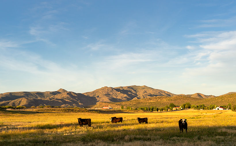
Seal Mountain - A remote mountain only seen in an obscure valley is the model that was used on the Arizona emblem.
Seal Mountain – A remote mountain only seen in an obscure valley is the model that was used on the Arizona emblem.

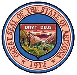
Since I was scouting new views of the Weaver peaks, I found a doozy. It’s the mountain that is in the background of this week’s featured image that I call Seal Mountain. Every Arizonian should know this mountain by heart because it was the model used for the Arizona State Seal. In 1912, who knew it existed? The only place you can see this peak is from the ranches in this remote valley. I’m impressed, however, that my local mountain range is represented on the Arizona seal.

The Arizona Seal - If you squint hard, you can see the similarity.
The Arizona Seal – If you squint hard, you can see the similarity. Personally, I would have chosen Four Peaks.

So, could I have been a rancher instead of working in a mine? MMM—maybe not. That kind of work still involves toiling with shovels, rakes, other hand tools, and even possibly riding a horse. Horses don’t like me. The last one that I road said, “Oof,” when I got on. Let’s take a closer look at that state seal—shouldn’t there be a programmer or a Web designer on it? Come to think of it, there isn’t even a real estate agent, and that’s the number one Arizona job.

You can see a larger version of Seal Mountain on its Web Page by clicking here. I hope you enjoy it. Come back next week to see what else we found along the road to Placerita.

Until next time — jw

Desert Broom and Windmill Picture of the Week

I’ve spent a lot of time in the desert recently. I’m less likely to run into snakes now that the weather is colder. But, there’s still a lot to be wary of when you’re out in the wild. There’s the cactus, especially the Jumping Cholla, the barbed wire, and all the illegal garbage scattered along the trail. One of the most frequent things I have to avoid is all of those cow pies. As I move, my eyes are on the ground; then, I stop to look up to get my bearings. There may not be a cow within miles, but their droppings are everywhere. I Googled it and found a state agricultural Website that said, “Grazing fields account for 73% of total land use in the state and 98% of its agricultural landholdings.” That’s a lot of free-range lands.

Desert Broom and Windmill-The picturesque windmills don't provide an efficient supply of water to cattle as water tables drop
Desert Broom and Windmill-The picturesque windmills don’t provide an efficient supply of water to cattle as water tables drop

You can tell ranching in Arizona is a big deal by the number of windmills and clumps of green trees you see as you drive down the highway. The green areas are usually associated with stock-tanks—the ranchers plow low dams on washes to retain the run-off, and the windmills pump groundwater into large metal tubs from which the herd gets a drink.

Not many of these windmills actually spin these days, regardless of how much the wind is blowing. Some of that is because the water table is dropping. There has been an ongoing drought here, and we’ve pumped enormous amounts of water out of the ground over the years. Instead of drilling the wells deeper, ranchers disable the windmills and truck water in to fill the tanks.

On our “One Lap of the Harquahala Mountains” tour that Queen Anne and I did last month, I was challenged with either shooting the mountain repeatedly, or finding interesting things that broke the monotonous sea of creosote, so when I saw this windmill off in the distance, I hiked in for a shot. When I got there, I liked the shiny metal fan against the sky, but I wasn’t impressed with its doughboy style galvanized tank. It looked as if thirsty bovine stampeded over it. Luckily there was some desert broom nearby that helped in a couple of ways. The green plants were in bloom—that’s as close as you get to fall color in the Sonoran Desert, and they camouflage the damaged tank.

I named this week’s featured image Desert Broom and Windmill. I like how the light was beginning to come in and how Harquahala Mountain shows in the background. I’m also partial to the high cirrus clouds, so I was pleased that they frame the windmill’s blades.

You can see a larger version of Desert Broom and Windmill on its Web Page by clicking here. I hope you enjoy viewing it. Join us next week as we continue along our trip around the Harquahala Mountains.

Until next time — jw