Tin Shed Picture of the Week

It was the fourth article about my time shooting pictures in Colorado’s San Juan Mountains when Queen Anne burst into my office—all akimbo—and began scolding me. “Fred and me this, and Fred and me that. I haven’t had press in a month.” I felt like the guy in that Toyota commercial trying to answer his wife’s question. “I’m sure there’s a right answer here.” I quickly flipped through my brain’s Rolodex of apology cards, before I realized she was right. I had to change tactics, “If you want press, you have to put your butt in the truck.” I had her.

Last week, I announced that I was leaving for one of my back-road photoshoots, and I wouldn’t be back until after dark. I packed my gear and went into the house to grab my cooler stuffed with water and snacks. When I got back to the garage and jumped into Archie’s driver’s seat, guess who was sitting shotgun? Yes—it was Her Highness.

Now that her ego is satiated, I can tell you about October’s topic. I picked out a back-road that goes from Bagdad to Williamson Valley—northwest of Prescott. On my Gazetteer map, it’s identified as Behm Mesa Road, but it had several other names as we drove it, like Camp Wood Road, Forest Service 21, or Yavapai County Route 68. The map says it’s broad and well-graded, so a passenger car should make it, but there are sections on Behm Mesa’s shoulder that are rough and rutted, so I’d feel more comfortable driving at least a pickup truck with some ground clearance.

The terrain starts in Bagdad with large boulder fields interspersed with grassy flats on the mesa tops. As the trail gains elevation, the trees change from scrub oak to juniper and ponderosa pine near the Santa Maria Mountains.  After that, the road descends into the open grasslands found around Prescott. There are a couple of cattle gates that you have to open (and close) as you cross private ranches. Most of the route’s middle section runs through the Prescott National Forest, including a part along the edge of last Augusts’ Sheridan Fire. It’s weird/unusual to see a healthy forest on the road’s north side while the south side is black and barren.
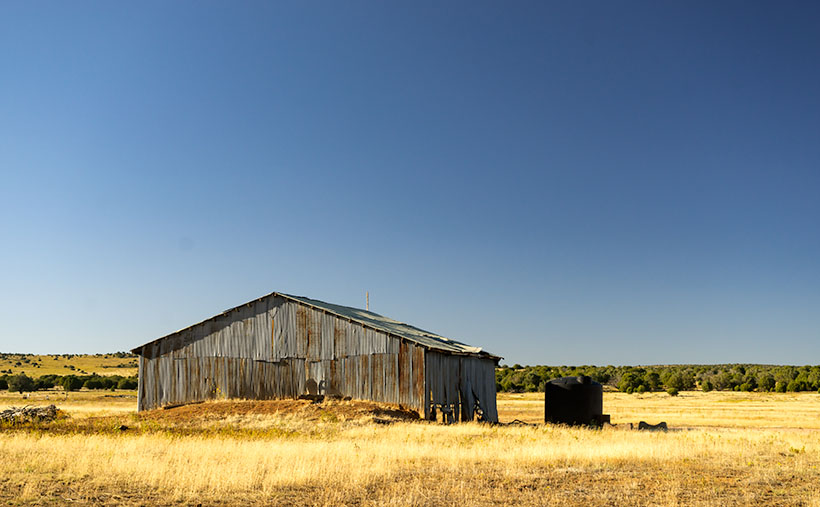
Tin Shed - An old corrugated tool shed along the Camp Wood Road.
Tin Shed – An old corrugated tool shed seen along the Camp Wood Road.

I took this week’s featured image near our starting point. As the road leaves Bagdad, you slowly travel on the shoulder of Behm Mesa—where the rough part is. September’s heavy rains may have been the cause of the ruts, and the county hasn’t regraded it. Shortly after it makes its way to the mesa’s top, you reach the first gate at a ranch house, with black cattle hanging around a water tank. Just past the tank was this tin shed in a golden grass field that had a nice contrast against the deep blue sky (opposites on the color wheel). You all know that old buildings—like this one—are a favorite subject of mine, so I had to get out and snap a picture. I call it Tin Shed.

You can see a larger version of Tin Shed on its Web Page by clicking here. I hope you enjoy viewing it. Next week, we’ll have another image to show from the drive that Queen Anne (she gets make-up press) took on the Camp Wood road.

Until next time — jw

Timberline Picture of the Week

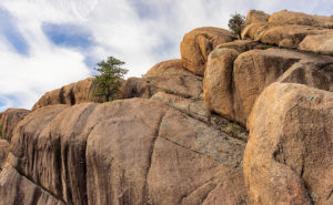
Timberline
Timberline – The subjects of this image suggest that it is on a scale larger than it really is.

The wind was warmer than I expected at this altitude. Blowing on my back, it seemed to help push me along the John Muir Trail in California’s High Sierra’s. The Mt. Whitney Trail was only a half mile further when I stopped to snap this photo of massive granite formations along the tree line.

I just made all of that up. My chances of hiking those famous trails have long vanished, but this week’s photo has a sense of scale that could work with a fictitious story like that. I took this photo I call Timberline at the Granite Dells along with the others featured this month. It’s the angle that fools the eye so that you think you’re looking at a craggy mountaintop. The trees also play tricks with your sense of scale. They’re actually shrub-size like they were scale models of ones that are much taller—bonsai versions if you will, and the sheer drop in the lower left isn’t the hundreds of feet that it seems. It’s only a dozen feet over your head as you hike the Flume Trail to the park’s northern boundary.

The reason I included Timberline in this month’s set is that it distills the Granite Dells into three simple elements; massive rocks, trees eking a living in hostile conditions, and the changing sky over them. The photo speaks of weight—or mass—and it shows a time contrast of a changing sky and momentary life against the permanence of the weathered granite. The sky changes hourly while the trees will be different in a century, but the granite will survive the next millennia unaltered.

You can see a larger version of Timberline on its Web Page by clicking here. I hope you enjoy viewing this week’s post and come back next week when we start a new set of images from a new location.

Until next time — jw

Lime Lichen Picture of the Week

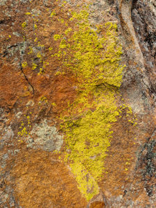
Lime Lichen
Lime Lichen – The main lichen growing in the Granite Dells is either orange or a pale green. Every so often, you’ll find a bright green patch such as this.

In last week’s post, I wrote how the Granite Dells boulders weren’t just bare rock, but they’re covered with living organisms which gives them color and texture. As you hike along the trails and take a closer look, you’ll find lichen, moss, fungi, and things that only a botanist could name growing there. Although they resemble a plant, lichen is a relitive of algae. They don’t put down roots, but instead, they get water and nutrients from the air. Lichen has a surprisingly long lifespan, but they don’t handle pollution well. When we were landscaping our Goodyear home, Anne and I specifically picked out some boulders that had a green specimen growing on them. Within six months, all the growth vanished.

There are two predominate colors of lichen in the Dells, an orange and another that is light green—seafoam if you will. Occasionally there’s a patch of a bright green specimen that catches the eye, and that’s how I happened upon this shot. The green was a small part on the larger rock surface, so to make it stand out, I moved in close enough and made it the subject of this photo. I like the way the bright green dominates the other muted colors. In all, I count four species growing in this shot. Because there’s not a structure in it, the abstract image is about color and texture. I call it Lime Lichen.

You can see a larger version of Lime Lichen on its Web Page by clicking here. I hope you enjoy viewing this week’s post and come back next week and see more from the Granite Dells.

Until next time — jw

Orange Boulders Picture of the Week

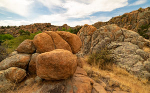
Orange Boulders
Orange Boulders – Lichen-covered granite boulders have weathered and fell off their tight-fitting stack.

A this week’s featured image shows, the trails of Granite Dells City Park provide diversity you wouldn’t expect to find in a massive formation of slow-cooled lava. This week’s featured image shows a small example of that. It comes from one of the Flume Trail’s spurs. Instead of walking around a ridge, this option climbed over it, before it descends and rejoins the main path on the other side. I’d call it a shortcut, but since it added a climb, it didn’t save any time.

On the ridge, the view opens, and since the granite pile tops were exposed to weathering longer than below, so more of the car-sized boulders lay scattered on the ground. If you’ve only driven by The Dells, you’d get the idea that the rocks are nothing but dirt. As you can see in this image, they’re actually covered with lichen of various colors. Here an orange species grows next to a green varietal. Up close, they give the rocks a velvety texture.

I stopped along the trail to capture this image because this tumbled pile of rocks stood apart from assembled puzzle stacks surrounding them. The distinct orange color caught my attention too. There are other colors that you’ll see as you walk along the trails. We’ll bee seeing some of those in other photos this month. Finally, I included a bit of the trail in this image to add a leading line and some perspective to the image.

You can see a larger version of Orange Boulders on its Web Page by clicking here. I hope you enjoy viewing my newest entry and come back next week when we show another photo from Granite Dells.

Until next time — jw

Dells Scrub Oak Picture of the Week

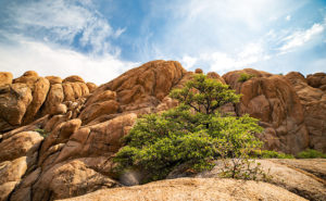
Dells Scrub Oak
Dells Scrub Oak – The green of a mature scrub oak stands out against the Granite Dells boulders.

This week’s featured image is one that I took while exploring the Flume trail that parallels Granite Creek below the Watson Lake dam. State Route  89 divides Granite Dells Park as it heads north out-of-town, with the Willow Lake complex on the west side and the Watson Lake facilities on the east. Each division has trails that meander through the maze of boulders. The main series of trails around Willow Lake is called the Constellation Trails. I’ve only had a taste of that trail system, but I want to hike there some more. I have hiked a couple of the trails around Watson Lake and I’ve completed the Flume Trail twice.

The trailhead is located along the north park boundary. Access to the parking area is via East Granite Dells Road. The trail is almost a mile long in each direction and has a couple of moderate climbs over a couple of ridges, but a lot of it is flat. At its start, it runs between private properties so you’ll see signs warning you to stay on the path. After the first hill, the trail drops into a wide grassy area where you walk creekside under a growth of Cottonwoods. There is a second ridge you must traverse before the trail returns to Granite Creek and stays there up to the dam. When water is high, excess water rushes out of a flume—sort of an artificial waterfall. The water has been low for several years, so the flume is rarely used.

We visited the Dells on our June Costco run, but I wasn’t ready and made a stupid mistake. We left home early so I could go shooting before the warehouse opened. I wanted to photograph with a low sun for the color and it was around half past eight when we got to the parking area, but the day was going to be hot—even in Prescott. While Anne waited in the shade, I grabbed my camera and a second lens and then headed up the trail without water. It was going to be a hit-and-run shoot lasting an hour, tops. I hiked this trail five years ago without problem when we spent the 4th in Prescott. This time I underestimated the strenuousness of the climb, the morning’s heat, and the extra two-thousand feet of altitude. By the time I stumbled back to the car, I was in such bad shape that I made Anne drive us to breakfast while I downed a quart of water. When we got to Costco, we bought a small backpack that I can carry camera equipment and a couple of bottles of water in. Live and learn, eh?

I came upon this scene at the trail’s beginning. After leaving the parking area and making my way over the first hill, I saw this scrub oak—a rather large and nicely shaped one at that—growing in the rock cracks. The green of its leaves stood out against the tan of the granite boulders towering over it. The wispy clouds made the blue sky interesting, so I included them in my composition.

You can see a larger version of Dells Scrub Oak on its Web Page by clicking here. I hope you enjoy viewing my newest entry and come back next week when we present another photo of the Granite Dells.

Until next time — jw