Shadows, Boulders, and Cracks Picture of the Week

Queen Anne and I had only ventured into the Bradshaw’s once before this month’s Senator Highway adventure. We borrowed a friend’s 4wd tow truck and wanted to see how well it performed on dirt roads. We decided to drive to Crown King for Sunday brunch. It was a horrible experience—lunch was nice, but the track was one long washboard. The truck bounced so much that it took a week for our eyes to stop vibrating. That was before Google Maps—actually, it was before computers—so we added another unnecessary 50 miles to the trip. Anne swore off dirt roads forever.

That’s too bad because the Bradshaws (named for trailblazer William D. Bradshaw) fascinated me since I moved to Phoenix. From the valley, they’re the high range to the north. When you head Flagstaff, they’re the first pine-covered mountains that you pass. The Sunset Point rest stop, which is at the range’s eastern flank, is where I feel that we’ve at last got past the city limits. Finally, during the summer monsoons, they create the storms that bring rain to the valley (as I look out my window today, I see what could be our first seasonal storm—and it’s moving south from the Bradshaws—if it gets here at all).

Whenever we’ve stopped at Sunset Point, and I had to wait for you-know-who to finish up in the bathroom, I always looked up at the mountains and mistakenly thought that they were dry and deserted. I’d think to myself, “It’s too bad there aren’t any fishing lakes up there.” On our recent trip, I found out that I was wrong because back roads lace through the range leading to former mining towns filled with summer cabins. There are even a couple of small lakes—but they’re so close to Prescott, I’d classify them as town lakes. Perhaps it’s just as well that there’s no destination up there, because if there were a big lake up there, then there’d be freeways and planned communities around it.

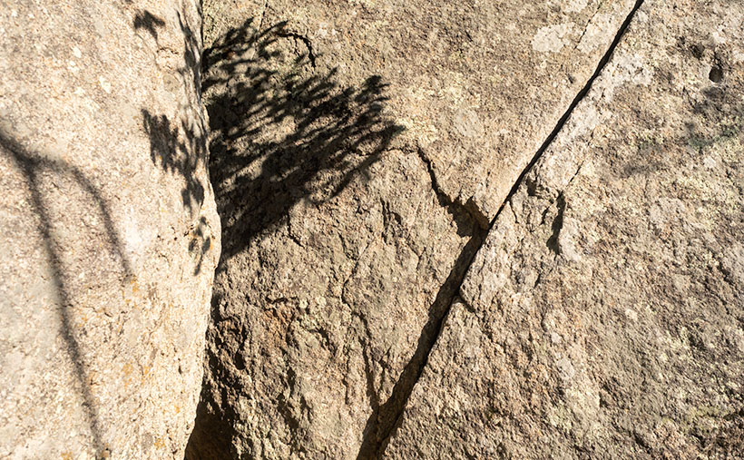
Shadows, Boulders, and Cracks - This is the simplest essence of what I found interesting about a pair of granite boulders south of Groom Creek, Arizona.
Shadows, Boulders, and Cracks – This is the purest essence of what I found interesting about a pair of granite boulders south of Groom Creek, Arizona.

As Anne and I continued exploring Senator Highway, we came across a boulder field south of Groom Creek. I find these large lumps of granite interesting, but they’re all over the state, and my rock collection is vast. I hear people say, “Meh. It’s another rock picture.” So, for this week’s featured image, I tried to show just the part that made me raise the camera to my eye. In the case of this week’s featured image, that I call Shadows, Boulders, and Cracks, it was the texture of the massive rocks, the delicate shadows of the deciduous trees, and the fracture that splits the right sphere in half. Even without seeing the entire boulder, you instinctively know that you couldn’t skip one of these pebbles across Goldwater Lake.

You can see a larger version of Shadows, Boulders, and Cracks on its Web Page by clicking here. I hope you like it. Be sure to come back next week when we present another image from the Senator Highway going south from Prescott.

Until next time — jw

Road Bend Picture of the Week

Although I’ve tried my best to hold back time, the season has changed,  and it’s summer again in the desert. Summer’s dog days are the worst time to be photographing our arid home. Except for the brief respite at either end of the day, the bright sun and ozone combine to wash the colors away. It’s like seeing the world through a 2% milk bottle—the glass ones, not the cartons. You need polarizing sunglasses to force the blue to show in the sky again.

We desert-rats are nothing if not adaptive. Like all of the other Sonoran critters, we hide in our holes during the day. For example, the Round-tailed Ground Squirrel escapes the day heat in his den by sleeping splayed-out on his back. I do the same thing, and I’d show you photographic evidence except I’d be banned forever from the Internet. The other thing we do is migrate. Even during this pandemic, Highway U.S. 93 was a parade of boats heading north towards the rivers and lakes on this holiday weekend.

When we were deciding on a project for July, Queen Anne and I followed a similar logic. We looked for someplace cooler—trust me, 90º is cooler than 110º. We scoured our maps for a place nearby in the mountains, a location that wouldn’t have crowds yet be accessible. We settled on the Senator Highway that runs from Prescott south into the Bradshaw Mountains.

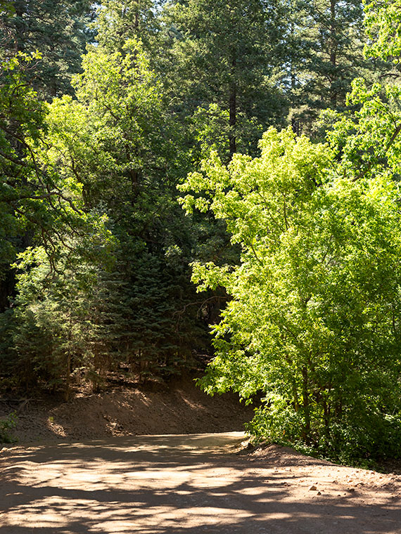
Road Bend - Bright yellow-leaved deciduous trees obscure what's beyond the road on the Senator Highway south of Prescott, Arizona.
Road Bend – Bright yellow-leaved deciduous trees obscure what’s beyond the road on the Senator Highway south of Prescott, Arizona.

Until this month, I didn’t know why there was a dirt road called the Senator Highway. I imagined that it was a route that our state assemblymen traveled when Arizona’s capital swapped several times between Prescott and Phoenix—foolish me. Instead, it’s just another mine road that the miners built it to transport ore and supplies between the Senator Mine and Prescott. If you’re skilled at navigating the Bradshaws, you can technically get to Congress via the Senator Highway.

I find the pine-covered mountains, like the Bradshaw’s, hard to shoot. The trees get in the way. I mean, how many different ways can you get an image of ponderosa pine tree bark? I hunt for edges—splashes of color, an opening to the horizon, or building ruins. That’s what I’m showing in this week’s featured image. At a bend on the highway, I saw some trees (I believe Arizona Ash) with bright yellow-green leaves shinning in the sun against the duller blue-green evergreens. I liked how they obscured the path. My mind wants to find out what’s beyond. It’s a classic leading-line perspective trick, and I find the dappled shade on the road a bonus. I named the first image for our July project Road Bend because it’s a simple title for a simple photo.

You can see a larger version of Road Bend on its Web Page by clicking here. I hope you like it. Be sure to come back next week when we present another image from the Senator Highway outside of Prescott.

Until next time — jw

Granite Mountain Picture of the Week

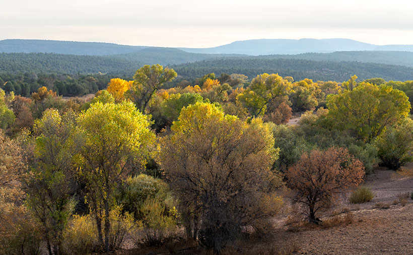
Fall on the Humphrey Wash- Usually the high-country aspen trees get all of the attention for their fall colors, but every so often, you can find some subtle color along the road.
Fall on the Humphrey Wash- Usually, the high-country aspen trees get all the attention for their fall colors, but occasionally, you can find some subtle colors along low-land roads.

This week’s featured image (below) is the last from our Camp Wood Road excursion. It was taken a few miles from the route’s junction with Williamson Valley Road—also known as Yavapai County Route 5. You’re still in the middle of nowhere when you arrive at that intersection. Iron Springs is 22 miles south, Seligman is 30 miles north, and all dirt roads. I’ve already made a note of it for a possible future trip.

From the Sheridan Fire area, I talked about last week, Camp Wood Road descends from the pine-covered hills and mountains into Prescott’s flat grasslands. It’s a natural location for the sprawling cattle ranches of the past, and now it’s the target of developers selling one-acre McMansions. When I traveled to this area as a younger man, I could frequently spot grazing antelope. They’re a rare sight these days, and that makes me sad.

When Queen Anne and I set off on this photoshoot, we spent more time getting to Camp Wood than I estimated. It was already after sunset by the time we reached the road’s end. As we drove in the dim light, I knew I wanted to include the open grassland in the Camp Wood story, so we made a second trip. This time, we drove counter-clockwise—which is more accessible and a much faster way to get there. However, on the second drive, the sky was overcast, and someone had set the Bradshaw Mountains ablaze, which filled the air with smoke. I wasn’t optimistic about getting good shots. As it turns out, the fire was only a controlled burn, and the fire crews had it out by the afternoon.

We found another change when we reached an area called Humphrey Wash on my maps. The broadleaf trees started turning color in the intervening weeks between our visits. Of course, this is Arizona, so they weren’t the bright colors you’d see in New England, but they were still worth getting out of the truck and getting them on film.

Granite Mountain
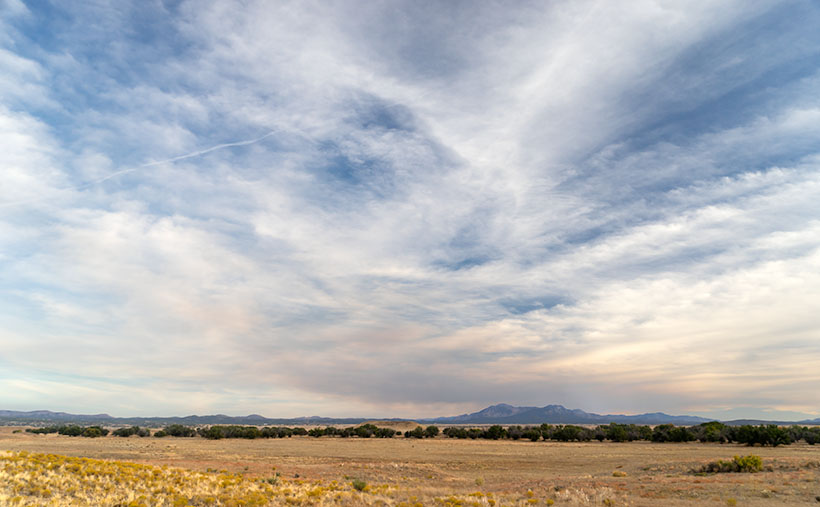
Granite Mountain – Under a vast sky filled with broken clouds with lingering smoke, Granite Mountain dominates the southern horizon from the Las Vegas Ranch in Williamson Valley.

Further east on Camp Wood Road is a large ranch with two driveways. It’s the Las Vegas Ranch, and one of the entrances is along Camp Wood Road, while the other connects to the Williamson Valley Road—a dozen miles away. When we arrived, the sun was low, the overcast began breaking, and Granite Mountain was predominant on the southern horizon. I took two versions of that scene, but I think the second was better because of the cottonwood trees lining an unnamed wash. I called it Granite Mountain, and I wanted to show the Prescott grassland’s open space. Just as it is in real life, the sky dominates everything. In this photograph are all of the elements of that visit: the broken clouds, lingering fire smoke, Granite Mountain, and the vast open plain. I hope you enjoy it.

Click here to see a larger version of Granite Mountain on its Web Page. I hope you enjoy viewing it. It’s the start of a new month next week, so we’re off to explore a different Arizona back road, so be sure to come back and see what we’ve discovered.

Until next time — jw

Tin Shed Picture of the Week

It was the fourth article about my time shooting pictures in Colorado’s San Juan Mountains when Queen Anne burst into my office—all akimbo—and began scolding me. “Fred and me this, and Fred and me that. I haven’t had press in a month.” I felt like the guy in that Toyota commercial trying to answer his wife’s question. “I’m sure there’s a right answer here.” I quickly flipped through my brain’s Rolodex of apology cards, before I realized she was right. I had to change tactics, “If you want press, you have to put your butt in the truck.” I had her.

Last week, I announced that I was leaving for one of my back-road photoshoots, and I wouldn’t be back until after dark. I packed my gear and went into the house to grab my cooler stuffed with water and snacks. When I got back to the garage and jumped into Archie’s driver’s seat, guess who was sitting shotgun? Yes—it was Her Highness.

Now that her ego is satiated, I can tell you about October’s topic. I picked out a back-road that goes from Bagdad to Williamson Valley—northwest of Prescott. On my Gazetteer map, it’s identified as Behm Mesa Road, but it had several other names as we drove it, like Camp Wood Road, Forest Service 21, or Yavapai County Route 68. The map says it’s broad and well-graded, so a passenger car should make it, but there are sections on Behm Mesa’s shoulder that are rough and rutted, so I’d feel more comfortable driving at least a pickup truck with some ground clearance.

The terrain starts in Bagdad with large boulder fields interspersed with grassy flats on the mesa tops. As the trail gains elevation, the trees change from scrub oak to juniper and ponderosa pine near the Santa Maria Mountains.  After that, the road descends into the open grasslands found around Prescott. There are a couple of cattle gates that you have to open (and close) as you cross private ranches. Most of the route’s middle section runs through the Prescott National Forest, including a part along the edge of last Augusts’ Sheridan Fire. It’s weird/unusual to see a healthy forest on the road’s north side while the south side is black and barren.

Tin Shed - An old corrugated tool shed along the Camp Wood Road.
Tin Shed – An old corrugated tool shed seen along the Camp Wood Road.

I took this week’s featured image near our starting point. As the road leaves Bagdad, you slowly travel on the shoulder of Behm Mesa—where the rough part is. September’s heavy rains may have been the cause of the ruts, and the county hasn’t regraded it. Shortly after it makes its way to the mesa’s top, you reach the first gate at a ranch house, with black cattle hanging around a water tank. Just past the tank was this tin shed in a golden grass field that had a nice contrast against the deep blue sky (opposites on the color wheel). You all know that old buildings—like this one—are a favorite subject of mine, so I had to get out and snap a picture. I call it Tin Shed.

You can see a larger version of Tin Shed on its Web Page by clicking here. I hope you enjoy viewing it. Next week, we’ll have another image to show from the drive that Queen Anne (she gets make-up press) took on the Camp Wood road.

Until next time — jw

Timberline Picture of the Week

Timberline
Timberline – The subjects of this image suggest that it is on a scale larger than it really is.

The wind was warmer than I expected at this altitude. Blowing on my back, it seemed to help push me along the John Muir Trail in California’s High Sierra’s. The Mt. Whitney Trail was only a half mile further when I stopped to snap this photo of massive granite formations along the tree line.

I just made all of that up. My chances of hiking those famous trails have long vanished, but this week’s photo has a sense of scale that could work with a fictitious story like that. I took this photo I call Timberline at the Granite Dells along with the others featured this month. It’s the angle that fools the eye so that you think you’re looking at a craggy mountaintop. The trees also play tricks with your sense of scale. They’re actually shrub-size like they were scale models of ones that are much taller—bonsai versions if you will, and the sheer drop in the lower left isn’t the hundreds of feet that it seems. It’s only a dozen feet over your head as you hike the Flume Trail to the park’s northern boundary.

The reason I included Timberline in this month’s set is that it distills the Granite Dells into three simple elements; massive rocks, trees eking a living in hostile conditions, and the changing sky over them. The photo speaks of weight—or mass—and it shows a time contrast of a changing sky and momentary life against the permanence of the weathered granite. The sky changes hourly while the trees will be different in a century, but the granite will survive the next millennia unaltered.

You can see a larger version of Timberline on its Web Page by clicking here. I hope you enjoy viewing this week’s post and come back next week when we start a new set of images from a new location.

Until next time — jw

Lime Lichen Picture of the Week

Lime Lichen
Lime Lichen – The main lichen growing in the Granite Dells is either orange or a pale green. Every so often, you’ll find a bright green patch such as this.

In last week’s post, I wrote how the Granite Dells boulders weren’t just bare rock, but they’re covered with living organisms which gives them color and texture. As you hike along the trails and take a closer look, you’ll find lichen, moss, fungi, and things that only a botanist could name growing there. Although they resemble a plant, lichen is a relitive of algae. They don’t put down roots, but instead, they get water and nutrients from the air. Lichen has a surprisingly long lifespan, but they don’t handle pollution well. When we were landscaping our Goodyear home, Anne and I specifically picked out some boulders that had a green specimen growing on them. Within six months, all the growth vanished.

There are two predominate colors of lichen in the Dells, an orange and another that is light green—seafoam if you will. Occasionally there’s a patch of a bright green specimen that catches the eye, and that’s how I happened upon this shot. The green was a small part on the larger rock surface, so to make it stand out, I moved in close enough and made it the subject of this photo. I like the way the bright green dominates the other muted colors. In all, I count four species growing in this shot. Because there’s not a structure in it, the abstract image is about color and texture. I call it Lime Lichen.

You can see a larger version of Lime Lichen on its Web Page by clicking here. I hope you enjoy viewing this week’s post and come back next week and see more from the Granite Dells.

Until next time — jw

Orange Boulders Picture of the Week

Orange Boulders
Orange Boulders – Lichen-covered granite boulders have weathered and fell off their tight-fitting stack.

A this week’s featured image shows, the trails of Granite Dells City Park provide diversity you wouldn’t expect to find in a massive formation of slow-cooled lava. This week’s featured image shows a small example of that. It comes from one of the Flume Trail’s spurs. Instead of walking around a ridge, this option climbed over it, before it descends and rejoins the main path on the other side. I’d call it a shortcut, but since it added a climb, it didn’t save any time.

On the ridge, the view opens, and since the granite pile tops were exposed to weathering longer than below, so more of the car-sized boulders lay scattered on the ground. If you’ve only driven by The Dells, you’d get the idea that the rocks are nothing but dirt. As you can see in this image, they’re actually covered with lichen of various colors. Here an orange species grows next to a green varietal. Up close, they give the rocks a velvety texture.

I stopped along the trail to capture this image because this tumbled pile of rocks stood apart from assembled puzzle stacks surrounding them. The distinct orange color caught my attention too. There are other colors that you’ll see as you walk along the trails. We’ll bee seeing some of those in other photos this month. Finally, I included a bit of the trail in this image to add a leading line and some perspective to the image.

You can see a larger version of Orange Boulders on its Web Page by clicking here. I hope you enjoy viewing my newest entry and come back next week when we show another photo from Granite Dells.

Until next time — jw