Bat Ears Picture of the Week

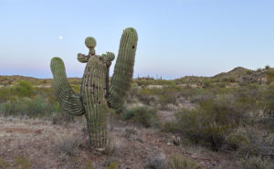
A couple of weeks ago, I drove to a part of Arizona that I hadn’t seen before. I knew about Alamo Lake as a fisherman but never went there because it wasn’t stocked with trout, and the fishing reports always warned about rattlesnakes. That was enough to put me off. But, during our club’s spring classes, one of the students brought in photos from the Alamo area that I found so interesting that I changed my opinion about visiting the La Paz County lake.

She took photos east of the lake, where Date Creek cuts through an ancient mud deposit. Because of how the intermittent water has eroded the soil, the place is known as Mud Cliffs. It’s not shown on any maps I have, but I knew it was the general area, so I left the house with enough time to explore and still have a couple of hours to shoot before sunset.

From Wenden, the paved road to Alamo State Park runs due north. It has little or no traffic, and it only took me an hour to get to the park store. When I asked the friendly staff inside about the cliffs, the host handed me a hand-drawn map. “Head toward Wenden to the Wayside Road, then jog over to Palmerita Road and follow it north.”

“Thanks,” I said as I took the map and paid too much for a Butterfingers candy bar and the park’s day fee—even though I was leaving.

During the classes, my student said her group was out on ATVs, but she believed you could get there by car. She was right. All the roads were wide and well-graded, and when I drove them, they didn’t have a lot of washboards. After I reached the spot on the map, I searched for the canyon shown in her pictures, and when I found it, I spent an hour or so hiking and shooting the photos that I’ll be sharing this month—I guess it’s Alamo Lake Month.

Bat Ears
An erosion formation at the head of the slot canyon glows in the late afternoon sun. The pair of points on top reminded me of a bat or maybe even Batman.

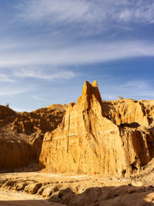
This week’s image is called Bat Ears, and I took it at the slot canyon’s mouth towards the end of the day. I passed it going in, but the sun didn’t have the same warmth as in this image, so it wasn’t interesting enough to shoot. The name comes from the pair of points at the top. This cliff doesn’t have a name—none of them do. Because the soil is so soft, it quickly erodes. A good flood will wipe out the existing landscape and replace it with new formations. The ears may not last another year, so I got to name a geological feature that—maybe—no one else will see. My chest swells with pride.

You can see a larger version of Bat Ears on its Web page by clicking here. I hope you enjoy viewing my new entry, and I hope you’ll tag along as I work my way up the canyon. It’s a pretty exciting hike.

Until next time — jw

Reach for the Sky Picture of the Week

I drove down past the Safeway into the Vulture Mountains last evening to do some photography. My intent was to capture an image of Vulture Peak shining in the sunset, so I drove around until I found an angle where I could get the image that I visualized and set up my camera. It didn’t work. From the spot I was shooting, it would work better as a sunrise shot. While at that scene, I saw this funny little saguaro on my right and decided to shoot it instead. I call it little, but even with its center trunk lopped off, it’s taller than I am.

Reach for the Sky
Reach for the Sky – A near-full moon rises behind a decapitated saguaro in the Vulture Mountains.

By the time I got set up for this image, the sun was down and it was already into the blue hour—the period after the sun has set but still light enough to see colors. It wasn’t until I began to concentrate on the saguaro that I noticed the near-full moon rising, so I’m going to toss it in for no extra charge. The cactus is interesting for a couple of reasons. Somehow it lost the top of its main trunk and it has sprouted new arms, of which one looks like a melon … or even a head if you have a vivid imagination. The second notable thing is that it’s still plump with water even though we haven’t had rain for months—which may be the reason it was able to generate the new growth. In any case, it has cool apartments for woodpeckers, cactus wrens, and maybe an owl family this summer.

I called this shot Reach for the Sky and you can see a larger version of it on its Web page here. I hope you enjoy viewing my new pico’-week and that you’ll tell me what you think. Maybe next week, I may get out of bed early enough to get a better version of my first idea.

Until next time — jw

April Sunset Picture of the Week


April Sunset
April Sunset – After a flat and dreary day, a weather front breaks up at sunset.

Life is full of ironies. After writing last week about sunsets, I spent most of Monday working in my wood shop. A weather front had moved in overnight and most of the day was flat and overcast. The disturbance brought snow to the high country but nary a drop of rain to the desert. It was a good day for working indoors. However, late in the afternoon, I noticed that Chuck and Kay’s house—our neighbors from across the street—was bathed in sunlight, which made me walk to our deck out back so I could see the western sky. I watched the clouds beginning to break up and leaving a clear sky behind them. From experience, I knew that meant that there would be a colorful sky once the sun dipped below the horizon. After writing a week ago that I have been too lazy to chase sunsets, I decided to make a lie of that comment, so I gathered my gear and when the time was right, I drove to a place where I had a clear view of the horizon. I took my time and recorded the psychedelic scene until it faded. Of the fifty images that I captured, I liked this one best and I call it April Sunset.

As opposed to the simple streaks of colors in last week’s photo, this one is about textures; all kinds of different textures. The streaks of yellow, the wisps of the pink cotton candy stand out against the single patch of blue. As I shot, there was color all around me, but there was only one area having a dark pile of cotton balls seen in the upper right and this was the shot best showing those lumpy edges as they grabbed the sun’s rays.

You can see a larger version of April Sunset on its Web page here. I hope you enjoy my new work. Tell me how you think it compares to Harcuvar Sunset, its predecessor?

Until next time — jw

Harcuvar Sunset Picture of the Week

There are good days and there are bad days. I have been out on photo shoots where nothing went right, and then there have been days when everything was perfect. This week’s photo is from one of my better days. Last week, I went on an expedition to Alamo Lake—a place I hadn’t visited before—because I saw a place in a student’s assignment that I wanted to photograph. I spent several hours driving to La Paz County and an hour searching for the right place. I spent another hour or two walking and shooting before I felt like I had what I wanted and packed up for the long drive home. As I got closer to home, the sun was setting and when I turned onto State Route 71, this was the view out of my door window so I pulled over to capture it.

Harcuvar Sunset
Harcuvar Sunset – After a day of shooting in the desert, I stopped on the drive home to take one last photograph.

I’m pretty ambivalent about sunset photos. They’re beautiful and all, but they’re everywhere. When I was younger I shot a lot of them, then I went through a period where I ignored them. Maybe I’ve mellowed in my old age because I feel like I’ve passed up some spectacular shots because I was too lazy to drive to an open field and I promised myself to rectify that.

This shot—called Harcuvar Sunset—is interesting to me because of the cloud layers. The sun’s last rays color the low clouds while the higher upper streaks are still white. The contrail—usually something that meddles in a photo—seems to be caught in the space between them. I captured this scene at the edge of an alfalfa field in Aguila and the mountains are the Harcuvar Range—I was shooting on the north side of them for most of the day.

You can see a larger version of Harcuvar Sunset on its Web page here. I hope you enjoy my new work and that you’ll tell me what you think. Do you think sunsets are beautiful or are they trite and overdone?

Until next time — jw

Yarnell Overlook Picture of the Week

For each picture of the week in this series, I normally select the best shots from the locations that I’ve written about. This week is a little different. I had to push back the scheduled image that I was going to use so I could insert a shot that I took yesterday. I intended to just shoot some test shots, but because this image fits into the current theme and because it came out better than expected, I decided to insert it into this week’s rotation. It’s called Yarnell Overlook named so because that’s where I shot it.

Yarnell Overlook  – The vista from the Yarnell Overlook takes in Fools Gulch in the foreground to Harquahala Mountain—fifty miles to the west.


I ordered a tripod part from Amazon that arrived Friday and I was anxious to put it to work, so I decided that I would ‘run up the hill’ at sunset and test it at the overlook. It was an easy place to get to and there’s little traffic there. During the day, I was concerned because of a boring cloudless sky and the winds kicked up a layer of dust making the atmosphere hazy. I resigned myself that the results would technically be OK,  so I didn’t expect more than that. As sunset approached, however, a few puffy clouds began forming near the Weavers which picked up my spirits. After dinner, I packed my gear into the car and set off for the pull-out located half-way up Yarnell Hill to conduct my test. The view from the overlook is most often hazy and the back-light from a setting sun is even worse for shooting a high detail photo.

After I processing the test, however, I think the results exceeded my expectations. Although the dust obscures the fine detail and acts, well … like fog adding some drama. I like it because of the afternoon clouds above the layer of dust. The viewpoint overlooks Fools Gulch with its working gold mine. The Stanton road that I wrote about for the last couple of weeks is just beyond the very large Parker Diary Farm that you can see in the middle-right. The last thing that is pleasing to my eye is the repeating round shapes of the boulder-covered foreground hill and Harquahala Mountain—some fifty miles away on the horizon. In case you’re curious, our house is located in a lighter patch of homes near photo’s center.

You can see a larger version of Yarnell Overlook on its Web page here. In last week’s post, I mentioned using a Like button. Fred correctly pointed out that when you follow the post links, there isn’t such a button. There are Like and Share buttons, but they are only on the blog’s homepage. To access that version, you need to first open my Webpage and click on the Blog link in the menu. That sounds like too much trouble, so I won’t bother mentioning them again. No matter which version you see, I hope you enjoy viewing my newest work.

Until next time — jw