Vortex Picture of the Week

Have you ever been to a place, but you didn’t know you were there until you went away? I know that sounds like a Yogi Berra-ism, but it will make perfect sense once I explain. Most of the time when I’m out shooting, I have to come back to the office and scour maps to name the landmarks that are in my pictures—and you thought I was a human geography book. That’s the story behind this week’s featured image that I call Vortex.

Vortex
Vortex-I was able to compose two photographs standing on the Boynton Pass Overlook. I found out later that it’s also the location of one of the four Sedona vortexes.

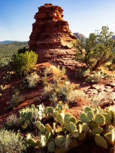
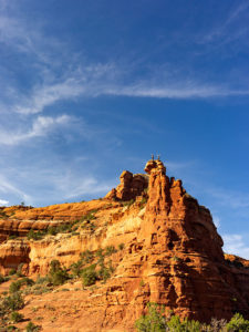
For Sedona month, I wanted to get images of the red rocks that aren’t on every calendar that you’ve owned, so I scouted and explored a couple of trails that were off the beaten path. One of them was the Boynton Pass Overlook Trail, and I took the Climbers photo featured three weeks ago from the same place. Back at the office, I searched Google Maps to see if the pinnacle they were scaling had a name. It didn’t (Wrong. According to the site in the following link, its name is Kachina Woman – jw), but—according to the map—I was standing on (or near) the Boynton Pass Vortex. When it comes to those kinds of metaphysical things, I must admit that I’m a skeptic, so I wasn’t searching for a vortex. I was after the view. It’s interesting that there isn’t a marker to show it’s there and I didn’t come away enlightened. I did, however, get two photos from one spot, so maybe …

This smaller turret and the much taller tower as seen in Climbers flank each end of the overlook saddle. Since they’re on opposite ends, if you look at one, you have to turn around to see the other. I liked the shape of this little guy—it kind of looks like an inverted tornado. I don’t know what a vortex looks like, so maybe this is one.

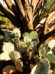
Another thing that appeals to me is the plants. Within the frame, are all the varietals that make up the Sedona chaparral: juniper, sage, prickly pear, agave, and some others that I can’t identify by name. I’d like to think that this shot is a miniature Sedona model—a stack of red sandstone and the plants thriving there. If I had a stag deer majestically posing in the photo, it would have been perfect—or maybe have it spinning through the air like the cows in the movie Twister.

You can see a larger version of Vortex on its Web Page by clicking here. I hope you enjoy viewing this week’s post and come back next week when we’ll start another month in a new site.

Until next time — jw

Prickly Juniper Picture of the Week

In a place like Sedona, with its canyons and red-rock buttes, it’s easy to get overwhelmed by abundant beauty. I can imagine a project where I simply recorded a catalog of the natural formations along Oak Creek, but that would make for a boring story. A good story changes pace and adds contrast. That’s why, as I scurry about hither and yon at a new site, I keep my eyes open for interesting things below my nose.

Prickly Juniper
Prickly Juniper – A prickly pear cactus grows in the sun beneath a dead juniper tree in Sedona Arizona.

This week’s featured image—called Prickly Juniper—is an example of looking for intimate subjects amidst spectacular scenery. I saw this prickly pear along the trail that I wrote about last week. If it were on its own, I probably would have ignored it, but it nestled under the bare branches of a dead juniper tree and together they caught my attention. I liked the light against the dark, the living against the dead, and the prickly pear’s circular pads against the tree’s linear branches. The late afternoon sun was showing off the tree’s texture and the cactus’ lethal thorns. I took a couple of variations of this image and I felt this version was the best.

You can see a larger version of Prickly Juniper on its Web Page by clicking here. I hope you enjoy viewing this week’s post and come back next week when we’ll present another featured image from Sedona.

Until next time — jw

Climbers Picture of the Week

This week’s featured image was shot in Boynton Canyon on Sedona’s west side, north of State Route 89A. It’s the site of The Enchantment Resort—a very high-end destination requiring deep pockets to stay there. There are several trails in the canyon that meander among the cliffs and buttes, and that’s exactly what I was searching for. In the parking lot, the map said that I had a choice of three routes: one that went to a dead-end up the canyon, a second longer trail over Dead Man’s Pass, and finally a short hike to a canyon overlook. I’m all for short and I’m adverse to dead men, so I set off for the overlook.

The trail is fishhook-shaped as it skirts the south side of an outcrop then turns 180° and ascends into a saddle, wedged between the outcrop and a larger butte. It’s only a quarter-mile long, but the rise got tricky in a couple of sections. It’s good that it was well-marked with white paint splotches. The climb doesn’t seem much until you reach the saddle and turn around and see the valley floor a couple hundred feet below. To the west is a great view of the resort nestled among the red-rock cliffs.

As I clambered up the hill, I stopped a couple of times to rest and clear the heart beating in my ears. When I could hear again, there were voices, but I couldn’t see anyone on the trail above or behind me. It wasn’t until I reached the saddle that I saw a pair of climbers—a woman and a man tethered together with a rope—as they were nearing the butte’s summit. I assumed that she was leading as she was higher and coaching his assent.  “Cool,” I thought.

Once I reached the saddle, I set up my tripod and camera and began shooting all the compass points, and savored the water I remembered to bring. After I completed my long-shots, I started a series of close-ups with the camera hand-held. I could tell from their voices that my climbers had reached the top and were taking in the view.

Climbers
Climbers-A pair of rock-climbers celebrates success atop a Sedona Butte.

I thought about photographing them while they were enjoying their success, so I yelled up to them, “Hey! Can I get a shot?”

They were so polite. They hunkered down out of sight. “No,” I shouted again, “I want to shoot you on top.” When they stood up, I pantomimed celebration by raising my hands in the air. They followed my instructions and even began whooping. I fired off a couple of frames and shouted “Thanks” to them and then began to make my way back down to the truck.

I like the way the shot Climbers turned out even though they don’t take up a lot of frame space. As an Alaska guide once instructed us, “Humans are easy to spot. They’re the only thing standing erect.” In the image, I wanted to show their difficult conquest so I didn’t bother with a long lens. I also like the way the red sandstone contrasts against the dark blue sky and streaky cloud so I included more of it in the composition.

You can see a larger version of Climbers on its Web Page by clicking here. I hope you enjoy viewing this week’s post and come back next week when we’ll show another featured image from Sedona.

Until next time — jw

Red Toadstool Picture of the Week

There’s a place on US 89 about halfway between Page, Arizona and Kanab, Utah where the road gets lost. As you know, odd-numbered routes run north-south, but this section of 89 goes east-west for 60 miles between the two towns and right in the middle the road hits all the compass points. There’s a perfectly logical reason they built the road this way. This is where US 89 cuts through the southern part of the Grand Staircase Escalante National Monument, and with three cliff tiers in front of you, it’s just easier to go around them.

The explanation for the five-mile section of looping road is the same. This is when the highway crosses a rift valley and climbs around to the north side of Buckskin Mountain. This is also the spot on the map that is a landscape photographer’s Mecca. You have probably seen photos of exotic geological features and wondered where they were taken. Places like The Wave, White Outcrops, Paria Canyon, Buckskin Canyon, Calico Mountain, and The Toadstools are all within fifteen miles from the road. The bad part of that—for us geezers—is that you must hike that distance to get to them.

This week’s featured image only required a jone-mile hike, but it involved a climb to a shelf 300 feet above the road. Once you make it, you’ll find a group of toadstools—columns of sandstone supporting a protective capstone. Although the trail up there isn’t flat, you don’t need to be an élite climber to make it. Queen Anne got far enough that she was able to watch her hero snap this photo, which filled her with so much emotion that she had to return to the car and do her nails.

Red Toadstool
Red Toadstool – A protective capstone is supported by a column of red sandstone near Kanab Utah.

I shot this toadstool from a couple of angles and after viewing the test strips back at camp, I preferred this version even though it’s smaller within the frame. The composition is stronger, and the image is uncluttered, so the formation becomes a stronger subject. The light wasn’t what I envisioned when I planned this trip, but the thunder clouds are kind-of cool. I call this image Red Toadstool and I’m pleased to start a month of Utah photos with it.

You can see a larger version of Red Toadstool on its Web Page by clicking here. I hope you enjoy viewing this week’s post and come back next week when we present another image from a different Utah site.

Until next time — jw

Dells Scrub Oak Picture of the Week

Dells Scrub Oak
Dells Scrub Oak – The green of a mature scrub oak stands out against the Granite Dells boulders.

This week’s featured image is one that I took while exploring the Flume trail that parallels Granite Creek below the Watson Lake dam. State Route  89 divides Granite Dells Park as it heads north out-of-town, with the Willow Lake complex on the west side and the Watson Lake facilities on the east. Each division has trails that meander through the maze of boulders. The main series of trails around Willow Lake is called the Constellation Trails. I’ve only had a taste of that trail system, but I want to hike there some more. I have hiked a couple of the trails around Watson Lake and I’ve completed the Flume Trail twice.

The trailhead is located along the north park boundary. Access to the parking area is via East Granite Dells Road. The trail is almost a mile long in each direction and has a couple of moderate climbs over a couple of ridges, but a lot of it is flat. At its start, it runs between private properties so you’ll see signs warning you to stay on the path. After the first hill, the trail drops into a wide grassy area where you walk creekside under a growth of Cottonwoods. There is a second ridge you must traverse before the trail returns to Granite Creek and stays there up to the dam. When water is high, excess water rushes out of a flume—sort of an artificial waterfall. The water has been low for several years, so the flume is rarely used.

We visited the Dells on our June Costco run, but I wasn’t ready and made a stupid mistake. We left home early so I could go shooting before the warehouse opened. I wanted to photograph with a low sun for the color and it was around half past eight when we got to the parking area, but the day was going to be hot—even in Prescott. While Anne waited in the shade, I grabbed my camera and a second lens and then headed up the trail without water. It was going to be a hit-and-run shoot lasting an hour, tops. I hiked this trail five years ago without problem when we spent the 4th in Prescott. This time I underestimated the strenuousness of the climb, the morning’s heat, and the extra two-thousand feet of altitude. By the time I stumbled back to the car, I was in such bad shape that I made Anne drive us to breakfast while I downed a quart of water. When we got to Costco, we bought a small backpack that I can carry camera equipment and a couple of bottles of water in. Live and learn, eh?

I came upon this scene at the trail’s beginning. After leaving the parking area and making my way over the first hill, I saw this scrub oak—a rather large and nicely shaped one at that—growing in the rock cracks. The green of its leaves stood out against the tan of the granite boulders towering over it. The wispy clouds made the blue sky interesting, so I included them in my composition.

You can see a larger version of Dells Scrub Oak on its Web Page by clicking here. I hope you enjoy viewing my newest entry and come back next week when we present another photo of the Granite Dells.

Until next time — jw