Winter Castle Picture of the Week

The KofA Wildlife Refuge takes up a good chunk of land. It covers a megabyte—or 1040 square miles if you’re not a computer nerd and don’t get the joke—nearly the size of Rhode Island. The topography is Basin and Range, which is standard for western Arizona, Nevada, and California’s Mohave Desert. Finally—one last bit of trivia before I move on from statistics—the wildlife range spans three mountain ranges (that’s three more than in Rhode Island).

Winter Castle
Winter Castle – The Castle Dome Range, south of King Valley, is back-lit by a low winter sun.

The reason for so much space is to support herds of desert bighorn and antelope. Fifty years ago, both of these large animals were almost gone. Like bison, the sheep were plentiful in western Arizona, but a century of overhunting took its toll. It’s actually the sheep’s fault. They walk to the edge of a precipice then strike a magnificent pose saying, “Go on and shoot. I won’t move, and I’ll bet you’ll miss.” It was a living shooting gallery. By the time Arizona was a state, they were effectively wiped out.

Things started to change in 1933 when the Boy Scouts worked to get a game range established. Although the idea seems convoluted, you can’t hunt big horn without having sheep—the very logic that started the conservation movement. The game management people augmented the herds with transplants from other areas—including Mexico, but there was too much inbreeding. To successfully reintroduce them, they needed a broader gene base with multiple herds. Wildlife scientists established a crowd in the KofA and a southern pack in the Castle Domes and another in the New Water range to the north. To make this system work young males need to migrate across the open desert between ranges and breed with a different stock. Sheep can’t move freely across an Interstate Highway. Now you know why the KofA management area is so large. We like sheep, however rattlesnakes are a different thing.

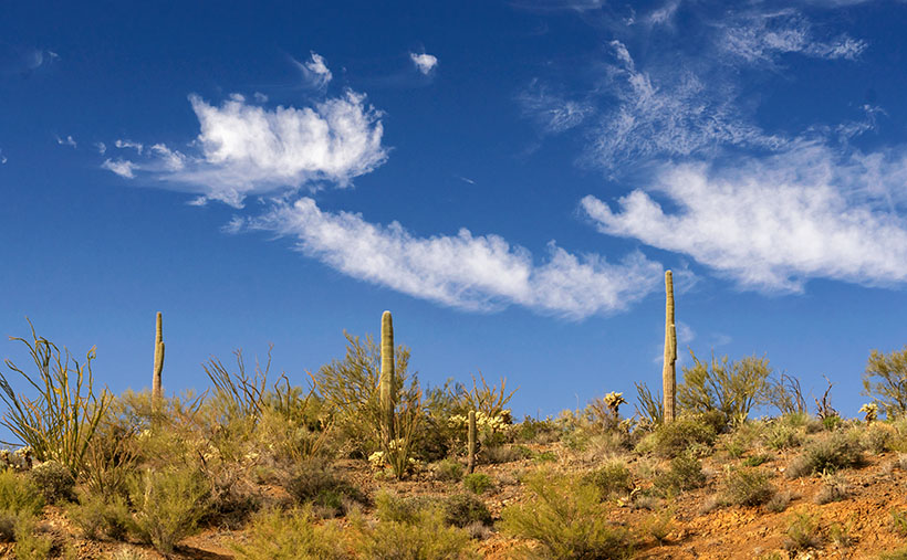
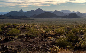
When I set up to photograph this week’s featured image, none of what I told you was in my head. I thought it was pretty. That’s all I need to take a picture. I made it late in the day while driving away from Palm Canyon looking south. On the far side of King Valley, the Castle Dome Mountains are back-lit from the low winter sun. The atmospherics show off the range’s depth, as the peaks progressively get lighter in the distance, with Castle Dome Peak rising to 3788 feet. As I processed this image, I began to understand its story. I called it Winter Castle, and I hope you like it.

As usual, you can see a larger version of Winter Castle on its Web Page by clicking here. I hope you enjoy viewing this week’s post and return next week when we’ll show another featured image from the KofA Wildlife Refuge.

Until next time — jw

Pair of Threes

I’m all alone this week because Queen Anne has gone home to her sister’s because they made Christmas cookies this week, and Anne goes where the sugar is. For me, it’s good news and bad news. The good news is that the bleeding from my ears has stopped since the yelling ceased. The bad news is that I don’t have a copy editor this week, so this will be a short post. I don’t know how to spell all the big words she uses. She’s coming home on Thursday so things will be back to normal then. Pray for me.

Meanwhile back at the mines—or more specifically, San Domingo Wash where Anderson Mill is.

Back in the days when everybody used film—that’s the cellulose stuff you put in cameras to capture images before we used electrons—I was a stingy shooter. Because each frame cost a buck (sheet film was five-times that), I wouldn’t waste my money on something I wasn’t sure was good. Now that electrons are cheap (and the prices keep falling), I’ll snap just about anything that catches my eye. Often that shot turns out to be junk, but one out of a thousand deserves a second look. That’s how this week’s featured image happened.

Pair of Threes -Three saguaro along the ridge overlooking the San Domingo Wash where the Anderson Mill is. The three wispy clouds make up the pair.

If you’re the kind of person that lingers on every word that I write, you’ll recall that in my previous posts that the Anderson Mill structure is several stories tall and that the brothers welded it together as needed. In the short time that Fred and I were there, I wanted to poke around the different levels. Now, there are steel-treed stairs, but most of them didn’t have handrails. So I walked the truck paths that snaked up the hillside. It was at one of the switchbacks that I looked up and saw three saguaros along the ridge. Without thinking, I snapped the camera shutter and then dismissed it. When I saw that image on the computer, I knew I could use it because the clouds made the photo. I call this image Pair of Threes.

You can see a larger version of Pair of Threes on its Web Page by clicking here. I hope you enjoy viewing this week’s post and come back next week when we’ll show another featured image from San Domingo Wash.

Until next time — jw

BTW: Anne’s flight comes in after 11 pm. If you were a good friend, you’d pick her up … and keep her.

Retaining Wall

There are hundreds—if not thousands—of abandoned towns and mines in Arizona. Most of them don’t have much to offer, because all of the things of interest have been taken away. As I pointed out in last week’s post about Anderson Mill, the good stuff has already been salvaged. In Arizona, there are about ten ghost towns, like Jerome, Bisbee, and Oatman where the residents were able to transform their community into a tourist destination, but the majority of them have returned to nature, and you’re lucky to find a concrete slab.

Retaining Wall - A retaining wall at the Anderson Mill made from surplus Army landing pads and steel plate.
Retaining Wall – A retaining wall at the Anderson Mill made from surplus Army landing pads and steel plate.

 Last week’s adventure to Anderson Mills is an example of my point. I would have been delighted if the sheds, trucks and other equipment remained on site. Alas, that’s not the case. At least the main-processing structure was still standing, probably because it was welded together and pirates couldn’t easily strip them. From what was left, I even got an idea of how the Anderson brothers cobbled together the plant with scrounged parts and probably no plans. My dad worked like that. He figured it out in his head and would slap things together. I should ask Fred—who’s a certified nuclear welding inspector—what he thought of the fabrication.

As I was shooting, I looked for strong elements of design; colors, patterns,lines—that sort of thing. As we were ready to make the trip home, I didn’t havemuch time to spend behind the camera. The most color that caught my eye rightaway was a retaining wall, built out of Army landing pads. The mica processingplant is gravity feed and sits maybe 50 feet above the bed of the wash. To makea level base up there, the Andersonsbuilt a reinforced embankment wall out of panels and then back-filled it withrubble.

When I took this picture of the week, I focused on the panels that had alternating yellow color values. I like that against the rusty steel corner plates. However, I didn’t notice the narrow gauge mine-car tracks holding the bottom together. It seems like an expensive piece of scrap metal compared with the other building materials used. I like the abstract feeling of this image, and I call it Retaining Wall. 

You can see a larger version of Retaining Wall on its Web Page by clicking here. I hope you enjoy viewing this week’s post and come back next week when we’ll show another featured image from San Domingo Wash.

Until next time — jw

Rusty Bolt Picture of the Week

♬ Get your kicks ♪
On Interstate 40 ♫

Well, that didn’t work; it’s not musical and doesn’t even rhyme. I suppose I shouldn’t try to mess with Bobby Troup’s song. I haven’t any musical talent anyway. My grandmother repeatedly told me, “You couldn’t carry a tune in a bushel basket.” The only thing I can play is the radio … while I’m driving, and when I drive across northern Arizona, that 1946 song inevitably pops into my head. Everybody from Bing Crosby, Chuck Berry, to the Cramps, have recorded it, so the tune has legs.

Rusty Bolt
Rusty Bolt-The Rusty Bolt drags bus-loads of tourists into the saloon to try their signature cocktail-a Rusty Bolt. I assume it’s a Rusty Nail in a bigger glass.

The reason that song has become an earworm in my brain is that Queen Anne and I drove two and a half hours to Seligman for this month’s photo shoot and we never left Yavapai County. For fifty miles, Route 66 runs along the northern border of our county—from Yampai to Ash Fork—and Seligman is at the west end of the most extended active section.

I’ve already recalled some of my personal experiences traveling cross-country on US 66, so I don’t want to be your grandpa continually retelling the same stories. But for the next generations, I’ll summarize some of the road’s highlights. Completed in 1926, U.S. Route 66 was one of the first paved highways across the west. It ran from Chicago to Santa Monica and provided an economical alternative to train travel. It was known as the Will Rodgers Highway, Main Street America, and the Mother Road. During the Dust Bowl and Depression era, thousands of migrants traveled west on the highway in search of a new life, a story that John Steinbeck captured in his epic novel Grapes of Wrath. My generation grew up watching Route 66 on a black and white 17” TV. The show’s two male characters—Martin Milner and George Maharis—traveled across the country in a Corvette. Their travels involved but weren’t limited to 66, and no one questioned their sexual orientation back then. The show turned the highway into a symbol of escape and adventure and permanently linked the Corvette to Route 66. (Incidentally, the show’s theme song made Billboard’s top 30 list.) The building of the Interstate System killed Route 66. The freeways went around towns and eliminated stop lights and speed traps. Without Federal money, states abandoned the road and began digging it up.

Angie's Chair
Angie’s Chair – Angie (cardboard cutout) and his wife-Vilma-founded the Route 66 revival movement from his Seligman barber shop and pool hall. I wanted to get my hair cut, but he was home sick with the flu.

In 1978 when Interstate 40 opened and bypassed Seligman, the town’s commerce disappeared, and that put the town’s existence in jeopardy. But the town’s barber administered CPR. Angel Delgadillo met with representatives from other affected communities, and they formed an organization to turn things around. They worked to make the old US 66 a Historic Highway. Within a year, the association successfully lobbied the Arizona State Government to declare the section between Kingman and Seligman a Historic Highway, with parts from Ash Fork to California added later. After that, other states followed our example, and they tagged sections of the remaining road as historic.

The nostalgia caught on, and soon gift shops were selling Route 66 kitsch and memorabilia. Each year, the Historic Route 66 Association organizes a Fun Run. On the first weekend in May over 800 cars gather in Seligman for a car show in the morning before driving en masse to Kingman for the night. The next day, they continue to Needles. Most of the participants are of my generation and are driving cars they wish they had in high school. 2019’s annual run will be the 32nd year.

On our Seligman visit, we saw several businesses competing for customers by displaying memorabilia and vintage cars out front. Of the samples we saw, this one stood out. It’s the Rusty Bolt Saloon and—along with the signs and flags—they added mannequins to their building. I’ll tell you that when you drive by, you think there’s a wild party going on here. I took this shot early in the morning as the sun came up and I liked how the statues stood out in the sun. The other advantage to shooting that early is the lack of tour buses parked along the sidewalk.

You can see a larger version of Rusty Bolt on its Web Page by clicking here. I hope you enjoy viewing this week’s post and come back next week when we return to Seligman and more photos.

Until next time — jw

Perry Mesa Needle Picture of the Week

Perry Mesa Needle
Perry Mesa Needle – This needle is at the edge of Perry Mesa above Black Canyon City. It’s new to me because it’s hidden from the freeway.

Phoenix only has two interstates that will get you the hell out of Dodge; Interstate 10 which either takes you west to California or east to everywhere else, and Interstate 17 going north. Driving I-10 in either direction always seems like a dreary, endless drive through the desert, while I associate I-17 with good times, like playing in the snow or—during summer—just escaping the heat. I think it’s because of all the different climate zones it goes through, like the desert, grasslands, riparian, and alpine forests.

The first change that you come to when heading north is the grade at Black Canyon City. It’s an abrupt transition from the Sonoran Desert to riparian grassland—saguaros are at the bottom, and they’re not at the top. It freezes more often at higher elevations, and the giant cacti can’t tolerate it. Black Canyon City is distinguished by being the northern edge of the Sonoran Desert; I know that because it says so on their welcome sign.

Most Phoenicians consider Black Canyon City a suburb populated with free-spirited residents. It’s the bottleneck on the highway where heavily ladened trucks insist on passing one another up the steep grade, or traffic is backed up to Prescott because a crash closed the freeway and there’s no other way around. During heavy rain, the community makes the news because the Agua Fria River floods and people get trapped in their homes or cars. If you do stop in town, it’s to get a slice of pie at its famous restaurant. I wouldn’t be surprised if most Phoenicians didn’t know Black Canyon was in a different county—Yavapai. I know that I didn’t, and that’s why I chose Black Canyon City as my place to look for October’s art.

I saw the subject of this week’s photo as I was driving around town. I-17 divides Black Canyon City in two. The business district is on the freeway’s west side while on the east is mostly residential and a few light industries. The needle can be seen on the east side but not from the interstate. That’s why I didn’t know it was there. It’s like a smaller version of Weaver’s Needle in the Superstitions, but as much as I searched, I couldn’t find its name. There was nothing on my topographic maps, highway maps, the Gazetteer or the city’s website. I saw this neat YouTube drone video, but it doesn’t list a name either. It’s on the southwest corner of Perry Mesa (sounds like an excellent name for a lawyer, doesn’t it?) where Squaw Creek runs into the Agua Fria River, so I used that moniker for the photo’s name—Perry Mesa Needle.

In this image, I like the way the low clouds and their shadow frame the subject. The grove of saguaro midway up adds scale to the outcrop. Finally, the recent rains cleared the air and gave me a deep blue sky making the puffy white clouds seem to pop in 3D. As was the case with the Jerome Hollyhocks a couple of months ago, if you know this needle’s name, please email me.

You can see a larger version of Perry Mesa Needle on its Web Page by clicking here. I hope you enjoy viewing this week’s post and come back next week when we’ll feature more from Black Canyon City.

Until next time — jw