Big Horn Tank Picture of the Week

We’re down to the final month of this gawd awful year. For one, I will be happy to get my vaccination and venture back out into the world again—well, right after you get yours, and I see that you don’t get sick and die from it. I’m afraid that it’ll be months before it’s my turn because I’m too young and pretty. So, because it’s a short month, and Queen Anne has abandoned me, we’re going to explore a road that’s both close by but too expansive to cover in one day.

This month’s focus will be on a road, unlike what we’ve covered on this platform before. It’s not even dirt. It’s a road that stretches from Jacksonville, Florida to Santa Monica, California. It’s also the longest possible way to cross Texas. When Anne and I visited Deb and Fred in Austin several years ago, I was dismayed to see a highway sign that said our destination was further off than the two states through which we’d already driven. I’m, of course, talking about Interstate 10.

Calm down, we’re not going to do the whole thing in one month, and I’m not ready for a lifetime commitment (ask Anne). For December, we’re going to point out the landmarks that I enjoy seeing between Phoenix and the Colorado River. Even with that limitation, there are too many to fit into four Sundays. We’re not even heading in a particular direction; we’ll talk about each place as I get to it.

If you’re like me, you loath driving cross country on the Interstates, but they are the most efficient route when your time is limited. I’ve made countless trips between Los Angeles and Phoenix since moving here a half-century ago, and the flat desert always was the worst grind—river, flat, mountain, flat, mountain, flat, town. After I learned some about the mountain ranges, it was more enjoyable to know that Courthouse Rock was coming up on the south side or that I could spot the abandoned solar observatory on top of Harquahala Mountain. It was like saying, “Hi” to old friends as we passed.

This week’s featured image was taken in the Tonopah area. From east to west, you’ll pass the Palo Verde Nuclear Generating Station, stop at Tonopah Joe’s for gas and heartburn, then on the north side of the highway—where Salome Road crosses—there’s a prominent horn mountain, called Big Horn Mountain. It’s the centerpiece of a wilderness area that’s the same name. Actually, there are two wilderness areas separated by a dirt road that I’ve yet to discover. These are the Big Horn Mountains Wilderness and the Hummingbird Springs Wilderness across the street. You can do backflips across the road from one to the other.

On the plains south of Big Horn Mountain Wilderness Area, is a rusty tank meant to provide water to cattle on the open range.
Big Horn Tank – On the plains south of Big Horn Mountain Wilderness Area is a rusty tank meant to provide water to cattle on the open range.

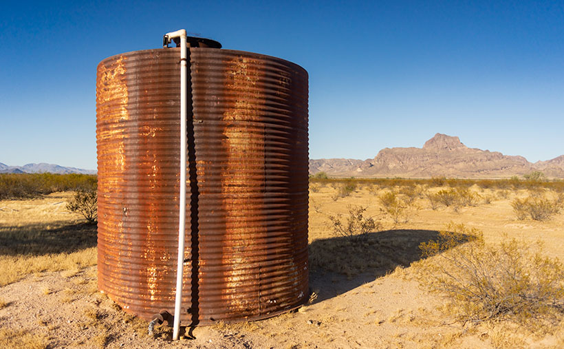
This week’s featured image that I called Big Horn Tank was taken from the Harquahala Plain off of the Salome Road. There on the open range, I found a rusty water tank for an interesting foreground. I think that rust is a photographer’s favorite color, and I like how the white PVC pipe accents the tank. The other thing I see is how little vegetation cattle have for grazing. They don’t eat creosote (would you), so they only munch on the yellow grass.

You can see a larger version of Big Horn Tank on its Web Page by clicking here. Be sure to come back next week for another roadside landmark from Interstate 10. Tomorrow, I have to phone the Queen to see where I’m allowed to go. Wait till I tell her what happened to me as I was leaving Algodones yesterday—she’ll never let me out of the house again.

Until next time — jw

Fish-Hook Barrel Cactus Picture of the Week

When you hear someone talk about a desert, what image pops into your mind? Is it the endless Sahara dunes where Bedouins in keffiyeh headdress travel by camels? Maybe it’s the barren, dry lakes of Death Valley, or perhaps your go-to desert is in Mongolia. By definition, a desert is any place receiving less than 20 inches of annual precipitation. That makes most of the Great Plains, most of Southern California, and the Antarctic deserts.

My desert is the one that I’ve called home for almost 50 years; the Sonoran Desert. In the last half-century, I’ve traveled most of its parts within Arizona and California. I can attest that it’s not a flat, uniform wasteland—as some people think. It has mountains, canyons, plains, dry washes, and an exotic river or two. Its span ranges between Arizona and the Mexican State of Sonora. If you see a map of it (and you have to squint real hard), it’s jellyfish shaped—starting at the north (where I live), the half-circle body covers Arizona, and the tentacles reach south to either side of the Sea of Cortez. Its width covers from El Centro to Tucson.

The signpost that says, “This is the Sonoran Desert,” is the saguaro cactus. It thrives here because of the four major western deserts; the Sonoran is the only one with two rainy seasons; winter rains and summer monsoons. In winter, the rains nourish the cactus to flower and bloom, while the monsoons provide water for the dispersed seeds to germinate. Isn’t nature swell?

Although the saguaro may be the Sonora’s big-ticket item, it isn’t the only thing here to see. That’s evident when you visit the desert’s reserves like Saguaro National Park, Organ Pipe Cactus National Monument, KOFA Wildlife Preserve, or several wilderness areas in southern Arizona. The biodiversity of these places will keep you on your toes—“Watch out! There’s a snake over there.”

Fish-hook Barrel Cactus - a couple of succulents nuzzle in the late afternoon sun.
Fish-hook Barrel Cactus – a couple of succulents nuzzle in the late afternoon sun.

That’s how I thought I’d end our one-day tour of Saguaro National Park. While exploring the park’s dirt road loop, I spotted a couple of succulents nuzzling one another, so I went in and grabbed a shot. I call this picture Fish-hook Barrel Cactus. It shows a couple of common cacti—a fish-hook barrel and prickly pear—glowing in the evening sun. The barrel cactus is the one you’re supposed to cut open if you need water—it’s not hollow, so you have to wring the pulp if you’re desperate for a bad tasting drink. Prickly Pear grows everywhere and has even overrun Australia after it was illegally transplanted there.

You can see a larger version of Fish-hook on its Web Page by clicking here. For December, we have an idea for a completely different type of monthly project. We had to. I’ll be spending time with my Mexican dentist—oh joy—and Anne is risking her life to visit her family. She’s shortening my leash while she’s away, so I won’t be able to roam very far from home. If I do, my electronic collar will shock me.

Until next time — jw

Arm Pits Picture of the Week

When we visit national parks, Queen Anne and I like to spend time at the visitor’s center. We study the 3D display map and look through all the books. It gives us an idea of what to expect. Unfortunately, one of the regrettable effects that COVID 19 has brought is that the centers are closed. Even so, we stopped at the one in Saguaro National Park because they leave literature outside for crazy folks like us. That’s where the story of this week’s picture begins.

After picking up a map, I wandered the grounds looking for a shot of the mountains outback. I took several shots, but I knew they weren’t keepers. We got back in the truck, intending to explore the open roads, but we never left the parking lot. I spotted a possibility and immediately parked. As I hiked up the hill, I spotted a unique saguaro, and I forgot all about what I was after. Ooh, squirrel.

Arm Pits - A close-up photo of a cactus that refused to shave found in Saguaro National Park, Arizona.
Arm Pits – A close-up photo of a cactus that refused to shave found in Saguaro National Park, Arizona.

Like people, saguaros are all different. Young ones have no arms; some have one arm, others two or more. Someone could publish a book of saguaro portraits—it’s probably already done. The specimen that caught my eye had multiple arms, and they were pretty much at the same level. It reminded me of the Hindu goddess Durga—the woman seated with a gold headdress and many arms. As I approached the cactus, I noticed that it hadn’t been marred with woodpecker holes, so I spent some time trying to get a memorable photograph.

When I first reviewed this shot on my computer, I came up with a litany of Queen Anne jokes about shaving her legs. They involved ruined pantyhose, scratching posts, bear fur, velcro, and things along those lines. But, this morning, I thought better and decided not to go there. It’s better not to squander what little life I have left. I didn’t want to let the humor go to waste, though, so I titled this shot Arm Pits.

You can see a larger version of Arm Pits on its Web Page by clicking here. Next week, our day in Saguaro National Park turns to late afternoon, so be sure to come back and see what we found.

Until next time — jw

Tucson Mountains Sunrise Picture of the Week

I woke up in a very chipper mood this morning. When I put on my jeans, they were so loose that I had to tighten my belt a notch to make things better. My morning routine is to check my vitals before making coffee, and my blood pressure was perfect today. There’s been a great weight lifted off my shoulders, and let me tell you what I think it is. First of all, I finally finished the wood project that’s kept me busy all summer—I’ll show you on Wednesday—and secondly, summer’s finally over—well I hope it is.

Over the past couple of days, clouds have filled the Congress skies, and it sprinkled Friday evening. That’s the first precipitation in months. This morning, our new wall thermometer got below 40º for the first time, and I got to put on one of my bulky sweaters. It keeps getting better—today’s forecast is for snow in the mountains. Yep, straight from summer to winter. Today, the world is better.

My mood is so good; I don’t have any snarky stories about Queen Anne, so let’s go back down to Tucson and see where we stopped for our second November image. Last week, we visited the overlook at the top of Gates Pass before dawn. Believe it or not, I wasn’t the only photographer there. A handful of guys were hanging out with their tripods set up for a sunrise shot when I got there. I’m not usually late to one of these parties, and when I saw what they were getting ready to shoot, I wasn’t impressed—it was more of a sundown kind of shot. After snapping a few other scenes, I hopped in the truck and headed down the road stopping again at the bottom of the pass.

Tucson Mountain Sunrise - The morning sun shines on top of the Tucson Mountains.
Tucson Mountain Sunrise – The morning sun shines on top of the Tucson Mountains.

In this week’s featured image—that I call Tucson Mountain Sunrise—we’re looking back at the overlook. It’s the flat area between the two forward peaks at the bottom of the sunlight. Behind that, you might recognize Bushmaster Peak from last week’s image. Actually, all of it is Bushmaster Peak, but I really liked the western side’s gnarly part. It has the most character. For scale, I found a couple of young saguaros and placed them in the foreground—that means that I was wandering around in the dark, rocky, snake-infested desert to get this shot just for you.

How could you ruin a beautifully quiet moment like this? Well, let me tell you how. Just as I finished my shot and began walking back to R-chee, a guy who was parked nearby in a black late-model Chevy pick-up fired it up, and the distinct sound of a V8 with open headers reverberated throughout the canyon. Now, I enjoy loud race cars as much as anybody, but it has to be in the right context. As this gentleman drove east through the pass, it was obvious that he wasn’t racing—he was making noise just for the sake of noise. Fortunately, after the summit, he rode the brakes downhill, and the bird songs once again filled the morning air.

You can see a larger version of Tucson Mountain Sunrise on its Web Page by clicking here. Next week, we’ll make a morning stop in Saguaro National Park for another photograph in our story.

Until next time — jw

Ajo Mountain Foothills Picture of the Week

In my post a couple of weeks ago, I tossed out the fact that Organ Pipe Cactus National Monument was established in 1937—Franklin Roosevelt proclaimed it on April 13th, to be exact. In the subsequent weeks, we’ve explored the east side loop, which shows off the beautiful and rugged Sonoran Desert. So we accept that the monument is worth traveling a half-hour south of Ajo to visit—in fact, 22 million people did that last year—but in 1937, who knew?

If you look at a 1935 Arizona road map, you’ll notice that there isn’t anything south of Ajo except for the Papago Indian Reservation (They now call themselves Tohono O’odham, which means “Desert People” in their language—Papago is a derogatory derivative of a Spanish word for “Bean Eaters”). The only settlers in the Monument area were the Grays—a ranching family who bought up several local homesteads. So, how did word get back to the president about this unique area?

I came across one story that I liked, and I hope it’s true. In the Wikipedia listing for Organ Pipe Cactus National Monument, I found a line that says, “Land for the Monument was donated by the Arizona state legislature to the federal government during Prohibition knowing that the north-south road would be improved and make contraband alcohol easier to import from Mexico.” Of course, the very next words are “Citation needed.” It sounds too good to be true, but it also sounds like something the Arizona Legislature would do. A fact that makes me skeptical is that Prohibition was repealed in 1933, four years before Roosevelt’s proclamation. If the story is true, the smuggler’s highway has become the main thorofare to the Arizona Riviera—Puerto Peñasco—or as we Zonies call it, Rocky Point.

Ajo Foothills - Organ Pipe and Saguaro grow on a hillside below rugged cliffs in the Ajo Mountain Range.
Ajo Foothills – Organ Pipe and Saguaro grow on a hillside below rugged cliffs in the Ajo Mountain Range.

This week’s featured image was taken on the Ajo Mountain Loop’s downside as the road descends into a valley among the foothills. The shadows were getting long when I took the shot, and you can see Organ Pipe and Saguaro growing on the hillside below the rugged cliffs of Rhyolite and Tuff. I call this image Ajo Foothills.

I really enjoyed my afternoon at the monument. I want to return and drive the western loop. I want to take the Ritz and spend a night under the stars. Maybe we can do that next year when we’re able to move about the country again freely. Besides, there are other beautiful places in Arizona that we can show you in the coming months.

You can see a larger version of Ajo Foothills on its Web Page by clicking here. Come back next week when we begin another adventure traveling Arizona’s back roads.

Until next time — jw