My sweetie loves me! Incredible, I know. After living together for over 32 years, this morning, on Valentine’s Day, she asked me what I would like for a romantic dinner. The question took me by surprise. I had to think about it. I puzzled about which meals nurtured the minds and souls of great artists. What’s the most romantic place I can think of? Then it hit me—Giverny, France of course—home of Claude Monet. So I looked up the restaurant menu from Hotel Baudy—a scene in several of his paintings and where he gathered with many of his Impressionist cronies.
I Google translated each menu item looking for something manly and not cheesy. Halfway down the list, the obvious choice jumped off the page. It has three of the world’s best things you can put in your mouth in one dish: Magret de canard poêlé aux cerises et sauce au porto—seared duck breast in a cherry-port sauce. Ah—I slobbered all over my keyboard, thinking about it.
I rushed into the living room where Queen Anne was reading the Sunday paper dressed in her threadbare robe, fuzzy slippers, and rollers. I blurted out my dinner choice. I guessed wrong. She explained that what she meant was, “Which of the packages in the freezer do you want me to microwave for you—and you can’t have the one that I picked.” <Sigh> So, I picked the other TV dinner. Ain’t love grand?
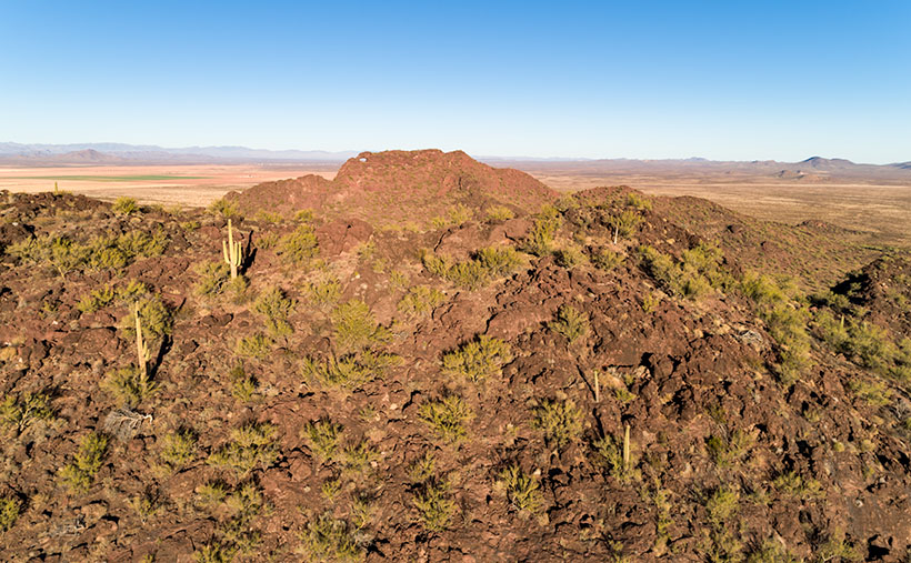
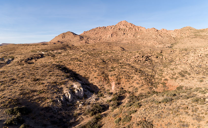
Eagle Eye East – The view from the top of Eagle Eye Mountain looking east towards the arch on Eagle Eye Peak in Aguila, Arizona.
Letting my romance wilt on the vine, let’s talk about this week’s featured image. As I promised last week, I wanted to show you the Eagle Eye Arch from another angle. In this image—that I call Eagle Eye East—we’re looking at the arch from the south side of the mountains in Aguila. I shot this picture from the top of Eagle Eye Mountain facing Eagle Eye Peak, and that’s why the arch seems more distant than last week’s photo. Since this was the sunny side of the mountains, it better shows how rough the lava surface is. I like how the bright green saguaro and palo verde contrast with the reddish-brown rocks.
Another interesting thing in this image—to me—is the background mountains. The Forepaugh Range is on the right and beyond them is the town of Wickenburg. Beyond the Aguila Valley, the tall mountains on the left horizon are the Weavers, and that’s where we call home.
You can see a larger version of Eagle Eye East on its Web Page by clicking here. Be sure to come back next week, and I’ll show you the final shot that I liked from my outing in Aguila.
The last time I wrote about Aquila’s Eagle Eye was in 2018, and I didn’t have much to say about it—other than it was there. That post included a photo I shot with a telephoto lens from miles away. I had to do that because much of the land around the peak is posted as private. There were two comments in that column. The first was from Fred, who thanked me for pointing the bridge to him, and the second was from my old friend Gary, who chastised me for not getting closer.
Since I’ve been hanging around Aguila this month anyway, I thought I’d try to make Gary happy. About three miles south of Aguila are mountains on the east flank of the Harquahala range. They almost have the same name; Eagle Eye Mountain is on the west, while Eagle Eye Peak is the lump of lava to the east (they touch one another). The latter peak is the one with the window on top.
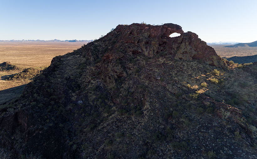
Eagle Eye Peak – A natural arch on top of a peak several miles south of Aguila, Arizona. Behind Eagle Eye is the Harquahala Plain, which stretches south to the Big Horn Range on the horizon.
You can get very close to the arch if you drive to the old cemetery where Eagle Eye Road bends around the mountains. The bad news is that you can’t see the arch from there because it faces east, and all you see are the rocks from the edge. There’s a better view if you scramble up an 800′ cactus-infested lava hill like an insane person, but I did the lazy thing. I brought my drone, and I flew it to the mountaintop. Once it got up there, I rotated it to the right and composed this shot.
The Eagle Eyes, like a lot of low desert mountains, were formed from volcanic activity. This particular pair of mountains is basalt-covered limestone. The rocks are much darker than the rest of the Harquahala Range. They appear as shadows on the horizon. Their surface is rough and pockmarked, like they had a bad case of acne. They are riddled with caves formed by air pockets in the lava.
I didn’t find an article that explains how this arch was formed. I don’t think it was formed from wind erosion. The rocks aren’t polished. It could be from one of those air voids in the thin-walled lava collapsing. My favorite guess is this: If this is Rhyolite—slow-moving lava common to peak formation—then maybe a cone of lava formed vertically, and as it cooled, it slumped over and froze in place. At least, that’s what it looks like to me. What do you think?
Well, Gary, I hope you’re happy. Click here to see a larger version of Eagle Eye Peak on its Web Page. Be sure to return next week when I’ll show you the arch from a different perspective.
It’s already the last day of January. Where does the time go? After looking at this month’s photos, it seems that I spent a lot of my time around Aguila—with good reason. That’s the route that Queen Anne and I take when we travel west, so I knew there was stuff to shoot, and it’s close by—well if you consider an hour close.
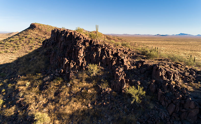
Foothill Uplift – A pair of hills thrust into the air by plate tectonics.
This week’s featured image comes from the same area. I didn’t have to travel far after I captured last week’s picture—Harcuvar Forest. In fact, all that I needed to do was turn around. OK, let me explain. I wanted to shoot the saguaro forest ever since I first saw it on a trip to Robson’s Mining World, but it’s miles north of the highway and tucked under the cliffs of the Harcuvar Mountains. My topo map shows a jeep road that runs behind a couple of hills situated between the highway and the forest. The hills screen the cactus patch from the highway. So, me and Archie did a little four-wheelin’.
After I had finished shooting the saguaros, I noticed that the north side of the hilltops behind me weren’t rounded as they appear on the south. Instead, they had a ridge of broken rocks—plate tectonics fractured them and pushed them towards the sky. Since I find edges like these interesting, I decided to waste some time photographing them.
This week’s featured image is the result of my curiosity. I call this photo Foothill Uplift. There are a couple of things that I like about this image. I like how the second hill repeats the pattern of the foreground one. It’s like they’re lined up for presentation. The same wedge shape shows up again on the photo’s right side. Along the horizon and on the far side of the Aguila Valley is our old friend Black Mesa. It’s the western high peak of the Vulture Mountain Range that stretches all of the ways back to Wickenburg. Finally, I love the double-headed saguaro, which I couldn’t see from the trail. It’s the garnish that completes the cocktail.
You can see a larger version of Foothill Uplift on its Web Page by clicking here. Be sure to come back next week, and I’ll see what I can scrounge up from around the neighborhood.
Our little town is not so different from yours. We have crime here too. That’s why the county sends a couple of deputies down from Prescott to patrol our streets and keep us safe. Most of the time, they drive around the empty streets, but there are moments where a rush of adrenalin flows through their veins—like last Friday night.
As most cops do, deputies Starsky and Hutch parked their cruisers on the dead-end street between the Dollar Store and the Quickie-Mart in such a way that they could drink coffee, chat across their door windows while keeping an eye on the only traffic control sign in southern Yavapai County. The night had been rainy but peaceful up till then.
Shortly after Congress’s only cowboy gay-bar closed, a pair of suspicious cars rolled up to the stop sign before turning south on Highway 89. Starsky noticed that a woman with long blond hair was driving the lead exotic Italian sports car (Around these parts, a Fiat 500 stretch limo is considered exotic) in the din of the sodium-vapor street lights. “I have to check this out,” Starsky yelled out his window, stowed the coffee in a cup-holder, put his cruiser in gear, and drove off in chase.
As he perused the little import through downtown Congress, he crossed over the double yellow lines, raced around the second vehicle before cutting in front of it. Then he lit up his lights and pulled the Fiat over. As he called in the plates for wants-and-warrants, he noticed that the sinister black Buick had pulled in behind. Sensing a threat, he radioed Hutch for back up. When he finally saw the second set of emergency lights in his mirror, he felt that he could safely get out of his cruiser.
Hutch had already climbed out of his truck behind him with a Maglite in his left hand while resting his right hand on his holster. He walked up to the second suspect’s vehicle and heard the last remaining Jennifer Rush Disco CD blaring through the stereo. The woman behind the wheel sat motionless with her hands in the air. “Mam, can you tell me why you pulled off the road behind my partner?” (OK, to protect the innocent, I have to change some names. Donna is the floozy driving the Fiat because Donnas always drive convertible sports cars. The gangsta-girl in the second car I’ll call Princess Margaret. Yeah, that works. No one will ever guess their real names.)
“That’s my friend, Donna,” Margaret replies. “I just want to make sure she gets home alright.”
“Well, this is a dangerous place to park. You’ll be safer if you pull in front of the other vehicles.”
With that, Margaret put her hands down, put on the left blinker to signal the empty highway that she was pulling out. Slowly she drove around the other cars, signaled that she was pulling back off the road, she put the car into park, and—once again—raised her hands over her head.
As Starsky strutted toward the hottie in the little white Italian Job, he practiced his best, “So, how you doin?” But when he got to her open window, the flashlight glare revealed far more lines of wisdom on her face than he expected, and her long tresses weren’t blond; they were pewter. His training and quick thinking let him instantly change tact. Instead, he asked, “Do you know why I pulled you over?”
“No, I don’t.”
“You didn’t come to a complete stop at the sign on 71.”
“Yes. I believe that I did.”
“That’s OK; I’m going to let you off with a warning,” which is what cops do when they can’t prove something in court. It also leaves a paper trail that shows they were working.
Donna—the consummate socialite—tried to get on the deputy’s good side, “I understand. My first husband was a Highway Patrol Officer.”
“When was that,” Starsky asked.
“During the late sixties and seventies,” she replied.
“That was long before I was born,” he gasped.
After Starsky filled out the form, he handed it to Donna and watched her drive off. Margaret finally put her hands down and followed into the darkness. As he walked back to his Tahoe, it finally sunk in that he almost hit on his grandma; he doubled over and blew donut chunks onto the front tire. From the other cruiser, he could hear Hutch’s giggling float across the damp night air.
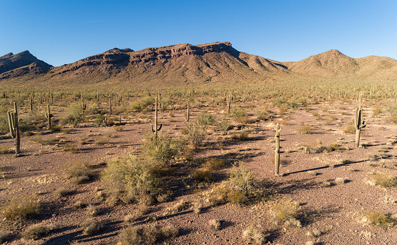
Harcuvar Forest – A large grove of Saguaro grows along the eastern flank of the Harcuvar Mountain Range.
You may be wondering what this story has to do with this week’s picture. Well, actually, nothing other than our town’s stop sign is on Highway 71, and at the other end of that road—near Aguila—is where Santa rests, and there is a large grove of saguaros growing along the eastern flank of the Harcuvar Mountains. That’s where I took this week’s picture, which I call Harcuvar Forest. When I drove home from that shooting, I stopped at that very intersection—without getting arrested. I guess that I’m not cute enough.
You can see a larger version of Harcuvar Forest on its Web Page by clicking here. Next week, I’ll bring you another image from around our house.
Our home in Congress is on a scenic byway. Each weekend, lines of exotic sports cars and motorcycles pass by our trailer park to prove it. Several roads, like AZ 89, in our state offer motorsports enthusiasts a venue to stretch the legs of their beloved machines. I’m sure that the other states have roads like ours. I’m surprised someone hasn’t compiled an encyclopedia of “The World’s Great Weekend Roadtrips.”
The route passing our home is known as the back road to Prescott because it avoids the weekend traffic on Interstate 17. It’s a longer drive, but that’s not the point. I think this passion is best described in Queen’s song; I’m in love with my car. “. . . get a grip on my boy-racer roll bar…” (Yes, Virginia, Queen recorded songs other than Bohemian Rhapsody). It’s customary to play this anthem at full volume with the top down and the sun flickering through the pines onto your Ray-Bans.
There are actually two ways to get to Prescott from here. The first is to stay on ’89 and drive between the Sierra Prieta and Bradshaw Mountains. The motor-heads like this way because they get to test those big Brembo brakes on their Lamborghinis. This way, it is challenging to keep up with the speed limit; you’re up in the pines quicker, and the road dumps you onto Whisky Row, where everyone parks around the courthouse for an impromptu car show.
The second option is better if you tow a trailer, haul a load of eggs from Costco, or try to keep Queen Anne from throwing up in your lap. To go this way, you turn off at Kirkland Junction and pick up Yavapai County Route 10—Iron Springs Road. This route is more docile as you travel through Kirkland, Skull Valley, and Iron Springs, although it’s a bit trickier to find your way downtown once you get to Prescott.
Kirkland Peak—Runoff from the granite-covered mountain has cut into a limestone layer deposited on an old lake or sea bed.
On this second route, you’ll see the subject of this week’s featured image—Kirkland Peak. The rocky mountain will fill your windshield at the Kirkland stop sign. There’s even a better view if you drive straight and cross the tracks. But right now, we’re going to turn right onto Iron Springs Road toward Prescott because there’s something else I want you to see.
Soon after leaving the junction, CR 10 follows the railroad tracks and Skull Valley Wash, filled with cottonwood trees. In this section, between Kirkland and Skull Valley, there is a cluster of limestone hoodoos where the granite top layer has been eroded. I’ve tried to photograph the outcrops on several occasions, but telephone lines and private property frustrated me. When I visited last week, a new mine began setting up operations, and they scraped the land clean. There are two new five-story silos built beside the road, and I’m afraid that the remaining hoodoos will be gone shortly.
When I drove up to shoot Kirkland Peak this week, I was pleased to find where the mountain’s runoff has exposed more limestone, as seen in this week’s picture, called Kirkland Peak. There are eons of geology exposed in this photo. The bottom layer is an ancient lake or sea bed, covered by granite (lava cooled slowly), and a mountain thrust above it. The evidence of up-thrust is in the grain of its rocks along the ridgeline (you can’t see that on your phone). As Kelly Bundy said, “The mind wobbles.”
Click here to see a larger version of Kirkland Peak on its website. Next week, I’ll bring you another image from our corner of the world.