Ancient Door Picture of the Week

Ancient Door - A mysterious door between Lomaki rooms beckons you to see what's on the other side.
Ancient Door – A mysterious door between Lomaki rooms beckons you to see what’s on the other side.

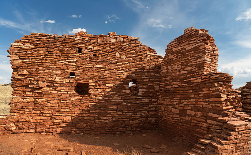
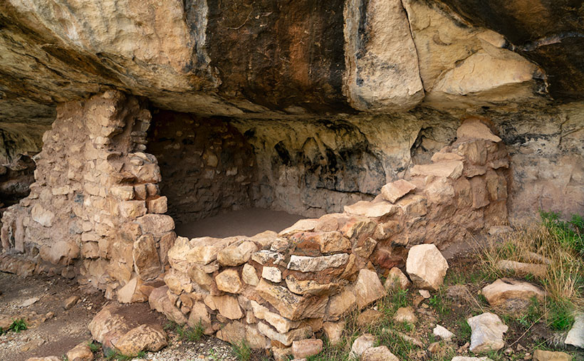
When I photograph a place like Lomaki (the Hopi word meaning Beautiful House), I try to walk its perimeter, looking at how the light falls on it. Then I look at details that help fill in its story. As I move around, I’ll stop and take shots of things that intrigue me. My photos are more intuitive than systematic. I look for contrasts and shadow patterns that place the subject in a specific moment.

I was doing that when I entered the Lomaki ruin and came across the door in this week’s picture. I saw the door and thought, “This looks interesting.” I framed the shot and snapped the shutter. Typically, an image with a busy pattern in a uniform light doesn’t work because it looks like a Where’s-Waldo puzzle. However, the dagger of light on the room floor commands your eye to go through the opening. It’s a walk-towards-the-light moment.

As a younger man, I was six-foot tall, but gravity has taken its toll, and now my diminished stature is only 5 foot 11½ inches. Even in my current dwarf state, I had to do a full Asian bow to fit through the doorway. That means that the Pueblo people that built this structure were short. Otherwise, they would constantly bang their heads on the lentil when they came home Saturday nights drunk from the bar. Believe me, that gets old fast.

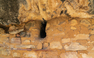
As I walked through the complex, I got to another room with a low window. Through it, I saw a creature with five legs. It gave me a fright. Was it a centaur with an extra appendage or a giant arachnid with three legs missing? On closer inspection, I saw three legs were carbon fiber, and the other pair wore shorts. The creature turned out to be a fellow photographer. She was a coed from ASU working on a YouTube video about Wupatki.

It’s funny how photographers behave when they bump into one another out in the field. After seeing another camera, they let down any guards. They stop being solitary wanderers and suddenly become highly social as they compare notes. “Did you see this?” You should go there.” In the age of digital photography, it’s gotten worse because now they can compare their shots on the back of their cameras and go into full chimpanzee mode, “Look at this one—ooh ooh ooh ah.”

After our pleasantry exchanges, we parted ways, and she returned to the parking lot. Of course, I didn’t ask for her name or YouTube channel. Queen Anne would kill me on the spot if she knew I talked to a college-aged woman in the field without her chaperoning. After I finished shooting, I hiked back to the parking lot, where Her Majesty was waiting in the car. If I was lucky, her nose was buried in her Kindle reader, and she didn’t notice anything. Before I could say a thing, she blurted out, “I asked that girl if I had to go rescue you.”

“What did she say?”

“She said you were happily wandering around snapping pictures, and you’d be there until you ran out of film.”

It was only then that I realized I was a bit hot, so I started the Jeep and guzzled some water in the cool air conditioning before driving back to Flagstaff. So far, there are no new YouTube Wupatki videos, but I’ll keep looking while I dream of mermaids.

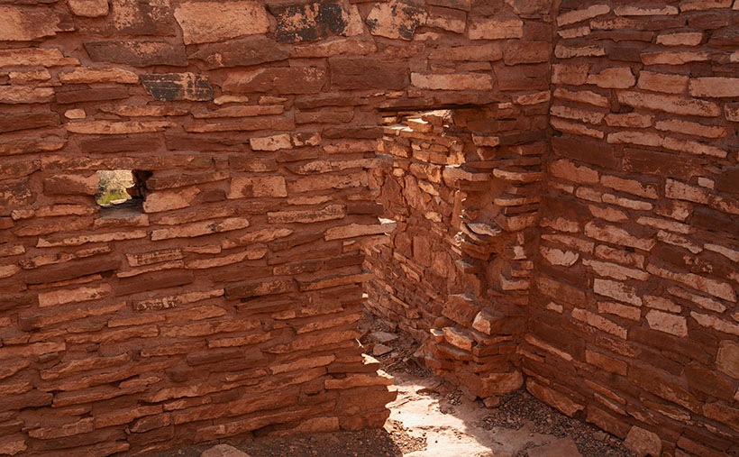
You can see a larger version of Ancient Door on its Webpage by clicking here. Next week, I’ll show my last shot from Lomaki, so be sure to come back and see what we find.

Till next time
Jw

BTW:

It’s Thanksgiving week, so Queen Anne and I wish you a happy and safe turkey day.

Lomaki Picuter of the Week

Lomaki - The crooked walls look as if the fierce Northern Arizona winds will blow them over.
Lomaki – The crooked walls look like the fierce Northern Arizona winds will blow them over.

In the half-century that I’ve called Arizona home, I can’t count the times that I’ve traveled thru Flagstaff and then north on Highway U.S. 89. I travel that route to get to the Grand Canyon, Lee’s Ferry, Lake Powell, Monument Valley, Utah, or Colorado. My best guess would be once a year on average. Sometimes I even stop to take pictures along the way.

With that many trips, you’d think I’d pay no mind to the scenery, but that’s not true. There’s always something new. There’s one location that makes my jaw drop, no matter how many times I see it. I’m talking about the view at Sunset Crater Pass I wrote about last month. It’s an in-your-face example of something I learned in a college geography course: mountains affect climate.

The climate on the south side of the San Francisco Peaks is the polar opposite of that on the north. As you travel to Flagstaff from Phoenix, you climb into the pines, and the temperature can drop as much as 30° along the way. As fronts move north from the Gulf in the summer or west from the coast in winter, the mountains wring moisture from the air as it climbs the slopes. After passing over the mountains, the air is dry and picks up pressure on the way down. Dry air heats faster than humid air. The phenomenon creates a rain shadow on the mountain’s leeward side. The next time you travel north of Flagstaff, stop your car at the pass and take a look back—trees. Then turn to the north again—trees kept away.

Now that you know how mountains work, it’s easy to understand why the early Pueblo Tribes living at Wupatki lived in rock dwellings instead of log cabins. Amazingly, the Indians still used timbers to span the walls and hold up a roof. That means they had to drag lumber off the mountains by hand. They built their structures before the Spanish arrived, so they didn’t have horses.

This week we’re looking at one of the bigger pueblos in the National Monument—Lomaki. That’s a Hopi word that translates into English as “Beautiful House.” Anthropologists have partially restored its two-story walls. As you walk through the ruins, you begin to appreciate the ancient people’s masonry skills and tenacity. They must have had to rent scaffolding for walls that size at A-Z Rentals in town. It was either that or standing on one another’s shoulders. You’d do the same thing.

In this week’s picture, titled Lomaki, you get a good idea of the wall height. The windows are at eye level. A peculiar thing you notice in this shot is the walls are leaning. I’m not sure if the scientist put that feature in on purpose or if they weren’t as skilled as the original Pueblo builders. As a photographer, I have a thing about lines that aren’t level or square. Oceans don’t run downhill, so I wince whenever I see a seascape with a crooked horizon. On my first visit to Lomaki decades ago, its tilted walls jumped out at me. They look like a good wind will blow them over—and this area of Arizona is exceptionally windy. However, on this year’s visit, the walls were still standing and didn’t seem any worse, so maybe they’ll remain long after I’ve gone.

You can see a larger version of Lomaki on its Webpage by clicking here. Next week, we’ll walk around Lomaki and see its details. Come back then and see what we find.

Till next time
Jw

BTW:

The calendar cut-off day is Tuesday, so if you are interested, place your order.

Motel Downtowner Picture of the Week

Motel Downtowner - The 1930's sign was built on a tower to lure tourists off of Route 66.
Motel Downtowner – Nackard built the 1930’s sign on a tower to lure tourists off Route 66.

Tourism is Flagstaff’s biggest money maker. According to one ASU study, tourism accounts for 84% of the town’s employment. Some of our non-Zonie friends may wonder what the attraction is; most out-of-state people don’t know much about our state and can only name two Arizona cities. Every season has a reason to visit the town at the bottom of the mountains. As I said at the beginning of this project, its 6,909-foot elevation (1,600 feet higher than Denver), mild weather is an excuse for valley lowlifes to visit and escape the heat. Fall ushers in colorful aspen trees that the annual fires haven’t burnt—both of them. Then, in winter, some people like to strap planks to their feet and slide down the big hill out of town. Finally, everybody goes to Flagstaff to toast marshmallows during the spring fires.

In the above list, I didn’t mention the daily traffic on Beal’s Road—Route 66—now Interstate 40. It’s an excellent place to stop for a meal or to get some sleep. And—oh yeah, I forgot—it’s how you get to the Grand Canyon.

It’s no wonder overnight lodging shaped and dominated Flagstaff architecture—from abandoned stone ruins to tacky Route 66 motels to today’s boring corporate three-story shoeboxes lining I-40. I think it’s understandable but sad that, as highways evolve, the old buildings and signs are disappearing. I get a big grin when I see one standing and add it to my collection. It must be the same thrill a hunter gets when shooting a Moose, Elk, or Kiwanis.

Apartment House - I shot this down the street from the Downtowner sign. I'm positive that if my wife ever set foot in this building, it would rip a hole in the space-time continuum.
Apartment House – I shot this down the street from the Downtowner sign. I’m positive that if my wife ever set foot in this building, it would rip a hole in the space-time continuum.

Last week, I wrote about Du Beau’s novelty concept—lodging catering to the motor car traveler. His motel was the second of its kind in the country—the first was in San Louis Obispo, California (that one burnt down, which makes Du Beau’s the oldest survivor). The buildings in this week’s image are ten years older but were initially used for other purposes. According to one account, it was a brothel. How scandalous. There were whore houses in the west—who knew? It wasn’t until the 1930s that K. J. Nackard bought the place and turned it into a motel. At the time of its opening, the main road through town was on the south side of the tracks. Later, the highway department realigned Route 66 to the north side. That’s when the sign wars began.

If you’re fishing for customers and they drive by your door, you can hook customers on a bamboo pole, but when the traffic is on the far side of the train station, it’s time to break out the surfcasting tackle. Both motels began building bigger and brighter signs to lure travelers to the Bohemian side of Flagstaff. These signs make today’s city planners shudder.

I took this week’s photo, which I call Motel Downtowner, with the rising sun. I had been walking around town in the twilight, and the tower was one of the last places I shot. It was after 7:00 by then, and I needed a cup of coffee (Macy’s European Coffeehouse—he’s also a fellow photographer). I have tried to get a shot of this tower for years, but I’ve never been happy with my results.

Ford GT40 - Evidently, not all residents at the Motel Downtowner are lowlifes. I found this car parked in the motel's portico, and is rare, even for Route 66.
Ford GT40 – Evidently, not all residents at the Motel Downtowner are lowlifes. I found this car parked at the motel’s entrance ten years ago, and it is rare, even for Route 66.

You’ll notice that the characters are angled to be readable while driving the Mother Road, and that angle points to Route 66. The motel is no longer open. Another type of business has taken over the buildings, but the sign remains; somebody in Flagstaff appreciates good kitsch and history as much as I do.

You can view my Motel Downtowner web version on its page by clicking here. Next week, we have another historic Flagstaff hotel sign to show, so be sure to join us then.

Till next time
Jw

BTW:

Oh, you’re still here even though the show is over. You must read to the end of the article. Good on you, mate. You’re probably wondering what’s down here in the basement. This is my new ongoing section with announcements, follow-ups, answers, etc. I intend it to be a paragraph long (my fingers are numb) so I don’t have to clutter your inbox with extra mailings. I hope you find it helpful.

Motel Du Beau Picture of the Week

Motel Du Beau - This 1929 establishment was one of the first to cater to tourists driving those new-fangled motor carriages.
Motel Du Beau – This 1929 establishment was one of the first to cater to tourists driving those new-fangled motor carriages.

When Queen Anne and I spent a week in Flagstaff last month, our primary goal was heat relief, but I was confident that I could snap a few shots of historic buildings and signs to add to my Route 66 collection. In this journal, I’ve written several times about my experiences traveling the Mother Road as a kid, so I’ll spare you from repeating them. Instead, I must say that I was disappointed at how hard it was to find kitschy motel and dinner signs along the main street. More profitable strip malls and professional offices are rapidly replacing them. Interstate 40 travelers prefer the newer hotels on Butler Street, where the Little America Hotel is. Nobody drives 66 anymore—too many lights and too much traffic.

John Steinbeck’s novel The Grapes of Wrath, the depressing story of dust bowl migrants, searching for survival, didn’t make Route 66 famous. Nor did that fame come from my father’s generation, who—like the Joad family—moved en masse to California after World War II. It came when Angel Delgadillo—the Seligman barber—pitched a historic highway idea to the State of Arizona. When that designation came through, tons of beer-guts had a play-pen to gather and drive their car toys. We’re dying off now, and like the coals in your Webber Grill, that passion is dying with us.

Master photographers Ansel Adam and Minor White influenced how I photograph the world. Still, in 1975, the George Eastman House showed a photo exhibition called The New Topographics: Photographs of a Man-Altered Landscape. The show still floats between museums today. It was a collection of ten photographs made by ten photographers that were opposite the landscapes I embraced. It was heresy. The photos are stark images of industrial buildings and houses devoid of people. I didn’t even think some of the artists printed very well. But I did kind of like the ones John Schott did. His pictures were of Route 66 motels. You can see where this led.

Flagstaff Train Depot - Either this is new or I've been blind, but the coolest Route 66 sign that I saw was the train station's address.
Flagstaff Train Depot – Either this is new, or I’ve been blind, but the coolest Route 66 sign I saw was the train station’s address.

I’ve considered compiling a book of my Route 66 photos. I have several, but most are from Arizona, with a couple from California and New Mexico, but nothing east of Texas. If this horse hadn’t been flogged to death, I still could work on my own Mother Road project. Now that I’m retired, I have time. I figure a month on the road should do it. To do it properly, I’d have to drive a classic car—something from the ’50s or ’60s. However, it needs air-conditioning, cruise control, and a good stereo (I won’t put up with AM radio stations dropping out under bridges). My ultimate ride would be a red ’62 Corvette—like the one Buzz and Todd drove—but hold the whitewalls. I could haul my camera equipment behind it in a small aluminum trailer like the autocross guys lug their race tires. October is a perfect month for a road trip, so if anyone out there wants to be my Angel investor, let me know. You’d get all the bills, half of the proceed, and a free book out of the deal.

This week’s featured image is of a prominent Flagstaff landmark. It’s called Motel du Beau, and the subject is the sign. It’s one of three hotel signs towering above the city (can you guess what this month’s project is). With the Lowell Observatory on top of the hill, Flagstaff has adopted a dark-sky policy, so the zoning people would never allow these enormous signs in town. If they weren’t historical landmarks, the city would tear them down.

In the late 1920s, Albert Eugene Du Beau vacationed in northern Arizona and envisioned a new way to make money. Instead of building a multi-story building for railroad and train travelers to stay, why not create a place for people traveling in these new-fangled motor cars? So, he designed and built a single-story motor-hotel (later shortened to motel) to be convenient to unload and load their vehicles in 1929. His design featured a U-shaped layout with steam-heated garages (they burned down in a 1970s fire) and indoor toilets. He built his motor court adjacent to downtown’s main street, which was brilliant because, in time, the busy highway became Route 66. The Motel Du Beau was one of the pioneering businesses to use neon signs and elevate them on towers.

In today’s modern world, the Motel Du Beau still looks like a nice place to stay, with rooms starting at $75—a far cry from the original price of $2.50 per night. Their website shows various room types, and they have a lovely little wine lounge called Nomads. I’d certainly be willing to try it after they reopen the bar.

I hope you enjoy seeing a part of Flagstaff’s history. You can view my Motel Du Beau web version on its page by clicking here. Next week, we’ll look at another historic Flagstaff motel sign, so be sure to join us then.

Till next time
jw

Corner Unit Picture of the Week

Corner Unit - I found this unit at the end of a row of homes. It shows all four walls inside and out, so you get and idea of how large these home were.
Corner Unit – I found this unit at the end of a row of homes. It shows all four walls inside and out, so you get an idea of how large these homes were.

“283 steps” were the first words out of the park ranger’s mouth when I asked about the Island Trail. “It’s 283 steps down to the loop, and there are 67 steps around the island,” (that number could be wrong—I stopped listening after 283), “and then back up those sane 283 steps.” I thought, “It’s the cool of the morning, it’s cloudy, I’ve got water, I need pictures from the trail, so let’s do this.” Then I walked over to the top of the staircase.

Although the Island Trail is less than a mile, it’s the harder of the two in Walnut Canyon National Monument. You’d be correct to believe it went down to the creek with that name. Instead, it drops 185′ to a land bridge where you cross to an unnamed promontory that you circle counterclockwise. The trail is asphalt paved except for the sandstone steps.

The path is on a shelf where the limestone sits above white sandstone, like found in Zion National Park. The limestone erodes faster than its foundation, and like an ice-cream scooper, that erosion has gouged shallow caves into the white stone. Here is where the Sinagua built their homes. While descending the stairs, I could see dwellings on the opposite side of the creek. They’re spaced apart, so I thought that I get to shoot one or two of the rock dwellings. I was wrong. The canyon’s far side faces north—not the ideal winter location. On the island, the homes were south-facing, which helps keep them warm. As soon as I rounded the first bend, rows of rock dwellings were there for me to explore and photograph. But, I had to sit down first and rest a while—I was still shaking from coming down the stairs.

Before I got to the pictures, I had another interesting observation. I thought that since I had made it a third of the way down the canyon’s bottom, I would be able to catch a glimpse of the creek. With the heavy monsoon we’ve enjoyed this summer (yey), the foliage growing on the canyon floor was so thick it completely obscured the creek bed.

I took this week’s picture—that I call Corner Unit—at the end of several homes. Since they run into one another, they usually share a common wall—like our modern apartments. So, this one has two exterior walls, which is unusual for this neighborhood. Since the Park Service didn’t fully restore the walls, you can see the cave’s overhang and back wall. With it being open to the outside, you can get an idea of its area. The Sinagua people must have felt comfortable with this size because it’s representative of them all. If you think about it, this is a perfect size for a man cave. There’s room for a corner TV, and you can grab a brewski without getting out of the Barkalounger. Once again, however, you’d be stuck at home all day waiting for Larry to show up.

The problem with the man-cave theory is that the women built them and were primarily concerned with keeping in the warmth. In the second image, you can see where they left a vent near the ceiling. These vents allowed them to have small fires inside and let the smoke out. They were their chimneys. The families could survive the high-altitude winters by draping an animal skin or rug over the door and building a small fire.

Fire Vent and Clay Finish - The Sinagua People built vents into the walls so they could enjoy a fire and not suffocate. They also stuffed clay into the rocks to seal the rooms from drafts.
Fire Vent and Clay Finish – The Sinagua People built vents into the walls so they could enjoy a fire and not suffocate. They also stuffed clay into the rocks to seal the rooms from drafts.

The second picture also shows another innovation the women used to make winter life bearable. They hiked to a place up the creek where they could dig gold-colored clay (the color’s not essential—this isn’t The Real Housewives of Beverly Hills), then they packed it in baskets, lugged it back, and smeared it over the rock walls—inside and outside. Like caulk, the clay sealed the wall gaps and stopped drafts. The women put a lot of thought and work into their homes—the men were too lazy to take down the Christmas decorations.

After I finished my tour of the loop and got the needed photos, I was back at the foot of the stairs leading to the visitor’s center. I found out that the ranger lied. Somehow while I was out of sight exploring ruins and taking pictures, the park service snuck in and doubled the stair count. How do I know; math, simple math. I knew I would have a tough time with the climb, so I devised a system where I would climb 50 stairs at a time—then stop for water and catch my breath. Instead of five rest stops, I made 10, and I drank both of my water bottles dry. Near the top, where I could finally see the building, I made one last effort; one, two, three, four, twelve, fifteen, thirty-five, fifty. I need another rest.

I hope you enjoy seeing the ruins in Walnut Canyon. You can view the Web version of Corner Unit on its page by clicking here. Next week, I’ll have another shot from the Island Trail for you to see, but please don’t make me go down there again.

Till next time
jw