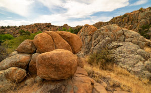
Orange Boulders – Lichen-covered granite boulders have weathered and fell off their tight-fitting stack.
A this week’s featured image shows, the trails of Granite Dells City Park provide diversity you wouldn’t expect to find in a massive formation of slow-cooled lava. This week’s featured image shows a small example of that. It comes from one of the Flume Trail’s spurs. Instead of walking around a ridge, this option climbed over it, before it descends and rejoins the main path on the other side. I’d call it a shortcut, but since it added a climb, it didn’t save any time.
On the ridge, the view opens, and since the granite pile tops were exposed to weathering longer than below, so more of the car-sized boulders lay scattered on the ground. If you’ve only driven by The Dells, you’d get the idea that the rocks are nothing but dirt. As you can see in this image, they’re actually covered with lichen of various colors. Here an orange species grows next to a green varietal. Up close, they give the rocks a velvety texture.
I stopped along the trail to capture this image because this tumbled pile of rocks stood apart from assembled puzzle stacks surrounding them. The distinct orange color caught my attention too. There are other colors that you’ll see as you walk along the trails. We’ll bee seeing some of those in other photos this month. Finally, I included a bit of the trail in this image to add a leading line and some perspective to the image.
You can see a larger version of Orange Boulders on its Web Page by clicking here. I hope you enjoy viewing my newest entry and come back next week when we show another photo from Granite Dells.
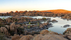
Granite Dells Sunset – Prescott’s city park has two creeks, two lakes, and a bunch of rocks to climb. It’s a playground for adults and a wilderness experience inside city limits.
Welcome to July—the start of the year’s second half and when our nation comes together to celebrate Queen Anne’s birthday. Time flies when you’re having fun … and evidently, even when you’re not. As we tear another month from this year’s calendar, it’s also time to introduce the place we’ll visit: Prescott’s Granite Dells City Park. We were here five years ago during the tragic Yarnell fire, but this time, we came better prepared with experience and a real camera.
Granite Dells—or The Dells—is a “McDonalds’ playground” for adults. The park’s trails take you through or around the rock maze. There are secret rooms to discover, rocks to climb, narrow passageways to squeeze through, and creeks to ford. The only thing missing is the restaurant’s ball pit, where kids pee. The trail lengths vary so that you can spend an hour or an afternoon wandering among the giant boulders all day.
A million and a half years ago, a magma pluton—a six square-mile glob of molten lava shaped like a giant balloon—tried to force its way to the surface as the eruptions in Hawaii have done. Instead, because it didn’t have enough energy to bust through the rocks above, it was trapped and cooled slowly and crystallized into granite. Another famous example of a pluton is Yosemite’s Half Dome. As millennia passed and the forces of erosion and plate tectonics shaped the earth, the pluton eventually made its way to the surface. It has been exposed there long enough for the formation to fracture and undergo spheroidal weathering—the erosion that rounds the rock’s edges. Yavapai County has two other places where you can see these kinds of rock formations: the town of Yarnell along SR 89 and the hilltop where the truck stop of Nothing once was on Route US 93.
The two creeks that drain through the Dells, Granite and Willow, were dammed in the early 1900s as irrigation reservoirs by Chino Valley farm co-operatives. In 1998, Prescott acquired a chunk of Granite Dells, including the lakes, and has set aside the area as an open-space park. The usual picnic areas and sports fields are there, but the backcountry trails lead into parts of the park where you get a taste of wilderness experience. That illusion is occasionally broken when the trail passes a No Trespassing sign along the periphery.
When we visited the park in June, we saw new home developments on its northern flank and another proposed on the east side along the Peavine Trail near Point of Rocks. The development was met with community outcry and packed meetings at city hall. Concerned citizens worry that the new developments will irreparably change Dell’s character by blocking wildlife movements and introducing a sea of roofs to the landscape. It’s another example of a good thing being loved to death. I guess it’s true what they say, “You can’t have your Kate and Edith, too.”
I took this week’s image after a Prescott meeting—not at city hall—that I attended. The sun was about to set, so I rushed to the Dells to get this shot. When I got to the Watson Lake overlook, I knew I wanted to capture this sweeping scene with the most detail. The format is a little different for me because this is a four-shot panorama. I took four shots and stitched them together in PhotoShop. The resulting file size is four times larger than my usual shots, and I can make a print thirty-six inches wide at full resolution. I made a crop of the shoreline tree in actual size to show how much detail I got using this method. This image is called Granite Dells Sunset.
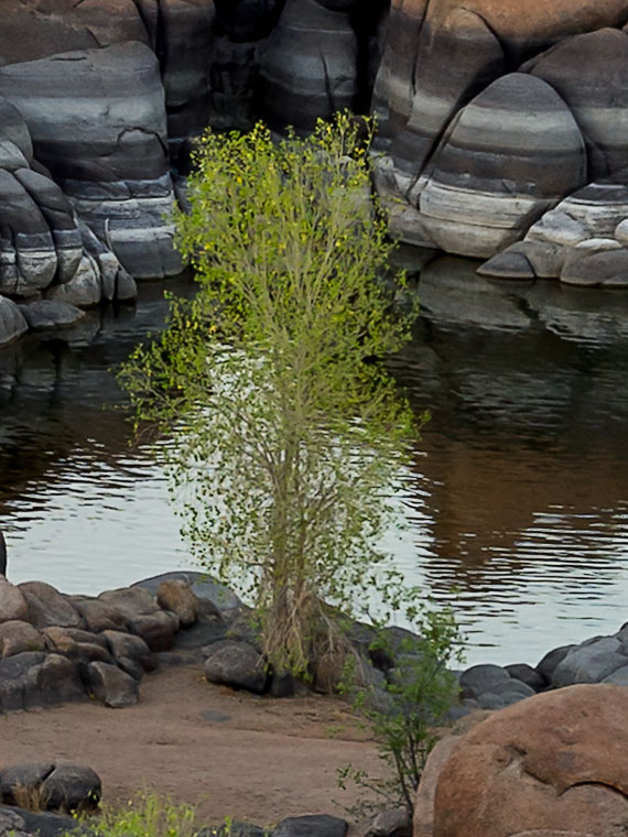
A full-size crop of the shoreline tree in this week’s image shows how much detail is in this image.
Click here to see a larger version of Granite Dell’s Sunset on its Web Page. It’s easier to find the tree in the larger version. I hope you enjoy viewing my newest entry and return next week when I post shots I took while hiking the park’s trails.
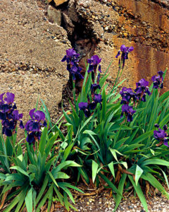
Jerome Iris – One of my better selling images. It was taken in 2004 on a Jerome trip I made with my friend, Russ Good.
I took this photo of iris in front of a cracked foundation wall in 2004 when my friend, Russ Good and I went to Jerome on a photo-shoot. It’s a popular image and has sold well. The photo’s story is the contrast—the softness of iris petals against the hardness of the concrete foundation and the vibrant purple flowers in front of dull concrete. It also speaks about longevity. The family that planted the flowers and the house they decorated are gone but the bulbs put out new flowers each spring without a caretaker. Getting this shot was difficult. I remember lying on my stomach in the street to focus the image on my 4×5’s ground glass while Russ stood guard over me. Each time I visit Jerome, I look for similar setups and I found another one that is this week’s image.
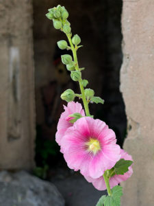
Art and Flowers – Not just a pretty flower picture. Someone watches that you don’t pick them.
I titled it Art and Flowers and I shot it from the sidewalk in front of the Hilltop Deli building on SR-89. Because my newer camera has a folding view-screen, I didn’t have to get down on the ground this time. Getting down is one thing but—at my age—getting up is another set of variables entirely. The hollyhocks seem to be popular in Jerome this year, they were in gardens everywhere. I selected this specimen because of the jagged wall behind it and the dark crawl space it frames. As you study the image, does it seem like someone is watching you? Well … you’re right. As I was shooting this, I tried different angles and in the middle of shifting positions, I noticed a painting on the wall inside the crawl space. It’s a portrait of a young lady—her chin resting in her hands—painted inside the opening in such a way that you don’t see it as you walk along the sidewalk. I don’t know who the artist was or how long it’s been there, but it’s not just graffiti. After I saw it, I knew I had to frame my last shot so that the hollyhock was in front—but not obscuring the painting—and I set my exposure to make the eyes barely visible in the background. It’s like one of the apparitions that Jerome is famous for. If you visit the version on my home-page—while this image is on display there this month—more of her shape revels as the image lightens.
You can see a larger version of Art and Flowers on its Web Page by clicking here. I hope you enjoy viewing my newest entry and come back next week when I post another Jerome photograph.
Until next time — jw
Ps: Thanks to Glenda Meyers and Sharon Roberts for flower identification.
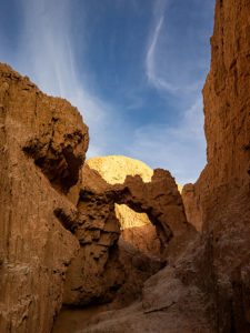
Continuing last week’s adventure to the mud cliffs at Alamo Lake, I took this week’s picture at the other end of the slot canyon. It’s not a very long hike—maybe fifteen minutes if you don’t dawdle—but I was exploring with a camera and stopped to take pictures often along the route. The reward waiting for you at the canyon’s head is this mudstone arch carved by rushing water draining from the surrounding mesa. If you hike a few yards beyond the arc, the canyon ends, and you’re on the mud flats between Date Creek and the Santa Maria River. The water is runoff from the Black Mountains in the north that has carved the canyon from the flats.
Mud Arch—As a reward for your effort, a mud arch is located at the end of a short hike up the slot canyon.
Since I’m not a geologist, I can’t tell you how old the arch is, but because the surrounding soil quickly erodes and because I slept in a Holiday Inn Express once, I assume that it hasn’t been there for very long—geologically speaking—and it may soon crumble. You’ll notice that the arch’s shape isn’t smooth and rounded like the sandstone arches in Utah, which tells me it hasn’t been polished by blowing wind. That’s another clue to its relatively young age. I won’t be surprised if it disappears in less than a decade.
When I arrived at this scene, the sun was low enough that it didn’t shine onto the canyon walls, but it did add that late afternoon glow to the mound behind it and separated the arch from the background—sort of a spotlight, as it were. With streaky clouds in the sky … what more could a photographer ask for?
You can see a larger version of Mud Arch on its Web page by clicking here. I hope you enjoy viewing my newest entry and tagging along for the other canyon shots I’m revealing this month.
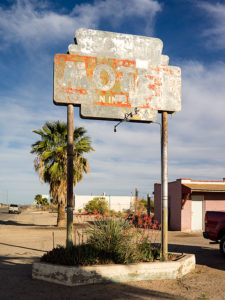
Motel Aguila – A faded sign marks the location of a motel on US 60 in Aguila Arizona.
This week’s new picture I call Motel Aguila, and it’s another faded motel sign for my collection. Located as you would expect, in Aguila—a farming town some twenty miles west of Wickenburg. It’s also across the street from last week’s shot, which is how I spotted it. The paint on this sign is so faded that I don’t see a business name, and there’s only a whisper of letters left to show it as a motel.
As the sign suggests, there is no longer a functioning motel here. The buildings seem to be converted to apartments sheltering migrant farm workers. With less than a thousand permanent residents, there aren’t enough people to work the melon and lettuce fields surrounding the hamlet. The workers have to sleep somewhere and I suppose an old motel is better than the improvised lean-to sheds I’ve seen elsewhere.
Aguila isn’t a destination. There’s a café, gas station, a Dollar General store, and that’s about all. In 1973, Interstate 10 diverted traffic twenty-five miles south, so there isn’t a motel to stay at even if you wanted to. Besides, the only thing to see here is the eagle-eye window in the hills south of town and that’s a fifteen-minute investment along the side of the road (I’ll talk more about the eagle-eye next week).
You can see the larger version on here on my website. I hope you enjoy viewing it and tell me what you think.