Road Bend Picture of the Week

Although I’ve tried my best to hold back time, the season has changed,  and it’s summer again in the desert. Summer’s dog days are the worst time to be photographing our arid home. Except for the brief respite at either end of the day, the bright sun and ozone combine to wash the colors away. It’s like seeing the world through a 2% milk bottle—the glass ones, not the cartons. You need polarizing sunglasses to force the blue to show in the sky again.

We desert-rats are nothing if not adaptive. Like all of the other Sonoran critters, we hide in our holes during the day. For example, the Round-tailed Ground Squirrel escapes the day heat in his den by sleeping splayed-out on his back. I do the same thing, and I’d show you photographic evidence except I’d be banned forever from the Internet. The other thing we do is migrate. Even during this pandemic, Highway U.S. 93 was a parade of boats heading north towards the rivers and lakes on this holiday weekend.

When we were deciding on a project for July, Queen Anne and I followed a similar logic. We looked for someplace cooler—trust me, 90º is cooler than 110º. We scoured our maps for a place nearby in the mountains, a location that wouldn’t have crowds yet be accessible. We settled on the Senator Highway that runs from Prescott south into the Bradshaw Mountains.
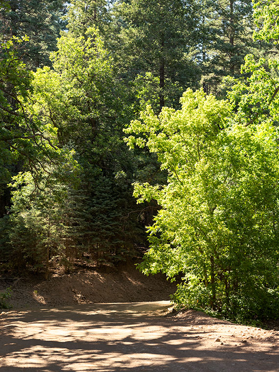
Road Bend - Bright yellow-leaved deciduous trees obscure what's beyond the road on the Senator Highway south of Prescott, Arizona.
Road Bend – Bright yellow-leaved deciduous trees obscure what’s beyond the road on the Senator Highway south of Prescott, Arizona.

Until this month, I didn’t know why there was a dirt road called the Senator Highway. I imagined that it was a route that our state assemblymen traveled when Arizona’s capital swapped several times between Prescott and Phoenix—foolish me. Instead, it’s just another mine road that the miners built it to transport ore and supplies between the Senator Mine and Prescott. If you’re skilled at navigating the Bradshaws, you can technically get to Congress via the Senator Highway.

I find the pine-covered mountains, like the Bradshaw’s, hard to shoot. The trees get in the way. I mean, how many different ways can you get an image of ponderosa pine tree bark? I hunt for edges—splashes of color, an opening to the horizon, or building ruins. That’s what I’m showing in this week’s featured image. At a bend on the highway, I saw some trees (I believe Arizona Ash) with bright yellow-green leaves shinning in the sun against the duller blue-green evergreens. I liked how they obscured the path. My mind wants to find out what’s beyond. It’s a classic leading-line perspective trick, and I find the dappled shade on the road a bonus. I named the first image for our July project Road Bend because it’s a simple title for a simple photo.

You can see a larger version of Road Bend on its Web Page by clicking here. I hope you like it. Be sure to come back next week when we present another image from the Senator Highway outside of Prescott.

Until next time — jw

Seal Mountain Picture of the Week

I wouldn’t have made a good prospector if I had lived during the Weaver Mountain mining boom. Since it is Father’s Day, a quote from my dad seems especially appropriate today. “You’re nothing but a lazy bastard, and you will never amount to anything.” Thanks, dad. I’ll cherish those words forever. He’s right, though. I don’t even like to water our flowers much less pick at a mountainside. In last week’s post, I was shocked to see in the photograph of my hand, a callous below my ring. Where did that come from—I haven’t touched a hand tool in decades.

If mining is off my list, what else did men do to earn wages back then? To find out, I continued my exploration of the Weaver Range east side by following the other side-roads near Placerita. This week I drove the Wagoner Road down to the Hassayampa River. I’ve never seen that area, and besides, I might get different scenes for my drone film. I struck pay dirt (sorry for the mining metaphor).

The Wagoner Road descends the east slope of the Weavers into a river valley where the Hassayampa flows above ground. As expected, where there’s surface water, there’s farming—or in this case ranching—big ranches. They’re stacked along the river one after another. They have well-maintained fences, impressive gates, and lots of black cattle (although I did see a herd that had Wagyu markings). The valley reminded me of north Scottsdale when it was mostly Arabian horse farms. It would be an ideal place to live except for grocery shopping. There are only two ways out, the 38-mile road back to Kirkland Junction or crossing over the Bradshaw Mountains on the Senator Highway (Wickenburg is only 20 miles distant in a private aircraft, which is possible given the size of these estates).

Seal Mountain - A remote mountain only seen in an obscure valley is the model that was used on the Arizona emblem.
Seal Mountain – A remote mountain only seen in an obscure valley is the model that was used on the Arizona emblem.

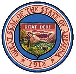
Since I was scouting new views of the Weaver peaks, I found a doozy. It’s the mountain that is in the background of this week’s featured image that I call Seal Mountain. Every Arizonian should know this mountain by heart because it was the model used for the Arizona State Seal. In 1912, who knew it existed? The only place you can see this peak is from the ranches in this remote valley. I’m impressed, however, that my local mountain range is represented on the Arizona seal.

The Arizona Seal - If you squint hard, you can see the similarity.
The Arizona Seal – If you squint hard, you can see the similarity. Personally, I would have chosen Four Peaks.

So, could I have been a rancher instead of working in a mine? MMM—maybe not. That kind of work still involves toiling with shovels, rakes, other hand tools, and even possibly riding a horse. Horses don’t like me. The last one that I road said, “Oof,” when I got on. Let’s take a closer look at that state seal—shouldn’t there be a programmer or a Web designer on it? Come to think of it, there isn’t even a real estate agent, and that’s the number one Arizona job.

You can see a larger version of Seal Mountain on its Web Page by clicking here. I hope you enjoy it. Come back next week to see what else we found along the road to Placerita.

Until next time — jw

Thimble Mountain Picture of the Week

Don’t tell anyone, but we snuck out of the house again. We had to. It’s the only way I could bring you fresh pictures for May. I think we did okay, though, because—as we always do—we never intended to interact with people. Since I never shoot anything with a face, I don’t run into many humans on the road.

For May, I wanted a road nearby so that we could get out and be home in the afternoon. I chose the section of Old Route 66 that starts in Kingman, travels through Oatman, and winds up at the Colorado River near Topock Marsh. I’ve written about my experiences traveling The Mother Road before but never completed this section. That’s because when my parents got to Kingman, they made a complicated right detour to Las Vegas. Queen Anne and I have visited Oatman several times, so we didn’t need to stop and feed the resident burros. I was more interested in shooting the Black Mountains in Sitgreaves Pass.

There’s a Black Mountain in every Arizona county (sometimes more than one), but the Black Mountain Range that borders the Colorado River from Lake Mead to Topock is the most interesting. It’s 75 miles of jagged volcanic peaks and rhyolite formations along the west border of Mohave County. They’re so rugged that only a handful of roads cross through them—even Interstate 40 loops 60 miles south to avoid the range. Our trip skips that loop as we got off the freeway near the Mohave County Prison, headed west across Sacramento Valley, and through Sitgreaves Pass.

As you drive across the wide valley, creosote dominates the landscape. There are yucca and an occasional cactus along the roadside, but none of the big succulents we have at home. Everything is sparser, which is a typical Mohave Desert. This desert is dryer than our Sonoran home because it rains mostly during winter. The southerly winds that bring the summer monsoons bypass the Mohave.

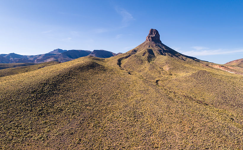
As the old road approaches the mountains, it travels up a canyon with high peaks on either flank. On the north side is a tall monument that marks the eastern boundary of the pass. Its name is Thimble Mountain, and the granite jewel rises 1400 feet above the valley floor. It would be at home in Monument Valley if it were red sandstone.

Thimble Mountain - The landmark on the eastern side of Sitgreaves Pass
Thimble Mountain – The landmark on the eastern side of Sitgreaves Pass

It’s the subject of this week’s featured image, and I naturally named the photo Thimble Mountain. I’m pleased with the pyramid composition and how the afternoon light shows each plant growing on the slopes. I also like the way the drainage curls around the top. I only wish that the wispy cloud that echoes the peak’s left side was more defined, but I’m no Ansel Adams, so I’ll take what I can.

You can see a larger version of Thimble Mountain on its Web Page by clicking here. I hope you enjoy it. Next week, we’ll make another stop in Sitgreaves Pass and show you what we found. I hope you’ll join us.

Until next time — jw

Mount Tipton Wilderness Picture of the Week

Since our trip to Pearce Ferry, I’ve written about the Grand Wash Cliffs, and rightly so. Last week, I mentioned that they formed the western edge of the Colorado Plateau and that the great river bisects the cliffs. But the Hualapai Valley has another mountain range on its west flank, and they’re the Cerbat Mountains. They fill the 23 miles between Kingman and Dolan Springs. On the drive to Las Vegas on US 93, they’re to the east side of the highway as you travel north through the Detrital Valley.

There are some old mines located in the Cerbats; Cerbat, Mineral Park, and Chloride. Traveling north from Kingman, you first pass the ghost town of Cerbat, which is hidden at the end of a challenging (4wd) road. The next is Mineral Park, which is due east of Santa Clause (that’s another story unto itself). Finally, the biggest one is Chloride—whose tailings are visible from Highway 93. I think Chloride is still active, but I don’t know for what they’re digging.

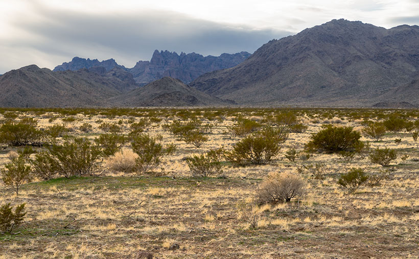
Mt. Tipton Wilderness Area - The jagged peaks in the Mt. Tipton Wilderness Area are at the north end of the Cerbat Mountain Range.
Mt. Tipton Wilderness Area – The jagged peaks in the Mt. Tipton Wilderness Area is at the north end of the Cerbat Mountain Range.

More interesting to me is the Mount Tipton Wilderness Area, which is almost at the northern end of the Cerbat Range. At 7148 Mt. Tipton is the tallest peak, but the wilderness area also has some jagged peaks that made me stop to take this week’s featured image—even though the sun had gone behind the looming storm clouds. I named the photo Mt. Tipton Wilderness, and it shows dried grasses and creosote bush against the barren granite mountains.

On the whole, I enjoyed our drive to Pearce Ferry. There were a lot of beautiful sights found there, and I can see returning in the future to do more serious photography. That’s the downside of these trips. They’re to photography what Cliff Notes are to books. To get the best results, you need to study and understand the subject.

On the other hand, we’ve only begun to explore Arizona’s back roads, and there’s so much more to see. I feel like I wasted the first two-thirds of my adulthood working for a paycheck. However, I understand that I wouldn’t be here if I hadn’t. I hope I have enough time to finish it all.

You can see a larger version of Mt. Tipton Wilderness on its Web Page by clicking here. I hope you enjoy seeing it. Next week I have a surprise for you. Something completely different, so I hope we’ll see you then.

Until next time — jw

Garnet Mountain Picture of the Week

When I was a younger man, I had too many hobbies. Besides photography, I raced cars, fished, listened to music, and gorged on food and wine. Since retiring, we’ve downsized. I’ve given up cars, fishing, and expensive restaurants. We live on a pension now, so photography is my last indulgence—and it’s a good thing that I don’t have to buy film anymore, else I’d have to throw that out the window too.

It took a while to adapt to Arizona living. Sure, half the year is divine, but summers are hell—literally. So, as every good Zonie knows, you head for the hills to escape the heat and humidity of the monsoons. The other option is to close the drapes, lock the doors, and hibernate in front of the telly. As an aspiring angler, I bought a new edition of Bob Hirsch’s Best 100 Arizona Fishing Holes every year. They never changed, but I always read the ink off my copy by the time the Outdoors Show rolled around. I preferred fishing for trout instead of bass, so we’d make our pilgrimages to where the waters were cold: the Mogollon Rim, White Mountains, Lake Powell, or Lee’s Ferry—if the weather was good.

On the trip that Queen Anne and I made to Pierce Ferry for this month’s topic, I kept asking myself, “Why haven’t I been here before? This part of Arizona is beautiful and very photogenic.” I think the simple answer is that there are no trout here, so I didn’t care. Of course, there’s the Black Canyon below Hoover Dam, but it’s 675′ above sea level. That’s lower than Phoenix, and black rocks surround it. Besides, I got skunked on the one trip that we made, so I never went back.

Hualapai Valley, as I said, is Basin-and-Range topography—like Nevada. It’s flanked on the east by the southern end of the Grand Wash Cliffs, while the Cerbat Mountains line the west. The valley floor’s low spot is Red Lake—which is dry most of the year. Orchards surround the lake, but I don’t know how successful they are. Hualapai Valley is also home to a large grove of Joshua Trees, which fills an area about the same size as ours in Yavapai County.

It’s the Grand Wash Cliffs that caught my attention on the map. They’re a long string of mountains—above and below the Colorado River, forming the western edge of the Colorado Plateau. They’re the transition to the Great Basin Desert.

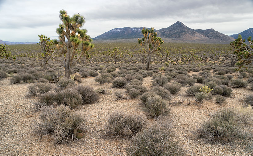
Garnet Mountain - Joshua and sage grow to the foot of snow-covered Garnet Mountain.
Garnet Mountain – Joshua and sage grow to the foot of snow-covered Garnet Mountain.

This week’s featured image, Garnet Mountain, shows Joshua Trees and sage growing to the mountain’s feet. The mountain is over 6,000 ft high and has snow from previous winter storms. The unnamed pointy peak is closer but a thousand feet shorter, so that’s why it’s not snow-capped. Together, they show two of the geological forces that shaped Arizona. Block shapes are generally uplifts caused by plate tectonics, while pointy mountains are usually volcanic. I like what we saw on this visit, so I’m planning a trip to the Colorado River’s north side later this year, but to do that, I’ll need to travel via Utah or Nevada, so I’ll need some slot machine money.

You can see a larger version of Garnet Mountain on its Web Page by clicking here. I hope you enjoy seeing it. Join us next week as we drive home and stop for more photos.

Until next time — jw