Broken Crown Picture of the Week

It takes a lot of space to jam a four-lane freeway through a mountain pass. If you have a horse-drawn wagon, you can squeeze through some tight spots, but with a Peterbilt 579—not so much. You have a couple of options to get that extra width—cut back the mountains or raise the road over them. A more practical approach is to do a little of each. Cut into the hills some and use that fill to raise the road—like how we build today’s modern highways.

The reason I bothered with this engineering exercise is that there are segments of the old Union Pass two-lane road that you can still explore, but they’re maybe 50 feet below the current grade. The more extensive section is on the west side of the Black Mountains crest, which we’ll talk about next week. On the east side, less than a mile of Old SR 68 remains. It’s behind an unlocked ADOT gate meant to keep livestock off of the highway, so be sure to close it after you. The road-gate is the public access to the old Richardson Homestead—a one-family ghost town.

The Richardsons were a family of five who settled the homestead in 1897. When they claimed the 160 acres, it had spring water, enough flat land for an orchard, vegetable garden, and a horse barn left behind by Union Troops stationed there to protect travelers from hostile Indian tribes. In summer, they made the journey from Los Angeles in a covered wagon pulled by a pair of horses.

They moved after John’s doctor told him to “go live in the desert.” I didn’t find a reference to John’s ailments, but that was a standard remedy for tuberculosis back then. The clear desert air undoubtedly helped him because John and his wife, Victoria, built a two-story home, root-cellar, planted trees, and raised livestock using only their sweat and simple hand tools. After establishing their home, Mohave County paid them a monthly allowance to maintain—what was then known as Beal’s Wagon Road—three miles in each direction. For thirty-eight years, they welcomed weary travelers with fresh fruits, preserves, vegetables, cold water, and a place to spend a night.

Victoria succumbed to cancer in 1935—four years after their fiftieth wedding anniversary. John followed five years later. Today they rest side by side in Kingman’s Mountain View Cemetery on Stockton Hill Road.

If you can call middle-aged adults kids, they managed the ranch and changed to keep up with the times. They added guest cabins, a small store, and a gas station. The family enterprise lasted until 1984. We, like our parents before us, didn’t have time to stop at some old place along the road. We had places to go. Shortly after that, the last of the family gave up the land, and the BLM took back ownership.

I remember the Richardson Homestead as a shady oasis on the drive between Kingman and Bullhead City. We would do the long climb from the river, and soon after cresting the hill, tall trees shaded the old road. The collection of rock-wall buildings and weathered metal roofs were always a  blur as we sped past. I vividly recall one early morning return trip. I remember the time because of the golden light. After we passed the old gas station, we saw real-live cowboys on horses driving cattle down the hill on the roadside. My companion and I laughed out loud because we had never seen working cowboys in Arizona—just the plastic ones that hang out in Scottsdale.

Broken Crown - A crown of tuff rests on a layer of basalt in Union Pass.
Broken Crown – A crown of tuff rests on a layer of basalt in Union Pass.

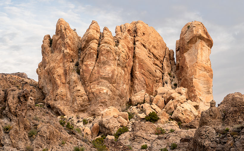
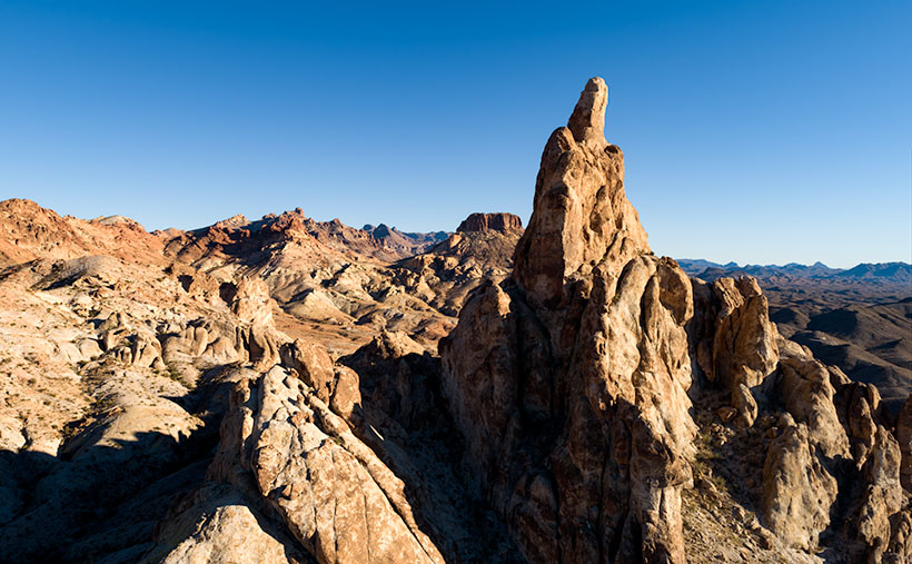
When I pulled over and stopped Archie to shoot this week’s picture, it was beside the homestead. Before I ran across four lanes of traffic (it was very early sun-up and no one was on the road yet), I looked over the guardrail at the remaining ruins and blew them off. I wasn’t out house hunting. Instead, I opted to focus on rocks (pun intended). This large outcrop of tuff on top of a basalt layer was just the ticket. I call this image, Broken Crown because of the fresh rock-fall and truck-sized boulders on the right. But, now that I know about the Richardson family, I want to return soon and wander among the remaining ruins with my camera.

You can see a larger version of Broken Crown on its Web Page by clicking here. Please come back next for our final image in this series and the story that goes with it.

Until next time — jw

Thumb Butte Picture of the Week

Arizona State Route 68 in Mohave County has substantially improved since I first visited Bullhead City decades ago. It was a two-lane back road with faded markings and crumbling tarmac. When it rained, it was impassable because the highway ran through the flooded wash bottoms. These days, it’s a mini-interstate with four lanes and no lights or signs along its 28-mile length. It’s impressive how infrastructure improves when it involves getting people into casinos.

SR 68 also has one of the best views of all the roads I’ve traveled. That vista comes just west of Union Pass in the Black Mountain Range. When you see the Union Pass elevation sign (3570 feet), you can tell it’s coming. There is a wide shoulder here to enable truckers to safety-check their brakes. Immediately after you clear the mountains on either side of the highway, you can see a panoramic view of the Colorado River 3000′ below. Beyond the blue water ribbon, you can see into the Nevada Desert going on forever—especially now that APS has dismantled the coal-fired Mohave Power Station. You don’t have long to enjoy the view because suddenly you’re on the downhill side of the roller coaster, and just for giggles, the highway department put a stoplight at the bottom of the 11 miles of 7% grade.

Thumb Butte - An 800' tall granite monolith overlooking the Colorado River above Bullhead City.
Thumb Butte – An 800′ tall granite monolith overlooking the Colorado River above Bullhead City.

As you descend into the river valley, a thing that jumps out at you is an 800′ tall granite monolith on the left side of the road. It’s called Thumb Butte on the maps, but many locals call it Finger Rock. It’s visible in both towns—Bullhead City and Laughlin—and from there, it looks like the universal gesture of ill will, the big bird, the highway salute, or whatever your favorite euphemism for the middle finger is. (There is another landmark a couple of miles south officially named Finger Butte—don’t confuse the two.)

I have wanted to photograph the rock before, but my schedule prevented me from stopping. On this year’s trip, I decided to make time. I watched videos, poured over the Topo maps, and found a Jeep Trail that goes right by the tower. So, late afternoon, Archie and I drove the dirt trail and took this week’s photo, which I call Thumb Butte.

I wanted to capture some depth and texture, so I shot the rock from the north side, looking into the Mount Nutt Wilderness Area. I’m happy with how this image captures the rugged terrain of the Black Mountains—if only a tiny sample. Maybe I should regularly go back and work the entire range—from Needles to Hoover Dam. What do you think?

You can see a larger version of Thumb Butte on its Web Page by clicking here. Please return next week when I show another photo from Union Pass and SR 68.

Until next time — jw

Burro Creek Bridge Picture of the Week

I had been asleep for an hour when Queen Anne finally came to bed last night. She nudged me until I almost woke and snapped, “What?”

“It’s raining,” she gleefully said.

I rolled over, pulled the covers up, and tried to go back to sleep while grunting, “Harrumph.”

“It’s pouring,” she persisted.

“Why are you waking me?”

“You’re snoring,”

I was too sleepy to recall accurately what happened next, but I think she bumped her head because she went to bed and didn’t get up till morning. I swear that’s the actual conversation we had last night.

This year’s monsoon season is unlike the drought that we had last year. We’ve been enjoying a week of cloudy skies, isolated showers, and last night’s low was under 70°. It wasn’t that pleasant autumn-like 68° where you can throw open the doors and windows. It was 68° with 95% humidity—which is cool only if you have gobs of air blowing at you—aka swamp cooler. But still, we have a decent river flowing down the street out front and the Red Sea in our backyard. The two trellis vines out front that have spent last year imitating Paul Rubin’s death scene in Buffy the Vampire Slayer—are already sprouting fresh green shoots.

All in all, it’s been a good monsoon so far, and they say there’s more to come. I lament the wasted rainwater flowing down the streets. There should be a way to capture some of it and store it for a (forgive me) non-rainy day. The runoff flows down the washes and eventually into the Gila River, where the Gila Bend and Yuma farmers use it for their crops.

I’ll bet if I revisited Burro Creek—last week’s featured image—it would look like a proper creek instead of a string of puddles. I’m not going to risk a possibility of getting caught in a flash flood. Arizona has a Stupid Driver law now, and with my luck, I’d be the first person to get billed for my rescue. Instead—as I promised last week—I’ll turn the camera around so that you can see what’s downstream.

Burro Creek Bridges - A pair of future freeway bridges cross Burro Creek before Greenwood Peak.
Burro Creek Bridges – A pair of future freeway bridges cross Burro Creek before Greenwood Peak.

The subject of this week’s image is a pair of freeway bridges over Burro Creek, waiting for Interstate 11. Don’t be fooled into believing that this is an empty highway. U.S. 93 is normally a bustling traffic corridor. It’s just that my image was taken just after dinner when the freight drivers are still belching in truck stops.

You can see a couple of other things in the photo and another hidden by the bridge. First—under the bridge—are the deep pools in the creek. They’re wet all year round, so they have small fish in them. The minnows are useless to anglers, but they support a colony of Great Blue Herron that nest along the canyon walls.

Along the horizon is the 4,339 foot high Greenwood Peak. I have another shot of this mountain that was featured in a January 2020 post. During that month, Anne and I drove over the pass to the mountain’s left and, at the bottom, we found the road blocked by water flowing in the Big Sandy River. In that article, we remarked how the slopes of the Poachie Range were covered with saguaro and pinion pines growing next to one another.

Finally, what’s hidden behind the bridges is the Burro Creek Campground. It’s smallish with quiet camping spots until a loaded semi drives over the bridge’s expansion strips—the noise echoes along the canyon walls like Gilbert Godfrey with a megaphone. However, if you’re into history, the campground’s access road is the original two-lane highway that winds its way down the canyon, crosses the creek on a  low bridge, and then ascends the north face.

You can see a larger version of Burro Creek Bridge on its Web Page by clicking here. I have to come up with a creative idea for August, so please come back and see what I’ve come up with. For now, I’m going to don my galoshes and go stomp in some puddles.

Until next time — jw

Burro Creek Canyon Picture of the Week

There is the phrase Grand Canyon State on every Arizona license plate—it’s our state slogan. I find it ironic that the biggest thing we brag about is something that eroded millions of years ago. Sure, we have the World’s biggest hole in the ground, but there are many other sights in Arizona that we can be proud of.

I think that the slogan can have two meanings. First is obvious; the Grand Canyon State—we’re the state where the Grand Canyon is. The other interpretation that I see is; the grand canyon state—meaning that we’re a big state with lots of canyons within it. It’s true. We have pretty canyons all over the state. There’s the big ditch, of course, but there is also Canyon de Chelly, Salt River Canyon, Oak Creek, Madera Canyon, Sabino Canyon, and too many others to list here. Actually, I looked for a comprehensive list like the one I found for our mountains, but it alluded me.

Burro Creek Canyon - An awesome view that most people miss because they're in a hurry to get to Vegas, or back home.
Burro Creek Canyon – An awesome view that most people miss because they’re in a hurry to get to Vegas or back home.

Our stop this week along Highway US 93 is Burro Creek Canyon. The view of the canyon is spectacular, but it’s hard to see from the road. The bridges over the chasm are short, and the walls are high, so unless they’re in a semi-truck, most people don’t get to see over them—a gripe I share with the new bridge at Hoover Dam. The highway department didn’t build a scenic overlook, and you’re not supposed to walk across the bridge. You can take in the vista in my shot by parking in an unmarked lot accessible from the northbound lanes. Then, a short hike up a trail will get you to the south wall.

Canyons have always been important to Arizona travelers because you usually find water in them. After all, that’s how they were carved. Burro Creek is one of those exotic desert waterways that always has water (in normal years). As you can see in my shot, a couple of surface pools reflect the blue sky even during our extended drought. That makes the creek a reliable water source for wildlife, cattle, and even the wild burros that are pervasive in western Arizona.

I’ve considered adding canyons to my projects list. There’s enough subject matter to fill another of my book fantasies. However, my to-do list already has mountains, old towns, historic hotels, deserts, farms, Colorado Plateau, and the Grand Canyon on it. How do I prioritize them? Where would I ever find the time to photograph them all? I’d have to clone myself because my time is getting short, and the list keeps growing.

You can see a larger version of Burro Creek Canyon on its Web Page by clicking here. Next week, I’ll turn the camera around for a nice look in the other direction.

Until next time — jw

Warm Springs Cholla Picture of the Week

This morning, when I got out of bed and looked in the bathroom mirror to see if I still had a reflection, I scared myself. What little hair that I still have was standing perpendicular to my head. I think I stuck my finger in a light socket last night. I’m puzzled at how the remaining five hairs on the top of my head—which are invisible when I comb them—manage to stick straight up like a coastal lighthouse. A less intelligent Albert Einstein stared back at me. I need a haircut.

When I got out of the Army, I had thick wavy red hair, and I went to a salon every other week to get it styled. I was on the hunt for a mate back then, so I had to look my best. I patronized one of those places that charged more because they cut your hair with a razor. I paid $30 for a wash, cut and blow-dry. I spent too much time each day trying to get that Glen-Campbell-look that was popular then. Then came the 70’s, and we just let our hair grow long. When my hair curled over my ears like Bozo the Clown, it was time to go to Floyds.

I turned gray when I was in my thirties, and suddenly I was an old man. As my hairstyle paid fewer dividends, I gave up and started combing it straight back. I only got a haircut three or four times a year, whether I needed it or not. Now I visit the barber when we make a Mexican pill-run. It’s cheaper there, and—because I’m a senior—I get a discount. The tip is more than the cut, and I still get change. I don’t even care what it looks like as long as it’s shorter than when I walked in.

We’ve suspended our trips to Algodones during this pandemic, so I’m taking matters into my own hands. I ordered hair-clippers from Amazon. They were supposed to be here on Friday but didn’t arrive. I’ve worked up the nerve to let Queen Anne put it on the shortest setting and shave it all off. How bad could it be? Besides, that’s why I have hats.

The day that Queen Anne and I traveled down Old Route 66 was the exact opposite of a ‘bad hair day’ (see how I did that?). The trip produced more good images than I usually get, and with good reason. The Black Mountain Range is an exciting pile of rocks. I can see me spending more time exploring them—especially when one of you coughs-up the funds for my hover-bike.

Warm Springs Cholla - Cholla along the roadside provide a good foreground contrast for McHeffy Butte at sunset.
Warm Springs Cholla – Cholla along the roadside provides an excellent foreground contrast for McHeffy Butte at sunset.

This week’s featured image is called Warm Springs Cholla. As you can tell from the colors, I took it as the sun was setting. We were several miles south of Oatman, and I was studying a  peak—McHeffy Butte—as we drove along. Suddenly (ta-da), a patch of cholla popped up, making a perfect foreground. After I stopped the truck, I hiked a short distance uphill into the Warm Springs Wilderness and fired off a couple of shots. I think the resulting image makes a great wrap-up to our Route 66 trip.

You can see a larger version of Warm Springs Cholla on its Web Page by clicking here. I hope you enjoy it. Next week is June and another back road adventure. I hope you’ll come back and hear about our road trip.

Until next time — jw