Cup Holders Picture of the Week

I will pause our Snow Canyon State Park tour for a couple of paragraphs so we can run over to the coast. Don’t worry; we won’t have to put up with any of those weird Californians. Where we’re going, they don’t exist yet. We’re not traveling far—maybe a foot or two. However, we are breaking every law in physics to travel back one-hundred-eight million years ago—to the Jurassic era. You can turn around now and take in the Sundance Sea, right here in southern Utah (how old is Robert Redford anyway). Don’t go in the water. Big things in there will eat you like you’re a gummy bear.

Turn back this way and look down the shoreline. Massive dunes—hundreds of feet high—go on for hundreds of miles. Until now, it’s been hot and dry here along the Equator, but the climate is changing. It’s becoming muggier and swamp-like. The oceans are rising, and soon (in geological time), the water will cover the sand and pile more sediment. The pressure on the dunes will bind them into stone—never to be seen again.

Things would have stayed that way, except our stupid captain rammed the North American plate into the Pacific Plate, and there goes the neighborhood. The crash spun us around and raised the Rockies, the Sierra Nevada, and all the other little wrinkles in between. The resulting damage cracked the mantle so badly that volcanoes could form, raising the Colorado Plateau. Then the Californians move in—can it get any worse?

The crash shoved our peaceful little seaside village up a hillside. We no longer live in a basin where sediments collect. Now, our water flows to a place far away. It peels back layers of rock—like an onion when it does. After erosion uncovers parts of the great dunes, we’ll see them again here in St. George, Zion, and north of Escalante. Now they’re as hard as a rock.

Dune Walkers - About the only way you can stay on the Petrified Dune Trail is to go on a guided hike, like these people.
Dune Walkers—The only way to stay on the Petrified Dune Trail is to go on a guided hike like these eight people.

You can snap out of it now and return to reality, where we’re standing on the Petrified Dunes Trail. Because it’s all rock, the only clue you have to follow is the path worn smooth from countless boots. It’s easy to leave it, but that’s fine because you won’t damage anything. The rock grips like sandpaper, making it easy to scramble up and down the slopes. As you wander across the uniformly fractured rock, you examine the exceptions.

Cup Holders - Freezing water bores into the sand stone and will over time reduce the rock to sand grains.
Cup Holders – Freezing water bores into the sandstone and reducing the rock to sand grains over time.

That’s how I found this week’s picture. The round wells in the picture are places where water is collected and has a chance to freeze. As the ice expanded, it fractured the sandstone and chipped it. These spots get deeper; they’ll hold more water and bore into the stone faster. Eventually, they’ll be so deep that they’ll split the block until it reverts to sand grains. I think the shapes of the cups are fantastic, but I like the rich and varied colors in the stone. When you look closely at this, sandstone has a lot of depth and texture.

Click here to see a larger version of Cup Holders on its Web Page. Come back next week when I’ll tell you about how the stupid captain left the kettle on too long and spilled hot lava all over the park.

Until next time — jw

Arch and Honeycomb Weathering Picture of the Week

When you were a child and thunder was new to you, did your mother try to console you by explaining that the noise was just God and the angels bowling in heaven? My mom did that. I believed her because she’d never lie to me, and she knew I’d catch her (although I don’t understand why Santa stopped sending me $20 at Christmas when she died). She always told people that I was their peer, although there may be more intelligent children. Well, what her exact words were is, “He sure ain’t the brightest kid in the class.”

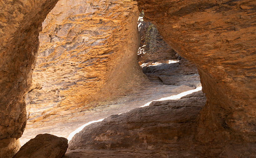
Arch and Honeycomb Weathering - inside the cave on the Jenny's Canyon Trail are a natural window and Honeycomb Weathering.
Arch and Honeycomb Weathering -Inside the cave at the end of Jenny’s Canyon Trail are a natural window and Honeycomb Weathering.

This memory comes to mind because I think I’ve captured the scoreboard that the angels used. It’s visible in this week’s picture—the rows of distorted cribbage holes. If one of the bowlers threw a strike, a lightning bolt would cause a tree to burst into flames. Then they’d advance their marker into the next hole. The one that got their rock in the last spot won. It’s that simple.

I did a lot of online research to prove my thesis, but I found nothing. Instead, the experts call this kind of erosion honeycomb weathering. It’s not clearly understood, but it’s an alchemy of rock, salt, rain, freezing, and expansion. You also have to hold your tongue just right while you’re making it. I saw this type of erosion before in Canyonlands National Park when we visited too long ago, so I assume that it’s shared across Southern Utah’s sandstone formations.

This example of honeycomb weathering is in Utah’s Snow Canyon in a place they call Jenny’s Canyon. It’s at the end of a half-mile (round trip) trail near the park’s south entrance, and it was the shortest and the most rewarding of the side trips that we took. The trail leads to a slot canyon in the sandstone, but not the usual slot. Unlike Antelope Canyon near Page—where running water has cut a course into the sandstone—this is one of those stacked dunes (see last week’s picture) with a gap between the layers. Jenny’s Canyon begins as a typical slot, but dead ends in a short cave. I took my shot from inside the cave.

If you think some weird bacteria are growing on the cave walls, let me explain the color. Like wearing a pair of rose-colored glasses, when the sunlight bounces off the red sandstone, it adds that color to the reflected light, and that’s why the back wall seems to glow orange. Other photographers have successfully captured this phenomenon at Bryce Canyon, but I’ve been unlucky so far. “Damn you, Bryce. I’ll get you one day.”

Jenny's Canyon Sky - Because the canyon walls almost touch, the view of the sky is a narrow ribbon in Jenny's Canyon.
Jenny’s Canyon Sky – Because the canyon walls almost touch, the view of the sky is a narrow ribbon in Jenny’s Canyon.

The second image that I included to illustrate my post is the sky from Jenny’s slot canyon. I’ve seen photos like this, and I wanted one of my own. I think the blue against the glowing orange and dark walls look like torn craft paper glued on one another as a collage. I consider it an abstract because it has no story of its own.

You can see a larger version of Arch and Honeycomb Weathering on its Web Page by clicking here. Come back next week to see the next trail that we explored. It’s not far up the road.

Until next time — jw

Stacked Arches Picture of the Week

Queen Anne and I drove out of the Sonoran Desert to the frozen north this week. No, I don’t mean Alaska or even Canada, but the land of young men dressed in white shirt black tie uniforms that ride bikes in pairs and come to redeem your soul—and don’t even bring cookies to sell. Of course, I’m talking about Utah. When we arrived, we found the same weather we had at home. It’s December—what happened to the snow?

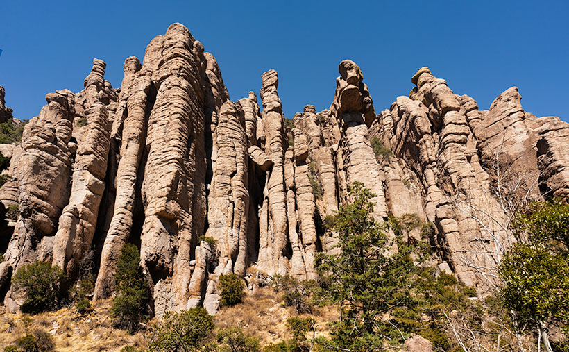
Stacked Dunes - Petrified dunes stacked like records in a jukebox for the western wall of Snow Canyon State Pare in St. George, Utah.
Stacked Dunes – Petrified dunes stacked like records in a jukebox for the western wall of Snow Canyon State Park in St. George, Utah.

We made the five-hour drive to St. George specifically for this month’s project. A couple of years ago—after I published my State Route 12 magazine—one of my cronies said, “Have you been to Snow Canyon. You ought to go—it’s beautiful.” I had never heard of it, but I was impressed enough to add it to my destination list after doing some online research.

I love shooting on the Colorado Plateau, which takes up most of Utah and the excess spills into neighboring states. People have even complained I spend too much time shooting there. Much like a wine snob will order a glass of ABC (Anything But Chardonnay). But, the plateau is addictive for me. It’s too easy to get compelling images there, and you all know how lazy I am.

St. George is along Interstate 15 (initially a Mormon trade route), at the western edge of the Colorado Plateau. It’s a pretty community nestled among several mountain ranges, but we’ve never spent time there for a couple of reasons. First, we only passed through to somewhere else, and second, on our honeymoon, I had to stop and buy a tire there … on Sunday … at a Chevron station because the whole state closes on the Sabbath.

The town has changed over the last 33 years; from an agricultural center to a full-blown resort. The downtown, around the Temple, still has an old mid-west charm, but the mansions that line the cliffs and surround Snow Canyon are right out of Aspen, Snow Mass, or Sedona. Utahans see St. George as their Riviera, so there seems to be a rush to build a second home there. The views are essential, so they’re stacking McMansions side by side along the ridgelines. Their views must be spectacular, but from below, it’s vulgar.

In the middle of this wealth and consumption is Snow Canyon State Park. Originally called Dixie State Park, officials created it in 1959 by combining donated BLM land with a $20,000 ranch purchase (sigh). The state later changed the name to honor Mormon elders. You probably have seen it if you’ve watched Butch Cassidy, Jeremiah Johnson, or the Electric Horseman movies. The entry fee is $8.00, and there are over 30 campsites available starting from $30.00 a night.

My first impression of Snow Canyon was, “Gee, this is small.” The north-south road is approximately 11 miles between the two entrances. But, the park floor climbs a thousand feet in that distance, and there are 12 hiking trails along its length. Packed into that relatively small area is a miniature version of the Escalante Grand Staircase. At the bottom is the reddish-orange sandstone layer common to Kanab, and that’s topped with white Navajo Sandstone as you see in Zion National Park. Black lava flows are mixed with the colorful sandstone, and Signal Mountain provides a grand backdrop. There’s enough to photograph within the park’s boundaries to fill a small picture book (hmmm, there’s an idea).

This week’s picture is a teaser. I took it from the park’s top looking south at petrified dunes stacked up like records in a Wurlitzer jukebox, so I called it Stacked Dunes. The dunes are along the park’s west wall and rise a thousand feet above the valley floor. I couldn’t help but dot the sky with some happy little cirrus clouds as icing. Can you blame me?

You can see a larger version of Stacked Dunes on its Web Page by clicking here. Come back next when we show you pictures of the trails we explored (that’s right, I got Anne out of the truck and down a trail). We’ll start at the park’s south for December and work our way north. It’ll be fun.

Until next time — jw

Sunset Wall Picture of the Week

Alright, class, settle down. Get out a sheet of paper and a pen, then put away your backpacks. Today we’re starting with a pop quiz. There is only one question, and you have 15 minutes to answer with 10,000 words—or more. You must cite your sources. Spelling and punctuation will be graded. Are you ready? Your question is, “What do Memphis, Tennessee, and Kingman, Arizona have in common?”

I have talked before about old trading trails morphing into the well-laid-out highway system that we have today. Most of us don’t care how it happened, and we just drive on them. They think that Eisenhower signed a paper in 1956, and the freeways just popped into existence. I think that’s because people younger than me—and that’s pretty much everybody—didn’t experience the change first hand. Our forebearers built most roads over existing paths, and there are reasons someone blazed those original paths. Mark Knopfler describes this phenomenon well in his 1982 song Telegraph Road from the Dire Straits album Love Over Gold.

There have been trading trails across Northern Arizona since the first Pueblo inhabitants. European settlers didn’t use them much because the New Mexico territory was Spanish. Their roads came up from Mexico to towns like Santa Fe and the Old Pueblo at Tucson. Those roads followed the Rio Grande and Santa Cruz Rivers because there was always reliable water. The rest of the desert was a wasteland. What changed that? It was gold.

In 1848, James Marshall discovered gold at Sutter’s Mill in California. In less than two years, California became a state—that’s instantaneous in government time. They needed to move goods and people to the Golden State—and get the gold back to Washington. But, there were no east-west roads, so they put Captain Lorenzo Sitgreaves in charge of a surveying expedition, and he laid out a railroad route around the 35th Parallel.

Then in 1857, the Fed’s paid Edward (Fitzgerald) Beale to build a wagon road from Ft. Smith, Arkansas, to Los Angeles—again along the 35th Parallel (remember, Tucson was still in Mexico). He built his road in a year using camels because they needed less water and food than oxen and horses. By all accounts, it wasn’t much of a road, but Beale bragged that it was the shortest route by 300 miles and “It is the most level: our wagons only double-teaming once in the entire distance, and that at a short hill . . .” His road became the Santa Fe line in 1880, then Route 66 in 1926, and finally Interstate 40 in 1978.

SR 68 through Union Pass - Arizona State Route 68 (on the right) as it enters Union Pass through the Black Mountain Range.
SR 68 through Union Pass – Arizona State Route 68 (on the right) as it enters Union Pass through the Black Mountain Range.

His wagon road wandered a bit from the 35th as it meandered across the desert, but wagon tracks are visible in places on Google Earth. As vehicles became more efficient, each of the subsequent roads shortened its length. Some silly people hike the old road just for giggles. I’m not that ambitious. However, I do know of a place where you’ll be in Ed’s footsteps. Yep, you guessed it. It’s our Union Pass on SR 68. While Sitgreaves went through Oatman, Beale found a more accessible way to Fort Mohave and his river crossing.

Sunset Wall - Layers of volcanic rock upended vertically in the Black Mountain Range.
Sunset Wall – Layers of volcanic rock upended vertically in the Black Mountain Range.

I took this week’s picture on the west side of Union Pass, and it shows layers of lava and ash (tuff) that have been turned horizontal by geological forces. As Don Sprinkle commented in another post; “. . . just like the Grand Tetons.” It was sundown as I took this photo, and that’s why the ordinarily dark rock has a beautiful red glow, and that’s why I called it Sunset Wall.

So, back to your quiz; I’m going to let you grade your papers. What did you answer to: What do Memphis, Tennessee, and Kingman have in common? If you said that they are both along Interstate 40, you get 50%, and if you said that they both have a Beale Street, you get another 50%. I must add that there is a difference too. While Kingman knows who they named their street after, according to the Wikipedia entry for Memphis’ Beale Street, nobody remembers who Edward Beale was, which I find amusing. Maybe it’s forgotten because he was a Union Naval officer.

You can see a larger version of Sunset Wall on its Web Page by clicking here. Please come back next when we begin December’s project and new pictures.

Until next time — jw

Broken Crown Picture of the Week

It takes a lot of space to jam a four-lane freeway through a mountain pass. If you have a horse-drawn wagon, you can squeeze through some tight spots, but with a Peterbilt 579—not so much. You have a couple of options to get that extra width—cut back the mountains or raise the road over them. A more practical approach is to do a little of each. Cut into the hills some and use that fill to raise the road—like how we build today’s modern highways.

The reason I bothered with this engineering exercise is that there are segments of the old Union Pass two-lane road that you can still explore, but they’re maybe 50 feet below the current grade. The more extensive section is on the west side of the Black Mountains crest, which we’ll talk about next week. On the east side, less than a mile of Old SR 68 remains. It’s behind an unlocked ADOT gate meant to keep livestock off of the highway, so be sure to close it after you. The road-gate is the public access to the old Richardson Homestead—a one-family ghost town.

The Richardsons were a family of five who settled the homestead in 1897. When they claimed the 160 acres, it had spring water, enough flat land for an orchard, vegetable garden, and a horse barn left behind by Union Troops stationed there to protect travelers from hostile Indian tribes. In summer, they made the journey from Los Angeles in a covered wagon pulled by a pair of horses.

They moved after John’s doctor told him to “go live in the desert.” I didn’t find a reference to John’s ailments, but that was a standard remedy for tuberculosis back then. The clear desert air undoubtedly helped him because John and his wife, Victoria, built a two-story home, root-cellar, planted trees, and raised livestock using only their sweat and simple hand tools. After establishing their home, Mohave County paid them a monthly allowance to maintain—what was then known as Beal’s Wagon Road—three miles in each direction. For thirty-eight years, they welcomed weary travelers with fresh fruits, preserves, vegetables, cold water, and a place to spend a night.

Victoria succumbed to cancer in 1935—four years after their fiftieth wedding anniversary. John followed five years later. Today they rest side by side in Kingman’s Mountain View Cemetery on Stockton Hill Road.

If you can call middle-aged adults kids, they managed the ranch and changed to keep up with the times. They added guest cabins, a small store, and a gas station. The family enterprise lasted until 1984. We, like our parents before us, didn’t have time to stop at some old place along the road. We had places to go. Shortly after that, the last of the family gave up the land, and the BLM took back ownership.

I remember the Richardson Homestead as a shady oasis on the drive between Kingman and Bullhead City. We would do the long climb from the river, and soon after cresting the hill, tall trees shaded the old road. The collection of rock-wall buildings and weathered metal roofs were always a  blur as we sped past. I vividly recall one early morning return trip. I remember the time because of the golden light. After we passed the old gas station, we saw real-live cowboys on horses driving cattle down the hill on the roadside. My companion and I laughed out loud because we had never seen working cowboys in Arizona—just the plastic ones that hang out in Scottsdale.

Broken Crown - A crown of tuff rests on a layer of basalt in Union Pass.
Broken Crown – A crown of tuff rests on a layer of basalt in Union Pass.

When I pulled over and stopped Archie to shoot this week’s picture, it was beside the homestead. Before I ran across four lanes of traffic (it was very early sun-up and no one was on the road yet), I looked over the guardrail at the remaining ruins and blew them off. I wasn’t out house hunting. Instead, I opted to focus on rocks (pun intended). This large outcrop of tuff on top of a basalt layer was just the ticket. I call this image, Broken Crown because of the fresh rock-fall and truck-sized boulders on the right. But, now that I know about the Richardson family, I want to return soon and wander among the remaining ruins with my camera.

You can see a larger version of Broken Crown on its Web Page by clicking here. Please come back next for our final image in this series and the story that goes with it.

Until next time — jw

Thumb Butte Picture of the Week

Arizona State Route 68 in Mohave County has substantially improved since I first visited Bullhead City decades ago. It was a two-lane back road with faded markings and crumbling tarmac. When it rained, it was impassable because the highway ran through the flooded wash bottoms. These days, it’s a mini-interstate with four lanes and no lights or signs along its 28-mile length. It’s impressive how infrastructure improves when it involves getting people into casinos.

SR 68 also has one of the best views of all the roads I’ve traveled. That vista comes just west of Union Pass in the Black Mountain Range. When you see the Union Pass elevation sign (3570 feet), you can tell it’s coming. There is a wide shoulder here to enable truckers to safety-check their brakes. Immediately after you clear the mountains on either side of the highway, you can see a panoramic view of the Colorado River 3000′ below. Beyond the blue water ribbon, you can see into the Nevada Desert going on forever—especially now that APS has dismantled the coal-fired Mohave Power Station. You don’t have long to enjoy the view because suddenly you’re on the downhill side of the roller coaster, and just for giggles, the highway department put a stoplight at the bottom of the 11 miles of 7% grade.

Thumb Butte - An 800' tall granite monolith overlooking the Colorado River above Bullhead City.
Thumb Butte – An 800′ tall granite monolith overlooking the Colorado River above Bullhead City.

As you descend into the river valley, a thing that jumps out at you is an 800′ tall granite monolith on the left side of the road. It’s called Thumb Butte on the maps, but many locals call it Finger Rock. It’s visible in both towns—Bullhead City and Laughlin—and from there, it looks like the universal gesture of ill will, the big bird, the highway salute, or whatever your favorite euphemism for the middle finger is. (There is another landmark a couple of miles south officially named Finger Butte—don’t confuse the two.)

I have wanted to photograph the rock before, but my schedule prevented me from stopping. On this year’s trip, I decided to make time. I watched videos, poured over the Topo maps, and found a Jeep Trail that goes right by the tower. So, late afternoon, Archie and I drove the dirt trail and took this week’s photo, which I call Thumb Butte.

I wanted to capture some depth and texture, so I shot the rock from the north side, looking into the Mount Nutt Wilderness Area. I’m happy with how this image captures the rugged terrain of the Black Mountains—if only a tiny sample. Maybe I should regularly go back and work the entire range—from Needles to Hoover Dam. What do you think?

You can see a larger version of Thumb Butte on its Web Page by clicking here. Please return next week when I show another photo from Union Pass and SR 68.

Until next time — jw

Sycamore Point – and – Calendars     Picture of the Week

Trick or Treat
smell my feet
give us something good to eat

Since this is my first-ever Halloween post, I couldn’t pass that up.

So, where were we? Oh yes—Queen Anne and I spent an afternoon exploring and photographing along the back roads to Sycamore Point. The sun was going down, and we wanted to get back to Williams to have a nice dinner at The Red Raven Restaurant.  Before we leave, let me get in one more shot.

Sycamore Point - From Sycamore Point, looking back over Thumb Flat to Bill Williams Mountain.
Sycamore Point – From Sycamore Point, looking back over Thumb Flat to Bill Williams Mountain.

I call this week’s photo Sycamore Point. If it isn’t apparent, I took it with my drone. Unlike a normal camera, you can’t spontaneously whip it out and start flying about—well, not if you want to keep your license. You have to file a flight plan, conduct a pre-flight check, and there are no fly areas. In this case, I couldn’t fly it past the wilderness boundary (you can get an exception from the BLM—but that takes weeks).

The truth is that I took several drone shots of the canyon, but because the drone’s camera lens is ultra wide, the images from my Sony were better, so I used those. Since the drone had battery time left, I turned it around and pointed the camera toward the road we traveled. From an altitude of two-hundred feet, this is the image that I got.

When I started processing this photo, I realized that it has everything that we’ve been talking about during October. In one image I see Alligator Juniper, patches of yellow wildflowers, Thumb Flat, the edges of Sycamore Canyon, burn scars, the back road, shafts of sunlight, and in the distance, the Northern Arizona Volcanic Field—including Bill Williams Mountain (center left) and The San Francisco Peaks (far right). It’s like you’re back in school, and here’s the chapter review before the test—but from a different perspective.

You can see a larger version of Sycamore Point on its Web Page by clicking here. Next week, it’s time for a new project from a different location. You’ll want to come back and see what trouble I got myself into this time.

Calendars

This year is hurtling to an end already, so it’s time for me to make new calendars. In spite of the extra cost last year we got a nice response. Inflation has taken a toll again this year. After reviewing my printer’s price list and post office shipping costs, I need to charge $20.00 for them. I know that cost is prohibitive to most of you, but they’re a limited item. I need to get one for myself and if you’re interested, I’ll print a copy for you.

The pictures for the 2022 edition are from this year’s outings. The size remains the same—6 ½ inches high (each half—about the size of a sheet of paper folded in half) and 8 ½ inches wide, and they have holidays noted on the dates. They’re printed on card stock—which is part of the expense.

In order to get them to you for Christmas (and we’re cutting it close according to the Post Office), I need to know by November 10th. If you’d like one, you can leave a comment in this post, use the contact form on my website (https://www.jimwitkowski.com/junk/index.php), or email me directly. Don’t forget to leave your contact information if I don’t already have it.

Until next time — jw