Date Creek and Tres Alamos Picture of the Week

Working during the summer is challenging, whether in house chores or photography. That’s why my favorite pastime during these months is procrastination. Face it; I’m allergic to heat. Thinking about going outside is worse than actually doing so. After all, in today’s southwest, we’ve learned to minimize our heat exposure. We move about in a succession of air-conditioned cocoons.

Heat is why I had difficulty coming up with a theme for  July. The monsoons haven’t kicked in yet, so most pleasant campsites are on fire or closed. I must stay close to home, venturing early or after dinner, find a shot, and then hurry home.

I decided that July’s theme will be U.S. Highway 93. That’s the main thoroughfare near my house that Phoenicians (and Tucsonans) use to commute to Las Vegas. The route goes to Canada, but I’m only concerned about day trips. Because I’ve often traveled the section between here and Kingman, I know a few vistas I wanted to capture on film but never had time to stop. This week’s image is an example.

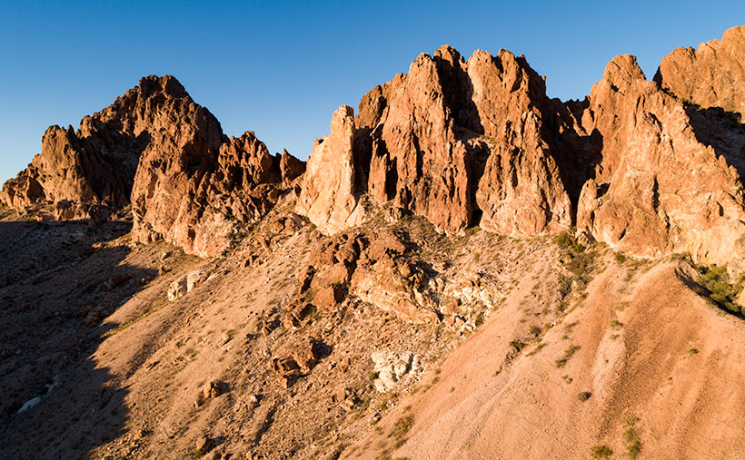
Date Creek and Tres Alamos - Date Creek as it flows by the Tres Alamos Wilderness Area near Congress, Arizona.
Date Creek and Tres Alamos – Date Creek flows by the Tres Alamos Wilderness Area near Congress, Arizona.

North of the SR 71 – 93 junction, the Alamo-Congress Rod is a lousy shortcut to Alamo Lake. It’s a broad dirt road that gets graded annually at best. It passes the Tres Alamos Wilderness Area about 10 miles west of the paved highway. It’s a small nature preserve (83,000 acres) compared to the neighboring Arrastra Mountain Wilderness (129,800 acres). The high point on which Tres Alamos is centered is the 4257-foot Sawyer Peak. To reach the spot where I took this shot, I had to slowly travel a couple of miles on a Jeep trail that left Archie with some Arizona Pinstripes—a badge of honor for a Luxo-SUV.

The wash in this shot is Date Creek, which should be familiar to regular readers because Congress—and the old Congress Gold Mine—are located next to the mountains of the same name. As it were, the creek flows from the Weavers, along the north side of the Date Creeks, to where it merges with the Santa Maria River upstream from Alamo Lake.

An interesting thing in the photo is the tire tracks in the sand. With the rising popularity of those all-terrain buggies, it’s easier for off-roaders to drive through the washes. Most of the time, the ride is smoother than the so-called mine roads. However, in the past, you could see tracks of the animals crossing the river bottoms. It was a visitor guest book. Now that natural history is erased each time they drive over it.

When I first moved to Congress, I coveted owning an ATV. I thought it would help me get into the backcountry and get some unique landscapes. After a couple of rides in Fred’s, I found them uncomfortable because you’re exposed to the elements, and riding in his air-conditioned FJ is more my style of roughing it. Earlier this year, I got hooked on watching Matt’s Off-Road Recovery. He’s a towing company in Hurricane, Utah, and he documents his crew on YouTube as they drag 4-wheelers back to civilization. The best part is that he uses a modified Corvair Lakewood—the station wagon version. Watching him drag ATVs off mountains and dunes convinced me I was better off without one.

Click here to see a larger version of Date Creek and Tres Alamos on its Web Page. Next week, we’ll travel further down the highway and see what’s around the next bend.

Until next time — jw

Limestone Hoodoo Picture of the Week

When opportunity knocks, why not answer the door? I got this week’s picture that way—and last month’s grazing horses to boot. Here’s what I mean.

I had driven up to Skull Valley, intending only to get a shot of the red train station at sunrise, but after I got what I wanted, it was still early, and the light was wonderful. I decided to hang around and shoot the town’s other buildings. Since they’re all next to each other, I was finished, and I packed the truck by 6 am. The Ranch House wouldn’t be open yet, so I had time to kill.

About 3 or 5 miles south of Skull Valley—where the highway drops into Skull Valley Wash—there is an area of limestone deposits. I wrote about this place in my Kirkland Peak post and explained that you could see some interesting formations along the road. Because they were on private property, I’d been frustrated photographing them. On top of that, a new mine is moving in, and I’m afraid that they’ll flatten everything soon.

Limestone Hoodoo - Along the roadside south of Skull Valley is a deposit of limestone and interesting hoodoo formations.
Limestone Hoodoo – Along the roadside south of Skull Valley is a limestone deposit and interesting hoodoo formations.

When I got to the hoodoos, it was still too early for the workers to be on shift, so I stopped at the north hoodoo to take this week’s photo. I call it Limestone Hoodoo. When I composed this image, I wanted to get the white rocks in their natural setting, and that’s why I included the outcrop on the right side. There’s a larger expanse of the limestone behind me—on the other side of the road—but so is a church and the mine.

Now for something completely different.

If you don’t mind, I’d like to digress and talk about something else. In June, I presented two styles of photography that I shoot, landscape and architecture. I would have preferred the month have consistent subjects, but there were only three buildings in town. So, I finished up this week with a nearby landscape, and the photo happened to tie up a loose end.

As you probably guessed, the biggest influence in my photography is Ansel Adams—and I’m only one of his numerous disciples. But—as I said at the month’s beginning—I also find historic things compelling, so I also shoot them as I trip over them. When I was a student at Phoenix College, I had a professor that said my buildings reminded her of the French photographer Eugène Atget. At the time, I didn’t know who that was, so I researched his work and concluded that she gave me a helluva compliment. I know that I’ll never fill either of those master’s shoes, but I still have fun following their footsteps.

The point that I’m trying to get to is how do you—my audience—feel about these subjects? Do you like one better than the other? Do you like the occasional variety, or do you get turned off when the subjects change? I’m very interested in your opinion, so please feel free to share them in the comments below.

You can see a larger version of Limestone Hoodoo on its Web Page by clicking here. Next week, I’ll have something from the other side of Congress, so be sure to come back for that.

Until next time — jw

Skull Valley Depot Picture of the Week

I’m not considered a sociable person, so you may be surprised that I joined a car club back when I was a younger man—more than half my life ago (oh jeez, where has it all gone). This club’s existence was based on owning a particular brand—which one isn’t important for my story—but the club member’s general attitude was that no one should drive one of these cars because the mileage brought down their value. Insane, I know. Despite that, the club put on well-attended events like parties, tours, meetings, and track days.

The club event that drew the most participation was their annual progressive dinner. If you’ve never heard of that, it’s a three to seven-course dinner served at the volunteers’ houses who prepared each course. So we’d meet at the appetizer house, have a glass of wine, and when the food was all gone, we’d jump in our cars and drive to the next course. The club paid for the food and a couple of jugs of Carlo Rossi wines, and members paid a flat per-head attendance fee. The club made a lot of money. Things were different then. Phoenix had few roads north of Northern Avenue, and traffic was nil on Saturday nights, so by the end of the evening, the drive between houses turned into a Targa Florio race. Half the club would wind up in the slammer on DUI charges these days, and the insurance companies would cancel their policy.

Now hold that thought in the back of your head while I talk about the other part of another one of my grandiose ideas. I’ve written before about the trains that pass our house. They run less than a half-dozen times each day (and night), so the tracks are empty most of the time. The route runs from Phoenix to the northern town of Ash Fork, and it has so many twists and turns that it was dubbed The Peavine Line when it opened a century ago. The tracks run through the heart of Arizona’s historic gold mining country.

Historically our little train used to carry passengers with depots in Phoenix, Wickenburg, Congress, Kirkland, Skull Valley, Prescott (now bypassed), and Ash Fork. Most of the town’s stations are still there in one form or another. And—unlike the routes between Phoenix to Tucson and Phoenix to Yuma—there is some interesting backcountry scenery and at least two climate zones along the journey.

Skull Valley Depot - The townspeople of Skull Valley have put their abandoned depot to good use as a local museum.
Skull Valley Depot – The townspeople of Skull Valley have put their abandoned depot to good use as a local museum.

So, after my photo outing where I shot this week’s featured image in Skull Valley, I began to fantasize about having a progressive dinner—on a train. The trip would start in Wickenburg (or maybe Sun City West), then make scheduled stops where the old stations are. At each stop, you could peruse the local museum, enjoy the designated course, spend money on useless trinkets in the gift shop, pee, and get back on the train. Between stations, the guests could taste wine samples (from Arizona vineyards?) and purchase bottles that they would pick up at the evening’s end. At the end of the line, the train would make a leisurely two-hour trip back to the station. The night will have fallen by that time, and guests would enjoy non-alcoholic beverages to sober them up.

I only know of two train excursions in Arizona; the Verde River Line and the trip from Williams to the Grand Canyon. There once was the White Mountain steam train, but that closed a long time ago, and Durango bought the engine (which fell off the trailer along US 89—however that’s another story). I think there’s plenty of market for another train ride in our state, and the dinner would make it a unique experience. Think of it as a dinner cruise on rails.

If this lame-brain idea sounds good to you, then it’s yours. On the other hand, if you feel it’s a stupid idea, I never said anything. My brain hurts too much to work on stuff right now. I’m too old and penniless. Besides, it’s time for my nap.

You can see a larger version of Skull Valley Depot—the picture that set my brain on fire this week—on its Web Page by clicking here. Be sure to come back next week when we continue with another Skull Valley artifact.

Until next time — jw

Joshua Tree Below Picture of the Week

Everyone has several traits that make up their personality, and psychologists measure these traits by where they fit on a line—called a continuum. The most common example is being an extrovert or an introvert. Most people fit in the middle, of course, but some people are really outgoing and unconstrained, while others are shy or withdrawn. I’ll bet, off the top of your head, you can name several people on either side of that teeter-totter.

Another—lesser-known—continuum is thrill-seekers. Even if you’re not adventurous, you’re still somewhere along that line—maybe just right of center. You can name friends that will jump out of a perfectly good airplane while others avoid sidewalk cracks. I’m a moderate risk taker, but there are certain things I won’t do. I’m not too fond of roller coasters, for example. More accurately, I don’t like the initial weightless drop—I’m fine with the sharp twists and turns throughout the ride’s latter part.

Another fun thing that I can’t make myself do is bungee jumping. I’m confident that the hosts know what they’re doing, and the physics have been worked out to the last decimal place. I also know that with my obesity, jumping off a bridge would lead to my premature demise. And I can tell you exactly how it happens.

I’d have to watch at least a half dozen people come back alive before I summoned up the courage to give it a try. Once I put on the helmet and harness, I’d be trapped. Somehow, I’d climb up on the railing and stand there for an eternity before closing my eyes and jumping. That’s just the beginning of the end. When that feeling of weightlessness first hit my stomach, I’d spew the old Technicolor yawn. As I fell through the air, I’d be surrounded by atomized droplets of my morning breakfast. Then at the bottom, I’d start the rebound only to find out that Galileo was wrong. I’d hurtle upstream through my own mouth shower. At the apex, I’d catch a whiff of my own stench and spew second upchuck, and I would fall through that mess a second time. But—at the bottom—the overstressed bungee cord catastrophically fail, and I’d do a belly flop on the ground. As I lie there, a gentle vomit mist would fall, covering my lifeless body. For a final insult—and as everyone who watches South Park knows—your bowels release the moment you die. No one would ever volunteer to come and clean up that mess. The authorities would throw a blue tarp over me, and that spot would become my forever resting place.

Joshua Tree Below - The sight of a pointy object, like this Joshua Tree, hurtling towards you should make you reconsider skydiving in the Sonoran Desert.
Joshua Tree Below – The sight of a pointy object, like this Joshua Tree, hurtling towards you should make you reconsider skydiving in the Sonoran Desert.

What motivated me to consider my tragic demise was this week’s featured image—Joshua Tree Below. All I intended to capture was a different view of one of our Joshua Trees—the large tree in the second image, to be exact. But, when I processed the photo, it became obvious why no one should skydive in the Sonoran Desert—no matter where they lie on the Thrill Seeker Continuum.

Black Mountain Joshua - The large Joshua Tree before Black Mountain is the model I used for this week's featured image.
Black Mountain Joshua – The large Joshua Tree before Black Mountain is the model I used for this week’s featured image.

You can see a larger version of Joshua Tree Below on its Web Page by clicking here. Be sure to come back next week when we begin a series of photos from Skull Valley.

Until next time — jw

Grazing Horses Picture of the Week

I’m a flexible person. Not in the word’s literal sense. You’ll never see me wearing my onesie running and flopping about on some rubber mat at your gym (try to get that picture out of your mind soon). I mean that when I’m presented with valid alternatives, I can change my priorities—like with this week’s image.

I got out of bed extra early this Thursday to drive up the hill and take sunrise pictures. I knew what subject I wanted to shoot and had planned my outing before I ever got out of bed. When I left the house with my cameras and thermos of hot coffee, the light was beginning to break in the east, and I knew that I could get to Skull Valley just as the sun rose over the Sierra Prieta Range. After all, this is the way we go to Prescott all of the time. The trip was as routine as a run to the corner store for a pack of Chesterfields.

I was right, of course. As I hauled my equipment out of the car, there was no one around, not even on the busy highway. Only me and my subject were there, so I quietly got to work. Fifteen minutes later, I put my junk back into the truck, and I began the drive home.

As I drove south, I wondered if the Ranch House Restaurant would be open when I got to Yarnell. They don’t open until seven, and that’s only on the weekends. It’s a good breakfast stop. Then, as your mind wants to do, I began deciding what to order. I love their ham and eggs, but their serving is so large, the ham comes on its own plate. I usually take half of it home and make another meal from it. I decided on chorizo and eggs—with an extra dash of cayenne cause I like it spicy.

I happened to be driving past the horse ranches in Peeples Valley as the great breakfast debate raged within my head. Suddenly, I felt that something was out of place, so I had to come back to earth to discover what caused the disturbance in the force. Out in the west pasture was a brilliant white horse, and it stood out like a search beacon in the tall green grass. My hunger wrestled my creativity briefly before I stopped Archie. Breakfast would wait.

Grazing Horses - Domestic horses grazing the still green grasslands in Peeples Valley on an early spring morning.
Grazing Horses – Domestic horses grazing the still green grasslands in Peeples Valley on an early spring morning.

I know next to nothing about horses and only rode one time. That nag was rude as it actually said, “oof,” when I got on. Most of them are brown around these parts, as in this instance. When I walked up to the fence, he/she/it ignored me and munched its way through the grass. That shot presented me with a great contrasty shot of the south end of a northbound horse—if ya’ know what I mean. I began to walk the fence line, chirping and whistling—trying to get its head up.

As I walked more, a mare and her foal moved into my frame and messed my composition. The mare continued to graze and ignored my presence, but the foal was timidly curious and circled behind her. Just as I thought I had enough frames—and this always happens with animals and me—the foal stepped in front of the mare and shouted, “I’m a cute baby horsie, why don’t you take my picture too?” So, I did.

Meanwhile, back at the office, when I saw what I had, I decided to push my intended shots back a week or two and publish this one first. It goes with last week’s picture and should make the complaining commenter happy. The animals in this week’s photo are more than specks on the landscape.

I call this week’s featured image Grazing Horses, and you can see a larger version of it on its Web Page by clicking here. Be sure to come back next week and see what else we dug up around the ol’ homestead.

Until next time — jw

Santa Lucia Cows Picture of the Week

Until this week, May has been pretty nice. The temperatures in Congress were pleasant enough that Queen Anne and I could enjoy coffee on the back deck in the morning and have happy hour on the front porch where we watched the daily parade go by. Our nights had been quite cool. By managing the airflow—opening and closing the windows at the right times—we succeeded in keeping the hot afternoons at bay.

All of that came to an abrupt halt on Wednesday. With this latest round of high pressure crossing our State, the evening air didn’t cool off as fast or as much. We finally had to turn the air conditioning on for the season. On top of the heat, people have started new brush fires each day, so I have to accept that summer has come to the desert.

Santa Lucia Cows - A small herd of black cattle graze on a hillside of emerald grass at sunrise.
Santa Lucia Cows – A small herd of black cattle grazes on a hillside of emerald grass at sunrise.

I don’t want to go into the inferno without a fight, though, so I went back through the photos from our recent California trip. I wanted to remember the great morning I spent photographing the sunrise on the Santa Lucia coastal mountain range. There was a slight breeze on top of the hill where I waited in the dark, but my wool sweater was enough to ward off any chill. As I worked my way from the top to the coast road, it seemed like someone was painting in the black shapes with color—like in a coloring book. As the sun cleared the horizon behind me, I stopped along the road to capture a herd of cattle grazing emerald green grass on a hillside. It’s this week’s featured image, and I called it Santa Lucia Cows. As I worked on it this week, I wondered why we didn’t stay in Cambria for the whole summer.

I want to give credit to the artist that influenced me to take this picture. I’m glad that I was able to buy three of Eyvind Earle’s works in my life. They’re all small pieces because I couldn’t afford the six-figure larger ones. If you ever watched the movies Snow White, Sleeping Beauty, or Cinderella then you’ve seen his work. He painted backgrounds for Disney films. That was his day job, but he painted scenes along California’s Central Coast on the weekends. His style was graphical and modern impressionism. His trees and animals had exaggerated long shadows—often bigger than the subject itself. I suppose it’s Eyvind’s fault that I’m always on the lookout for long shadows.

You can see a larger version of Santa Lucia Cows on its Web Page by clicking here. Now I have to snap out of my memory, put on some shorts, and get back to work, so why don’t you please come back next week and see if I found anything good.

Until next time — jw

Shiprock Picture of the Week

Wickenburg’s traffic has worsened over the past couple of months—especially during the weekends. People might feel more comfortable traveling now that Covid restrictions are easing, or maybe folks are just sick of staying home. In either case, going to one of the town’s grocery stores becomes annoying.

There used to be three US highways that ran through our downtown—US 60, US 89, and US 93. That all changed when the feds built the interstates (yes, children, back in my day, there were no freeways). Today, only US 93 remains a significant commerce route—lots of big trucks still pass through town. It starts downtown at the intersection of US 60 and Tegner Street and ends in Jasper, Alberta (the Canadian part isn’t part of the US highway system, but they used the same number on their side of the border).

I have a lot of mixed feelings about US 93. It’s the main link between Phoenix and Las Vegas. It was a narrow two-lane road with twists and turns that made you slow down. There are little white crosses littering the roadside. So many that it was designated the country’s most dangerous road. So, the highway department began inserting four-lane sections over thirty years ago. Even then, they knew it would become a freeway someday (sometime this century, they promise).

When I thought I had extra money to burn, I looked forward to the five-hour trip to Vegas or Bullhead City for an evening in the casinos. Other times, I’d drag my fishing rod to Black Canyon or Lake Meade with dreams of bringing home a whopper. Then, when my folks retired, they’d pull their trailer across the country, alternating between Atlanta—where my sister lives—and Kingman (it was far too hot in Phoenix). As they aged and became unwell, driving north on US 93 became less fun. I can’t begin to count the times that Queen Anne and I made that drive.

One of the landmarks along the road that I always looked forward to was along the Joshua Tree Parkway as the highway descends to the bridge crossing the Santa Maria River. Some large sandstone formations are hidden behind small hills just south of the bridge, and there’s a small gap where you can glimpse Shiprock. For decades, I planned a photography trip out there. The light was never right the couple of times that I tried.

Shiprock - Not the famous one on the Navajo Reservation that is spelled Ship Rock, but the lesser known one in our back yard.
Shiprock – Not the famous one on the Navajo Reservation that is spelled Ship Rock, but the lesser-known one right in our backyard.

The formations are at the eastern toe of the Black Mountains (yet another range with the same name—these are in Yavapai County) and on the other side of Black Canyon Wash, away from the highway. They’re too distant to get a good shot from the road. I found a Jeep trail that got me over the hill, but I needed something like Fred’s Toyota to go down the other side. However, our friends ran out on us for the summer before I could bum a ride.

I took this week’s featured image from the hilltop, and I think it gives a pretty good long view of the sandstone formation and the Black Mountains. You can tell that it’s spring because green chaparral and trees fill the wash. Shiprock is the middle formation (the shadows conveniently point at it). Its name comes from how the left side resembles the stern of an old pirate ship.

This photo also shows the Black Canyon Wash as it flows to the Santa Maria River, just beyond the photo’s right side. That river then flows between the Arrastra Range in the background and the Black Mountains to Alamo Lake. Everything in this picture behind the formations is part of the Arrastra Wilderness Area, so if you want to explore, you’ll do it on foot.

You can see a larger version of Shiprock on its Web Page by clicking here. Come back next week for another shot from around my neighborhood.

Until next time — jw