New Water Black Mesa Picture of the Week

My first Phoenix visit was during the summer of my high school junior year. It wasn’t much of a visit. Dave and Edith—my mom’s niece and her husband lived here. They moved here from Michigan, and he hadn’t been able to find steady work as a mechanic, so my dad offered him a job maintaining his debilitated fleet of Corvair vans. They accepted and immediately packed up to move to the coast. Since I was on summer vacation and my wallet had that new-drivers-license smell, dad volunteered me to drive one of their trucks.

My father put me on an early flight out of the tiny Burbank Airport, and I arrived at an even smaller terminal where Dave met me. Parked at the curb outside was his white El Camino. I don’t remember the year, but it was loaded with toolboxes and the rest of his shop equipment. I didn’t question if it was overloaded because that was above my pay grade and comprehension at the time. I was only impressed that it had a four-on-the-floor, and it made a rumble when he started it.

We drove straight to their home, where a moving van was packed and ready for the trip. The only things that I got to see in Phoenix were the airport, the freeway, his house, and the biggest Goodyear Tire sign in the world. Even Hollywood didn’t have a sign that big and bright. I do remember that it was only mid-morning, and it was already hot. Automotive air conditioning was an exotic thing back then, so we drove with the windows down.

We didn’t spend much time at the house because everything was packed and ready. I was assigned to drive the El Camino, and he would follow in the U-Haul (or whatever brand he had rented). Both vehicles were packed to the gills, but Dave still had loads of unpacked clothes and threw them on my passenger seat before heading west on Highway 60.

Not many cars had air conditioning in 1963, but they all had wind-wings, little adjustable windows at the front of the door windows. They were useful for defogging the windshield, sucking out cigarette smoke, and when driving across the desert, they would divert the scorching wind from your face. By noon we were driving across the open desert west of Wickenburg, and my wind-wings were wide open.

Cars also had temperature gauges then because they frequently overheated. Nothing was broken; they just did that. While you drove, you watched your speed, the gas gauge, and the water temperature. You planned your stops by what the gauges said. As the day grew hotter, and the overloaded little El Camino began to run hot, and I pulled over to let Dave know. We began stopping at gas stations in each of the little towns we passed in an abundance of caution. There we would hose down the truck’s radiator and then continue on our way.

That was until we stopped at a place in the middle of nowhere. As I looked around, all I could see was the barren desert surrounded by dry, jagged mountains. The water spigot had a lock on it and a sign that read, “Water 1.00 a gallon.” That was five times the price of his gas; it was outrageous. The man behind the cash register justified the cost by saying, “Look around you, kid. Do you see any water? I have to pay to have this trucked in.” We gave in and bought a couple of gallons and slowly poured it over the gurgling radiator.

We drove another 200 miles without another incident, all the while the expensive water ate at my brain. Once we reached the cooler air in San Bernardino, the little truck behaved itself. As we drove the two-lane road crossing the lower Mohave Desert, we saw hundreds of freeway miles under construction off to the right. Interstate 10 was finished from L.A. to the Colorado River when I moved to Phoenix a decade later. In Arizona, it stopped at a place they called The Brenda Cutoff. For years I wondered who Brenda was. After moving to Congress, I realized that Brenda was the town where that infamous gas station was, and I finally put two and two together.
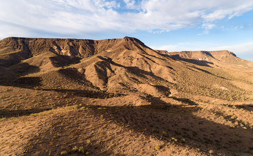
New Water Black Mesa - The early morning sun highlights the cliffs of Black Mesa overlooking Interstate 10 in western Arizona.
New Water Black Mesa – The early morning sun highlights Black Mesa’s cliffs overlooking Interstate 10 in western Arizona.

Last Tuesday, I pointed out the old station’s ruins and told Fred this story—well, an abridged version—as we drove back from our photo-shoot. We went there to photograph this week’s featured image of the Black Mesa in the New Water Wilderness Area. The Ramsey Mine Road approaches the wilderness, and it starts in Brenda. The lava-rock covered mesa cliffs are another of my favorite Interstate 10 landmarks. When I see them on the south side, I know that we’re almost to Quartzite, and the Colorado River is soon after. I’ve admired these formations each time I pass under them, and it’s taken me decades to figure out how to get closer. I called this shot New Water Black Mesa because there are dozens of Black Mesas throughout Arizona, so I have to start including which mesa I’m talking about.

You can see a larger version of New Water Black Mesa on its Web Page by clicking here. Next week we start a new monthly project as well as a new year. Queen Anne and I will still need to keep close to home, so come back next week and see what subject we chose.

Until next time — jw

False Cave Picture of the Week

This week’s featured photo concludes our May adventure to Alamo Lake’s mud cliffs. I have another couple of detail shots that would fit nicely into this grouping, but I’ve run out of weeks this month and we have other places to go. I suppose I could put together a set of six and make up a folio like Santa Lucia Fog, or maybe I’ll go back and shoot enough images to complete a portfolio. I’ll have to think about that—what do you think?

False Cave
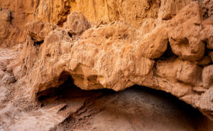
False Cave – This appears to be the opening of a shallow cave, but it’s not that simple.

May’s final image looks like I shot the mouth of a shallow cave with—if you squint and let your imagination go wild—a pair of cherub heads as keystones, and that’s exactly what it looks like when you approach this structure in the field. But there’s something in the photo that gives a clue that this isn’t a cave. It’s the light shining on the floor past the opening. If you crawled into the cave where that light area is, you could stand up—or you could just walk around the pile of mud to the left, and come back down the stream bed. This is actually a low arch that is torso high. If I had a model, her legs would show in the lower opening while her head and shoulders would be visible on top. It would make a unique open shower design—like you would have poolside.

In all honesty, I wasn’t creative enough to come up with that idea. The woman in spring’s photo class, whose images inspired me to visit this place, came here with a group, and one of her friends posed behind the arch. Except he was a guy and he wasn’t naked. When I walked up to this spot, I wasn’t sure it was the same because it’s so well camouflaged. If I do go back for a reshoot, I’ll need to have a model join me. What are the odds of that happening: me—a toothless old geezer—convincing an attractive woman to go with me to this barren wasteland so that we could shoot that picture? Yeah, I didn’t think so either.

You can see a larger version of False Cave on its Web page by clicking here. I hope you enjoy viewing my newest entry and join Queen Anne and I as we present new photos from a different location—this time in Yavapai County.

Until next time — jw

The Spout

This week’s featured image is the third of my Mud Cliffs series that I’ve written about for the last couple of weeks (here’s the original). In the first post, I started at the mouth of the slot canyon and last week, we got to the narrow passageway’s end—or the head. Today, we begin filling the spaces between.

The Spout
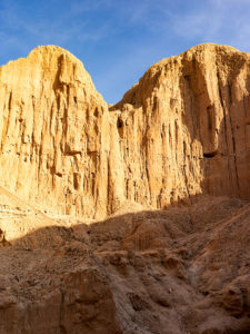
The Spout – With a low sun showing the cliff face structure, the low point turns into a waterfall during stormy weather.

I shot today’s photo, like the first, late in the day on the outbound hike—after the light turned to gold. The low sun adds a warm color to the mud and, in this case, really shows the pillar structure in the sediment. All though, I wouldn’t want to put myself in that kind of danger, I can imagine a temporary waterfall pouring over the spout between the mounds during a summer monsoon. I’ve seen it happen at Lake Powell. We were exploring a similar canyon by boat when an afternoon deluge hit us. It was a Disneyland ride with waterfalls all around. Fortunately, we weren’t hiking and need to worry about escaping a flash flood.

You can see a larger version of The Spout on its Web page by clicking here. I hope you enjoy viewing my newest entry and tag along as we look at the canyon walls for the next couple of weeks.

Until next time — jw

Mud Arch Picture of the Week

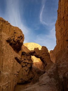
Continuing last week’s adventure to the mud cliffs at Alamo Lake, I took this week’s picture at the other end of the slot canyon. It’s not a very long hike—maybe fifteen minutes if you don’t dawdle—but I was exploring with a camera and stopped to take pictures often along the route. The reward waiting for you at the canyon’s head is this mudstone arch carved by rushing water draining from the surrounding mesa. If you hike a few yards beyond the arc, the canyon ends, and you’re on the mud flats between Date Creek and the Santa Maria River. The water is runoff from the Black Mountains in the north that has carved the canyon from the flats.

Mud Arch
Mud Arch—As a reward for your effort, a mud arch is located at the end of a short hike up the slot canyon.

Since I’m not a geologist, I can’t tell you how old the arch is, but because the surrounding soil quickly erodes and because I slept in a Holiday Inn Express once, I assume that it hasn’t been there for very long—geologically speaking—and it may soon crumble. You’ll notice that the arch’s shape isn’t smooth and rounded like the sandstone arches in Utah, which tells me it hasn’t been polished by blowing wind. That’s another clue to its relatively young age. I won’t be surprised if it disappears in less than a decade.

When I arrived at this scene, the sun was low enough that it didn’t shine onto the canyon walls, but it did add that late afternoon glow to the mound behind it and separated the arch from the background—sort of a spotlight, as it were. With streaky clouds in the sky … what more could a photographer ask for?

You can see a larger version of Mud Arch on its Web page by clicking here. I hope you enjoy viewing my newest entry and tagging along for the other canyon shots I’m revealing this month.

Until next time — jw