The drive between Quartzsite and Yuma on Highway US 95 has two parts. Driving in either direction, it’s thirty miles of gentle uphill grade and then downhill for the other thirty. The mid-point is at Stone Cabin (now an empty building shell), where the Border Patrol checkpoint is.
From Quartzsite, the road is dead straight, and your line of sight is limited only by the whoop-de-woos (wash dips) and the earth’s curvature. The 800-foot climb is barely noticeable, and the road is flanked on the east by the KofA Mountains (named for the King of Arizona mine), and to the west are the Dome Rock Mountains (the dome you see west of downtown Quartzsite).
The south half of the trip has a steeper grade—most of which is in the first mile, where the highway drops off a hill. The scenery changes too. There’s a different mountain range far off to the east—the Castle Dome Mountains, but you’re surrounded by the Yuma Proving Grounds, where the military plays with its new toys. Instead of a pleasant drive through the wilderness, you begin searching for things like the down-looking radar dirigible, a Bradley tank using your car for target practice, or the C-130 that just took off and climbed to 10,000 feet before troopers shove something big out of the back—I sure hope that chute opens.
Whenever Queen Anne and I travel this road, I look for these landmarks to help pass the time. I’d rather have a stimulating conversation about physics with her, but she usually has her head pressed against the headrest, her eyes closed, and her mouth open. She stays that way until one of her snorts wakes her.
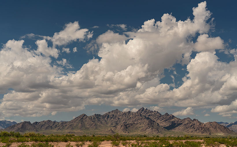
On the drive home, one of the landmarks I look for is a pair of unnamed mountains in the Dome Rock Range. When I pass them, we’re nearing the Quartzsite city limits. The twin peaks look like a pair of dragons sunning themselves on a rock. I’ve often thought I’d like to get their portrait, but no matter how much map scouring I do, I’m unable to find a way to get closer—short of hiking two and a half miles across the open Mohave Desert.
The spiny back of the dragons climbs from the desert to their west-facing heads—where they watch the Colorado River flow south. As with last week’s shot, we always drive by them right after lunch. That’s the absolute worst light in the desert. I keep swearing on a stack of Ansel Adams books that I will shoot them when the light is correct, but it’s yet to happen.
On our last drug run—when last week’s photo was taken—clouds were gathering over the Dome Rock Range, so instead of a uniform blue sky, there was texture over the mountains. After I took the KofA Thunderhead shot, I walked across the highway and pointed my camera at the dragons. This time I twisted the zoom to telephoto and framed the monsoon clouds. The result is this week’s featured image, which I call Dragon Backs.
You can see a larger version of Dragon Backs on its Webpage by clicking here. Next week, I have pictures to show from a different place for show-and-tell. I hope you can take a break from your Christmas shopping and take a look. We’ll see you then.
Till next time
jw
BTW:

Oops, I Did It Again (Britney Spears song written by Richard Thompson). I published another book. This one covers all of the places we visited in and around Flagstaff. As usual, it’s available in two versions. You can see and buy the hardback on Blurb.com—which you won’t do because it’s too expensive—and the free PDF version you can download, view, and print from your computer. There are additional photos in each of the four chapters, so I’m hoping you take a look. You can get to its Web Page by clicking here.

