Sunset Wall Picture of the Week

Alright, class, settle down. Get out a sheet of paper and a pen, then put away your backpacks. Today we’re starting with a pop quiz. There is only one question, and you have 15 minutes to answer with 10,000 words—or more. You must cite your sources. Spelling and punctuation will be graded. Are you ready? Your question is, “What do Memphis, Tennessee, and Kingman, Arizona have in common?”

I have talked before about old trading trails morphing into the well-laid-out highway system that we have today. Most of us don’t care how it happened, and we just drive on them. They think that Eisenhower signed a paper in 1956, and the freeways just popped into existence. I think that’s because people younger than me—and that’s pretty much everybody—didn’t experience the change first hand. Our forebearers built most roads over existing paths, and there are reasons someone blazed those original paths. Mark Knopfler describes this phenomenon well in his 1982 song Telegraph Road from the Dire Straits album Love Over Gold.

There have been trading trails across Northern Arizona since the first Pueblo inhabitants. European settlers didn’t use them much because the New Mexico territory was Spanish. Their roads came up from Mexico to towns like Santa Fe and the Old Pueblo at Tucson. Those roads followed the Rio Grande and Santa Cruz Rivers because there was always reliable water. The rest of the desert was a wasteland. What changed that? It was gold.

In 1848, James Marshall discovered gold at Sutter’s Mill in California. In less than two years, California became a state—that’s instantaneous in government time. They needed to move goods and people to the Golden State—and get the gold back to Washington. But, there were no east-west roads, so they put Captain Lorenzo Sitgreaves in charge of a surveying expedition, and he laid out a railroad route around the 35th Parallel.

Then in 1857, the Fed’s paid Edward (Fitzgerald) Beale to build a wagon road from Ft. Smith, Arkansas, to Los Angeles—again along the 35th Parallel (remember, Tucson was still in Mexico). He built his road in a year using camels because they needed less water and food than oxen and horses. By all accounts, it wasn’t much of a road, but Beale bragged that it was the shortest route by 300 miles and “It is the most level: our wagons only double-teaming once in the entire distance, and that at a short hill . . .” His road became the Santa Fe line in 1880, then Route 66 in 1926, and finally Interstate 40 in 1978.

SR 68 through Union Pass - Arizona State Route 68 (on the right) as it enters Union Pass through the Black Mountain Range.
SR 68 through Union Pass – Arizona State Route 68 (on the right) as it enters Union Pass through the Black Mountain Range.

His wagon road wandered a bit from the 35th as it meandered across the desert, but wagon tracks are visible in places on Google Earth. As vehicles became more efficient, each of the subsequent roads shortened its length. Some silly people hike the old road just for giggles. I’m not that ambitious. However, I do know of a place where you’ll be in Ed’s footsteps. Yep, you guessed it. It’s our Union Pass on SR 68. While Sitgreaves went through Oatman, Beale found a more accessible way to Fort Mohave and his river crossing.

Sunset Wall - Layers of volcanic rock upended vertically in the Black Mountain Range.
Sunset Wall – Layers of volcanic rock upended vertically in the Black Mountain Range.

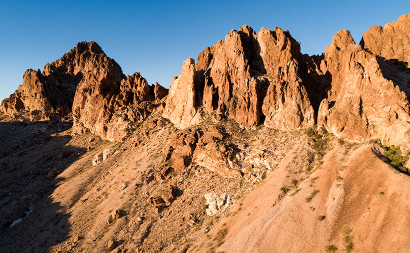
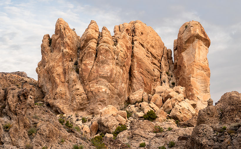
I took this week’s picture on the west side of Union Pass, and it shows layers of lava and ash (tuff) that have been turned horizontal by geological forces. As Don Sprinkle commented in another post; “. . . just like the Grand Tetons.” It was sundown as I took this photo, and that’s why the ordinarily dark rock has a beautiful red glow, and that’s why I called it Sunset Wall.

So, back to your quiz; I’m going to let you grade your papers. What did you answer to: What do Memphis, Tennessee, and Kingman have in common? If you said that they are both along Interstate 40, you get 50%, and if you said that they both have a Beale Street, you get another 50%. I must add that there is a difference too. While Kingman knows who they named their street after, according to the Wikipedia entry for Memphis’ Beale Street, nobody remembers who Edward Beale was, which I find amusing. Maybe it’s forgotten because he was a Union Naval officer.

You can see a larger version of Sunset Wall on its Web Page by clicking here. Please come back next when we begin December’s project and new pictures.

Until next time — jw

Broken Crown Picture of the Week

It takes a lot of space to jam a four-lane freeway through a mountain pass. If you have a horse-drawn wagon, you can squeeze through some tight spots, but with a Peterbilt 579—not so much. You have a couple of options to get that extra width—cut back the mountains or raise the road over them. A more practical approach is to do a little of each. Cut into the hills some and use that fill to raise the road—like how we build today’s modern highways.

The reason I bothered with this engineering exercise is that there are segments of the old Union Pass two-lane road that you can still explore, but they’re maybe 50 feet below the current grade. The more extensive section is on the west side of the Black Mountains crest, which we’ll talk about next week. On the east side, less than a mile of Old SR 68 remains. It’s behind an unlocked ADOT gate meant to keep livestock off of the highway, so be sure to close it after you. The road-gate is the public access to the old Richardson Homestead—a one-family ghost town.

The Richardsons were a family of five who settled the homestead in 1897. When they claimed the 160 acres, it had spring water, enough flat land for an orchard, vegetable garden, and a horse barn left behind by Union Troops stationed there to protect travelers from hostile Indian tribes. In summer, they made the journey from Los Angeles in a covered wagon pulled by a pair of horses.

They moved after John’s doctor told him to “go live in the desert.” I didn’t find a reference to John’s ailments, but that was a standard remedy for tuberculosis back then. The clear desert air undoubtedly helped him because John and his wife, Victoria, built a two-story home, root-cellar, planted trees, and raised livestock using only their sweat and simple hand tools. After establishing their home, Mohave County paid them a monthly allowance to maintain—what was then known as Beal’s Wagon Road—three miles in each direction. For thirty-eight years, they welcomed weary travelers with fresh fruits, preserves, vegetables, cold water, and a place to spend a night.

Victoria succumbed to cancer in 1935—four years after their fiftieth wedding anniversary. John followed five years later. Today they rest side by side in Kingman’s Mountain View Cemetery on Stockton Hill Road.

If you can call middle-aged adults kids, they managed the ranch and changed to keep up with the times. They added guest cabins, a small store, and a gas station. The family enterprise lasted until 1984. We, like our parents before us, didn’t have time to stop at some old place along the road. We had places to go. Shortly after that, the last of the family gave up the land, and the BLM took back ownership.

I remember the Richardson Homestead as a shady oasis on the drive between Kingman and Bullhead City. We would do the long climb from the river, and soon after cresting the hill, tall trees shaded the old road. The collection of rock-wall buildings and weathered metal roofs were always a  blur as we sped past. I vividly recall one early morning return trip. I remember the time because of the golden light. After we passed the old gas station, we saw real-live cowboys on horses driving cattle down the hill on the roadside. My companion and I laughed out loud because we had never seen working cowboys in Arizona—just the plastic ones that hang out in Scottsdale.

Broken Crown - A crown of tuff rests on a layer of basalt in Union Pass.
Broken Crown – A crown of tuff rests on a layer of basalt in Union Pass.

When I pulled over and stopped Archie to shoot this week’s picture, it was beside the homestead. Before I ran across four lanes of traffic (it was very early sun-up and no one was on the road yet), I looked over the guardrail at the remaining ruins and blew them off. I wasn’t out house hunting. Instead, I opted to focus on rocks (pun intended). This large outcrop of tuff on top of a basalt layer was just the ticket. I call this image, Broken Crown because of the fresh rock-fall and truck-sized boulders on the right. But, now that I know about the Richardson family, I want to return soon and wander among the remaining ruins with my camera.

You can see a larger version of Broken Crown on its Web Page by clicking here. Please come back next for our final image in this series and the story that goes with it.

Until next time — jw

Potato Patch Picture of the Week

A couple of weeks ago, I talked about my struggle to climb a half-mile to an overlook on Hualapai Mountain Park’s Potato Patch Trail. Remember? Some hikers felt sorry for me and offered water while others were impressed that I was old, but still on my feet. Anyway, I’ll bet you’re wondering if there’s a picture from there. The answer is yes, and here it is.

Potato Patch
What appears to be the mountain top conceals the real summit – Hayden Peak which is another half mile away and three-hundred feet higher than these rocks.

This week’s shot is from the rocky perch looking up at a false peak. It’s one of those illusions that happen on a trail where you say, “I’m almost there.” So, you keep going, but when you get there, you find that Mother Nature has moved the finish line. The image shows rocky outcrops that are an unnamed high point on the mountain, but the real summit is Hayden Peak, which these rocks hide and the actual summit is another three hundred feet higher. Between this false summit and Hayden Peak is something called The Potato Patch, which will remain a mystery until I return or someone enlightens me, so that is the story behind this weeks image title and I’m sticking to it. I’ll bet you thought my imagination had run wild again, or that I suffered from altitude sickness.

The view facing east at the overlook was disappointing. From the ledge, you could look across Sawmill Canyon and see Dean Peak and all of its communication towers. The little village below was obscured by pine and scrub oak trees. There was also a small window between the trees where you could see Snow Peak twenty-eight miles away in the Aquarius Range on the other side of the Big Sandy Valley (U.S. 93). I didn’t even try to get that shot because it was too much of a reach for my camera lens.

You can see a larger version Potato Patch on its Web Page by clicking here. Be sure to come back next week when we’ll show one last photograph from the top of the Hualapai Mountains.

Until next time — jw

Four Ponderosa Picture of the Week

When an Arizonan talks about a pine tree, the red barked ponderosa is most likely what they’re referencing. It’s the common pine tree in Arizona. We have so many of them that our grove grows like a slash across the state’s middle, like a belt, and they continue east into New Mexico. It’s the world’s longest contiguous ponderosa forest in the U.S. Sadly, some of our brightest citizens try to burn them all down each fire season.

It’s a happy tree for me because it means that I’m in the high country when they’re around. Most likely, I’ve traveled to escape the desert heat and spend some time in the shade of the tall pines napping with a bit of fishing line tied around my toe. I have a fond memory of getting up early on a fall morning to drive up to Hawley Lake, and as the sun came up, we were on the Rim Road. The morning sunlight flickered between the tall trees, and I felt like I was driving through the Black Forest in Germany. Although I’ve driven that road hundreds of times since then, I’ve never had the same feeling.

Four Ponderosa
Four Ponderosa – Growing in a grouping that reminded me of a four-poster bed. Maybe I thought that after my long hike and I was tired (and don’t forget, tired).

During my visit to the Hualapai Range outside of Kingman, I was surprised to see ponderosa growing. In the Desert Southwest, they only grow at higher elevations. On the road, I rely on the trees to estimate my height. First, come the pinion pine at around 5,500’, then the ponderosa starts at 6,500’, and then the aspen show up at over 7,500’. The mountain island on top of the Hualapai’s probably is most likely the western edge of our grove. Only the Black Mountains are west of here, and they’re not high enough to support the big trees.

I walked by the ponderosa’s in this weeks image on my way back to Archie after a hike up the mountain. My legs were already sore, and this four-tree grouping reminded me of a four-poster bed. The spacing between them was ideal for hanging a hammock. It’s a good thing I don’t carry one because I would have spent the night, or even worse, I would have rolled over and fallen out onto the ground. That would be just my luck.

I call this week’s image Four Ponderosa, and you can see a larger version of it on its Web Page by clicking here. Be sure to come back next week when we show another photograph from the Hualapai Mountains.

Until next time — jw

Bumble Snake Picture of the Week

This week’s image is the last in our Route 66 Car Show series, and coincidentally, it’s also a significant motorsports TV holiday. Much like how fans spend Thanksgiving and New Years vegging out on the couch watching football—today is wall to wall car races.

Bumble Snake
Bumble Snake – An unidentified yellow car that was on display at the Route 66 car show in Kingman, Arizona.

The day starts in Monaco and the Formula One Grand Prix. It’s not the fastest F1 race, but all of the glitz and glamour surrounding it makes it the year’s biggest spectacle. Although I love watching the cars parade through the streets, I’d die to attend a progressive dinner that stopped for new courses on each of the yachts moored in the harbor. Next on the schedule is the Indianapolis 500. It’s the World’s Greatest Race according to the promoters. I suppose it is, much in the same way that McDonald’s is the World’s Greatest Hamburger. Then after a couple of ribs off the bar-b, the evening show is the Coca-Cola 600 at Charlotte.  Although it’s not NASCAR’s premier race, it is the longest of their season as it transitions from day to night.

TV races are the bastard red-head step child of sports, and die-hard fans always had to work to see them. When I was a teenager, we bought tickets to see the ‘500 on closed circuit at the Grauman’s Chinese theatre. We’d pay 10 or 15 bucks to see a low-res TV image blown up to movie screen size. You couldn’t tell one car from another, so what we experienced was paying money to listen to the radio broadcast while watching a bad Nintendo game. At least it was live. ABC sometimes showed Monaco a week later on its Wild World of Sports, but it was a heavily edited highlight reel that shared airtime with the Bocce Ball finals. As for Charlotte, nobody showed hillbilly racing on TV, except maybe Daytona. Racing wasn’t crucial to broadcasters until they found out that motorsports draw more viewers than any other sport except for horse racing.

Watching the shows is so much better now. First, it’s live on the network channels with some timing overlaps. Having a TIVO takes care of time conflicts. More importantly, by recording them, you can turn 16-18 day of binging into a 6 hour evening by zipping through the commercials. If I start around 2:00 pm, I usually catch up to the live broadcast with 20 laps to go.

In all seriousness, Memorial Day is really about remembering the men and women that fought and died to defend our freedom. We can do that on Monday, which is Memorial Day proper. But, it has to be done in the morning, because we need to get home in time to catch the sportscar race at Lime Rock.

This week’s featured image—oh yeah. It was one of the cars on display at the Route 66 car show in Kingman. It didn’t have any name badges on it, so I couldn’t tell who manufactured it. It looks British, so maybe it’s an MGB. If you look closely on the front, the owner didn’t bother to wipe off the squashed insects it collected on the drive from Seligman, so maybe it’s a bug-eyed Sprite. I called this image Bumble Snake because of the bright paint scheme. You can see a larger version of Bumble Snake on its Web Page by clicking here. Next week begins a new month, and we’ll show off some images from another Arizona place.

Until next time — jw