Prescott Basin Picture of the Week

There’s a growing trend in the comedy routines that Queen Anne and I watch on YouTube’s Dry Bar channel. The bits poke fun at young people for not knowing about obsolete things my generation regularly used. I’m not sure if the joke is at the youth’s expense or if it’s simply us old farts complaining about change again.

To give you an example, one performer asked a teen in the audience to explain the relationship between a pencil and a cassette tape (the kid didn’t know what the tape was). Another was about the phone books we used to get each year. The fact that we had to look numbers up on our own was mind-boggling enough, but they couldn’t comprehend that the books were primarily used at grandma’s house as a booster seat. Finally, hold up a 10’ curly phone cord and ask a young person why it existed.

I uncovered another lost phone tradition this week after talking to a particularly annoying salesman. It’s known as the old 40mph-hangup. I learned it from my dad back in the age of unenlightenment. It has Zen-like qualities and resembles a marshal-arts move, but it more closely mimics the grace of a baseball pitch. I’ll try my best to describe it. After you’ve had your fill with the person at the other end of the line, you scream a final taunt—after all, you must have the last word—then as you lift your left leg, you begin to swing your right arm in a full roundhouse motion and slam the handset onto the cradle. It should bounce at least once. I saw my father shatter an old black Bakelite phone we were renting from Ma Bell. Although this hang-up never accomplished anything productive, it always put a satisfying exclamation point on your lunacy.

With remote handsets these days, they took away that small joy of life. No matter how hard you mash the End button, it’s silent. Your adversary doesn’t know if you hung up or the phone dropped the connection. I don’t own a smartphone, but vigorously swiping at the screen can’t be any better. Maybe someone could write an app that plays a recording of a loud car crash before disconnecting. That would come close. Kids don’t know what they’re missing.

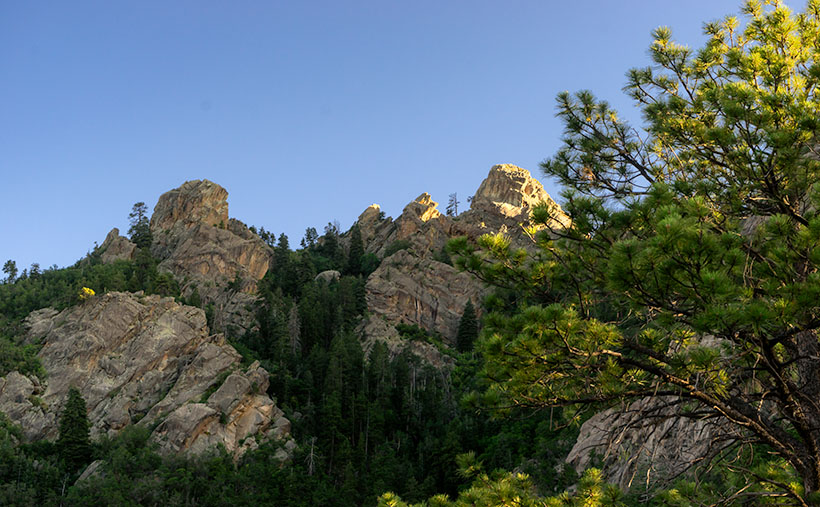
Now we have to find another channel to drain all that excess adrenalin. I could have run up and down the Little Granite Mountain Trail a couple of times with that pent-up anger. I wouldn’t have even broken into a sweat by the time I reached upper flats. Instead, I had to stop constantly until the pounding in my ears subsided.

Prescott Basin - You can see miles in any direction from the flats on the Little Granite Mountain Trail, like this view of Prescott to the east.
Prescott Basin – You can see miles in any direction from the flats on the Little Granite Mountain Trail, like this view of Prescott to the east.

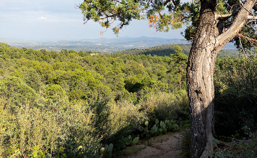
It was at one of those rest stops that I got this week’s featured image. Close to the trail’s top, it begins to flatten, and you can finally see above the trees. After I passed this Alligator Juniper, I stopped for a rest. Here, I could see Prescott in the distance below, so I couldn’t resist snapping a photo. The view was hazy from the humidity, so I’m sure it would be spectacular on a clear winter afternoon. I call this photo Prescott Basin. I hope you enjoy seeing it.

You can see a larger version of Prescott Basin on its Web Page by clicking here. Next week, we’ll walk around and take in more views from the top of the trail, so I hope to see you then.

Until next time — jw

Potato Patch Picture of the Week

A couple of weeks ago, I talked about my struggle to climb a half-mile to an overlook on Hualapai Mountain Park’s Potato Patch Trail. Remember? Some hikers felt sorry for me and offered water while others were impressed that I was old, but still on my feet. Anyway, I’ll bet you’re wondering if there’s a picture from there. The answer is yes, and here it is.

Potato Patch
What appears to be the mountain top conceals the real summit – Hayden Peak which is another half mile away and three-hundred feet higher than these rocks.

This week’s shot is from the rocky perch looking up at a false peak. It’s one of those illusions that happen on a trail where you say, “I’m almost there.” So, you keep going, but when you get there, you find that Mother Nature has moved the finish line. The image shows rocky outcrops that are an unnamed high point on the mountain, but the real summit is Hayden Peak, which these rocks hide and the actual summit is another three hundred feet higher. Between this false summit and Hayden Peak is something called The Potato Patch, which will remain a mystery until I return or someone enlightens me, so that is the story behind this weeks image title and I’m sticking to it. I’ll bet you thought my imagination had run wild again, or that I suffered from altitude sickness.

The view facing east at the overlook was disappointing. From the ledge, you could look across Sawmill Canyon and see Dean Peak and all of its communication towers. The little village below was obscured by pine and scrub oak trees. There was also a small window between the trees where you could see Snow Peak twenty-eight miles away in the Aquarius Range on the other side of the Big Sandy Valley (U.S. 93). I didn’t even try to get that shot because it was too much of a reach for my camera lens.

You can see a larger version Potato Patch on its Web Page by clicking here. Be sure to come back next week when we’ll show one last photograph from the top of the Hualapai Mountains.

Until next time — jw

Lava Tube and Brittlebush Picture of the Week

Everywhere I look, the desert is yellow, and it’s as thick as a jungle out there. When Queen Anne and I run into town, the train tracks—only a block from the road—are hidden behind the dense foliage. I supposed this was predictable with the good rains we had this winter. We had a good crop of poppies this month along with purple lupine and orange mallow lining the highways.

Several plants give to the yellow with the first to bloom is the Brittlebush. Their soft yellow flowers look like small pale yellow daisies on stems rising from sage-green leaves. Unlike the poppies, their color isn’t vibrant, but they’re so pervasive that they’ll turn mountainsides yellow. They thrive in disturbed soil, like the highway shoulders.

Creosote bush adds a second note of yellow. The lowly creosote is like the lawn of the desert, except it grows 4-6 feet high. A couple of weeks ago, the field across from the park was Kelly green. The bush’s flower is small—almost like buds, and now that they’ve popped, the green has a golden tint.

The yellow crescendo comes when the Palo Verde bloom. Last week, Her Majesty and I ran down to our dentist at the border, and along the way, the trees were already blooming in the low-lands. The bloom moves through the desert like an opening curtain into the highlands. Today I see the trees in our park are beginning to show the tiny flowers. At their peak, the Palo Verde dot the mountainsides with yellow splotches. It’s then you realize that they’re growing everywhere. There’s a color symphony, and quail provide the background music with calls as they stake out their territory. It’s the best time to live in the Sonoran Desert.

Lava Tube and Brittlebush
Lava Tube and Brittlebush – Three of the flowering plants grow among the rocks below a lava tube.

When Fred and I were out taking photos in Black Canyon a couple of weeks ago, I saw lots of brittlebush growing in the lava rock cracks. Their soft yellow popped against the dark, almost black canyon walls. Since they screamed, “Spring,” I wanted to capture the contrast. Out of the several shots that I took, I liked this week’s image best.

In the shot that I call Lava Tube and Brittlebush, three plants were growing below a gaping void in the rocks. I believe it’s a tunnel that formed when the molten magma lost pressure then receded. It’s just like when you were little, and your older brother tortured you by pinning you to the floor then drooled over your face but sucked the spit back at the last moment. The threat was always worse than the spit. Oh! By the way, on your first desert visit, inevitably someone will tell you, “Don’t sick your hand into any place you can’t see.” The lava tube is an excellent example of what they mean. I tried to get Fred to see if he could find any rattlers in there, but he refused. He was no fun at all.

Oh, if you’re wondering how brittlebush got the name, here’s an example of how they look after a couple of weeks without water.

You can see a larger version of Lava Tube and Brittle Bush on its Web Page by clicking here. I hope you enjoy viewing this week’s post and next week; we’ll show another featured image from a different Arizona site.

Until next time — jw

Vortex Picture of the Week

Have you ever been to a place, but you didn’t know you were there until you went away? I know that sounds like a Yogi Berra-ism, but it will make perfect sense once I explain. Most of the time when I’m out shooting, I have to come back to the office and scour maps to name the landmarks that are in my pictures—and you thought I was a human geography book. That’s the story behind this week’s featured image that I call Vortex.

Vortex
Vortex-I was able to compose two photographs standing on the Boynton Pass Overlook. I found out later that it’s also the location of one of the four Sedona vortexes.

For Sedona month, I wanted to get images of the red rocks that aren’t on every calendar that you’ve owned, so I scouted and explored a couple of trails that were off the beaten path. One of them was the Boynton Pass Overlook Trail, and I took the Climbers photo featured three weeks ago from the same place. Back at the office, I searched Google Maps to see if the pinnacle they were scaling had a name. It didn’t (Wrong. According to the site in the following link, its name is Kachina Woman – jw), but—according to the map—I was standing on (or near) the Boynton Pass Vortex. When it comes to those kinds of metaphysical things, I must admit that I’m a skeptic, so I wasn’t searching for a vortex. I was after the view. It’s interesting that there isn’t a marker to show it’s there and I didn’t come away enlightened. I did, however, get two photos from one spot, so maybe …

This smaller turret and the much taller tower as seen in Climbers flank each end of the overlook saddle. Since they’re on opposite ends, if you look at one, you have to turn around to see the other. I liked the shape of this little guy—it kind of looks like an inverted tornado. I don’t know what a vortex looks like, so maybe this is one.

Another thing that appeals to me is the plants. Within the frame, are all the varietals that make up the Sedona chaparral: juniper, sage, prickly pear, agave, and some others that I can’t identify by name. I’d like to think that this shot is a miniature Sedona model—a stack of red sandstone and the plants thriving there. If I had a stag deer majestically posing in the photo, it would have been perfect—or maybe have it spinning through the air like the cows in the movie Twister.

You can see a larger version of Vortex on its Web Page by clicking here. I hope you enjoy viewing this week’s post and come back next week when we’ll start another month in a new site.

Until next time — jw

Well Turned Ankle Utah Photo Shoot

The suffering that I must go through to please you people. As I sit here on the couch and looking at my right leg propped up by a pillow, I see that my ankle is thicker than my calf muscle. I had a friend in high school—a girl—who’s legs looked like this. She always lamented that they installed her legs upside-down. That’s how my right leg looks now.

I managed to injure my ankle by twisting it on the hike back from Coyote Gulch in Utah. My pain worse because I didn’t get the shot I wanted. I was this … close. I allowed four hours to trek out, get a shot, and then hike back before the sun went down. The two-mile trail alternated between fine red-powder sand and slick rock which I preferred because I made better time while I walked it. As I neared the canyon, I was concerned because I couldn’t see it. It’s the same as Horseshoe Bend on the Colorado River, so you have to walk to the edge to look into the chasm. The photo shows just how close I got and when I took it, I was not on the trail. What you can’t see in the picture is that beyond the cairn the trail descends like walking down a ball. To get back up, I would have needed to crawl on my hands and knees. Incidentally, that’s a very narrow ridge to be carrying a camera pack and tripod, so yes, I was a-scared. (BTW—here’s a link to what’s down there. It’s copyrighted so I can’t post it, but I can send you for a look.)

The Top of Hamblin Arch
The Top of Hamblin Arch-This is how close I got to my subject. You’re looking at the top of Hamblin Arch, like looking at an elephant’s trunk from its brow. The cairn on the ridge marks the real trail. Behind the cairn, you can make out the arch underside.

I twisted my ankle a third of the way back, and it’s the third time I’ve injured the same ankle. Each time I was carrying a load and my foot rolled-over 90º so that my entire weight was on that pointy ankle bone. Like the other times, I didn’t have a choice but to keep walking and the two-mile trail turned into four miles, then six. I became concerned that I wouldn’t be able to get back to the truck before dark. I began having thoughts about my demise. I wondered if I’d have to eat the dead, except I was alone. I questioned when my camera and tripod would become so much of a burden that I’d discard them along the trail. In case you’re worried, I didn’t die. I got to the truck at sunset and spent the night alone under the stars. I drove back to town the next morning and called my caring wife to tell her I had to come home early—she would need time to get rid of her boyfriends—the Chippendale Dancers.

I think that after the first injury, my ankle is susceptible to re-injury. I wear good hiking boots, and because of their high tops, they have more support. With all the walking, hiking, and biking I’ve done in the past couple of years, I thought my ankle would be stronger. If I want to get back out there and get those out-of-the-way shots, I’m going to have to do strength training exercises and tape my foot up before a hike.

Instead—I’m buying a drone. The one I’ve settled on has a four-kilometer range, and I could fly it out there and get my shots from the parking lot. I’ve pondered how to get more height in my photos anyway, and a drone is a perfect answer. A drone is a medical necessity—no less than an Iron Lung. The challenge I have is that I want a quality camera equal to my current gear. That camera is $21K, and lenses start at $10K. A drone stout enough to fly it is another $7K, and the controller is another couple of grand. Sure, fifty-thousand dollars sounds like a lot of money, but that’s the cost of an emergency room visit and a couple of nights in intensive care. I wonder if my health insurance will cover it if my doctor writes a prescription.

Until next time—jw