Dos Cabezas Mountains Picture of the Week

Dos Cabezas Mountains - The 'two head' mountain range is a prominent landmark in southeast Arizona.
Dos Cabezas Mountains – The ‘two head’ mountain range is a prominent landmark in southeast Arizona.

Memorial Day has snuck up on us already. The unofficial summer season begins today. Back east, our friends and family have opened swimming pools, drug their Webber grills out of the garage, and finally put on shorts—with white belts and black socks. Meanwhile, here in the desert, we’re beginning to think of clever ways to stay cool for the next three months. This year, Queen Anne and I have come up with some new places to visit, but we have to stop buying food to have gas money.

Before worrying about surviving June and its 110º temperatures, we need to finish May. So, let’s return to our Cochise County Road 186 project, jump into the car, and find one last shot. Then we can drive into Willcox, where I know of a decent Mexican restaurant for dinner.

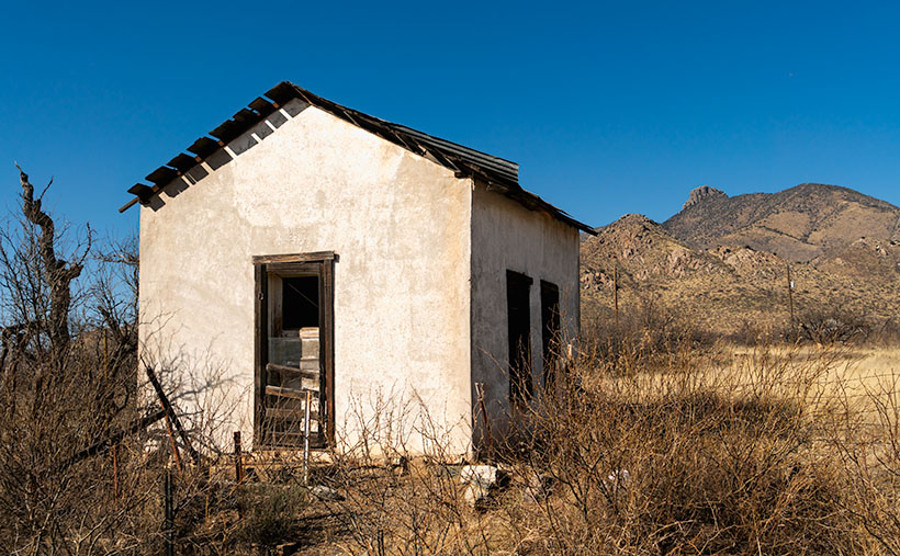
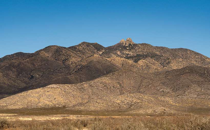
With the ghost town of Dos Cabezas in the rearview mirror, the county road begins to drop from the foothills into the Sulphur Springs Valley. All of the time, the ‘two-headed’ mountain range looms in the east. The south head blocks its northern twin brother from town, so we will drive several miles until both outcrops are visible. That turned out to be a spot where I could hike past a ranch gate and get this week’s picture.

At first glance, the range resembles a two-headed giant with 15-mile broad shoulders that I’ve seen in cartoons. The twin heads are weathered granite, and the highest one (the south) is 8,354 feet in elevation. That’s not as impressive as it sounds because the valley floor has an average height of 4,000 feet above sea level, but Interstate 10 still detours several miles north of the left shoulder to get around the range. A dirt road on the range’s south side divides the Dos Cabezas and Chiricahua ranges. That road goes to the historic site of Fort Bowie through the ominous Apache Pass. Since that road served as the main trail from New Mexico into Southern Arizona, the Cavalry built the old fort to quell the frequent ambushes by renegade Apaches.

I call this photo Dos Cabezas Mountains because I have a vivid imagination. The sky looked clear and blue, but a few clouds to the south cast shadows over the range. Fortunately, that saved this image from being flat and lifeless. The dark-green patches near the mountain top are tall ponderosa pines. In this picture, the land traverses three climate zones, and that’s an example of why the patches of Coronado National Forest are called Sky Islands. Finally, the San Simon Valley and New Mexico are on the other side of these mountains.

You can see a larger version of Dos Cabezas Mountain on its Web Page by clicking here. Next week, we begin searching for summer refuges, but before we load the Jeep, I will return to a previous location as promised earlier this year. Be sure to come back and see what I’m talking about.

Till Next Time
jw

White House Picture of the Week

White House - An abandoned dwelling of some sort in the ghost town of Dos Cabezas.
White House – An abandoned dwelling of some sort in the ghost town of Dos Cabezas.

Ghost towns are a big business in Arizona. That’s good because we have our fair share, and a few of them attract many tourists. They’re our Disneyland. As soon as your relatives hit the tarmac and demand to see the state, the first suggestion out of your mouth is, “Let’s go to Jerome (Bisbee-Oatman-Tombstone-etc.).” You’d think that, by definition, ghost towns are abandoned places—they had their heyday long ago, but the residents left when things went south. But, that’s not necessarily true. The population count in some of our mining towns rivals the numbers they had in their prime. Our hometown of Congress is an example. People move here to get away from Phoenix’s smog and traffic—or the Minnesota snow—and they’re all on the road and in my way.

I’ve concluded that somebody loves it and wants to live there no matter how remote one of these places is. Take the town I introduced last week—Dos Cabezas. Among the derelict buildings, there are two surviving businesses. One is an art studio/gallery (Dos Cabezas Art Gallery), and the other is a bed and breakfast (Dos Cabezas Retreat Bed and Breakfast). At least those are the two places that advertise their presence. There are several cattle ranches in the area, and there is an emerging wine presence, but not within the town limits.

I don’t know anything about the gallery, but enjoying a glass of local wine while staring at the stars on the B&B patio would be a treat. Since it’s closer to the Chiricahua National Monument, it’s an alternative to the chain hotels or downtown dives in Willcox. The two guest rooms are in an adobe walled casita, and as the name implies, the hosts include breakfast. A drawback for Queen Anne and I would be dinners. The nearest restaurants are 15 miles away in Willcox or Douglas, over an hour’s drive south. If you’re a person that needs bright lights and noise to sleep, the retreat wouldn’t be your cup of tea—the nights in the middle of Sulphur Springs Valley are exceptionally dark and silent.

As you can tell from this week’s picture, the little ghost town is at the foot of the Dos Cabezas Mountains. It’s near the range’s southern reach, so you can only see the south head (Cabeza). There’s a road and trails that will get you to the top, where I imagine the view of the valley and Willcox Playa is spectacular. You need permission to cross a locked gate, and the top is steep, so why bother?

In this image that I call White House, I assume it was a dwelling. It’s a palace compared to some of the miner’s shacks I’ve seen. Unlike the other buildings in Dos Cabezas, this one is a fixer-upper. You have affordable housing with a bit of paint, a few shingles, and a yard clean-up. But there’s probably a community historical committee that needs appeasement, so you can’t paint it purple.

Unlike last week’s photo, the white stucco pops against the brown mountain and clear blue sky, and I like that. There’s plenty of side yard where I visualize Queen Anne hanging laundry on a solar drier. Then, this would be a picture that Norman Rockwell or Andrew Wyeth would envy. Where’s the Saturday Evening Post when you need them?

You can see a larger version of White House on its Web Page by clicking here. Next week, we continue down County Highway 186 in search of an image worthy of another car stop. Please join us.

Till Next Time
jw

Adobe Ruin Picture of the Week

Adobe Ruins - In the ghost town of Dos Cabezas, most of the remaining buildings are severely decayed.
Adobe Ruins – In the ghost town of Dos Cabezas, most of the remaining buildings are in a severe state of decay.

Roughly midway between Willcox and the Chiricahua National Monument, the county highway’s speed limit drops to 45 mph. At first, there’s no clue about the slowdown until a small sign announces that you’re entering the town of Dos Cabezas. Only three of its dozen or so buildings are worthy of occupancy. The rest are in various states of decay. It’s only a city block long, and you soon return to an empty country road, where you can reset the cruise control.

After driving through Dos Cabezas three times, I insisted on stopping on our fourth pass. As regular readers know, I’m a sucker for historic buildings, whether they’re restored or about to be blown down by the wind. I’m glad that I did, and this week’s featured shot is one of several that I captured during that afternoon.

As with most Arizona ghost towns, Dos Cabezas’s history is a flash of glory followed by a long decay period. The town is located at the southeastern reach of the mountain range, which shares the same name. When word came out that prospectors discovered gold and silver on the mountain, miners swooped in like hungry vultures to feed on a carcass. The Feds opened a Post Office in 1878, which served a population of 300 that eventually swelled to over 4000. They found little gold in the Elma mine, but there were some copper deposits. Investment capital dried up when investors discovered that the mine was a scam and part of stock fraud. People left to find work elsewhere. As the town dwindled, the Post Office finally closed its branch in 1960. I guess that you could count today’s Dos Cabezas citizens on one of your hands.

In this picture that I call Adobe Ruin, you see the remains of a large building constructed using adobe bricks and stucco. The town once had a hotel, and these sections may be all that’s left of it. Adobe was a common building material throughout the old southwest because it was simple to make. All you need is to combine mud and straw and let it dry in the sun. The thick bricks provide plenty of protection from the desert heat and cold winters, but they quickly erode once water enters them.

I took several variations of the building, but I favored this one because I liked the mud stains streaking down the wall, and I liked the wall’s placement before the background’s two-headed mountain. The desert willow and hackberry show how soon nature reclaims her own. Ashes to ashes, as it were.

You can see a larger version of Adobe Ruin on its Web Page by clicking here. Next week, we’ll walk down the street to look at another of the Dos Cabezas ruins. Come back then and have a look.

Till Next Time
jw

Schwertner House Picture of the Week

Schwertner House - Built as an overnight barracks for Army officers during the Apache Wars, the Schwertner family bought and lived in the house until 1980.
Schwertner House – Built as an overnight barracks for Army officers during the Apache Wars, the Schwertner family bought and lived in the house until 1980.

In 1880, when Southern Pacific established a whistle-stop in Willcox, there was peace everywhere in the country except in Cochise County. Here the Army was busy battling Cochise and Geronimo in the Chiricahuas. Stupid decisions made by Army officers prolonged the Apache Wars, but that’s another day’s story.

The U.S. Army operated from several forts in the southeast corner of the Arizona Territory, and the newly built railroad was an efficient way to get officers into Arizona. So, the Army immediately paid to have a boarding house built within walking distance of the Willcox train station. The green officers had a place to stay until troops escorted them to Fort Bowie, Fort Grant, or Fort Thomas.

After hostilities ended, Joseph Schwertner bought the barracks for his family’s home. Joe was a well-off Schley saloon owner, one of several that lined Railroad Avenue at the turn of the century. After Joe died in 1929, his heirs continued to live in the house until 1980, when they gifted it to the local historical society. Today, the pretty little yellow house with green shutters is one of several buildings in Willcox on the National Registry list and is open for tours.

In this week’s picture, I shot the historic home at dawn just after I got my first cup of coffee and my eyes finally opened. I called the shot Schwertner House—its proper name. In addition to the lovely morning light on its yellow front and new metal roof, I like the picket fence (I’m a sucker for picket fences because they’re rare in Arizona). The dark green shutters should be next on the TLC list.

What if you’re not into history and old buildings? What else is in Willcox that makes it worth a visit? A mile or so east of the railroad crossing is the town’s golf course. It’s not fancy, and it will never be on the PGA tour, but that’s not important to most golfers. I’ve never been good at stick-and-ball sports, so I’m not keen on golf. However, on the road and just past the course is something that I do find exciting.

Willcox Playa Sandhills - Sandhill Cranes stop at the Wilcox Playa on their way to Canada.
Willcox Playa Sandhills – Sandhill Cranes, stop at the Wilcox Playa to rest and feed on their way to Canada.

We started our Willcox story a couple of weeks ago by explaining why Southern Pacific picked this spot for a stop. The railroad located the town along the northeast part of the Willcox Playa. Usually a dry lakebed, there is enough seasonal water to fill the low spots. Because these shallow pools are dependable year after year, migrating waterfowl stop for food and rest.

The most notable flock of birds is the Sandhill Cranes. The large stilt-legged gray birds are in the ponds late winter until the weather warms enough to continue to Canada. The playa is the best place to watch the red-faced birds this side of New Mexico’s Bosque del Apache preserve.

Since the access road encircles the ponds, you can watch the cranes from your car. In freezing mornings, the birds cluster in tight groups, communicating with trills, clucking, and squawks. Before they take to the air, their cacophony gets louder and the pace quicker. Then a half dozen take a couple of steps and flap their long broad wings rising gracefully above the pond. In winter, the air in Sulfur Springs Valley has temperature inversions, so the birds fly up to where the air is warmer and soar over town. The locals proudly call the phenomena Wings over Willcox, or WOW.

You can see a larger version of Schwertner House on its Web Page by clicking here. Next week, I have a final shot of historical Willcox, so come back and see what we’ve dug up.

Until next time — jw

Mack’s Bar Picture of the Week

Mack's Bar - Something that its patrons may never see is the early morning sun shining on Mack's Bar in Willcox, Arizona.
Mack’s Bar – Something that its patrons may never see is the early morning sun shining on Mack’s Bar in Willcox, Arizona.

“Gee, had I only known …” I don’t know about you, but I’ve uttered that phrase a lot. I shouldn’t be surprised because my mom always told me that I “was a day late and a dollar short.” And, I always thought she called me sun because I was so bright.

This time I whispered the idiom to myself after getting back from our Cochise County trip. As I always do, I began looking for stories that complement my pictures. I found a great story about another Earp shooting. Not Wyatt. That would have been too good. This incident involved the shooting death of Warren Earp—Wyatt’s youngest brother—at 1:30 am July 6th, 1900, in the Headquarters Saloon.

If you’re not familiar with the controversial Earp brothers (where have you been), they were supposedly the good guys at the OK Corral shootout in 1881—even though they wore the black hats and black dusters. I don’t want to dwell on the Tombstone incident, but the short version is that Wyatt, two of his brothers Virgil and Morgan, and their friend—Doc Holiday went to the corral to disarm four Clanton Gang cowboys. The confrontation erupted in a 30-second gunfight where the Earp’s killed Tom and Frank McLaury and Billy Clanton while Ike Clanton managed to run away. (In this video, Bob Boze Bell—former DJ, artist, and publisher of True West magazine—explains the shootout’s story better. It’s longish but interesting.)

Warren wasn’t in Tombstone at that time because he was too young and lived with his parents in California, but he later got entangled in the subsequent vendetta that lasted another year. By 1900, Warren had settled in Willcox, a mountain range east of Tombstone. He worked as a stage driver for the mail and a Sierra Bonita Ranch hand. It was at the ranch where he and Johnny Boyett became close.

On the fateful night, Warren and Johnny got into a shouting match in the saloon on the northeast corner of Maley Street and Railroad Avenue (diagonally across the street from last week’s train station). As their argument heated, they threatened to kill one another, although neither was armed. Short-tempered Warren and Boyett left the bar separately. Earp wanted to cool off, and Johnny went to get a gun. When Warren returned through the back door, Boyett shot at him four times. He seemingly missed on purpose. Earp taunted the ranch foreman and opened his duster to prove he didn’t have a gun. “Don’t come an inch closer,” Johnny shouted, but Warren continued. Johnny fired another round sending a bullet through Earp’s heart. Warren fell foreword, dead onto the floor. Then things got weird.

Between the 1:00 am shooting, and sunrise, Earp’s body was dragged to the cemetery and buried in an unmarked grave. Meanwhile, the Sheriff arrested Johnny. Then he got the local judge out of bed. They held a trial, where the witnesses testified. Finally, the judge determined the shooting was justified and freed Johnny Boyett. The incident was closed and sealed forever.

There is a tantalizing clue, however. In the 1930s, a reporter interviewed a woman living in Prescott’s Pioneer Home. Her name was Mary Cummings—she was also called Kate Elder, but she was best known as Big Nose Kate. She worked as a prostitute in Tombstone and was Doc Holiday’s common-law wife. During that interview, she recounted her memories of the Earp brothers and said Warren’s death “… was the result of an altercation between two individuals involved in an unnatural male relationship.”

How does this week’s picture fit into this story? It doesn’t. The Headquarter Saloon burned to the ground sometime after the shooting, but the builders used the foundations to rebuild an identical structure. It’s repurposed now—ironically as a wine-tasting room. While I was shooting in Willcox, I didn’t feel it worthy because it has a tacky sign painted on the white stucco. This week’s photo—Mack’s Bar—is also on Maley Street, a block west of where our story took place. So, it’s a bar, it’s on the same street, and that’s as close as I got.

You can see a larger version of Mack’s Bar on its Web Page by clicking here. Next week, I have another picture from Willcox, and maybe I can find a story that goes with it.

Until next time — jw