Technicolor Stroll Down Tombstone Canyon Bisbee, Arizona

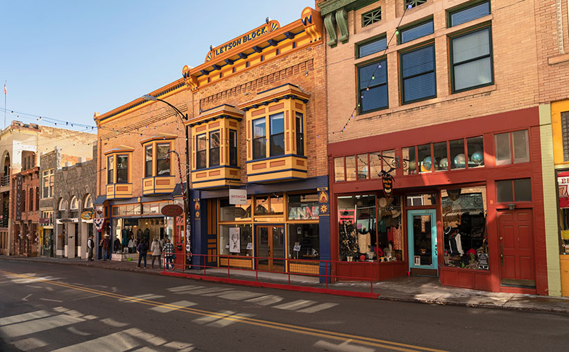
Technicolor Stroll Down Tombstone Canyon - A group strolling down the sidewalk on Bisbee's colorful main street-Tombstone Canyon.
Technicolor Stroll Down Tombstone Canyon – A group strolling down the sidewalk on Bisbee’s colorful main street-Tombstone Canyon.

Welcome back to a new month and a new project! To play a joke on you, I almost sent out a blank post yesterday for April Fools. But, being the clever person you are, I deduced that you’d be too smart to fall for it. So then, I switched days on you and almost sent the prank out this morning, but I realized that you, a person of superior intelligence, wouldn’t be tricked by that ruse, either. Instead, I fooled you and wrote this new article, and you never saw it coming—HA! Inconceivable! Happy April Fools’ Day! – (thanks, Rob)

This month, Queen Anne and I will drag you back to Cochise County and Bisbee because we have a soft spot for this little mining town nestled in the Mule Mountains. Of all of Arizona’s ghost towns, Bisbee has been our favorite since our first visit, sticking with us like a catchy tune you can’t get out of your head. With its mile-high elevation, the weather’s usually pleasant, even in the hot summer months—as if Mother Nature herself turned down the thermostat. Instead of decaying wood shacks, Bisbee’s structures were built to last, and most of them are still standing, like proud survivors of a bygone era. The town boasts a thriving art community and a wide variety of shops, restaurants, and architecture. Oh, and let’s not forget the Copper Queen Hotel, once the poshest place to rest your head between St. Louis and San Francisco, where even its ghosts have high standards.

The Mule Mountains and Bisbee area have a rich natural and geological history. Millions of years ago, the mountains were formed through volcanic activity and shifting tectonic plates, resulting in deposits of copper and turquoise hidden beneath the surface—the juniper-covered Mule Mountains cradle Bisbee, nestled in the folds of its canyons. The region’s unique geological history has also led to the formation of these valuable deposits, shaping Bisbee’s identity as a mining hub. Anne and I enjoy capturing the breathtaking landscape and remnants of the town’s mining heritage. The area’s natural beauty and rich history have made it a true gem in the heart of the Southwest.

Long before the arrival of European settlers and the establishment of Bisbee, the Mule Mountains were already painting a masterpiece in vibrant hues of copper and turquoise, like a natural work of art that only the Hohokam, ancestors of today’s Tohono O’odham and Pima tribes, had the privilege of appreciating up close. These skilled farmers, traders, and artisans were the original caretakers of the land, leaving behind a legacy of pottery, petroglyphs, and other artifacts that offer a glimpse into their rich and colorful culture. The mountains were their muse, the copper and turquoise their paint, and the result is a stunning canvas that still takes our breath away today. The Mule Mountains had always held a special place in the hearts of those who called this land home long before Bisbee became the colorful town it is today.

Bisbee’s European history began in the late 19th century when prospectors discovered rich copper deposits in the Mule Mountains. The town proliferated, attracting miners, merchants, and entrepreneurs worldwide. By the turn of the century, Bisbee was a bustling hub of activity, with saloons, hotels, and shops lining its streets. Bisbee has had its fair share of both good times and bad. The town has a rich history, from its early days as a mining community to its recent incarnation as an artsy, quirky town. But with its history comes some dark moments, such as the Bisbee Deportation of 1917 and the Bisbee Massacre. These events left a lasting impact on the town and its residents, reminding us that Bisbee’s story is not just one of beauty and charm but also struggle and resilience.

This week’s photo is a street scene of Bisbee’s main street—Tombstone Canyon—lined with a row of historic buildings painted in various colors reminiscent of San Francisco’s Painted Ladies. As was expected before WWII, the shops share a common wall to maximize their interior space. The most colorful building is topped with a plaque identifying it as the Letson Block. A small group of pedestrians is walking down the sidewalk; perhaps they’re window-shopping tourists. On the otherwise drab street, reflections of the sun off windows create interesting random rectangles.
Dot's Diner - Don't care to stay in a stuffy ghost-laden hotel. Then head down to the cemetery and stop at Dot's, where you can book a night in an Airstream, Airplane, or Yacht. Besides, it's an excellent place for breakfast in the morning.
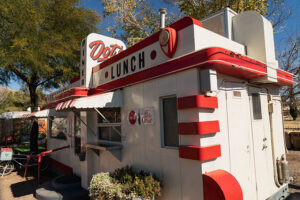
Dot’s Diner – Don’t care to stay in a stuffy ghost-laden hotel. Then head down to the cemetery and stop at Dot’s, where you can book a night in an Airstream, Airplane, or Yacht. Besides, it’s an excellent place for breakfast in the morning.

We hope you’ve enjoyed this week’s photo of Bisbee’s Main Street, showcasing Bisbee’s charm. You can view a larger version of Technicolor Stroll Down Tombstone Canyon on the official website by clicking here. Join us next week for another exciting photo and tale from our favorite ghost town. We can’t wait to share our enthusiasm for this quirky, historic town.

Till next time
jw

BTW:

I told you so. If you haven’t gotten out yet, you need to get going. The fields are awash with flowers now. Grab your camera and get out there.

Lowell Theater Lowell, Arizona

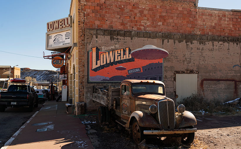
Lowell Theater - A Chevy flatbed truck parked at the Lowell Theater in southern Arizona.
Lowell Theater – A Chevy flatbed truck is parked outside the Lowell Theater in southern Arizona.

It was already well past lunch as we drove up Highway 80. Queen Anne’s all too familiar whining had begun, “I only had one meal today.” We were heading to Bisbee’s Copper Queen Hotel, where we could satiate our hunger. As we approached the Lavender Pit, I noticed an old Shell gas station in my peripheral vision. When I looked in the mirror, I saw that—not only was it real, but an old car was parked outside. That was enough catnip for me to slow the Buick and make a U-turn across four lanes of traffic. Lunch could wait.

When I turned onto Erie Street, I was surprised to see an entire block of old buildings with vehicles of the same period parked out front. Was I on a movie set, or had I died and gone to some photographer’s idea of heaven? I decided it had to be the former because I still heard Anne’s food grumbling in my ear. I was further confused by a wall sign saying, “Welcome to Lowell, Arizona.” I turned to Anne and announced, “We’re not in Bisbee anymore.”

Lowell is to Bisbee as Tempe is to Phoenix—a cling-on. Bisbee and Lowell were founded in the late 1800s as mining claims—Bisbee in the 1870s and Lowell in 1899. As the mines grew, they needed men to work them. Like every other mining town, the population lived first in tents, shacks, and finally, proper homes. Unlike the Tombstone mine, the ore at the Copper Queen Mine and Lowell Mine was so abundant that it supported the towns for over fifty years. That’s why these southern Arizona towns have masonry buildings instead of the rickety shanties of most ghost towns. Bisbee reminds me of the coal-mine towns in Pennsylvania or West Virginia.

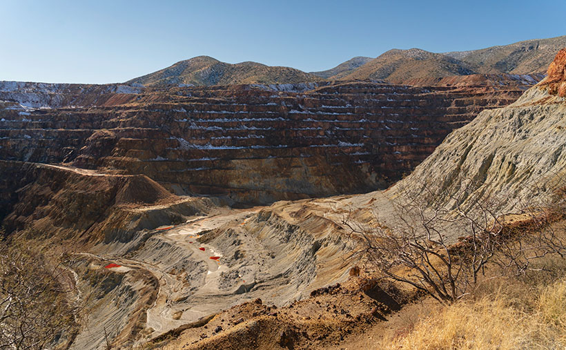
As time passed, the Copper Queen (and Phelps Dodge) took over the operation of the Lowell Company. Underground mines are inherently dangerous, and there was so much copper ore still buried there that during the World Wars, it became economically feasible to build giant machines to scrape away mountains and dig big pits to extract the copper. Bisbee’s renowned scab in the ground is called the Lavender Pit—named for Harrison Horton Lavender (the mine superintendent). As the abyss grew, it took parts of Lowell with it. All that remains of Lowell today is Erie Street which runs from the traffic circle in the south and the pit’s edge on the north side.

Lavender Pit - The famous Lavender Pit mine where tons of copper ore was dug from the ground. The pit is so vast I couldn't fit it all in the frame, even with my wide angle lens.
Lavender Pit – The famous Lavender Pit mine where Phelps-Dodge dug tons of copper ore from the ground. The pit is so vast I couldn’t fit it all in the frame, even with my wide-angle lens.

A group of volunteers banded together and formed the Lowell Americana Project. They worked hard to restore and enhance the quarter-mile street and transform it into an open-air museum. Their hard work got them international attention for their cultural preservation. They have turned Erie street into one of the most photographed streets in the West. Like me, you’ve probably seen some of those pictures in magazines and films without knowing the location.

We’ll explore Lowell’s Erie Street in February, hopefully, to delight my car friends. I consider this week’s photo the foundation shot. It was taken at the north-end parking lot where I left Anne to starve while I skipped up and down the street taking pictures. In this shot, I wanted to show the theater marquee, the Gulf, and the Lowell welcome sign. As an additional no-extra-cost bonus, the town thru in a Chevrolet flatbed truck. I don’t know what year it is, so perhaps one of you gearheads can tell us. I also have no idea about the flying saucers. I didn’t find a reference to any abductions in the area, although more aliens visit Arizona than any other place. They like the weather here—especially at Bisbee’s mile-high altitude. Maybe the spaceships are a warning that you’re about to enter The Twilight Zone.

You can see a larger version of Lowell Theater on its Webpage by clicking here. We’ll begin our walk down Erie Street next week to see what we can find. Be sure to come back then.

Till next time
jw

BTW:

No Queen Annes were harmed in the making of this article. She finally got her lunch and a glass of wine before she fell asleep as we drove back to the motel.

Courthouse Yard The Town Too Tough to Die

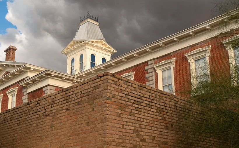
Courthouse Yard - The tall brick wall surrounding the Tombstone Courthouse yard conceal the gallows within them
Courthouse Yard – The tall brick wall surrounding the Tombstone Courthouse yard conceals the gallows within them

Whenever I visit Tombstone, it takes me a while to get oriented. But when I see a town map, I understand why. Unlike most communities established in the Mormon Territory of Deseret, the streets aren’t aligned to the compass points and aren’t centered on an intersection named Central and Main. Instead, the town is 45° off the compass; there’s no Central Avenue, and Allen Street substitutes for Main Street. Given Tombstone’s distance from Salt Lake City and its rough and tumble history, I don’t suspect its citizens weren’t concerned about religions.

When I visit the “Town Too Tough to Die,” I consider the OK Corral its social and geographical heart. As I stand on the corner of 3rd Street and Allen and look the town over, I see the streets lined with one and two-story old wooden buildings. They’re either painted in bright colors or left in their natural dull brown finish. The only exception is a block southwest on 3rd Street. There you’ll see a large two-story brick building trimmed on each of its angles with white stones. On top is a cupola festooned with a widows-walk. The first time you see this pearl before the swine, you instantly know it must be important. It was—is. It’s the original Cochise County Courthouse.

It only took five years from the silver find to the OK Corral gunfight. In that brief time, the population swelled to 7,000, and robberies and lawlessness ran rampant. Wikipedia notes, “Except for the Earp–Clanton feud, which gave Tombstone an extremely bad press—from which it has no interest in recovering—citizens gladly accepted the proffered alternative.” The townspeople wanted a change. More importantly, miners had to make a two-day journey to Tucson to file a new claim. In 1881 two historical events happened; the shootout and the state legislature carved Cochise County out of Pima and made Tombstone its seat. The irony of those events and building the courthouse a block away from the Corral the next year isn’t lost on me.

By 1929 the silver played out, and Bisbee became the next boom town. The copper strike there required more men to work the mine. With a larger population, Bisbee won the county seat in an election, and the government offices moved 25 miles down the road. The old courthouse sat empty between 1931 and 1955. That’s when the local historical society took an interest in it. They began restoring and lobbying using local contributions until the Arizona legislature declared it an Arizona State Park.

In this week’s featured image, I call Courthouse Yard, I tried to capture the gingerbread and grandeur of the red-brick building, but I wanted to emphasize the wall surrounding the side yard. Inside those enclosures is where convicted murderers met justice at the gallows. The first hangings were the perpetrators of the Bisbee Massacre in 1883, while the last was the two men that killed a sheriff and deputy at the Wilson Ranch Shootout in 1899. The tall brick walls were designed to shield the gentle public from the gruesome hangings, but most of the town went inside and watched through the second-floor windows anyway. Incidentally, I like the foreboding clouds hanging above the courthouse.

You can see a larger version of Courthouse Yard on its Webpage by clicking here. I hope you’ll join us next week when we tell another thrilling tale from yesteryear in Tombstone.

Till next time
jw

BTW:

We’re planning to visit Temecula, California, wine country, in the upcoming weeks. I hope to bring home a bottle or two along with the pictures and stories we gather.

Gunfighters The Town Too Tough To Die

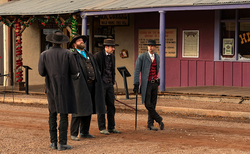
Gunfighters - Actors dressed in Earp costumes try to stay warm on Allen Street while they coax visitors to come see the 3:00 pm show.
Gunfighters – Actors dressed in Earp costumes try to stay warm on Allen Street while coaxing visitors to see the 3:00 pm show.

Ghost towns in Arizona are a dime a dozen. There are enough of them to fill a book. I know because I currently have five of them sitting on my shelves. The morphing of a city into a ghost town follows a familiar pattern. It starts with some loony prospector finding a valuable mineral—gold, silver, copper, diamonds, or another precious stone. News of the bonanza spreads quickly and lures a gaggle of opportunistic people. Half of them want to get rich by picking nuggets from the ground, and the rest want to pick them from someone’s pockets.

A new town springs from the ground like a children’s pop-up book. More people settled in the town and either got jobs at the mine or open shops that every mining community needed, like bars, gambling halls, and whore houses. Eventually—in a year, a decade, or a century—the gold (or whatever) pans out. The excitement of living in a mining town slowly dies, and its residents move on to the next boom town. Mother Nature reclaims the land without caretakers; all that remains is a pile of rotting wood, some foundations, and the eerie spirit of ghosts.

Of course, there are exceptions to my rule. In a handful of cases, when the mine goes bust, its residents look around and say to themselves, “This is a great place to live.” They find other sources of income. I call these places amusement communities. Examples that come to mind include Oatman, Jerome, Bisbee, Bagdad, Clifton, and Tombstone.

Of those locations, Tombstone is the odd duck. There are no gaping open pits to gawk at, historic hotels, or James Beard-worthy restaurants. I suspect that most of its visitors don’t even know about the silver mine. That’s because the silver vein wasn’t gigantic, and that’s how it got the name Goodenough Silver Mine. A gunfight between the Earps and the Clantons secured Tombstone’s historical spot. If it weren’t for that singular gang fight, Tombstone—’The town too tough to die’—would be a pile of splinters by now.

Don’t get me wrong; there is a list of exciting things to see in Tombstone. It was the Cochise County seat for a while, so there’s the old courthouse (with its gallows patio), the Crystal Palace back bar, the world’s largest dead rose bush, and the Birdcage theater should be on everyone’s checklist. Of course, if you have the time and money, you should see the show at the OK Coral, but realize that the actual gunfight was on Highway 80—behind the Coral.

I took this week’s photo on a cold, windy December afternoon. We had checked into our motel and started into town before the light faded. Standing in the middle of Allen Street (dirt, then paved until the street department poured dirt over it again—for authenticity) were four gunfighters dressed in black wearing badges. They tried to stay warm while they hawked visitors to the 3:00 pm show. I don’t know how successful they were because the streets were empty as people sheltered inside the bars. I titled this shot Gunfighters.

You can see a larger version of Gunfighters on its Webpage by clicking here. I hope you’ll join Queen Anne and me throughout January as we show some of the exciting Tombstone scenes we found.

Till next time
jw

BTW:

Queen Anne and I are working on our calendar for the year. We’re putting together a list of places we’d like to visit and this year’s book topics. If you have any requests, let us know in the comments section.

Richardson House Picture of the Week

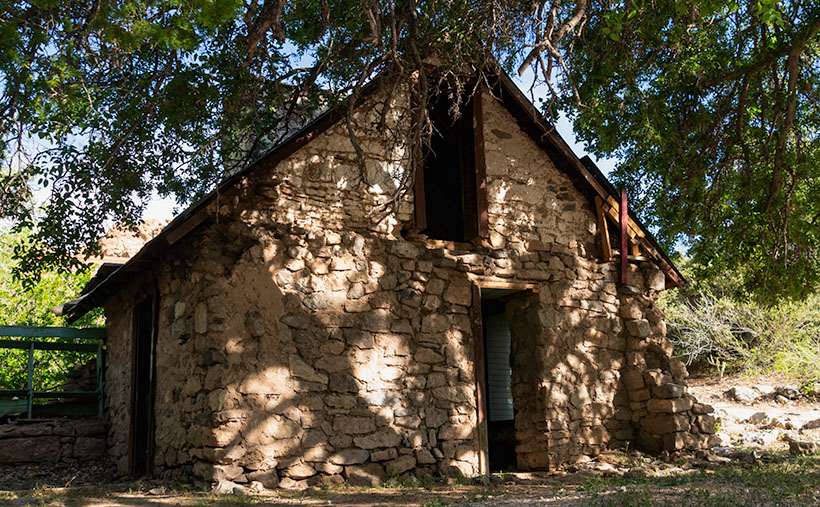
Richardson House - The remains of the home that John Richardson built on their Union Pass homestead.
Richardson House – The remains of the home that John Richardson built on their Union Pass homestead.

At the beginning of May, I had to make another Algodones run. I broke another tooth and needed our dentist to look at it. Since Queen Anne had company, I traveled alone. These frequent dental visits have gotten old. When we travel to Mexico, it’s not for fun. Being an old codger, I’ve been wondering what advice I have for the following generations, and one thing that comes to mind is this: “Kids if you’re hoping to live past 35, take better care of your teeth.” I could have bought a boat with all my money wasted in my mouth.

My stay in the chair wasn’t extended. The doctor looked in my mouth, chattered in Spanish, ground down the pointy parts, handed me a jar of antibiotics, and said, “Come back in two weeks. We need to dig the old tooth out.” They set me free, and it wasn’t even noon.

I could have driven home, but the house was full of visiting women, and I’d be like a third thumb. Since I wasn’t expected home for another day, I drove north, following the Colorado River to Laughlin, where I could enjoy another boy’s night out. I had my camera to tend to some unfinished business.

My featured project after my last Nevada visit in September was the marvelous rock formations near Union Pass. That’s where Mohave County Route 68 crosses through the Black Mountains and begins its descent to the Colorado River. While researching my articles, I learned about the Richardson family and their Union Pass homestead. I told their story in my pBroken Crown post, so I won’t burden you here by repeating it. At that post’s end, I said I wanted to go back and spend some time shooting the homestead’s ruins, and that’s why I spent the night in Laughlin.

Unfortunately, a law of entropy states that things on their own will decay—they fall apart. There’s a set of humans who enjoy helping the process. That’s why I wanted to return to Union Pass soon, and I’m glad I did. Pictures showed the gas pump island cracked but intact. On my visit, someone utterly destroyed it. However, there were enough ruins left that I spent most of the morning wandering and shooting.

The first picture for this month’s Richardson Homestead project is the two-story house hand-built by John using local stone. It is nestled in the shade of an Arizona Ash. The tree covers the two-story structure with the dappled light that I love. Compared with earlier pictures, someone has torn down the large cross on its right side, and graffiti now decorates the front retaining wall (off-camera and purposefully not included). The house is the most intact building on the homestead. With over forty years of neglect, it hasn’t fallen.

I’m sad that Mohave County or the BLM hasn’t set this property aside as a park or a protected historical site. Without that protection, I expect this place to be gone before future generations learn about the Richardsons and their homestead. Although a complete restoration would be ideal, simply keeping it in a state of arrested decay would be the first step. For example, at the Gillespie Dam and Bridge, Maricopa County’s interpretive center was built to explain its historical significance. Something like that would hopefully deter vandals from running amuck. Hand me a petition; I’ll sign it.

You can see a larger version of Richardson House on its Web Page by clicking here. Next week, we’ll pick through the Richardson ruins to find other artistic shots to show you. Be sure to come back and see them.

Till Next Time
jw