Summit Monsoon Picture of the Week

My third grade class picture.
A third-grade class picture from my Catholic School days.

Sister Mary Ellie-Font taught us about purgatory in the third grade—and she wasn’t talking about the Colorado ski resort. Heaven and Hell weren’t enough to cover the petty sins not covered by commandments. So, Catholics came up with alternative punishment to keep us in line. One way or another, we were going to pay for the Big Mac we ate on Friday. Purgatory is a holding cell where we would stay until God had enough free time to sort us out—or someone specifically prayed for our soul. At the age of eight, we learned that you could skate from anything if you had connections.

For the last couple of months, it feels like we’ve been living in that purgatory-like state of limbo. We’re waiting for something to happen. When we got our vaccine shots this spring, we all climbed aboard a trolley to the beach. Now it seems like the streetcar is lurching to a halt, and our confidence in the future is waning.

Back in the spring, Queen Anne and I were eager to get back on the road. We were ready to bring back pictures from foreign lands, exotic cities, and far-off islands. We’re not sure the world is ready for that. With the spread of virus variants and rising infection rates, we’ve decided to play it safe a while longer. After all, we’re still in the same high-risk group as when this pandemic began. Besides, that’s what our doctors suggested.

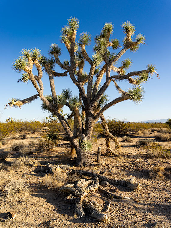
For August, we’re going to hang around our neighborhood, but I wanted to bring you something different. Last week, I wrote about the monsoons and how they brought much-needed rain and spectacular evening light shows. So, this month I’m featuring monsoon clouds—the prettier side of our summer rainy season instead of the floods and muck on the evening news.

Summit Monsoon - Thunderstorms build over the mountains by day, and then move down to the desert floor in the evenings.
Summit Monsoon – Thunderstorms build over the mountains by day and then move down to the desert floor in the evenings.

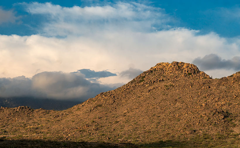
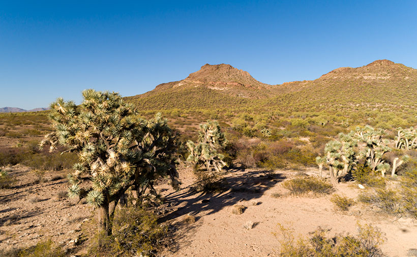
I took this week’s picture in our town’s natural amphitheater—where the old mine and pioneer cemetery is. It shows one of the Date Creek Range’s low peaks and thunder clouds building over the distant Weaver Mountains. The storms only happen when enough moisture moves up from Mexico. Then, the billowing thunderheads form high over the Bradshaw Mountains and flow into the desert. The rain cells are not particularly big, so we never know where it will rain—some nights, we get dust and wind, and other evenings we get drenched. However, the winds cool off the air enough to watch the show from the front porch, making the summers bearable.

You can see a larger version of Summit Monsoon on its Web Page by clicking here. Be sure to come back next week to see the next image that I bagged on my cloud hunt.

Until next time — jw

Summer Joshua Picture of the Week

Nature diligently gives us clues about seasonal changes. When it comes to summer’s onset, I tolerate most of them. There’s a specific one that I’d be happy to skip. It’s the seasonal appearance of our first rattlesnake. When we moved into our little shack in Congress, our neighbors said that they rarely see one—maybe one shows up in the subdivision. However, we personally are averaging close to one a year. Since we spent our first summer in Alaska, there’s no telling how many slithered through the yard while we were gone, so we don’t know how many we missed in 2016.

This one—Sid, as Anne called it for some reason—showed up Thursday morning—our dump day. We always look forward to Thursdays because it’s our day out on the town. We gather our weekly trash and recycle and take it up to the dump. After that, we’ll swing by Nichol’s West for our usual eggs Benedict breakfast.

This week—while Anne prepared herself for the public—I emptied all the bins and boxes then loaded them into Archie. When she was finally ready, we opened the back door, and there Sid greeted us like a Jehovah’s Witness with a sack full of Watchtower magazines. Mind you; I had already been through that door a half dozen times. I have no idea the direction from which he came, but he seemed to enjoy sunbathing on the back-door mat.

I won’t bore you with an account of the ensuing battle because it went down pretty much like last year’s encounter, but I learned a couple of lessons that morning. The first is that there’s still a gap in the decking that I need to plug. The other thing I learned from our stare-down was more important. That little varmint struck at me a couple of times, and I had time to pay attention to his rattles. They’re softer than I expected, and they’re the same pitch as my tinnitus. That means that when I’m out stomping around the desert, I have to be vigilant about spotting them first because I’m deaf to their warning sound. Of course, the only time I’ve ever spotted a rattler; it’s been in our backyard.

Summer Joshua - Joshua trees shed unnecessary leaves to help get through the hot summers in the desert.
Summer Joshua – Joshua trees shed unnecessary leaves to help get through the hot summers in the desert.

There were no snakes around when I shot this week’s featured image called Summer Joshua. On our journey north on U.S. 93, the next landmark that I wanted to show you was the large area of Joshua Trees. Because so many grow along this section, it’s called Joshua Tree Parkway. It’s a north-facing 13 mile downhill slope on which the giant lilies thrive.

The Joshua is dense along this part of the road, so when I found this isolated specimen, I stopped and asked if it would sit for a portrait. Even with the fallen limbs in the foreground, this is a healthy plant, and you can see one of its heat survival secrets. Actually, you can’t because the secret is the sparse foliage. Like most Sonoran Desert plants, the tree only has the minimum amount of leaves to keep it alive. That strategy cuts down on water evaporation, a scarce commodity around these parts. The old dry foliage folds and covers the branches, which helps cool the plant the same way people use parasols for shade. Cool being relative, because when I shot this image, the air temperature was 105° even though the time was after 5:00 pm.

You can see a larger version of Summer Joshua on its Web Page by clicking here. Next week, we’ll continue north and find another landmark along US 93, so ya’ll come back now—eh?

Until next time — jw

Date Creek and Tres Alamos Picture of the Week

Working during the summer is challenging, whether in house chores or photography. That’s why my favorite pastime during these months is procrastination. Face it; I’m allergic to heat. Thinking about going outside is worse than actually doing so. After all, in today’s southwest, we’ve learned to minimize our heat exposure. We move about in a succession of air-conditioned cocoons.

Heat is why I had difficulty coming up with a theme for  July. The monsoons haven’t kicked in yet, so most pleasant campsites are on fire or closed. I must stay close to home, venturing early or after dinner, find a shot, and then hurry home.

I decided that July’s theme will be U.S. Highway 93. That’s the main thoroughfare near my house that Phoenicians (and Tucsonans) use to commute to Las Vegas. The route goes to Canada, but I’m only concerned about day trips. Because I’ve often traveled the section between here and Kingman, I know a few vistas I wanted to capture on film but never had time to stop. This week’s image is an example.

Date Creek and Tres Alamos - Date Creek as it flows by the Tres Alamos Wilderness Area near Congress, Arizona.
Date Creek and Tres Alamos – Date Creek flows by the Tres Alamos Wilderness Area near Congress, Arizona.

North of the SR 71 – 93 junction, the Alamo-Congress Rod is a lousy shortcut to Alamo Lake. It’s a broad dirt road that gets graded annually at best. It passes the Tres Alamos Wilderness Area about 10 miles west of the paved highway. It’s a small nature preserve (83,000 acres) compared to the neighboring Arrastra Mountain Wilderness (129,800 acres). The high point on which Tres Alamos is centered is the 4257-foot Sawyer Peak. To reach the spot where I took this shot, I had to slowly travel a couple of miles on a Jeep trail that left Archie with some Arizona Pinstripes—a badge of honor for a Luxo-SUV.

The wash in this shot is Date Creek, which should be familiar to regular readers because Congress—and the old Congress Gold Mine—are located next to the mountains of the same name. As it were, the creek flows from the Weavers, along the north side of the Date Creeks, to where it merges with the Santa Maria River upstream from Alamo Lake.

An interesting thing in the photo is the tire tracks in the sand. With the rising popularity of those all-terrain buggies, it’s easier for off-roaders to drive through the washes. Most of the time, the ride is smoother than the so-called mine roads. However, in the past, you could see tracks of the animals crossing the river bottoms. It was a visitor guest book. Now that natural history is erased each time they drive over it.

When I first moved to Congress, I coveted owning an ATV. I thought it would help me get into the backcountry and get some unique landscapes. After a couple of rides in Fred’s, I found them uncomfortable because you’re exposed to the elements, and riding in his air-conditioned FJ is more my style of roughing it. Earlier this year, I got hooked on watching Matt’s Off-Road Recovery. He’s a towing company in Hurricane, Utah, and he documents his crew on YouTube as they drag 4-wheelers back to civilization. The best part is that he uses a modified Corvair Lakewood—the station wagon version. Watching him drag ATVs off mountains and dunes convinced me I was better off without one.

Click here to see a larger version of Date Creek and Tres Alamos on its Web Page. Next week, we’ll travel further down the highway and see what’s around the next bend.

Until next time — jw

Skull Valley Depot Picture of the Week

I’m not considered a sociable person, so you may be surprised that I joined a car club back when I was a younger man—more than half my life ago (oh jeez, where has it all gone). This club’s existence was based on owning a particular brand—which one isn’t important for my story—but the club member’s general attitude was that no one should drive one of these cars because the mileage brought down their value. Insane, I know. Despite that, the club put on well-attended events like parties, tours, meetings, and track days.

The club event that drew the most participation was their annual progressive dinner. If you’ve never heard of that, it’s a three to seven-course dinner served at the volunteers’ houses who prepared each course. So we’d meet at the appetizer house, have a glass of wine, and when the food was all gone, we’d jump in our cars and drive to the next course. The club paid for the food and a couple of jugs of Carlo Rossi wines, and members paid a flat per-head attendance fee. The club made a lot of money. Things were different then. Phoenix had few roads north of Northern Avenue, and traffic was nil on Saturday nights, so by the end of the evening, the drive between houses turned into a Targa Florio race. Half the club would wind up in the slammer on DUI charges these days, and the insurance companies would cancel their policy.

Now hold that thought in the back of your head while I talk about the other part of another one of my grandiose ideas. I’ve written before about the trains that pass our house. They run less than a half-dozen times each day (and night), so the tracks are empty most of the time. The route runs from Phoenix to the northern town of Ash Fork, and it has so many twists and turns that it was dubbed The Peavine Line when it opened a century ago. The tracks run through the heart of Arizona’s historic gold mining country.

Historically our little train used to carry passengers with depots in Phoenix, Wickenburg, Congress, Kirkland, Skull Valley, Prescott (now bypassed), and Ash Fork. Most of the town’s stations are still there in one form or another. And—unlike the routes between Phoenix to Tucson and Phoenix to Yuma—there is some interesting backcountry scenery and at least two climate zones along the journey.

Skull Valley Depot - The townspeople of Skull Valley have put their abandoned depot to good use as a local museum.
Skull Valley Depot – The townspeople of Skull Valley have put their abandoned depot to good use as a local museum.

So, after my photo outing where I shot this week’s featured image in Skull Valley, I began to fantasize about having a progressive dinner—on a train. The trip would start in Wickenburg (or maybe Sun City West), then make scheduled stops where the old stations are. At each stop, you could peruse the local museum, enjoy the designated course, spend money on useless trinkets in the gift shop, pee, and get back on the train. Between stations, the guests could taste wine samples (from Arizona vineyards?) and purchase bottles that they would pick up at the evening’s end. At the end of the line, the train would make a leisurely two-hour trip back to the station. The night will have fallen by that time, and guests would enjoy non-alcoholic beverages to sober them up.

I only know of two train excursions in Arizona; the Verde River Line and the trip from Williams to the Grand Canyon. There once was the White Mountain steam train, but that closed a long time ago, and Durango bought the engine (which fell off the trailer along US 89—however that’s another story). I think there’s plenty of market for another train ride in our state, and the dinner would make it a unique experience. Think of it as a dinner cruise on rails.

If this lame-brain idea sounds good to you, then it’s yours. On the other hand, if you feel it’s a stupid idea, I never said anything. My brain hurts too much to work on stuff right now. I’m too old and penniless. Besides, it’s time for my nap.

You can see a larger version of Skull Valley Depot—the picture that set my brain on fire this week—on its Web Page by clicking here. Be sure to come back next week when we continue with another Skull Valley artifact.

Until next time — jw

Joshua Tree Below Picture of the Week

Everyone has several traits that make up their personality, and psychologists measure these traits by where they fit on a line—called a continuum. The most common example is being an extrovert or an introvert. Most people fit in the middle, of course, but some people are really outgoing and unconstrained, while others are shy or withdrawn. I’ll bet, off the top of your head, you can name several people on either side of that teeter-totter.

Another—lesser-known—continuum is thrill-seekers. Even if you’re not adventurous, you’re still somewhere along that line—maybe just right of center. You can name friends that will jump out of a perfectly good airplane while others avoid sidewalk cracks. I’m a moderate risk taker, but there are certain things I won’t do. I’m not too fond of roller coasters, for example. More accurately, I don’t like the initial weightless drop—I’m fine with the sharp twists and turns throughout the ride’s latter part.

Another fun thing that I can’t make myself do is bungee jumping. I’m confident that the hosts know what they’re doing, and the physics have been worked out to the last decimal place. I also know that with my obesity, jumping off a bridge would lead to my premature demise. And I can tell you exactly how it happens.

I’d have to watch at least a half dozen people come back alive before I summoned up the courage to give it a try. Once I put on the helmet and harness, I’d be trapped. Somehow, I’d climb up on the railing and stand there for an eternity before closing my eyes and jumping. That’s just the beginning of the end. When that feeling of weightlessness first hit my stomach, I’d spew the old Technicolor yawn. As I fell through the air, I’d be surrounded by atomized droplets of my morning breakfast. Then at the bottom, I’d start the rebound only to find out that Galileo was wrong. I’d hurtle upstream through my own mouth shower. At the apex, I’d catch a whiff of my own stench and spew second upchuck, and I would fall through that mess a second time. But—at the bottom—the overstressed bungee cord catastrophically fail, and I’d do a belly flop on the ground. As I lie there, a gentle vomit mist would fall, covering my lifeless body. For a final insult—and as everyone who watches South Park knows—your bowels release the moment you die. No one would ever volunteer to come and clean up that mess. The authorities would throw a blue tarp over me, and that spot would become my forever resting place.

Joshua Tree Below - The sight of a pointy object, like this Joshua Tree, hurtling towards you should make you reconsider skydiving in the Sonoran Desert.
Joshua Tree Below – The sight of a pointy object, like this Joshua Tree, hurtling towards you should make you reconsider skydiving in the Sonoran Desert.

What motivated me to consider my tragic demise was this week’s featured image—Joshua Tree Below. All I intended to capture was a different view of one of our Joshua Trees—the large tree in the second image, to be exact. But, when I processed the photo, it became obvious why no one should skydive in the Sonoran Desert—no matter where they lie on the Thrill Seeker Continuum.

Black Mountain Joshua - The large Joshua Tree before Black Mountain is the model I used for this week's featured image.
Black Mountain Joshua – The large Joshua Tree before Black Mountain is the model I used for this week’s featured image.

You can see a larger version of Joshua Tree Below on its Web Page by clicking here. Be sure to come back next week when we begin a series of photos from Skull Valley.

Until next time — jw