Crystal Palace The Town Too Tough to Die

Crystal Palace - When we travel to Tombstone, we make a point of stopping in the Crystal Palace and admire its back bar.
Crystal Palace – When we travel to Tombstone, we make a point of stopping in the Crystal Palace to admire its back bar.

How adventurous are you? Do you try new things or stick with the tried and true when you return to a location? I’d say that Queen Anne and I are 25/75 split. We always seem to return to the joints we’ve enjoyed but try to see what else is out there. I’m unsure if that’s adventurous or what other people usually do.

That holds for Tombstone as well. It may not be a surprise that when we get to town, one of our first stops is a bar—not just any bar, but we specifically make a beeline to the Crystal Palace. We don’t go there because the beer is cold or the wine is vintage; let’s face it, beer is beer, and bar wine is—ugh. When we are belly-up to the bar, the alcohol is only a vessel for a toast to a great piece of furniture—the Crystal Palace back bar.

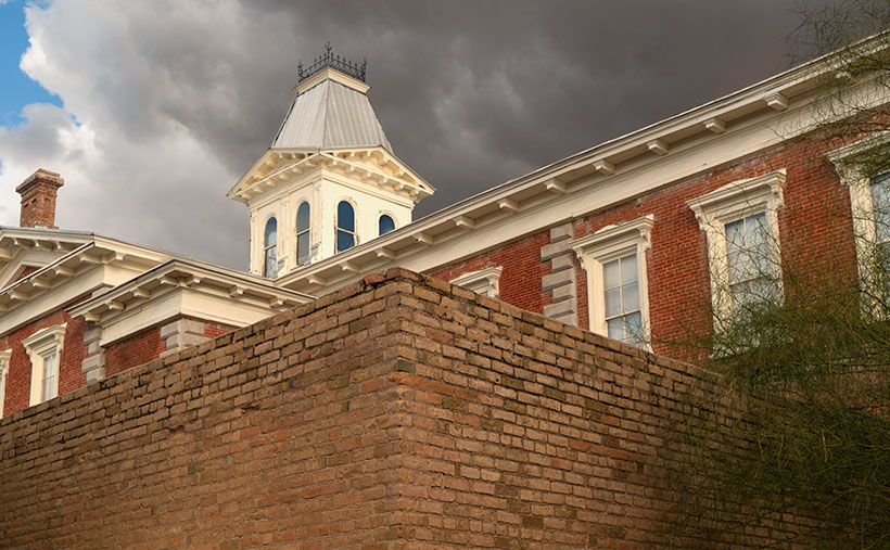
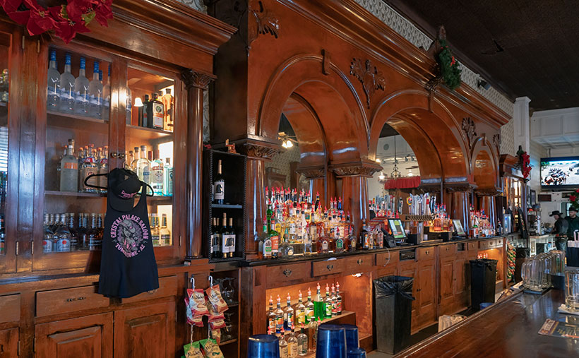
The Palace is on the south end of town on Allen Street. During winter, they keep the front doors closed, but you can bust your way through a pair of a traditional cowboy swinging doors during summer. As you look around the cavernous room, you’ll see a bigger-than-life roulette wheel hung as wall art. The ceilings are two stories high and covered in stamped tin tiles. There’s a stage along the back wall where rows of cancan girls danced. On the room’s left is a massive mahogany back bar dwarfing the bartenders. The room smells of stale beer, French fries, and hamburgers smeared on a leather saddle.

The cabinet that is the source of our admiration reaches about three-quarters of the way to the ceiling. It has three arches supported by Corinthian columns with mirror inserts. I wonder how often those mirrors were targets of bullets or flying cowboys. It looks like one piece, but I’ll bet there’s a seam hidden beneath the center trim and festoon. On each of its flanks are matching liquor hutches. If you don’t have time to drive to Tombstone, you can see its twin sister in one of Prescott’s Whiskey Row bars (I don’t recall exactly which bar it was because I spent too much of my life doing research for this article).

We don’t grow mahogany in Arizona or any other hardwood that would be nice enough for cabinets like this. This one was ordered from furniture makers in New England and then shipped around South America’s treacherous Cape Horn (no Virginia, the canal wasn’t yet built). Once the sailboat reached the Sea of Cortez, the bar was unloaded and carried overland by wagon.

If you’re hungry, you can order food. It’s not the worst place in town, but it’s still bar food. They prepare onion rings in-house, notably better than those awful versions at Jack’s or The King. If the tour busses are in town, the place will be packed, and the crowd can overwhelm the staff. Then you’ll have to be patient with your food and bill. But it’s not any better at the other restaurants.

There is one more thing about the Crystal Palace that I should warn you about—especially in spring. For some reason, enough couples are getting hitched in Tombstone; the town provides them with sideshows. On one of our visits, we noticed a table full of guys having a bachelor’s party. They had a great time drinking beer and being loud when suddenly an attractive woman dressed in a bright red dance costume burst through the swinging doors. She was followed by three men with handlebar mustaches wearing long black dusters and deputy badges. The young woman walked over to the groom-to-be and pointed her finger at him. She shouted for the entire world to hear, “That’s him! That’s the slime ball. Last night he promised to love me forever, and today he’s running off with another woman.”

Then the deputies grabbed the scoundrel under his arms and dragged him through the side door to the hanging tree out back. The crowd emptied the bar and filled the streets. Once there, the posse strung him up but stopped until someone fetched the bride.

Once she arrived (accompanied by her entourage), the lawmen presented their case. After hearing what they had to say, she promised that after their wedding, she’d set him straight, and he would never do it again. The sheriff polled the crowd, “Do you believe her?”

Most of the mob said yes, so he removed the noose, and we all went back into the bar and ordered another beer—on the groom.

I called this week’s picture Crystal Palace, and it’s of the cabinets described in my story. I was happy that my shot was sharp in such a dark room without using a flash or a tripod. I lightened the wood in post-production to show off its luster and grain. To get a clean shot, I had to wait for the bartenders to go to the kitchen window. Sometimes it pays to be patient.

You can see a larger version of Crystal Palace on its Webpage by clicking here. I hope you’ll join us next week when we come back with another Tombstone story.

Till next time
jw

BTW:

Are you ready for flowers? With the frequent rain this winter, we will have a bumper crop of wildflowers. Now is the time for you to come up with some strategery on where to go to photograph them.

Courthouse Yard The Town Too Tough to Die

Courthouse Yard - The tall brick wall surrounding the Tombstone Courthouse yard conceal the gallows within them
Courthouse Yard – The tall brick wall surrounding the Tombstone Courthouse yard conceals the gallows within them

Whenever I visit Tombstone, it takes me a while to get oriented. But when I see a town map, I understand why. Unlike most communities established in the Mormon Territory of Deseret, the streets aren’t aligned to the compass points and aren’t centered on an intersection named Central and Main. Instead, the town is 45° off the compass; there’s no Central Avenue, and Allen Street substitutes for Main Street. Given Tombstone’s distance from Salt Lake City and its rough and tumble history, I don’t suspect its citizens weren’t concerned about religions.

When I visit the “Town Too Tough to Die,” I consider the OK Corral its social and geographical heart. As I stand on the corner of 3rd Street and Allen and look the town over, I see the streets lined with one and two-story old wooden buildings. They’re either painted in bright colors or left in their natural dull brown finish. The only exception is a block southwest on 3rd Street. There you’ll see a large two-story brick building trimmed on each of its angles with white stones. On top is a cupola festooned with a widows-walk. The first time you see this pearl before the swine, you instantly know it must be important. It was—is. It’s the original Cochise County Courthouse.

It only took five years from the silver find to the OK Corral gunfight. In that brief time, the population swelled to 7,000, and robberies and lawlessness ran rampant. Wikipedia notes, “Except for the Earp–Clanton feud, which gave Tombstone an extremely bad press—from which it has no interest in recovering—citizens gladly accepted the proffered alternative.” The townspeople wanted a change. More importantly, miners had to make a two-day journey to Tucson to file a new claim. In 1881 two historical events happened; the shootout and the state legislature carved Cochise County out of Pima and made Tombstone its seat. The irony of those events and building the courthouse a block away from the Corral the next year isn’t lost on me.

By 1929 the silver played out, and Bisbee became the next boom town. The copper strike there required more men to work the mine. With a larger population, Bisbee won the county seat in an election, and the government offices moved 25 miles down the road. The old courthouse sat empty between 1931 and 1955. That’s when the local historical society took an interest in it. They began restoring and lobbying using local contributions until the Arizona legislature declared it an Arizona State Park.

In this week’s featured image, I call Courthouse Yard, I tried to capture the gingerbread and grandeur of the red-brick building, but I wanted to emphasize the wall surrounding the side yard. Inside those enclosures is where convicted murderers met justice at the gallows. The first hangings were the perpetrators of the Bisbee Massacre in 1883, while the last was the two men that killed a sheriff and deputy at the Wilson Ranch Shootout in 1899. The tall brick walls were designed to shield the gentle public from the gruesome hangings, but most of the town went inside and watched through the second-floor windows anyway. Incidentally, I like the foreboding clouds hanging above the courthouse.

You can see a larger version of Courthouse Yard on its Webpage by clicking here. I hope you’ll join us next week when we tell another thrilling tale from yesteryear in Tombstone.

Till next time
jw

BTW:

We’re planning to visit Temecula, California, wine country, in the upcoming weeks. I hope to bring home a bottle or two along with the pictures and stories we gather.

Dos Cabezas Mountains Picture of the Week

Dos Cabezas Mountains - The 'two head' mountain range is a prominent landmark in southeast Arizona.
Dos Cabezas Mountains – The ‘two head’ mountain range is a prominent landmark in southeast Arizona.

Memorial Day has snuck up on us already. The unofficial summer season begins today. Back east, our friends and family have opened swimming pools, drug their Webber grills out of the garage, and finally put on shorts—with white belts and black socks. Meanwhile, here in the desert, we’re beginning to think of clever ways to stay cool for the next three months. This year, Queen Anne and I have come up with some new places to visit, but we have to stop buying food to have gas money.

Before worrying about surviving June and its 110º temperatures, we need to finish May. So, let’s return to our Cochise County Road 186 project, jump into the car, and find one last shot. Then we can drive into Willcox, where I know of a decent Mexican restaurant for dinner.

With the ghost town of Dos Cabezas in the rearview mirror, the county road begins to drop from the foothills into the Sulphur Springs Valley. All of the time, the ‘two-headed’ mountain range looms in the east. The south head blocks its northern twin brother from town, so we will drive several miles until both outcrops are visible. That turned out to be a spot where I could hike past a ranch gate and get this week’s picture.

At first glance, the range resembles a two-headed giant with 15-mile broad shoulders that I’ve seen in cartoons. The twin heads are weathered granite, and the highest one (the south) is 8,354 feet in elevation. That’s not as impressive as it sounds because the valley floor has an average height of 4,000 feet above sea level, but Interstate 10 still detours several miles north of the left shoulder to get around the range. A dirt road on the range’s south side divides the Dos Cabezas and Chiricahua ranges. That road goes to the historic site of Fort Bowie through the ominous Apache Pass. Since that road served as the main trail from New Mexico into Southern Arizona, the Cavalry built the old fort to quell the frequent ambushes by renegade Apaches.

I call this photo Dos Cabezas Mountains because I have a vivid imagination. The sky looked clear and blue, but a few clouds to the south cast shadows over the range. Fortunately, that saved this image from being flat and lifeless. The dark-green patches near the mountain top are tall ponderosa pines. In this picture, the land traverses three climate zones, and that’s an example of why the patches of Coronado National Forest are called Sky Islands. Finally, the San Simon Valley and New Mexico are on the other side of these mountains.

You can see a larger version of Dos Cabezas Mountain on its Web Page by clicking here. Next week, we begin searching for summer refuges, but before we load the Jeep, I will return to a previous location as promised earlier this year. Be sure to come back and see what I’m talking about.

Till Next Time
jw

Adobe Ruin Picture of the Week

Adobe Ruins - In the ghost town of Dos Cabezas, most of the remaining buildings are severely decayed.
Adobe Ruins – In the ghost town of Dos Cabezas, most of the remaining buildings are in a severe state of decay.

Roughly midway between Willcox and the Chiricahua National Monument, the county highway’s speed limit drops to 45 mph. At first, there’s no clue about the slowdown until a small sign announces that you’re entering the town of Dos Cabezas. Only three of its dozen or so buildings are worthy of occupancy. The rest are in various states of decay. It’s only a city block long, and you soon return to an empty country road, where you can reset the cruise control.

After driving through Dos Cabezas three times, I insisted on stopping on our fourth pass. As regular readers know, I’m a sucker for historic buildings, whether they’re restored or about to be blown down by the wind. I’m glad that I did, and this week’s featured shot is one of several that I captured during that afternoon.

As with most Arizona ghost towns, Dos Cabezas’s history is a flash of glory followed by a long decay period. The town is located at the southeastern reach of the mountain range, which shares the same name. When word came out that prospectors discovered gold and silver on the mountain, miners swooped in like hungry vultures to feed on a carcass. The Feds opened a Post Office in 1878, which served a population of 300 that eventually swelled to over 4000. They found little gold in the Elma mine, but there were some copper deposits. Investment capital dried up when investors discovered that the mine was a scam and part of stock fraud. People left to find work elsewhere. As the town dwindled, the Post Office finally closed its branch in 1960. I guess that you could count today’s Dos Cabezas citizens on one of your hands.

In this picture that I call Adobe Ruin, you see the remains of a large building constructed using adobe bricks and stucco. The town once had a hotel, and these sections may be all that’s left of it. Adobe was a common building material throughout the old southwest because it was simple to make. All you need is to combine mud and straw and let it dry in the sun. The thick bricks provide plenty of protection from the desert heat and cold winters, but they quickly erode once water enters them.

I took several variations of the building, but I favored this one because I liked the mud stains streaking down the wall, and I liked the wall’s placement before the background’s two-headed mountain. The desert willow and hackberry show how soon nature reclaims her own. Ashes to ashes, as it were.

You can see a larger version of Adobe Ruin on its Web Page by clicking here. Next week, we’ll walk down the street to look at another of the Dos Cabezas ruins. Come back then and have a look.

Till Next Time
jw

Cochise Ranch Airfield Picture of the Week

Cochise Ranch Airfield - It's common for ranchers in remote Arizona communities to build private airfields.
Cochise Ranch Airfield – It’s common for ranchers in remote Arizona communities to build private airfields.

As a kid, one of the Saturday morning cowboy shows I watched was Sky King. The pitch for the show probably went something like this: An Arizona rancher has a spread so large that he has to use an airplane to manage it. Because our rancher (let’s call him Sky King) has this fantastic resource, the local sheriff calls on him to help find lost hikers, bank robbers, missing children, and commie spies. It’s pretty unbelievable—right? But that’s how it went. Sky King was not my favorite cowboy because he didn’t have a pretty horse. After all, how could you chase bandits and shoot at them if you weren’t riding a horse?

I don’t know about chasing bank robbers, but large ranches with private airfields are common in Arizona. I didn’t realize how pervasive they were until I studied to get a drone license and learned how to read aeronautical charts. There are several private fields near where we live.

I can think of several reasons you could justify a private field if you lived in a remote place like Cochise County. Flying into town for supplies would be helpful, but you’d need a fair-sized plane to bring home packs of Costco paper towels and toilet paper. We have trouble getting those items in our Jeep. Emergency medical visits are second on my list off the top of my head. The rancher files to a hospital, or Air Evac comes out to the spread.

The Sky King Memory block fell into my recollection dispenser when we drove by this windsock and hanger on our commute between Willcox and Chiricahua National Monument. That’s why I stopped and took this shot. I call this week’s picture Cochise Ranch Airfield, and it shows a weathered water tank, orange sock, and corrugated hanger before a clear blue sky. As you look at it, you can hear the announcer’s golden voice saying, “From out of the clear blue of the western sky comes Sky King!” Now that we’re all older and more cynical, don’t you wonder why Penny—a pretty young blond pilot and accomplished air racer—lived alone out in the desert with her flashy old uncle?

You can see a larger version of Cochise Ranch Airfield on its Web Page by clicking here. Next week we’ll stop in a ghost town and look at some of its ruins, so I’m sure that you’ll want to see that.

Till Next Time
jw