Four Peaks: The Crown Jewel of the Mazatzal Mountains Picture of the Week - Fountain Hills, Arizona

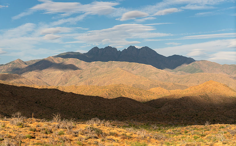
Four Peaks in the Mazatzal Mountains: Majestic mountain range against a backdrop of lenticular clouds and blue sky.
Four Peaks: The Crown Jewel of the Mazatzal Mountains – A captivating view of Four Peaks and the dramatic play of lenticular clouds in the Arizona sky.

Yea! We’ve made it over the hump. Now we start whittling away the second half of 2023. But first, we must suffer through the insufferable—our monsoon season. As we enter the scorching summer months in Arizona, fleeing from the heat becomes a top priority for Phoenicians. We seek refuge in the pleasant mountain landscapes outside the city to beat the relentless triple-digit temperatures and humidity. But hey! I’m here to help, so July’s photo project involves one of the escape routes Phoenicians by the thousands use each weekend—the Beeline Highway.

It’s been at least a decade since I last drove Arizona State Route 87, but last month, my friend—and regular contributor—Fred asked me to help him fetch some trailer equipment in Heber—a small community on the Mogollon Rim. As he drove through the rugged mountains to Payson, I rode shotgun and thought, ‘I forgot how spectacular this scenery is. I need to come back with my camera.’ That’s when I decided to do July’s Mazatzal Mountains project and use the Beeline Highway for our trail. It sure beats hiking.

The name—Mazatzal—is a directive of a tribal word the Spanish picked up from the native Indians, Mazatzalli—meaning ankle bone. The Yavapai thought these mountains resembled an ankle when viewed from certain angles. Situated northeast of Phoenix, the Mazatzal Mountains stand as a rugged and formidable barrier, marking the gateway to the Rim Country. These majestic peaks serve as a scenic backdrop for Phoenicians as they embark on their journey to the Mogollon Rim and its surrounding areas. While the Mazatzals offer breathtaking vistas and a sense of natural grandeur, access to their remote backcountry is primarily reserved for avid hikers, horseback riders, and outdoor enthusiasts seeking a more adventurous experience. It’s important to note that due to the rugged nature of the terrain and limited facilities, the Mazatzals may present challenges in terms of accessibility, especially for individuals with mobility restrictions.

As we travel along the Beeline Highway, we traverse a physical distance and ascend through a tapestry of changing climates and vegetation. From the arid lowlands near Phoenix, we gradually ascend into cooler uplands adorned with diverse flora. We witness transition from cacti-dotted desert landscapes to lush pine forests and high-altitude meadows. This elevation-driven change in vegetation is a constant reminder of the varied ecosystems thriving within the Mazatzal Mountains.

This brings us to this week’s image—Four Peaks: the Crown Jewel of the Mazatzal Mountains. This image is my latest attempt to capture the highest point in Maricopa County. Well, they’re the highest four points in the county. From left to right, they’re named: Brown’s Peak (7657′), Brother Peak (7642′), Sister Peak (7572′), and Amethyst Peak (7524′). On the afternoon that Queen Anne and I stopped to take this image, it was windy, and the sky was filled with lenticular cumulus clouds (cirrocumulus clouds that look like lenses). As they crossed the sky, they cast shadows on the mountain, adding depth and drama to the composition. Without the shadows, the mountain would appear flat and featureless.

Thank you for joining us on this virtual journey through the Mazatzal Mountains. We invite you to share your experiences and memories of these stunning landscapes. Feel free to connect with us and the community as we continue exploring this magnificent region’s natural wonders. Stay tuned for our next installment, where we delve deeper into the heart of the Mazatzals.
Sugarloaf and Sycamore Creek: Impressive rock formation and desert landscape in Arizona's back-country.
Sugarloaf: A Gateway to the Majestic Mazatzal Mountains – When the Beeline Highway passes between Four Peaks and this landmark, you know you’re finally out of town and into the Mazatzals.

If you’d like to see a larger version of Four Peaks, you can do that in several ways. The first is to visit its Webpage using this link (https://www.jimwitkowski.com/newWork/fourPeaks.html). Miss Deb reported last week that the second method works only if you use a desktop computer. Follow this link (https://fineartamerica.com/featured/four-peaks-jim-witkowski.html) to my posting on Fine Art America. Please hover your mouse cursor over the image until a green square appears (they’re magically delicious). Select the area you want to inspect, and then click. A one-to-one preview window of that section will open on the screen.

Till Next Time
jw

Techniques: Embracing the Elements and Finding Drama in Nature’s Surprises

Photography is a dance with elements; sometimes, the most captivating images come from natural surprises. As photographers, we can embrace these elements and find beauty and drama in their presence. The photo of Four Peaks with its lenticular cumulus clouds and their resulting shadows is a prime example of how nature can add a touch of magic to our compositions. When faced with unique cloud formations, we may be tempted to wait for them to clear, fearing they will obscure the peaks. However, there is value in embracing the unexpected and capturing the scene as it unfolds. By incorporating the lenticular cloud shadows, the image takes on a new level of depth and intrigue. The shadows play across the rugged mountain terrain, accentuating its contours and adding drama to the composition.

When you find yourself amid nature’s surprises—a sudden storm, an unexpected play of light, or unusual cloud formations—embrace them. Explore their potential to add depth, drama, and a touch of magic to your photographs. Remember, breaking the rules or deviating from your initial plans can lead to some of your most captivating and memorable images.

Arlington’s Abandoned Feed Mill: Fading Memories of Cattle Country Picture of the Week - Arlington, Arizona

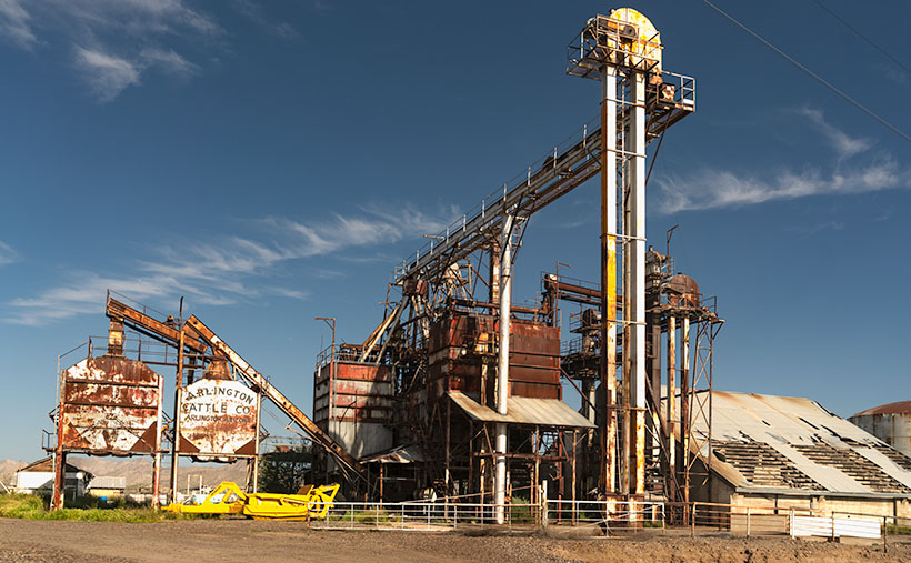
Abandoned farm equipment at Arlington Cattle Company
Arlington’s Abandoned Feed Mill – The abandoned grain hoppers and silos of the Arlington Cattle Company were left to rust in the Arizona desert.

Last week, I wrote about the exceptional rainfall we had in Arizona and how the wildflowers love it. Well, the same wet winter that showered our land with nature’s colorful confetti also brought heavy mountain snowfall. Since the predicted snowmelt and runoff would overflow our reservoirs, the Salt River Project began releasing water into the river. It’s been quite a while since we have had water in our ordinarily dry riverbeds. While some may scoff at the idea of water in Arizona’s riverbeds, I was thrilled that I might get the chance to shoot some whitewater rapids in the desert.

I convinced Queen Anne to go-for-a-ride(?) a couple of weeks ago. We drove down the west valley to the Gillespie Bridge, excited at the prospect of capturing the raging torrents of water. However, upon arrival, we were met with disappointment. The river was spent and lethargic when the artificial flood passed through Phoenix. The snowmelt’s aftermath left us with sluggish, murky water oozing through the tamarisk. It looked more like effluent than a river. Feeling disheartened, we started to return home when I noticed the stunning light falling on the machinery at the Arlington Cattle Company. When I stopped the car and grabbed my camera, Anne responded, “Hurry up! I’m Starving.”

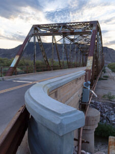
The Gila River begins its journey in New Mexico’s Gila Mountains. It collects water from its tributaries, including the Salt River, the Verde River, the Santa Cruz River, the New River, the Agua Fria River, and the Hassayampa River. The Gila River embarks on an audacious westward journey, carving its path through untamed landscapes. Just after the confluence of the Gila and Hassayampa rivers, the Gila turns south for thirty miles towards Gila Bend. As the river flows past the Buckeye Hills, it enters a natural pinch point several miles down old US 80. It passes between a formidable silhouette of a volcanic sentinel and the edge of Gillespie Shield Volcano. The black rock lava flow rises two or three stories above the road and river and is known for its impressive pictographs, visible along the cliff of lava rock when examined closely. At this pinch point, pioneers attempted to build three versions of the dam. After they all failed, the highway department erected an all-season bridge to cross the river. Local farmers plant the dam’s old flood plains in summer with deep green cotton, making the little valley a desert oasis.

I’ve been to the Arlington Cattle Company before, so this wasn’t my first time photographing this abandoned equipment. The last time I photographed there was over a decade ago; the massive boom that sent grain over the road to the feed lots there had collapsed into the canal flowing along the roadside. Someone has cleaned that mess up since then. As I stood and framed the shot, I could hear the ghostly sounds of machinery banging, gears meshing, and belts squealing in protest. The equipment stands as a testament to the relentless march of time, bearing the scars of decades past, with the weathered vestiges of industry adorned in hues of faded silver and rust contrasting against the intense blue sky. However, what catches my eye in this photo is the tall silver elevator, which towers above all else, and with the sun’s reflection, it appears as a beacon against the bright blue sky. The wispy white clouds in the background are a bonus and provide a nice contrast to the earthy tones of the equipment.

The Arlington Cattle Company was established in the early 1900s by a group of investors led by William W. Clemens, who also served as the company’s president. The company purchased approximately 55,000 acres of land in the Arlington Valley and constructed a state-of-the-art cattle feeding facility. The company aimed to fatten cattle for the market using a combination of locally grown grains and hay from nearby farms.

The facility stood as a cathedral of innovation, a testament to the audacity of human endeavor, featuring a grain elevator that could lift and store thousands of bushels of grain at a time. The elevator was powered by an extensive motor and conveyor system that could move the grain from the elevator to the various silos and feedlots throughout the property. The company also built a vast network of canals and irrigation ditches to ensure a reliable water supply for the crops (and cattle).

Despite the initial success of the operation, the Arlington Cattle Company struggled to turn a profit. The company faced several challenges, including drought, floods, and fluctuations in the price of beef. In addition, the company’s location in a remote part of the state made transportation difficult and expensive. As a result, the company was forced to declare bankruptcy in the early 1920s. After the default, the land and equipment were sold to various buyers. Today, the rusting equipment seen along the roadside in the Arlington Valley are the only remnants of the Arlington Cattle Company.

Rustic Gillespie Bridge spanning the Gila River with a mountain in the background
Old US 80 Bridge at Gila River – The historic Gillespie Bridge at Gila River, part of Old US 80, features a rusted iron truss structure and spans over the water with a volcanic rock mountain in the background.

I hope you enjoyed this week’s photo and reading about the Arlington Cattle Company and the old farm equipment that still represents Arizona’s ranching history. Don’t forget to check out the larger version of Arlington’s Abandoned Feed Mill Cattle on our website by clicking here. Join us next week for more fascinating stories and photos of farming equipment, from the old to the new. And who knows, maybe we’ll even find something borrowed and blue. Thanks for reading!

Till next time
jw

Courthouse Yard The Town Too Tough to Die

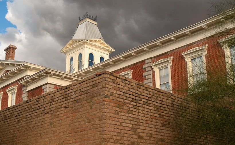
Courthouse Yard - The tall brick wall surrounding the Tombstone Courthouse yard conceal the gallows within them
Courthouse Yard – The tall brick wall surrounding the Tombstone Courthouse yard conceals the gallows within them

Whenever I visit Tombstone, it takes me a while to get oriented. But when I see a town map, I understand why. Unlike most communities established in the Mormon Territory of Deseret, the streets aren’t aligned to the compass points and aren’t centered on an intersection named Central and Main. Instead, the town is 45° off the compass; there’s no Central Avenue, and Allen Street substitutes for Main Street. Given Tombstone’s distance from Salt Lake City and its rough and tumble history, I don’t suspect its citizens weren’t concerned about religions.

When I visit the “Town Too Tough to Die,” I consider the OK Corral its social and geographical heart. As I stand on the corner of 3rd Street and Allen and look the town over, I see the streets lined with one and two-story old wooden buildings. They’re either painted in bright colors or left in their natural dull brown finish. The only exception is a block southwest on 3rd Street. There you’ll see a large two-story brick building trimmed on each of its angles with white stones. On top is a cupola festooned with a widows-walk. The first time you see this pearl before the swine, you instantly know it must be important. It was—is. It’s the original Cochise County Courthouse.

It only took five years from the silver find to the OK Corral gunfight. In that brief time, the population swelled to 7,000, and robberies and lawlessness ran rampant. Wikipedia notes, “Except for the Earp–Clanton feud, which gave Tombstone an extremely bad press—from which it has no interest in recovering—citizens gladly accepted the proffered alternative.” The townspeople wanted a change. More importantly, miners had to make a two-day journey to Tucson to file a new claim. In 1881 two historical events happened; the shootout and the state legislature carved Cochise County out of Pima and made Tombstone its seat. The irony of those events and building the courthouse a block away from the Corral the next year isn’t lost on me.

By 1929 the silver played out, and Bisbee became the next boom town. The copper strike there required more men to work the mine. With a larger population, Bisbee won the county seat in an election, and the government offices moved 25 miles down the road. The old courthouse sat empty between 1931 and 1955. That’s when the local historical society took an interest in it. They began restoring and lobbying using local contributions until the Arizona legislature declared it an Arizona State Park.

In this week’s featured image, I call Courthouse Yard, I tried to capture the gingerbread and grandeur of the red-brick building, but I wanted to emphasize the wall surrounding the side yard. Inside those enclosures is where convicted murderers met justice at the gallows. The first hangings were the perpetrators of the Bisbee Massacre in 1883, while the last was the two men that killed a sheriff and deputy at the Wilson Ranch Shootout in 1899. The tall brick walls were designed to shield the gentle public from the gruesome hangings, but most of the town went inside and watched through the second-floor windows anyway. Incidentally, I like the foreboding clouds hanging above the courthouse.

You can see a larger version of Courthouse Yard on its Webpage by clicking here. I hope you’ll join us next week when we tell another thrilling tale from yesteryear in Tombstone.

Till next time
jw

BTW:

We’re planning to visit Temecula, California, wine country, in the upcoming weeks. I hope to bring home a bottle or two along with the pictures and stories we gather.

Clouds Over Craters Picture of the Week

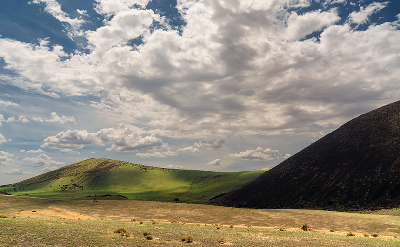
Clouds Over Craters - Monsoon clouds fill the sky over a pair of volcanic craters at the San Francisco Lava Field in northern Arizona.
Clouds Over Craters – Monsoon clouds fill the sky over a pair of volcanic craters at the San Francisco Lava Field in northern Arizona.

Tomorrow is Halloween, and the east coast has already had its first dusting of snow. Only last week, I had to switch from my daily summer uniform (t-shirt and shorts) into my winter outfit (t-shirt and jeans). I only wear long pants because my feet get cold with poor blood circulation. Otherwise, I’d wear shorts throughout the year—as men do in New Zealand. The last time we went to their islands, we saw road crews dressed in down parkas, shorts, and flip-flops.

I’m not boasting about our two seasons here in the desert; hot and less hot. Everybody back east already knows about our climate. In a couple of weeks, they’ll be camping in RV Parks throughout our state. This week’s rant is about why good things always come with baggage (this isn’t about Queen Anne either—stop that, you’re nasty). For example, as a kid, do you remember stretching out on a freshly cut lawn on a breezy summer’s eve so you could stare into the black sky and count shooting stars—only to be eaten alive by chiggers? Right there, that’s what I’m talking about.

Sitting at my computer, enjoying my first sweater of the season, and processing this week’s photo, I liked how lovely the monsoon clouds were. In Navajo lore, the gathering of puffy sheep in the sky foretells the coming summer rains. Our summer clouds are dynamic. They form over the mountains in the morning. They build and tower into the stratosphere and then charge into the desert with a triple fury of wind, dust, and frog-choking rain. By midnight, they disappear, and stars come out of hiding. It’s the opposite of the winter clouds that travel down the coast. They’re a homogenized grey sky, hanging around for days like a bowl of lumpy oatmeal. As I closely studied this week’s picture, I realized that the monsoon season might be my favorite time of the year—if it wasn’t so damn hot and muggy.

I named this week’s image Clouds Over Craters, and I took it at the S.P. Crater location I featured a couple of weeks ago. The dark blob on the right side is S.P. Crater, and the lesser volcano in the distance is unnamed. The grass growing on its slopes indicates that it’s rainy season. The crater’s shape and color remind me of Hawaii’s Diamond Head in a mirror. The diagonal scratches are from ATVs digging up the soil as they claw their way to the top. I could have Photoshopped the scars, but I wouldn’t say I like that. Besides, the clouds are the star of this show, both in the sky and the shadows they cast on the craters.

You can see a larger version of Clouds Over Craters on its Webpage by clicking here. It’s the finale of the San Francisco Lava Field project, and next week we’re at a new location. Here’s a clue—it’s across the street. Want to take a guess? We’ll see you when you return next Sunday to find out if you’re right.

Till next time
jw

BTW:

Since November is next week, it’s time for me to lay out my 2023 calendar. I make at least one for myself each year, but I’ll happily print another copy for you. Because I order them in low numbers, they’re an expensive wall calendar. When hanging, they’re the size of a copy paper sheet—they fit nicely between my desktop and cabinets. VistaPrint has dropped the small-middle-binding option this year so that they will be coil-bound along the top. When I add the shipping cost, they cost me $18.00 each, which is what I charge for them. I want to have them for Christmas, so if you want to be included, let me know by the 15th of November. That way, I’ll expect them after Thanksgiving. You can email me directly, leave a message on my Contact Page, or if I already have your email address (you’re a subscriber), you can order in the comments below (I’ll strip your email address from public comments).

Colton Crater Juniper Picture of the Week

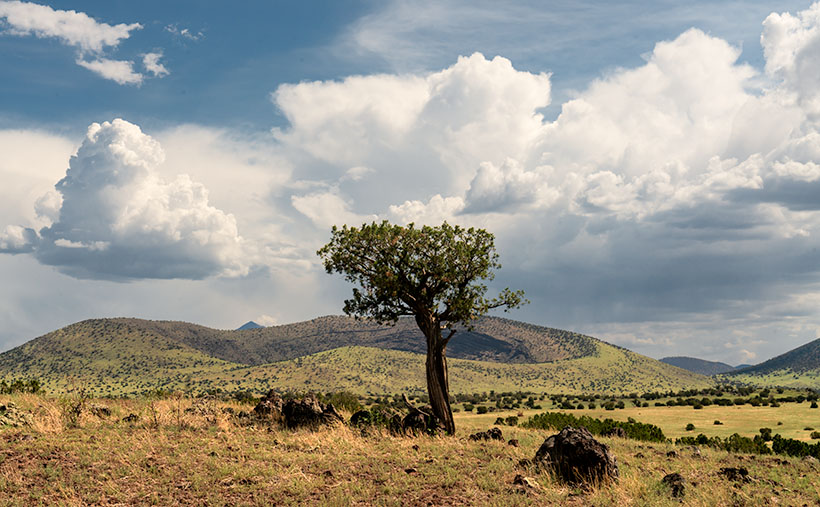
Colton Crater Juniper - A lone juniper surrounded by lava bombs stands before Colton Crater topped with monsoon clouds.
Colton Crater Juniper – A lone juniper surrounded by lava bombs stands before Colton Crater, topped with whipped cream monsoon clouds.

I’m unsure where my head was last week when I wrote that today was the last Sunday in October. It wasn’t until the middle of the week that I realized I was wrong, and another weekend was ahead. Don’t worry; I have one more photo from the San Francisco Lava Field that I’d like to show you. You’re so lucky.

Queen Anne and I didn’t have to travel far from S.P. Crater to find this week’s scene. She didn’t move at all. She sat in the Jeep and continued to read her Kendal while I walked due south across the dirt road to a tree that I found interesting. I composed my shot as I walked toward the juniper. I wanted to include the monsoon clouds building over the San Francisco Peaks and some of the lava bombs surrounding the tree; otherwise, I would have moved closer to capture its twisted trunk. When I finally processed the photo this week, I realized that I had grabbed another volcanic crater—it’s a twofer. I’d rather be lucky than good—it takes up less time.

The cone in this week’s shot is Colton Crater. It looks like a fallen birthday cake. No amount of icing will cover that mess up. Compared to the mountain I featured last week, this one doesn’t seem impressive. It doesn’t look tall and well-formed like S.P. Crater. That’s only an optical conclusion. Colton has more height and width, and the caldera is deeper. And there is another smaller cone inside Colton’s caldera. You’ll have to look on Google Earth or hike its rough grade to see it. Incidentally, along the horizon, the small pyramid-shaped peak is Mt. Humphreys—Arizona’s highest mountain peak.

The reason that Colton looks old and saggy is the same as why I do; it’s an old fart. While S.P. Crater’s last eruption was only 55,000 years ago (a baby), Colton Crater hasn’t seen any action in 200k – 800k years. That’s plenty of time for gravity and erosion to bring a mountain to its knees. For example, the interior of Colton’s crater has been swept clean of residual ash and pumice from its eruption.

Scientists don’t name things very creatively. They tend to give out codes instead of names. For most of the time that geologist has been studying the San Francisco Peaks, this crater was called V160. It was the 160th volcanic flow in the lava field. See what I mean—where’s the romance in that? Dr. Harold Sellers Colton was the founder and director of the Museum of Northern Arizona in Flagstaff, and after he died in 1970, the local academia renamed Volcano 160 in his honor. That was nice.

You can see a larger version of Colton Crater Juniper on its Webpage by clicking here. Come back next week when we finish our tour of the San Francisco Lava Field with one last photo. This time I’m sure—I looked it up on my calendar. We’ll see you then.

Till next time
Jw

BTW:

I have an old friend from my California racing days named Gary Wheeler. You might have read some of his comments in this journal. Since his retirement, he has been taking some fantastic bird photographs. I don’t know; maybe old racers turn to photography when they’re too old to do anything useful. After much urging, Gary has put his collection online for people to enjoy. If you enjoy birds, you should pay a visit at: https://gowheeler.smugmug.com/. Don’t worry; he didn’t pay me for this advertising.

Sycamore Point – and – Calendars     Picture of the Week

Trick or Treat
smell my feet
give us something good to eat

Since this is my first-ever Halloween post, I couldn’t pass that up.

So, where were we? Oh yes—Queen Anne and I spent an afternoon exploring and photographing along the back roads to Sycamore Point. The sun was going down, and we wanted to get back to Williams to have a nice dinner at The Red Raven Restaurant.  Before we leave, let me get in one more shot.

Sycamore Point - From Sycamore Point, looking back over Thumb Flat to Bill Williams Mountain.
Sycamore Point – From Sycamore Point, looking back over Thumb Flat to Bill Williams Mountain.

I call this week’s photo Sycamore Point. If it isn’t apparent, I took it with my drone. Unlike a normal camera, you can’t spontaneously whip it out and start flying about—well, not if you want to keep your license. You have to file a flight plan, conduct a pre-flight check, and there are no fly areas. In this case, I couldn’t fly it past the wilderness boundary (you can get an exception from the BLM—but that takes weeks).

The truth is that I took several drone shots of the canyon, but because the drone’s camera lens is ultra wide, the images from my Sony were better, so I used those. Since the drone had battery time left, I turned it around and pointed the camera toward the road we traveled. From an altitude of two-hundred feet, this is the image that I got.

When I started processing this photo, I realized that it has everything that we’ve been talking about during October. In one image I see Alligator Juniper, patches of yellow wildflowers, Thumb Flat, the edges of Sycamore Canyon, burn scars, the back road, shafts of sunlight, and in the distance, the Northern Arizona Volcanic Field—including Bill Williams Mountain (center left) and The San Francisco Peaks (far right). It’s like you’re back in school, and here’s the chapter review before the test—but from a different perspective.

You can see a larger version of Sycamore Point on its Web Page by clicking here. Next week, it’s time for a new project from a different location. You’ll want to come back and see what trouble I got myself into this time.

Calendars

This year is hurtling to an end already, so it’s time for me to make new calendars. In spite of the extra cost last year we got a nice response. Inflation has taken a toll again this year. After reviewing my printer’s price list and post office shipping costs, I need to charge $20.00 for them. I know that cost is prohibitive to most of you, but they’re a limited item. I need to get one for myself and if you’re interested, I’ll print a copy for you.

The pictures for the 2022 edition are from this year’s outings. The size remains the same—6 ½ inches high (each half—about the size of a sheet of paper folded in half) and 8 ½ inches wide, and they have holidays noted on the dates. They’re printed on card stock—which is part of the expense.

In order to get them to you for Christmas (and we’re cutting it close according to the Post Office), I need to know by November 10th. If you’d like one, you can leave a comment in this post, use the contact form on my website (https://www.jimwitkowski.com/junk/index.php), or email me directly. Don’t forget to leave your contact information if I don’t already have it.

Until next time — jw

Thumb Flat   Picture of the Week

With a basic knowledge of native Arizona plants and observational skills, it’s easy to tell what elevation you’re at in our state. Maybe only Florida is easier because the entire state is below 350′. I’ve written before about how State 48 has all but two of the world’s climate zones; sub-tropic and tundra permafrost. So all you have to do is look at the bush you’re standing next to you for a clue.

For example, compare last week’s picture to the one that I posted today. The tall ponderosa pines you see in Yellow Field thrive at altitudes over 6,500 feet. While the pinion pine in this week’s image—Thumb Flat—is the dominant plant between 5,000 and the appearance of tall pines. My rule is only a rough generalization because there are microclimate pockets all across the state. I can name two places off the top of my head as examples; Palm Canyon in the KOFA Range south of Quartzite and the east slope of the Poachie Range south of Wikiup. The state’s only native palms grow in a mountainside crevice at the first location, and the latter has saguaro and pinion pine intermingling on its slopes.

When Queen Anne and I visited Williams, it was only natural as we drove down the south slope of the dormant volcano to see ponderosa pine replaced with stands of juniper. As the White Horse Lake Road descended even lower, the juniper became sparser. By the time we reached Thumb Flat—as it’s called on the map—individual trees had stood alone in the wildflower-covered fields.

Thumb Flat - A beautiful alligator juniper stands in a wildflower covered field.
Thumb Flat – A beautiful alligator juniper stands in a wildflower-covered field.

Here I spotted this beautiful alligator juniper, which made me stop Archie and get its portrait. I think this specimen would be a prized possession in anyone’s garden. Probably the only reason this tree isn’t already in somebody’s front yard is that it’s in the middle of the Kaibab National Forest.

In this week’s featured image that I call Thumb Flat, I like how the foreground is darker in color from being in the shade of a cloud. It contrasts nicely against the bright white background cumulus clouds. The wildflowers are the same as in last week’s image, but you can see how much more dull they are when they’re not in direct sunlight. In this case that’s OK because they’re not the subject here—this week, they’re only playing a ‘walk-on’ part.

You can see a larger version of Thumb Flat on its Web Page by clicking here. Next week, we turn onto another side road, so come back and see where that road ends.

Until next time — jw

P.S. If the picture is not showing up in your email version of this post, you can click on the article title (Thumb Flat) to open the Web version of this post.