Dune Avalanche Picture of the Week

Dune Avalanche - When the angle of wind-blown sand meets or exceeds 35 degrees, the sand collapses under its own weight and slides down the dune's leeward face.
Dune Avalanche – When the angle of wind-blown sand meets or exceeds 35 degrees, the sand collapses under its weight and slides down the dune’s leeward face.

My sisters and I never got to play in sandboxes when we were toddlers. My dad said it was because the cats kept covering us (cue drum). That joke was the extent of my dune knowledge until this month’s project. It turns out that they’re pretty complex.

For example, I thought they were a large pile of uniform sand grains. Not so. Only the grains on the surface layer are the same. Below—about a yard (or a meter, if you’re Canadian)—is another layer where the sand grains are large enough that wind can’t lift them. The surface has even more refined grains that get picked up and suspended in the air—like dust—and carried to faraway places. Recently, scientists found that dust from the Sahara Desert is held aloft high in the trade winds and falls back to earth in the Amazon Rain Forest. The settling dust is the source of nutrients supporting jungle plants. The soil in that area of Brazil is otherwise nutrient-poor because the river constantly flushes everything out to sea.

The weirdest fact that I learned was that dunes could sing—not like in tunes from Rocky Horror Picture Show—but a deep booming bass note (70-100 Hz). Conditions have to be perfect. The sand must be dried (in the hot summer), it must be windy, and the dunes must be tall—120 ft or more. The Algodones Dune field is not that high, but the Dumas Dunes between Barstow and Las Vegas are, so now I have to hear this for myself.

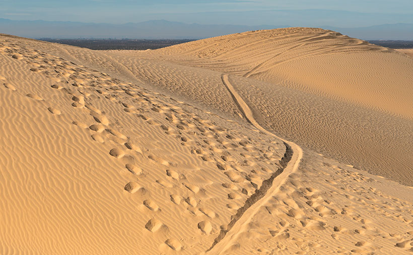
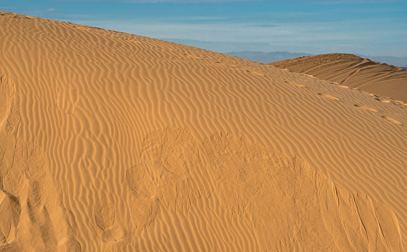
Here’s how it works. As wind moves over the field, the windward face of the dune forces air up and move faster—like an airplane wing. The fast-moving air picks up sand from the middle of the face and drops the sand at the top. When the angle of the top sand exceeds 35 to 38 degrees, it’s not able to support its weight, and it begins to slide down the dune’s leeward face—as we see in this week’s image called Dune Avalanche, but on a larger scale. As the sand slides, it creates vibrations reflected off the denser layer beneath—like the strings and body of a cello work together to make music. If you’d want a more thorough explanation from a more credible source, you can watch What Makes These Dunes Sing? (ft. @It’s Okay To Be Smart) on YouTube, but be warned, you need a good bass response from your speakers, or you won’t hear the song. And you thought last week’s story about the sandworms was fantastical.

I took this week’s picture at the Imperial Dunes Recreation Area, as you can guess by the tire tracks in the background. When I saw the sloughing sand, I knew that it was essential to the ecology of the dunes, but I didn’t appreciate why. After this week’s research, I’m glad that I snapped the photo, and—as I said above—I want to check out the Dumas Dunes and maybe go back to Death Valley. I want to hear their song—but do I want it bad enough to go when it’s 120 degrees?

You can see a larger version of Dune Avalanche on its Web Page by clicking here. Next week we’ll poke more into the beauty of the Algodones Dune Field, so come back then.

Until next time — jw

Predator Tracks Picture of the Week

We need to drive an hour to show you a different part of the Algodones Dunes. I hope you had breakfast because we’re not stopping. There are only two roads that cross the dunes, Interstate 8—east of Yuma and California State Highway 78. We’ll hop onto I-8 and head west to Holtville, then north to Brawley.

Most of this drive is flat and dull except for the towering green John Deere tractors that take up three lanes of the two-lane road. The farmers drive them on public roads to remind you that if you eat steak and salad in winter, this is where they were likely grown—either here in the Imperial Valley or Yuma.

Once we get to Brawley (there’s a bypass, so thankfully, we don’t have to go into town), we’ll turn west onto S.R. 78—the road to Blyth (boy, it keeps getting worse, doesn’t it). It isn’t far out of town that you see a cloud bank on the horizon—or at least that’s what it appears to be. The sand reflects light on a bright day, and the detail gets lost. The shapes and color begin to resolve in another mile, and the windshield fills with an overwhelming sea of golden sand.

We have arrived. This area of the dunes is the home base for So Cal dune-buggy enthusiasts. As soon as the highway starts up the sand, you’ll see Gecko Road on the right. It’s a paved street loaded with vendors, campers, and rangers. This road is a fee area, so we may have to buy a permit if the rangers come to work today. There are several designated camping areas along the road, and they’re full of R.V.s and trailers—even in the middle of the week. Judging from the size and luxury of these rigs, they’ve come from the L.A. Basin—and they’re richer than anyone from Arizona. There must be a thrill racing up and down dunes; otherwise, what’s the point? I wouldn’t try it in Archie, but with Bluto, I might. It could be fun.

Predator Tracks - An innocent victim was snatched from her friends by a giant sandworm California's Imperial Dunes .
Predator Tracks – An innocent victim was snatched from her friends by a giant sandworm in California’s Imperial Dunes.

It can also be dangerous. Some creatures live in the sand that nobody’s seen—their tracks are the only evidence that they’re real. They’re called sandworms, and they feed on unsuspecting victims as they try to cross. It’s true; they were in the ’90s movie Tremors, and you can see for yourself in this week’s picture called Predator Tracks. In it, you see footprints from a herd of bikini-clad tawny blond valley girls, moving north across the sand while staring at their phones. They were defenseless because they ignored their parent’s warning to take a chainsaw.

As they incessantly chattered about their Instagram likes, they overlooked the sandworm lurking behind a distant mound. Like dolphins feeding on a school of mackerel, the sandworm blindsided the girls. From their midst, it snatched Cassie in its massive jaws and drug her under as she complained about losing all her bars. None of the others noticed. They continued to the snack truck making snide remarks about how Cassie had just ghosted them. The only record of this tragedy is the tracks in the sand in my photo. Within a couple of days, even those will blow away.

You can see a larger version of Predator Tracks on its Web Page by clicking here. Next week we’ll hang around the Imperial Dunes and see what other sand tracks we can find.

Until next time — jw

Dune Moon Picture of the Week

When Queen Anne and I make our quarterly medical run-to-the-border, the drive is usually three-hours each way. Most of the time, we leave at dawn, see our dentist, buy prescriptions, and then come home. For me, those are long days behind the wheel; for Anne, not so much. She’s usually asleep in the passenger seat until her snoring wakes her up.

Occasionally when we have lab work done, or the customs line is three-hours long because the snow-birds have arrived, we’ll get a room in the elegant east-side Motel 6 and dine at the swanky four-star Denney’s. Our December visit was one of those occasions. Since I needed a topic for January’s posts anyway, we spent an extra night and took a circuitous route home—we’d go up to Blyth to work the Algodones Sand Dunes for this month’s project.

The great swath of sand starts about three miles south of the border outside of Los Algodones, Baja. It continues 45 miles northwest into the Coachella Valley (California’s Imperial Valley). They’re the most extensive contiguous dune system in the U.S. The dunes are also called the Imperial Dunes, Glamis Dunes, and Gordon’s Well. The name varies with location and the leisure activity you’re doing. Still, the entire system is officially named Algodones Dunes (in Spanish, it means cotton plant—the predominant crop grown on both sides of the border along the Colorado River). This week, we’ll start west of Yuma at the Mexican border—at Gordon’s Well.

Imagine it’s 1850, and you’ve traveled by wagon hundreds of miles across the scorching Sonoran Desert, forded a raging Colorado River, and finally crossed into California. You’d think your hardships are behind, but then, you’re greeted with 6 miles of Sahara-like sand to cross. With each step, you sink up to your knees. Even in 1926, when the nation’s first Ocean to Ocean highway was built (U.S. Route 80), the shifting sand was an engineering nightmare. They couldn’t simply scrape the sand away because the prevailing wind constantly covered it up again. Even today, if you’re caught in a windstorm along this section of road, you’ll risk a chance that the sand will blast the paint off your car.

Plank Road - You can see what's left of the old plank road on display at Gordon's Well.
Plank Road – You can see what’s left of the old plank road on display at Gordon’s Well.

The road builder’s solution for getting across was to build a plank road—movable wood sections on railroad-lie ties that floated on the sand’s top. It turned out to be challenging to maintain, but it drastically cut the crossing time when it was clear. Eventually, the planks were replaced with new and expensive asphalt, and eventually, it became Interstate 8. There is a section of the original plank road at Gordon’s Well on display. When you grow tired of looking at the old wood road, you can walk over to the border wall and lean on it.

Dune Moon - A waning gibbons moon setting over the Algodones Dunes west of Winterhaven, California.
Dune Moon – A waning gibbons moon sets over the Algodones Dunes west of Winterhaven, California.

As Anne and I drove west on the freeway, we spotted a waning moon setting on the dunes, so we looked for a place to stop. We’ve got stuck in these sands once before, so we were careful not to drive off the blacktop. I didn’t want to pay for another hook to come to yank us out. As you can see, we found a good spot and took this week’s picture called Dune Moon. The name could have been funnier if I had shot it during a particular summer month. Se la vie.

You can see a larger version of Dune Moon on its Web Page by clicking here. Next week we drive north up the Imperial Valley to visit the northern dune crossing. Be sure to come back and see what we found.

Until next time — jw

Santa Lucia Cows Picture of the Week

Until this week, May has been pretty nice. The temperatures in Congress were pleasant enough that Queen Anne and I could enjoy coffee on the back deck in the morning and have happy hour on the front porch where we watched the daily parade go by. Our nights had been quite cool. By managing the airflow—opening and closing the windows at the right times—we succeeded in keeping the hot afternoons at bay.

All of that came to an abrupt halt on Wednesday. With this latest round of high pressure crossing our State, the evening air didn’t cool off as fast or as much. We finally had to turn the air conditioning on for the season. On top of the heat, people have started new brush fires each day, so I have to accept that summer has come to the desert.

Santa Lucia Cows - A small herd of black cattle graze on a hillside of emerald grass at sunrise.
Santa Lucia Cows – A small herd of black cattle grazes on a hillside of emerald grass at sunrise.

I don’t want to go into the inferno without a fight, though, so I went back through the photos from our recent California trip. I wanted to remember the great morning I spent photographing the sunrise on the Santa Lucia coastal mountain range. There was a slight breeze on top of the hill where I waited in the dark, but my wool sweater was enough to ward off any chill. As I worked my way from the top to the coast road, it seemed like someone was painting in the black shapes with color—like in a coloring book. As the sun cleared the horizon behind me, I stopped along the road to capture a herd of cattle grazing emerald green grass on a hillside. It’s this week’s featured image, and I called it Santa Lucia Cows. As I worked on it this week, I wondered why we didn’t stay in Cambria for the whole summer.

I want to give credit to the artist that influenced me to take this picture. I’m glad that I was able to buy three of Eyvind Earle’s works in my life. They’re all small pieces because I couldn’t afford the six-figure larger ones. If you ever watched the movies Snow White, Sleeping Beauty, or Cinderella then you’ve seen his work. He painted backgrounds for Disney films. That was his day job, but he painted scenes along California’s Central Coast on the weekends. His style was graphical and modern impressionism. His trees and animals had exaggerated long shadows—often bigger than the subject itself. I suppose it’s Eyvind’s fault that I’m always on the lookout for long shadows.

You can see a larger version of Santa Lucia Cows on its Web Page by clicking here. Now I have to snap out of my memory, put on some shorts, and get back to work, so why don’t you please come back next week and see if I found anything good.

Until next time — jw

Beach for One Picture of the Week

Did you really think that we would leave California without bringing back a beach shot? No way—that would be unconstitutional. Whenever Queen Anne and I visit the Morro Bay area, we always save an afternoon for a drive up the Big Sur coast. Sometimes we make it to Carmel for lunch; sometimes, we’re blocked by a landslide—like this year.

Getting to Monterey Bay isn’t the point; there are traditions we have to uphold. As we pass by San Simeon, we point to and wave at the hilltop castle. A stop at the elephant seal colony is required to watch them sleeping on the beach. If we’re not planning a full drive, we’ll pick up a bottle of local wine, some cheese for Anne, and Italian deli meats for me. There’s a beautiful little beach under that famous bridge featured in all the postcards you see, and we spend a couple of hours picnicking on a blanket while we search for Japan on the Pacific horizon.

Four Elephant Seals - With mating season over, four young female elephant seals can finally nap on the warm sun without those big galoots accosting them.
Four Elephant Seals – With the mating season over, four young female elephant seals can finally nap in the warm sun without those big galoots accosting them.

Because of this year’s landslide, we didn’t even make it to our picnic spot. Instead, we drove leisurely along the Pacific Coast Highway to the spot where Caltrans turned back traffic. From the pull-out, we could clearly make out the slide area just south of our bridge. It still looked like Big Sur; only a section of the road was missing. The ocean below was full of silt that turned the water mud brown. It surprised me that it hadn’t settled during the month since part of a mountain fell into the sea.

With the rest of the afternoon to kill, we made our way back to Cambria, frequently stopping to take pictures of beaches, flowers, seals, and the San Simeon lighthouse. I was disappointed that the grounds were posted as a “No Drone Zone” because I had such a great shot planned.

Back in the village, we had one last dinner out and then stopped at the local liquor store. We found out a little secret during our last trip. It’s fun to taste the new vintages at the vineyards, but the liquor store (and the Circle K), sells bottles at discount prices. We sadly went back to the motel with the few bottles we bought and prepared for the long drive home.

Beach for One - Surprisingly, you can find a secluded beach for a private picnic along California's central coast.
Beach for One – Surprisingly, you can find a secluded beach for a private picnic along California’s central coast.

This week’s featured image is called Beach for One, and you can see a larger version on its Web Page by clicking here. I picked this shot because you’d never expect to find such a lovely spot in California without a single person on it or in the water surfing. I’m going to print a small version over my desk to remember this moment come July and 115º temperatures.

Until next time — jw