Cholla Bay Picture of the Week

After being stopped by a river that rarely has flowing water, we spent some time along the bank of the Big Sandy, watching the calm, almost clear water flowing on its way to Alamo Lake. Queen Anne broke out a couple of water bottles, and we shared a trail bar while perusing the map to find our options.

This would have been a perfect picnic spot if we had packed a basket. Imagine sitting on a blanket in the middle of 17 Mile Drive, where it disappears beneath a river. We could see a couple of houses nearby, and later, I found out that we were in Greenwood—the site of yet another abandoned mining community. In its heyday, some three hundred souls lived and worked here. The town—named after the abundance of Palo Verde trees—didn’t last long because of its low-quality ore.

We turned around and started our journey home with the day getting late. We dallied along the way, making many stops for photos. Before the road began the ascent up the mountain, I spotted where the Big Sandy River had scoured 30-foot cliffs out of the mud banks. The formation was nearly circular, and you could imagine the raging water churning in a back eddy, a swirling whirlpool flowing against the river’s current. A large grove of Teddy Bear Cholla was growing inside the containment, so I grabbed my camera and hiked in for a shot.

Cholla Bay - The most dangerous cactus will attack you at the slightest provocation.
Cholla Bay – The most dangerous cactus will attack you at the slightest provocation.

I have a love/hate relationship with the cholla cactus. When backlit, it has a soft fuzzy look that makes you want to jump into it like a pile of autumn leaves. It’s also known as Jumping Cholla, but it doesn’t do that. Its outer joints are fragile—hair trigger, if you will—and the tips break off from the main plant with the slightest disturbance. The needles are barbed, so if you get some into your skin, you have to pull them out with pliers—one by one.

Whenever I’m near Cholla, I move slowly and cautiously. I watch the ground for snakes, cow pies, and cholla balls. It’s like walking a tight wire. I don’t look up until I stop walking. So imagine how startled I was in the middle of this field when a wild gray burro popped his head up and snorted. He was just as frightened as I was and quickly galloped off to the far side of the road, but it took all my self-control not to stumble back through the cactus patch. Once the two jackasses safely separated, I regained my composure and took this picture, which I called Cholla Bay.

You can see a larger version of Cholla Bay on its Web Page by clicking here. I hope you enjoy viewing it. Join us next week when we finish our trip to the Poachie Mountains.

Until next time — jw

Greenwood Peak Picture of the Week

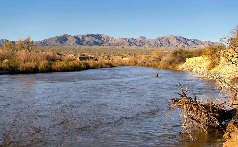
I have two reasons for these monthly jaunts on Arizona roads I’ve never traveled. The first is to give me a reason to get out and shoot. The other purpose is to force me to explore places I haven’t seen, see what’s out there, and see what I haven’t seen.

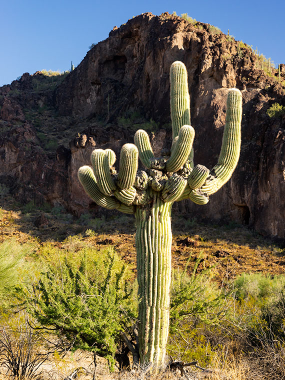
What was new to me on this trip was seeing saguaro growing among the Juniper. Think about it. The mix of those two plants never happens. The saguaro stops growing at about 3000 feet because they don’t tolerate frost. To be in a field of Juniper, you’d have to travel to Sedona, Prescott, or Payson. I yammered on and on about this phenomenon, Anne, as 17 Mile Road twisted up into the Poachie Range. At one point, I was so confused that I stopped and pulled out my Garmin to check the elevation.

Greenwood Peak - One of the two prominent peaks in the Poachie Mountain Range. This one can be seen if you travel through Wikieup.
Greenwood Peak – One of the two prominent peaks in the Poachie Mountain Range. Greenwood Peak can be seen on the western horizon if you travel to Wikieup.

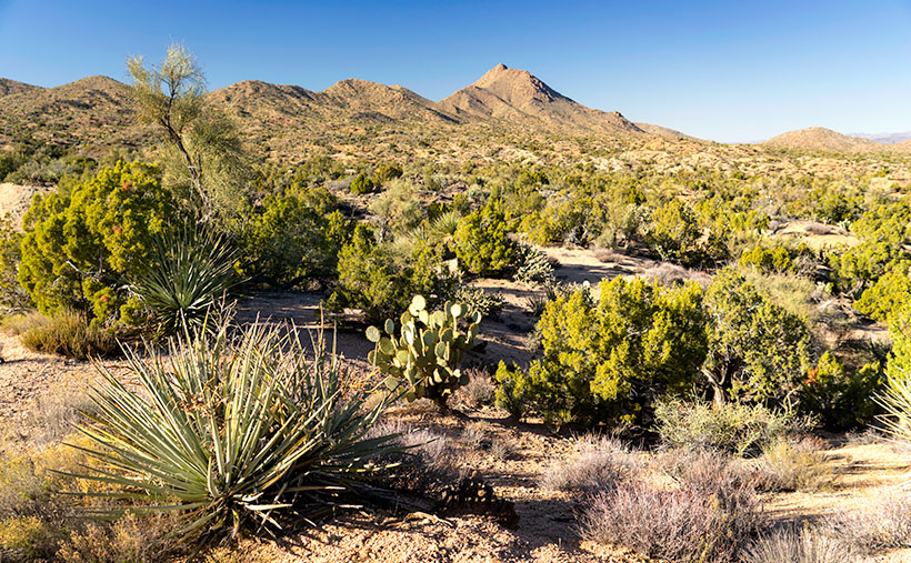
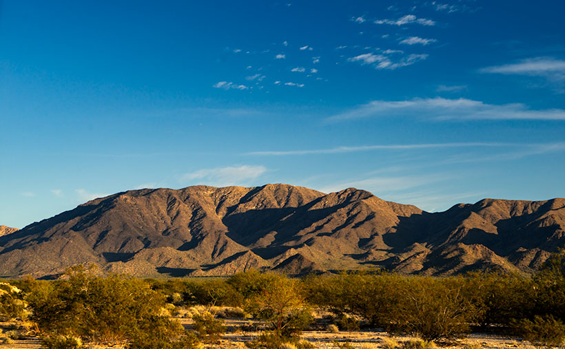
The Poachie Range is 30 miles long, and you see them west of U.S. 93 between Nothing and Wikieup. They’re not very tall, with its tallest peak being Arrastra Mountain at 4807 feet. So, I usually wouldn’t expect to see Juniper this low. When I checked my GPS, the elevation was 3600 Feet. All this leads me to believe that winters aren’t severe here, but more rain falls here than on the desert floors. Anyway, that’s my story, and I’m sticking to it.

The road we traveled crossed the Poachie Range south of its prominent northern peak—Greenwood Peak. It’s the subject of this week’s featured image. It only rises to an altitude of 4300 feet, but it still provides a handsome backdrop for the unusual mixture of cactus and evergreens.

You can see a larger version of Greenwood Peak on its Web Page by clicking here. I hope you enjoy viewing it. Join us next week as we finish our trip to the Harquahala Mountains.

Until next time — jw

Big Wet Sandy Picture of the Week

“I know a shortcut.”

How many of you have heard those words and broken into a cold sweat? The road that Queen Anne and I decided to explore this month didn’t start as a shortcut. It was supposed to be a much longer trip, but it got cut short.

I had intended to drive to the north shore of Alamo Lake. There are a couple of exciting mountains I’ve seen from across the water when I last visited. The best road to get there starts in Wikieup. On my maps (including Google), there are two ways to get there. One is twenty miles south of Wikieup, and the other is about five miles south. Both roads go to the little town of Signal. I’m sure you spotted the signs on a drive to Las Vegas.

We decide to take 17 Mile Drive road. It’s the first left after the Nothing Gas Station. It’s a wide well-graded dirt road that climbs over a pass in the Poachie Mountains, then down into a valley where Signal is. The scenery at the pass is amazing—something we’ll get to later—and you can drive the route with your family station wagon. There’s one hitch along the way, and that’s crossing the Big Sandy River at Greenwood. Usually, crossing the river here could be tricky because—well, it’s deep sand, and you might get stuck without four-wheel drive.

Big Wet Sandy - The normally dry Big Sandy River flowing with water from recent rain.
Big Wet Sandy – The normally dry Big Sandy River was flowing with water from recent rain.

That wasn’t the case today. The Big Sandy was a real river and not in an ugly flash flood kind of way. Its waters flowed like it was an old river; clear and quiet. If I didn’t know better, I might have been tempted to pull out my waders and fly rod and make a few casts. It wouldn’t have been my worst day fishing, being the great angler that I am. There was no way to tell how deep the water was. It could have been two feet or a dozen, but it was not tempting enough for the police to cite me under the Stupid Motorist Law.

So, we’ll begin this month’s journey at the end and go backward. As I said, there was enough material to shoot in the mountains to fill a month, so we’ll save Alamo for another month, and we’ll start at the water’s edge.

I took this week’s featured image standing on the river’s bank. If I didn’t know, I would venture a guess that it was a photo of the Colorado River south of Bullhead City, and the mountains were in Nevada. Nope, it’s all Arizona. We’re looking north-east, and the peaks are actually on our side of the Big Sandy. The high point is Burro Peak. Although everything appears calm on this warm winter afternoon, the banks on each side of the water show erosion from raging water at some time. There are more cliff-banks like this—some higher—along the riverside past Wikieup that you can see from Highway 93. I wonder if I’ll ever again see a sight like this.

You can see a larger version of Big Wet Sandy on its Web Page by clicking here. I hope you enjoy viewing it. Join us next week as we start our return over the Poachie Mountains.

Until next time — jw

Vulture Mountains Film Debut

Have you ever wanted a new tool (toy) so bad that it hurt, and your mother (wife) was a jerk about it? “Please, please, please. I’ll pick up my clothes. I promise to take the garbage out. I’ll eat all of my peas.” Pleading didn’t help. All you got in response was, “You’ll shoot your eye out, kid.” That’s what I endured last year.

I wanted a drone—one of those helicopter things with a camera mounted on it. I’m sure that a lot of people feel they’re a noisy Radio Controlled model airplane only useful for spying on your neighbors. I saw it differently. It’s a camera that can fly, and it would let me shoot places and viewpoints that, because of my age, I can’t get to any longer.

So, I studied them. I learned which ones would support my abilities. I knew their costs, and I harassed Anne for one for Christmas, birthday, anniversary—I had a reason for each occasion. Anne started saying no—even before I uttered a sound.

I lurked on eBay looking for a second hand one, and eventually one came up, so I put a stupid bid on it. You know—an effort that surely wouldn’t win. Days passed with no other bidders, so with shoulders slumped and head bowed, I told Anne what I had done. My stupid offer had won, and now I own a low mileage DJI Inspire 1 v2 with a 4k camera.

I was excited about taking it out and learning how to fly it. Not so fast. The Feds are cracking down on drones. All drones over .55 grams have to be registered, and if I wanted to sell videos, I needed an Operator’s License. I got a registration number for my drone from the FAA, and then my drone sat in the garage for three months while I studied to pass a certification test. I passed the exam in October, and I was free to let my wings soar. Not so fast, now I had to learn how to fly one of these things.

To keep this story short, I’m learning to control my Unmanned Aerial Vehicle (UAV). Because I’m enamored with mountains, I’ve been practicing in the mountains south of town. Filming is a different mindset from shooting a photograph. As a photographer, I can go out and capture an image that I see. With film, you waste your time flying hither and yon. You have to plan your shots. Because mine is an older model, I only get 15 minutes of air time on a battery, so I’m happy to get a minute of footage from each flight. The rest of the time, I spend setting the exposure, flying to and back from my target.

After a couple of months in the field, and over a dozen propellers later, I’m getting the hang of it. I have a long way to go, but that takes time. Now, I’ve collected enough footage to piece together a four and a half minute film that I posted to YouTube. It premièred at midnight last night. How’s that for starting the new year fresh. It is an aerial portrait of the Vulture Mountains, and I call it Vulture Mountains because I’m so clever with titles.

You should be able to watch the clip embedded in this post, but here is the direct link to YouTube (https://www.youtube.com/watch?v=j6ABgBUjldQ). If you bought a new 4k TV for Christmas, that’s the best way to see it. I hope you enjoy watching it.

Until next time — jw

Harquahala Sunset Picture of the Week

Oh my, it’s another Sunday already. It’s the last Sunday of our Harquahala trip, of the month, the year, and the decade. I should have thought of something profound to memorialize this moment. Alas, I’ve been too busy staring at all of these trees to notice a passing forest. I’ll try to do better ten years from now.

For this week’s episode, we’ve turned the corner, literally. Anne and I had been traveling southwest on the Eagle Eye Road, and to continue, we turned right on the Salome Highway, which runs northwest from Buckeye to Salome. At one time, the highway was a detour while they built Interstate 10. Now, both roads are free of traffic. As when we made stops along the way, I pulled off on the broad shoulders, but I didn’t need to. There was no traffic to block, so I could’ve parked in the middle of the road.

As we drove toward Salome (“Where she danced” Dick Wick Hall; one of Arizona’s famous humorist and former Salome resident), the day grew late. The long shadows on the mountain began to look like a minimalist graphic in the style of an Ivan Earl painting, or a Scotty Mitchell pastel. So, I searched for a spot where I could take a picture of the mountain behind a sea of creosote. I found such a place near a large ranch. So I got a chance to shoot this image with and without buildings in the distance. I preferred this version, and I called it Harquahala Sunset.

Harquahala Sunset - With the deep shadows and minimalist styling, this photo reminds me of the style of some artists that I admire.
Harquahala Sunset – With the deep shadows and minimalist styling, this photo reminds me of the style of some artists that I admire.

The part about “without buildings” is a lie. As I processed this picture, I combed through it, looking for dust spots—a regular part of my routine. That’s when I discovered the ruins of the 1930s solar observatory. At the top of the highest center peak is a white tower and utility building. They’re abandoned now, but a few miles behind us, there’s a ten-mile road that goes to the mountain’s top. It’s a challenge that is too much for Archie, but I’d like to take that trip someday.

You can see a larger version of Harquahala Sunset on its Web Page by clicking here. I hope you enjoy viewing it. Next week, we’ll be talking about a new back-road trip somewhere in Arizona.

Until next time — jw