Road Bend Picture of the Week

Although I’ve tried my best to hold back time, the season has changed,  and it’s summer again in the desert. Summer’s dog days are the worst time to be photographing our arid home. Except for the brief respite at either end of the day, the bright sun and ozone combine to wash the colors away. It’s like seeing the world through a 2% milk bottle—the glass ones, not the cartons. You need polarizing sunglasses to force the blue to show in the sky again.

We desert-rats are nothing if not adaptive. Like all of the other Sonoran critters, we hide in our holes during the day. For example, the Round-tailed Ground Squirrel escapes the day heat in his den by sleeping splayed-out on his back. I do the same thing, and I’d show you photographic evidence except I’d be banned forever from the Internet. The other thing we do is migrate. Even during this pandemic, Highway U.S. 93 was a parade of boats heading north towards the rivers and lakes on this holiday weekend.

When we were deciding on a project for July, Queen Anne and I followed a similar logic. We looked for someplace cooler—trust me, 90º is cooler than 110º. We scoured our maps for a place nearby in the mountains, a location that wouldn’t have crowds yet be accessible. We settled on the Senator Highway that runs from Prescott south into the Bradshaw Mountains.
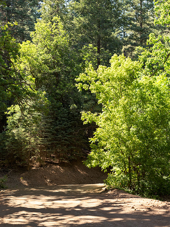
Road Bend - Bright yellow-leaved deciduous trees obscure what's beyond the road on the Senator Highway south of Prescott, Arizona.
Road Bend – Bright yellow-leaved deciduous trees obscure what’s beyond the road on the Senator Highway south of Prescott, Arizona.

Until this month, I didn’t know why there was a dirt road called the Senator Highway. I imagined that it was a route that our state assemblymen traveled when Arizona’s capital swapped several times between Prescott and Phoenix—foolish me. Instead, it’s just another mine road that the miners built it to transport ore and supplies between the Senator Mine and Prescott. If you’re skilled at navigating the Bradshaws, you can technically get to Congress via the Senator Highway.

I find the pine-covered mountains, like the Bradshaw’s, hard to shoot. The trees get in the way. I mean, how many different ways can you get an image of ponderosa pine tree bark? I hunt for edges—splashes of color, an opening to the horizon, or building ruins. That’s what I’m showing in this week’s featured image. At a bend on the highway, I saw some trees (I believe Arizona Ash) with bright yellow-green leaves shinning in the sun against the duller blue-green evergreens. I liked how they obscured the path. My mind wants to find out what’s beyond. It’s a classic leading-line perspective trick, and I find the dappled shade on the road a bonus. I named the first image for our July project Road Bend because it’s a simple title for a simple photo.

You can see a larger version of Road Bend on its Web Page by clicking here. I hope you like it. Be sure to come back next week when we present another image from the Senator Highway outside of Prescott.

Until next time — jw

New Drone Film – The Weaver Mountains The third film in my ongoing series of Arizona Desert Mountain Ranges

I have some excellent news this morning. I posted my third YouTube Video, and it’s ready for you to watch. I admit that in these troubling times, my films are little more than eye-candy, but I’m hoping they give you something nice to watch on TV for a change of pace.

The video is the third in my desert mountain series, and this episode features the Weaver Mountain Range. Those are the mountains that I see every day from my front porch, so in these times of stay-at-home orders, they were a convenient subject.

The reason that I’m producing these films is two-fold. When I look on the net for background on my weekly blog posts, I usually only find a two-paragraph entry in Wikipedia, and if I’m lucky, it may have a photograph or two (usually of historic value). I’m trying to capture these mountains in the ‘now’—a specific season and year—so viewers can see their aesthetic beauty as I do. I’m trying to fill the void of context that these lower ranges are missing. My other reason for these projects is purely selfish. Queen Anne said I could have a drone if it got me out of the house and left her alone. Done and done!

You can view this seven-minute film in several ways. The easiest is to click on the embedded link here in the post above. Or you can see it on your computer by typing this link in your address bar: (https://youtu.be/09knCZ9HY4c). And finally—and I think the best—is to watch it on your smart 4K TV by going to YouTube and search for Jim Witkowski (there are several, but I’m the old guy in the baseball cap). Then, navigate to my Arizona Desert Mountains channel. I hope you enjoy seeing it. Please consider sharing it with your friends and family and clicking on the thumbs-up icon (like-button).

Until next time — jw

Kirkland Junction Picture of the Week

A couple of decades ago, there was a TV ad where a sleepy-eyed baker got out of bed and made his way to his Dunkin Donuts store, and as he made his way, he mumbled, “Time to Make the Doughnuts.” I felt sorry for the poor guy and wished he could crawl back in bed. But, if your business is selling coffee and deep-fried cake to a morning crowd, you gotta’ make some product. You’ve got to work your schedule.

In photography, the quality of light is vital for making memorable images. Pictures that stand apart from the millions posted daily on Instagram. This topic is one that I’ve covered in my writings several times. Any subject looks better when you capture it when the light is warmer, and the shadows are longer—known as the golden hours. Those happen after sunrise when healthy people are still in bed, and before sunset when smart people have sunset cocktails. When I go out on a photo shoot, I try to time my sessions using that light.

The light is even more complicated in Arizona. Because we live in a longitude closer to the equator, that golden hour dramatically shrinks in summers. To further complicate things,  the desert afternoons are too hot for scouting subjects. That’s why I chose the early morning when Fred and I went to Placerita. To get there at the right time, we left before sunrise. Unfortunately, by the time we arrived, the clouds moved in and took away the color, so I made a second trip last week. This time I was on my own because Fred was nursing an old war wound, and Queen Anne doesn’t get out of bed unless there’s a jewelry store involved.

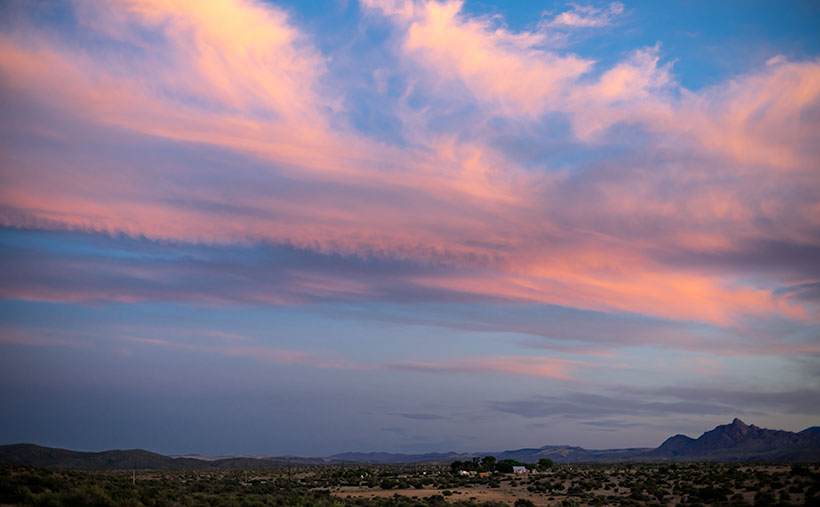
So, in the darkness, I packed my gear into Archie and drove north on State Route 89 with a USB stick full of fresh tunes and a hot mug of coffee in the cupholder. In Yarnell, the sky was bright with a line of clouds leftover from the day before. I watched the color deepen as I passed through Peeples Valley. By the time I arrived at Kirkland Junction, I had to stop so that I could get a shot. After turning onto Wagoner Road—this month’s back road—there was enough light to show color on the ground. I lined up the scene so that some abandoned structures were under the pink clouds.

A set of abandoned buildings at Kirkland Junction underneath beautiful pink clouds.
This week’s photo is of a set of abandoned buildings at Kirkland Junction underneath beautiful pink clouds. The mountain in the background is Kirkland Peak.

That’s how I took the last photo in June’s series. I call this week’s featured image, Kirkland Junction. Interestingly, this month we showed the subject of this month’s journey from the end to the beginning. We began the month at our destination—Placerita-and worked to the road’s start. It’s like that movie Momento.  You knew the protagonist was guilty of the murder right up to the story’s beginning that was at the film’s end. I was so confused by the time the movie was over; I had to think about it for weeks. I hope that I haven’t done that for you.

You can see a larger version of Kirkland Junction on its Web Page by clicking here. I hope you enjoy it. Next week, we’ll begin a new journey on a different, less-traveled highway. I hope you’ll join our expedition.

Until next time — jw

Seal Mountain Picture of the Week

I wouldn’t have made a good prospector if I had lived during the Weaver Mountain mining boom. Since it is Father’s Day, a quote from my dad seems especially appropriate today. “You’re nothing but a lazy bastard, and you will never amount to anything.” Thanks, dad. I’ll cherish those words forever. He’s right, though. I don’t even like to water our flowers much less pick at a mountainside. In last week’s post, I was shocked to see in the photograph of my hand, a callous below my ring. Where did that come from—I haven’t touched a hand tool in decades.

If mining is off my list, what else did men do to earn wages back then? To find out, I continued my exploration of the Weaver Range east side by following the other side-roads near Placerita. This week I drove the Wagoner Road down to the Hassayampa River. I’ve never seen that area, and besides, I might get different scenes for my drone film. I struck pay dirt (sorry for the mining metaphor).

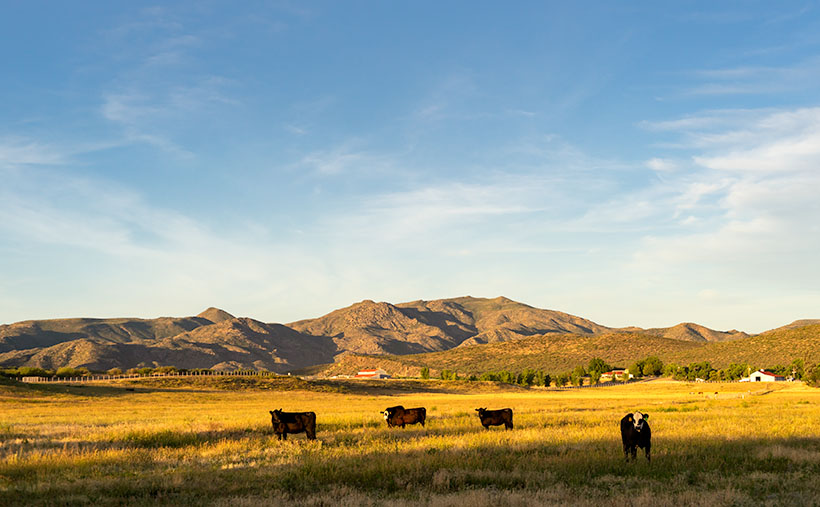
The Wagoner Road descends the east slope of the Weavers into a river valley where the Hassayampa flows above ground. As expected, where there’s surface water, there’s farming—or in this case ranching—big ranches. They’re stacked along the river one after another. They have well-maintained fences, impressive gates, and lots of black cattle (although I did see a herd that had Wagyu markings). The valley reminded me of north Scottsdale when it was mostly Arabian horse farms. It would be an ideal place to live except for grocery shopping. There are only two ways out, the 38-mile road back to Kirkland Junction or crossing over the Bradshaw Mountains on the Senator Highway (Wickenburg is only 20 miles distant in a private aircraft, which is possible given the size of these estates).

Seal Mountain - A remote mountain only seen in an obscure valley is the model that was used on the Arizona emblem.
Seal Mountain – A remote mountain only seen in an obscure valley is the model that was used on the Arizona emblem.

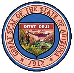
Since I was scouting new views of the Weaver peaks, I found a doozy. It’s the mountain that is in the background of this week’s featured image that I call Seal Mountain. Every Arizonian should know this mountain by heart because it was the model used for the Arizona State Seal. In 1912, who knew it existed? The only place you can see this peak is from the ranches in this remote valley. I’m impressed, however, that my local mountain range is represented on the Arizona seal.

The Arizona Seal - If you squint hard, you can see the similarity.
The Arizona Seal – If you squint hard, you can see the similarity. Personally, I would have chosen Four Peaks.

So, could I have been a rancher instead of working in a mine? MMM—maybe not. That kind of work still involves toiling with shovels, rakes, other hand tools, and even possibly riding a horse. Horses don’t like me. The last one that I road said, “Oof,” when I got on. Let’s take a closer look at that state seal—shouldn’t there be a programmer or a Web designer on it? Come to think of it, there isn’t even a real estate agent, and that’s the number one Arizona job.

You can see a larger version of Seal Mountain on its Web Page by clicking here. I hope you enjoy it. Come back next week to see what else we found along the road to Placerita.

Until next time — jw

Placerita Hills Picture of the Week

While having this morning’s coffee, I sat on the front porch and watched the sunrise over the Weaver Mountains. That’s the best view from my house, but there are still homes and trees in the way, so I can only see their tops unless I walk down to the end of the street. Since the elevation here is 1500’ higher than the Phoenix basin, the mornings are still cool—even in June. Because my porch faces east, all of that pleasantness comes to an abrupt halt the second the sun clears the horizon. Then I’m forced to retreat to the back where I have a spectacular view of my neighbor’s shed.

When we moved here almost five years ago, I knew nothing about the Weaver Range other than their name. With time, I learned more about their secrets as I researched the subjects I photographed. I fear that by the time I run out of film, I’ll become a sort of grizzled old Gabby Hayes wandering the Wickenburg streets, wearing a torn cowboy hat, a mouth full of chaw, and spinning yarns about mountain ghosts, so the tourists will give me loose change.

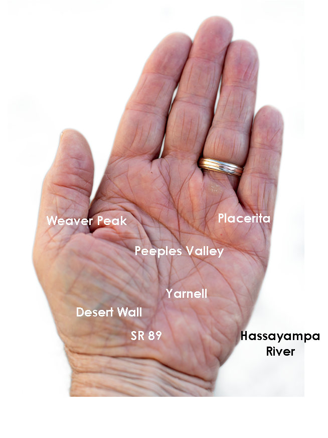
The Weaver’s have been at the center of my attention for a couple of months now because they’re the subject of my third drone video that I’ll finish in a couple of weeks. For the video, I made a list of points to film, and I’ve grappled how to describe the range best. On the way to the Prescott Costco last week, I blurted to Anne, “They’re like a horseshoe wrapped around Peeples Valley.” She said, “Huh?” I probably should have started with some context. Then I came up with a better metaphor. They’re more like the palm of your left hand—not the Michigan one.

The Weaver Range - The geography of the Weaver Range can be summed up on one hand, but you have to use the correct one.
The Weaver Range – The geography of the Weaver Range can be summed up on the one hand, but you have to use the correct one.

Use your imagination. Peeples Valley is the depression in the center, and State Route 89 is your life-line ascending from your wrist up Yarnell Hill to the little town at the pass. The Weaver’s tallest peaks are along with the thumb, and where gated communities of summer homes are. The desert wall (the northern boundary of the Sonoran Desert) is along your wrist. The area under your little finger represents the lower eastern peaks—more like rolling hills. The Hassayampa River separates the Weavers from the Bradshaws. The area that we’re exploring this month is at the base of your little finger.

Placerita Hills - The east flank of the Weaver Range are hills than tall peaks.
Placerita Hills – The east flank of the Weaver Range are hills than tall peaks. On the distant horizon is Weaver Peak which is on the other side of Peeples Valley, and is the range’s tallest peak.

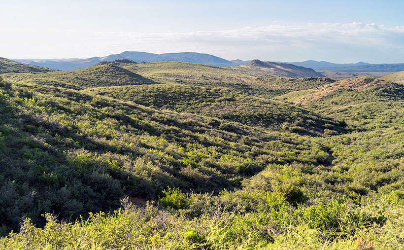
The east flank of the mountain range doesn’t have any soaring peaks, at least not when you drive in from Peeples Valley. The mountains are more like rolling hills, as seen in this week’s featured image that I call Placerita Hills. To get there, you have to drive up a long gradual incline. The hilltops have granite outcrops that are like miniature versions of eastern and southern peaks. In the photo, the dense vegetation is very evident and is a mixture of Manzanita, Scrub Oak, and some others that I’m not able to name. Unlike the desert floor, there’s no space to walk, and it’s easy to understand why cowboys wear chaps. The mule deer that we saw bounced over the brush instead of running through it. It’s incredible to me that the area’s ranchers can raise cattle here.

You can see a larger version of Placerita Hills on its Web Page by clicking here. I hope you enjoy it. Come back next week to see what else we found along the road to Placerita.

Until next time — jw