The Long Way Home: Three Routes, One Corolla, and a Little Adventure Pictures of the Month: California Coastal Towns

“So when the day comes to settle down,
Who’s to blame if you’re not around?
You take the long way home,
Take the long way home.”—Supertramp
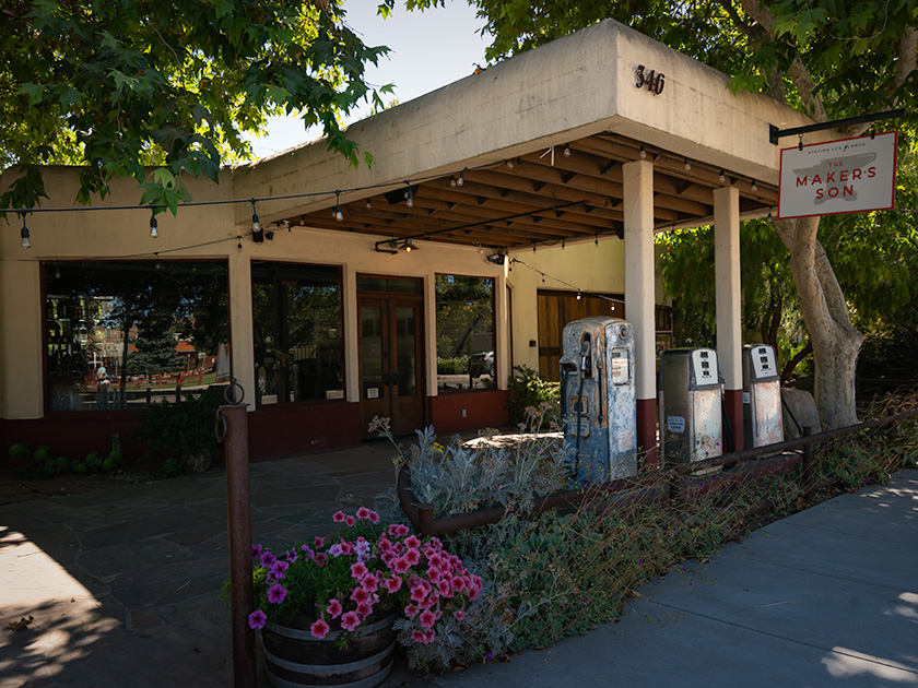
Vintage gas station repurposed as Makers Son venue in Los Alamos, California with rustic charm
Exploring Los Alamos: Makers Son Event Space in a Former Gas Station—The Makers Son, a vintage gas station in Los Alamos, California, now serves as a charming venue for weddings and events.

Like every good fairytale, the good times eventually come to an end. Too soon, we found ourselves facing that tedious drive home. But instead of a simple choice, we had three different ways to go—our own version of ‘The Three Little Piggies.’ Only this time, there were three little routes: the quick and efficient one, the scenic and leisurely one, and the ‘I don’t really want to go home’ route.

The Fast Way (All Freeway—All The Time)

The first little piggy is all about speed—no frills, no fuss. It’s I-5 or US 99 south to Bakersfield, then a quick jog over to I-40 through Barstow, cruising along Route 66 nostalgia until Kingman, and finally, the home stretch to Congress. There is not much scenery, but it’ll get you there faster than you can say. ‘Are we there yet?’ It’s our choice for days when the destination matters more than the journey. This is also our go-to route when we’re in a hurry or carrying precious cargo—like a couple of cases of wine. We can make this trip in about 14 hours, provided I make the necessary stops for Queen Anne’s bathroom breaks.
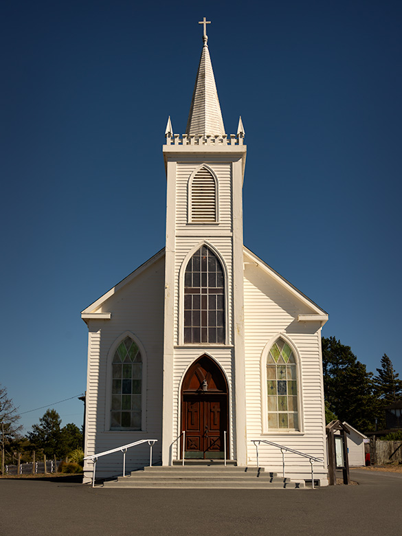
St. Teresa of Avila Church in Bodega, California, iconic landmark photographed by Ansel Adams
St. Teresa of Avila Church in Bodega, California—a spot where Ansel Adams stopped in 1953 when this drive was just a dirt road. Anytime I get within range of an Adams subject, I make it my mission to stop and capture my own take. Queen Anne was more than willing to tag along—Bodega was the filming site for Hitchcock’s The Birds, and she didn’t pass up the chance to channel her inner Tippi Hedren, posing dramatically on the schoolhouse steps nearby.

The Leisurely Way (Santa Paula Route)

The second little piggy prefers a scenic detour. This route winds down California’s Highway 101 through coastal towns and charming spots like San Luis Obispo, Santa Barbara, Santa Paula, and Fillmore. Fillmore holds a particular place for me—it’s where I take a moment to visit my sister’s grave, reminding me that every journey has meaning beyond the miles. And then, with a clearer head, we pick up the drive home.

From there, the road takes us through Los Angeles, where we must be mindful of our timing and stay as far away from downtown as possible. Even in the middle of the night, we expect traffic, but if we time it right—threading the freeways between morning and evening rush hours—we can glide through with minimal stop-and-go. Our preferred route through LA is the I-210, which runs along the base of the San Gabriel Mountains and offers a spectacular view…on the one day a year when they’re actually visible through the smog.”
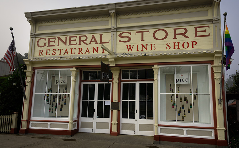
Pico Wine Tasting and Restaurant in a historic general store building in Los Alamos, California
Pico Wine Shop and Restaurant in Los Alamos: A Culinary Landmark – Pico, a historic general store turned wine-tasting venue and restaurant in Los Alamos, California, offers a high-end culinary experience.

The “I Don’t Really Want to Go Home” Way

And then there’s the third little piggy, the route for when you’re in no rush. This path hugs the coast down the Pacific Coast Highway, SR1, taking the long, winding road past Big Sur, through postcard-perfect towns, and across landscapes that demand photo stops every few miles. It’s the scenic route to end all scenic routes—a journey for those who want to stretch the fairytale a little bit longer.

Once we reach San Luis Obispo, we merge onto the 101 until Ventura. From Oxnard to Santa Monica, we’re back on the PCH with plenty of chances to spot a pod of dolphins, a whale, or seals if we’re lucky and observant. Since we have all the time in the world, we make it a point to stop, walk all the piers, and grab a bite at a couple of seafood shacks along the way.

When it’s time to leave Santa Monica, we jump on I-10 straight into the city’s heart-stopping freeway traffic. But instead of fighting it, we go with the flow—windows down, wind in our faces, and Randy Newman’s ‘I Love L.A.‘ blaring on the stereo. For a moment, we’re part of the LA rhythm, dodging in and out of lanes with all the other dreamers. Eventually, US 60 guides us through Riverside and into the wide-open desert, where the road stretches out, and the only traffic is the tumbleweeds. If done correctly, we measure our progress in miles per week.

A Corolla with Attitude

The real surprise on this trip was discovering our trusty Corolla IM’s hidden ‘Sport’ mode button. I’ve dubbed it the ‘Gutless Wonder,’ but with Sport mode engaged, it gave me more spirit than expected. The button sharpened the transmission shifts and tightened the power steering, making each corner feel just right. For a moment, I almost felt like I was driving an old British sports car—minus the manual gearbox and with the comfort of roll-up windows and a top. And thanks to the IM’s independent rear suspension, it didn’t just handle the winding roads—it made them fun. Who knew our little econobox had it in her?
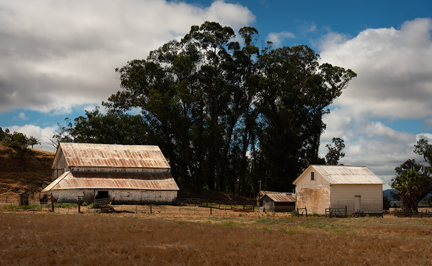
Rustic white barns in a scenic countryside landscape on the road from Sonoma to Calaveras, California
Historic White Barns: A Serene Stop Near Highway 101 – A pair of white barns along the scenic Sonoma to Calaveras route, capturing the rustic charm of California’s countryside.

Our Extended Fairytale Ending

Since it was still August and we weren’t in a hurry to get back to our cottage at the base of the Weaver Mountains, we opted for the middle route with a twist: four days, with overnight stops in places we’d never explored. Our usual all-day ‘Bataan March’ became a leisurely four-day journey of discovery, and—true to form—Anne and I conveniently planned our stops around California’s Central Coast wine regions. Now, we have at least four new destinations for future trips.

Each route home has its own quirks and charms, but this time, taking the scenic way back reminded me that the journey can be as memorable as the destination. Sometimes, the right choice isn’t the fastest or most convenient—it’s the one that lets you hold on to the experience just a little longer.

Till next time, keep your spirits high and your humor dry.
jw


BTW, 2024 Wall Calendar Orders are Open!

It’s that time of year again—calendar season! If you’d like to grab one of my personal wall calendars for 2024, now’s the time to let me know. The calendars are 8.5 x 10 inches, spiral-bound, and printed on high-quality card stock, perfect for showcasing a year’s worth of my favorite shots.

A heads-up on pricing: VistaPrint’s prices are always high initially, but they usually offer great discounts as the holidays approach. Last year, they dropped to around $11 plus shipping after Thanksgiving, but they could be as high as $20 if I go by their price list today. Whatever my printing and shipping costs are, that’s what I charge—no markup.

If you’re interested, please let me know by November 15. That way, I can organize everything, and we can take advantage of post-Thanksgiving sales! Delivery is usually at the beginning of December, so they make great stocking stuffers.

Tom Reed Mine and Elephant’s Tooth Picture of the Week

After publishing last week’s post, I lingered in my office for a while with a nagging question. It was more of a puzzle than a burning issue, but it would persist until I solved it. My enigma was this: If Lt. Whipple completed his survey in 1854, and the railroads were already following his trail, why in 1926 did the Highway Department run Route 66 through a rugged mountain pass when they established the National Highway system? Wouldn’t it be faster and cheaper to follow the railroad tracks down to the Colorado River? I used up over half of my monthly Google query allotment trying to understand their logic. After distilling some facts that I uncovered, and with some fantasy time travel, I concluded that the department wanted travelers to go through the shining city on the hill—Oatman. When the mines were still open, Oatman was a bustling city, with a good hotel, restaurants, bars, groceries, and gas stations.

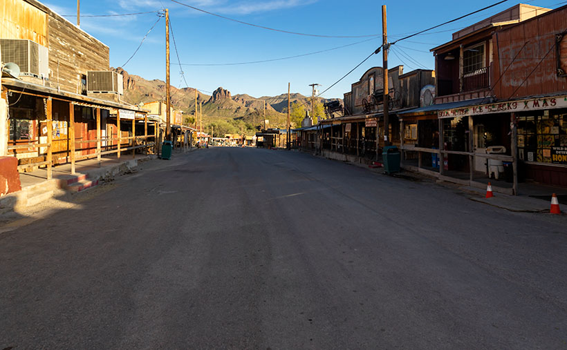
Oatman Main Street 2020 - The crowds of tourists are gone, the stores are shuttered, and even the burros are social distancing.
Oatman Main Street 2020 – The crowds of tourists are gone, the stores are shuttered, and even the donkeys are social distancing.

Arizona has two types of ghost towns, and to paraphrase a line from Frank Zappa’s song Camarillo Brillo, there are real ghost towns, and there are Walmart ghost towns. Real ones are scattered throughout Arizona’s mountains and plains. Places like Cochran, Cherry, and Ruby. If you drive there in your Jeep, you’d be lucky to find a standing building, but—most of the time—only their crumbling foundations remain. As for the latter towns, they’re thriving communities. Arizona’s big four include Jerome, Tombstone, Bisbee, and Oatman. People still live there, and more importantly, tourists visit by the busload. They come to drink in the saloons, eat lunch in the bordellos, watch the fake gunfights, ride oar carts into the mine shafts, and feed the wild donkeys. I wouldn’t be surprised to learn that these towns generate more annual revenue today than the mines ever did.

Before my first Oatman visit, I already knew the image that I wanted to take. Ansel Adams—the photographer that most inspired me—had already made it. Mr. Adams must have blackmailed God because he had Him move heaven and earth into compositions that no other mortal photographer ever saw. The photo that I’m referring to is in one of his books and is called Tom Reed Mine, near Oatman, Arizona. It shows a cluster of buildings on enormous washtubs with a pinnacle in the background. When I was younger, I tried to visit the places he captured so I could see what motivated him. That was my way of learning from a master. But in all my visits, I never found those impressive mine structures.

When Queen Anne and I made our Route 66 journey last month, snapping pictures in Oatman was the last thing I wanted. We were avoiding people, so stopping in a crowded tourist trap was out of the question. But when we arrived, the streets were empty of people wearing funny hats, loud shirts, sandals with black socks, and speaking in foreign tongues. The merchants had shuttered the windows, and even the wild burros—the stars of the Oatman experience—were social distancing. I had to stop and document this weird moment—Oatman had turned into a real ghost town.

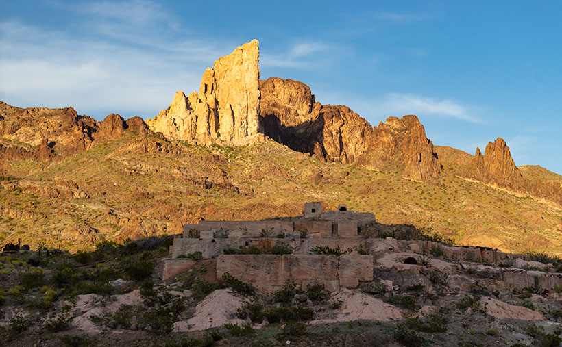
Tom Reed Mine and Elephants Tooth - The concrete foundations are all that remain of the magnificent structures that Ansel Adams photographed.
Tom Reed Mine and Elephants Tooth – The concrete foundations are all that remain of the magnificent structures that Ansel Adams photographed.

As we drove out of town through the south side, the sun was low in the sky and casting lots of color on the hills—including the pinnacle that Adams captured. I stopped on the road where some concrete foundations lined up below the white outcrop—that I now know is called Elephant’s Tooth—and took this week’s featured image. I call it Tom Reed Mine and Elephant’s Tooth. We spent less than 15 minutes at that location before driving on.

Since we’ve been home, I was curious about the Adams photo, so I got it down from the bookcase and searched for his rendition. I wanted to see the buildings that he shot again. I’ve never been able to find them no matter how much I scoured the town. Upon examining his image, I realized that he took that photo in 1952, and people have since torn down the structures. The only trace of their existence is the concrete terraces in my picture. When I took my photo, I stood within ten feet of where Ansel Adams worked his magic, and we were both inspired by the same subject. I was so close to being in the presence of greatness—I only missed him by 68 years. My life can go on now.

You can see a larger version of Tom Reed Mine and Elephant’s Tooth on its Web Page by clicking here. I hope you enjoy it. Next week, we’ll pass by the Warm Springs Wilderness on our way to the Colorado River. I hope you’ll join us then.

Until next time — jw

Stanton Dusk Picture of the Week

On my last outing, I spent an afternoon exploring the Stanton Road searching for suitable photography subjects. The dirt road runs along the base of the Weaver range between Arizona Highway 89 and the Stanton ghost town. There, you can either continue up the hill on the back road to Yarnell—something that I’ll do in the future—or take the Octave road to the old Octave Mine site. I drove down the road until it became too rough for my wimpy truck and I turned around. The light was failing anyway, so I decided to call it a day. I was almost back to Stanton, and as I rounded a corner, I saw this scene and stopped the truck so I could take a photo. I call this shot Stanton Dusk and it’s my new photo of the week.

Stanton Dusk
Stanton Dusk – The sun at the western horizon lights the ridges along the Weaver Range behind the ghost town of Stanton.

The low sun lighting the mountain ridges is what first caught my attention. The ridgelines highlighted like that keeps Weaver Mountain from being a flat silhouette and adds texture and perspective to the large dark shape. I think the sky and clouds contribute to a sense of open space. Finally, the light-colored structures atop the lower ridge anchor the frame. This shot has many of the elements that Ansel Adams captured in his masterpiece: Moonrise over Hernandez (I must mention that the image in this link is a poor representation of one of his original prints). I’m not saying that my shot has the stature of his, but Moonrise has long been a personal inspiration and I can see some of the influences in my shot. Of course, my shot doesn’t have a moon and—as some photographers do—I could add one in post-processing, but I won’t.

You can see a larger version of Stanton Dusk on my Website here. Examine both pieces and see if you agree with me. Can you see the similarity in the dark sky, the light structures, background mountain, and clouds, or am I fantasizing? Please feel free to share your thoughts in the comment section below and don’t be bashful about clicking on the Like button if you enjoyed this post.

Until next time — jw