The weather here in Congress has been variable. I remember writing last year about the lack of rain, and we haven’t had that this year. It seemed like a new front moved through each week with more precipitation. The winter’s highlight, however, was last week’s snowstorm. There was enough of the white stuff covering our yard that we could measure it with a ruler (inch and a half). We’ve woken to frost and snow before, but this time it came down in the afternoon with temperatures well above freezing. Snow covered the surrounding mountains for days, and it looked more like Colorado than the desert.
During this time, I was trying to find a place for this month’s images, and I decided to stay at home this month and feature Congress. It’s been a while since we’ve done that, and besides, I need to cut down on my gas bill anyway.
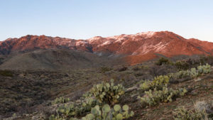
This week’s featured image helped me decide to stay local. I wanted to show you how pretty the snow was on Weaver Peak, so for days, I waited for the sky to settle so I could shoot the scene without slogging through mud. Three days passed before those conditions were met and I was able to capture this image. I waited for the last rays of the sun, so that gives it that red glow. I call this image Weaver Snow, and I hope you enjoy it. For me, it shows one of the reasons that Queen Anne and I moved to the sticks.
You can see a larger version of Weaver Snow on its Web Page by clicking here. I hope you enjoy viewing this week’s post and next week; we’ll show another featured image from Congress.
Until next time — jw