Dune Moon Picture of the Week

When Queen Anne and I make our quarterly medical run-to-the-border, the drive is usually three-hours each way. Most of the time, we leave at dawn, see our dentist, buy prescriptions, and then come home. For me, those are long days behind the wheel; for Anne, not so much. She’s usually asleep in the passenger seat until her snoring wakes her up.

Occasionally when we have lab work done, or the customs line is three-hours long because the snow-birds have arrived, we’ll get a room in the elegant east-side Motel 6 and dine at the swanky four-star Denney’s. Our December visit was one of those occasions. Since I needed a topic for January’s posts anyway, we spent an extra night and took a circuitous route home—we’d go up to Blyth to work the Algodones Sand Dunes for this month’s project.

The great swath of sand starts about three miles south of the border outside of Los Algodones, Baja. It continues 45 miles northwest into the Coachella Valley (California’s Imperial Valley). They’re the most extensive contiguous dune system in the U.S. The dunes are also called the Imperial Dunes, Glamis Dunes, and Gordon’s Well. The name varies with location and the leisure activity you’re doing. Still, the entire system is officially named Algodones Dunes (in Spanish, it means cotton plant—the predominant crop grown on both sides of the border along the Colorado River). This week, we’ll start west of Yuma at the Mexican border—at Gordon’s Well.

Imagine it’s 1850, and you’ve traveled by wagon hundreds of miles across the scorching Sonoran Desert, forded a raging Colorado River, and finally crossed into California. You’d think your hardships are behind, but then, you’re greeted with 6 miles of Sahara-like sand to cross. With each step, you sink up to your knees. Even in 1926, when the nation’s first Ocean to Ocean highway was built (U.S. Route 80), the shifting sand was an engineering nightmare. They couldn’t simply scrape the sand away because the prevailing wind constantly covered it up again. Even today, if you’re caught in a windstorm along this section of road, you’ll risk a chance that the sand will blast the paint off your car.

Plank Road - You can see what's left of the old plank road on display at Gordon's Well.
Plank Road – You can see what’s left of the old plank road on display at Gordon’s Well.

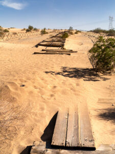
The road builder’s solution for getting across was to build a plank road—movable wood sections on railroad-lie ties that floated on the sand’s top. It turned out to be challenging to maintain, but it drastically cut the crossing time when it was clear. Eventually, the planks were replaced with new and expensive asphalt, and eventually, it became Interstate 8. There is a section of the original plank road at Gordon’s Well on display. When you grow tired of looking at the old wood road, you can walk over to the border wall and lean on it.

Dune Moon - A waning gibbons moon setting over the Algodones Dunes west of Winterhaven, California.
Dune Moon – A waning gibbons moon sets over the Algodones Dunes west of Winterhaven, California.

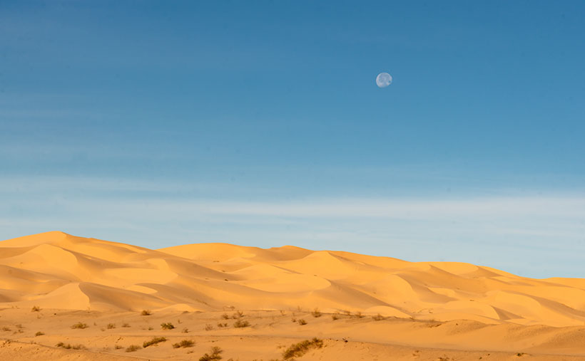
As Anne and I drove west on the freeway, we spotted a waning moon setting on the dunes, so we looked for a place to stop. We’ve got stuck in these sands once before, so we were careful not to drive off the blacktop. I didn’t want to pay for another hook to come to yank us out. As you can see, we found a good spot and took this week’s picture called Dune Moon. The name could have been funnier if I had shot it during a particular summer month. Se la vie.

You can see a larger version of Dune Moon on its Web Page by clicking here. Next week we drive north up the Imperial Valley to visit the northern dune crossing. Be sure to come back and see what we found.

Until next time — jw

Snow Canyon—The Book      New book announcement

Do you remember from my first of this month’s post—Stacked Arches—where I said, “There’s enough to photograph within the park’s boundaries to fill a small picture book?” Well, there is—and I have—so I did. This short particular midweek post announces my latest book—Snow Canyon.

Snow Canyon - The Book - my latest book will be released next week, but you can get a sneak peak by clicking here.
Snow Canyon – The Book – my latest book will be released next week, but you can get a sneak peek by clicking here.

They haven’t released it yet; that will happen sometime next week on Amazon. It’s available in two versions. The first is a hardcover with a dust jacket. The paper I used was the best offered, so I expect the photos reproduction to be outstanding. The second variation has a soft cover and is printed on upgraded paper stock.

It’s a self-published book, like my others, so, unfortunately, its cost is prohibitive—unless you want to buy 100 copies or more. However, I wanted you—my subscribers—to enjoy it, so I’m providing a link to a free version in PDF format as a way of saying thanks for hanging out with me.

Once you download the PDF (2MB), you can read it, print it, tape it to your fridge, or line your parrot cage. It’s yours to do as you wish. Get your copy by clicking on the cover shot above or on this link: Snow Canyon—The Book.

I hope your New Years’ celebration is safe and sane. I’d like you to be around next year when we go to many exciting new places.

Now, we will return to our regularly scheduled programming.

Until next time — jw

Lava Grass  Picture of the Week

Christmas, along with the rest of the solstice holidays, is almost over. I hope that Santa brought you something better than the lump of coal I got. Queen Anne is on the couch in her bathrobe and tiara with a box of Kleenex. She’ll be useless until Amazon Prime stops showing Christmas movies. Since we won’t be back before then, we’d like to wish you the best New Year in 2022. Things have got to turn around eventually, so let’s give it a go one more time.

Today, I will finish up the year, and our visit to Snow Canyon State Park by talking about the other rock found there—basalt from recent lava flows. If wind, water, and ice sculpt sandstone, the cooled magma is geology’s Etch-a-Sketch reset button. The black rock covers the softer sandstone and forces water to change course. The runoff carves different canyons, like in the park.

As you explore the park’s north side, you’ll see basalt-covered cliffs. They used to be the canyon floor, but 27,000 years ago, the lava forced the drainage west and carved a new floor—now a couple of hundred feet lower. Snow Canyon has a couple of trails that wander through the jagged black rocks; the Lava Tube and the Cinder Cone trails. The latter is interesting because you can hike to the cone’s rim and look into the extinct caldera. However, the track is uphill, and on the east side of State Route 18, so we skipped it.

Lava Tube - When the magma skin cools and then ruptures, the flowing magma escapes leaving behind a cave.
Lava Tube – When the magma skin cools and then ruptures, the flowing magma escapes leaving behind a cave.

The Lava Tube Trail is shorter,  level, and leads to two lava tubes—which are places where the hardened surface fractures releasing the still molten magma inside to flow away. The remaining caves are sometimes big enough that you can crawl into and see where the bats and spiders live—I’ll pass. The above photo is the smaller tube, and visitors— braver than I—crawl into it.

Lava Grass - A small tuft of grass ekes out a living in barren basalt.
Lava Grass – A small tuft of grass ekes a living in barren basalt.

I find basalt a challenging subject to photograph. It’s like taking a picture of a black cat in a coal mine. To get any detail, you need to over-expose, which washes out the rich depth. Fortunately, and is the case with this week’s picture that I call Lava Grass, there’s enough green lichen growing on the rock to prevent the shadows from completely blocking up.

I feel lucky to have spotted the tuft of dried grass surviving in the barren rock. I concentrated hard on staying upright as I hiked the trail in the early morning. The jagged basalt is not skin-friendly and will likely draw blood if you fall on it. And—silly me—I left my bicycle helmet at home.

You can see a larger version of Lava Grass on its Web Page by clicking here. Next week we start a new year, with a new project in a new location. Be sure to come back and see where the road takes us.

Until next time — jw

Cup Holders Picture of the Week

I will pause our Snow Canyon State Park tour for a couple of paragraphs so we can run over to the coast. Don’t worry; we won’t have to put up with any of those weird Californians. Where we’re going, they don’t exist yet. We’re not traveling far—maybe a foot or two. However, we are breaking every law in physics to travel back one-hundred-eight million years ago—to the Jurassic era. You can turn around now and take in the Sundance Sea, right here in southern Utah (how old is Robert Redford anyway). Don’t go in the water. Big things in there will eat you like you’re a gummy bear.

Turn back this way and look down the shoreline. Massive dunes—hundreds of feet high—go on for hundreds of miles. Until now, it’s been hot and dry here along the Equator, but the climate is changing. It’s becoming muggier and swamp-like. The oceans are rising, and soon (in geological time), the water will cover the sand and pile more sediment. The pressure on the dunes will bind them into stone—never to be seen again.

Things would have stayed that way, except our stupid captain rammed the North American plate into the Pacific Plate, and there goes the neighborhood. The crash spun us around and raised the Rockies, the Sierra Nevada, and all the other little wrinkles in between. The resulting damage cracked the mantle so badly that volcanoes could form, raising the Colorado Plateau. Then the Californians move in—can it get any worse?

The crash shoved our peaceful little seaside village up a hillside. We no longer live in a basin where sediments collect. Now, our water flows to a place far away. It peels back layers of rock—like an onion when it does. After erosion uncovers parts of the great dunes, we’ll see them again here in St. George, Zion, and north of Escalante. Now they’re as hard as a rock.

Dune Walkers - About the only way you can stay on the Petrified Dune Trail is to go on a guided hike, like these people.
Dune Walkers—The only way to stay on the Petrified Dune Trail is to go on a guided hike like these eight people.

You can snap out of it now and return to reality, where we’re standing on the Petrified Dunes Trail. Because it’s all rock, the only clue you have to follow is the path worn smooth from countless boots. It’s easy to leave it, but that’s fine because you won’t damage anything. The rock grips like sandpaper, making it easy to scramble up and down the slopes. As you wander across the uniformly fractured rock, you examine the exceptions.

Cup Holders - Freezing water bores into the sand stone and will over time reduce the rock to sand grains.
Cup Holders – Freezing water bores into the sandstone and reducing the rock to sand grains over time.

That’s how I found this week’s picture. The round wells in the picture are places where water is collected and has a chance to freeze. As the ice expanded, it fractured the sandstone and chipped it. These spots get deeper; they’ll hold more water and bore into the stone faster. Eventually, they’ll be so deep that they’ll split the block until it reverts to sand grains. I think the shapes of the cups are fantastic, but I like the rich and varied colors in the stone. When you look closely at this, sandstone has a lot of depth and texture.

Click here to see a larger version of Cup Holders on its Web Page. Come back next week when I’ll tell you about how the stupid captain left the kettle on too long and spilled hot lava all over the park.

Until next time — jw

Arch and Honeycomb Weathering Picture of the Week

When you were a child and thunder was new to you, did your mother try to console you by explaining that the noise was just God and the angels bowling in heaven? My mom did that. I believed her because she’d never lie to me, and she knew I’d catch her (although I don’t understand why Santa stopped sending me $20 at Christmas when she died). She always told people that I was their peer, although there may be more intelligent children. Well, what her exact words were is, “He sure ain’t the brightest kid in the class.”

Arch and Honeycomb Weathering - inside the cave on the Jenny's Canyon Trail are a natural window and Honeycomb Weathering.
Arch and Honeycomb Weathering -Inside the cave at the end of Jenny’s Canyon Trail are a natural window and Honeycomb Weathering.

This memory comes to mind because I think I’ve captured the scoreboard that the angels used. It’s visible in this week’s picture—the rows of distorted cribbage holes. If one of the bowlers threw a strike, a lightning bolt would cause a tree to burst into flames. Then they’d advance their marker into the next hole. The one that got their rock in the last spot won. It’s that simple.

I did a lot of online research to prove my thesis, but I found nothing. Instead, the experts call this kind of erosion honeycomb weathering. It’s not clearly understood, but it’s an alchemy of rock, salt, rain, freezing, and expansion. You also have to hold your tongue just right while you’re making it. I saw this type of erosion before in Canyonlands National Park when we visited too long ago, so I assume that it’s shared across Southern Utah’s sandstone formations.

This example of honeycomb weathering is in Utah’s Snow Canyon in a place they call Jenny’s Canyon. It’s at the end of a half-mile (round trip) trail near the park’s south entrance, and it was the shortest and the most rewarding of the side trips that we took. The trail leads to a slot canyon in the sandstone, but not the usual slot. Unlike Antelope Canyon near Page—where running water has cut a course into the sandstone—this is one of those stacked dunes (see last week’s picture) with a gap between the layers. Jenny’s Canyon begins as a typical slot, but dead ends in a short cave. I took my shot from inside the cave.

If you think some weird bacteria are growing on the cave walls, let me explain the color. Like wearing a pair of rose-colored glasses, when the sunlight bounces off the red sandstone, it adds that color to the reflected light, and that’s why the back wall seems to glow orange. Other photographers have successfully captured this phenomenon at Bryce Canyon, but I’ve been unlucky so far. “Damn you, Bryce. I’ll get you one day.”

Jenny's Canyon Sky - Because the canyon walls almost touch, the view of the sky is a narrow ribbon in Jenny's Canyon.
Jenny’s Canyon Sky – Because the canyon walls almost touch, the view of the sky is a narrow ribbon in Jenny’s Canyon.

The second image that I included to illustrate my post is the sky from Jenny’s slot canyon. I’ve seen photos like this, and I wanted one of my own. I think the blue against the glowing orange and dark walls look like torn craft paper glued on one another as a collage. I consider it an abstract because it has no story of its own.

You can see a larger version of Arch and Honeycomb Weathering on its Web Page by clicking here. Come back next week to see the next trail that we explored. It’s not far up the road.

Until next time — jw