Two days have passed since April Fool’s day on Friday. That morning, Queen Anne stopped by my office door and announced, “I’m pregnant.” She’s a one-trick pony because she’s recycled that joke every year that we’ve been married, so I ignored her. However, Friday was an important milestone for me, and since I’ve waited two days, you know I’m not pulling your leg. Friday marks the 50th year since I moved to Arizona. I think that officially makes me overqualified to be a native.
With the month’s change, we’re starting a new project. April Fool’s—we’re not leaving Willcox. I’m just going to show you why we actually traveled to Cochise County and what we did with our afternoons. You’ll recall that I spent mornings in Willcox searching for a decent cup of coffee and shooting the town’s historic buildings. After an hour or so—when the light became too harsh—when I returned to our motel and opened the door, Queen Anne sat on the bed corner bejeweled and makeup finished. “I’m ready for breakfast,” she’d say—who am I kidding? That would never happen. The truth is that I could hear her lyrical voice waft from the bathroom, “I’ll be ready in a minute.” In husband-speak, that phrase meant that I had time for a nap.
The actual purpose of our Willcox visit was to photograph the Chiricahua National Monument. After fifty years of living in Arizona, this was my first visit. It’s usually a half-hour drive southeast of Willcox. Still, we dawdled with a camera and stretched the trip to over an hour. The scenery along County Road 186 reminded me of California’s central valley and the Sierra Nevada foothills. Long butterscotch colored grass filled the broad Sulphur Springs Valley between the Dos Cabezas Mountains (Two Heads in English) on our east to the Dragoons on our west. Arizona ranges don’t tower over its valleys as the Sierra’s do, but at least the air was clear, and we could see all of the mountains.

On one of the many photo stops that we made, I was able to chat with the local postal carrier and got some great news. He told me that I don’t have to be useless after my death because I can always get a job delivering mail for eternity. You saw my after-life job delivering mail if you watched Funny Farm—the movie. All I have to do to qualify is pass the Civil Service Exam.
The route coming out of Willcox ends at the Junction of county roads 186 and 181, and you turn east on the latter. You pass from open range into a canyon as you head into the Chiricahuas. Within four miles, there’s a pay station. It’s closed due to the pandemic, so the Rangers collect any fees at the visitor’s center. Immediately on the right is a small family cemetery where the Erickson’s rest under shady oak trees. The Erickson’s are the family that homesteaded here after he retired from the Army at Fort Bowie. They established a ranch along Bonita Creek called Faraway Ranch because it’s far away from anything. Their daughter, Lillian, and her husband, Ed Riggs, welcomed guests to the homestead to promote tourism. They built many of the trails still in use, allowing visitors to wander among the unusual columns of eroded stone.
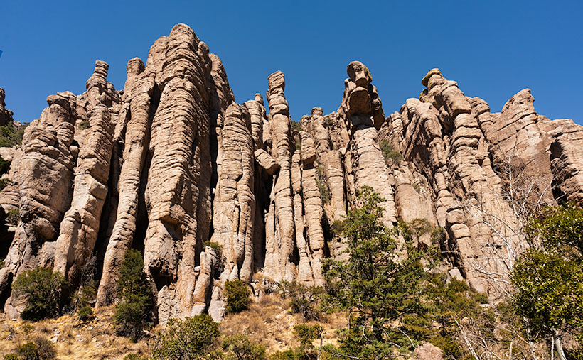
There’s only a single road in the monument that runs from the entrance, past the visitor’s center, climbs through Bonita Creek Canyon, and winds along the ridge of the park’s eastern boundary. Along its length, there are numerous stops, pull-outs, and parking areas where you can stop and take in the view, like this week’s picture that I call Organ Pipes. However, if you want to immerse yourself in the complete gestalt, you should plan on hiking one of the trails. They range from a half-mile to a couple of miles long. You can also link several trails and make your feet suffer to your heat’s delight.
Chiricahua National Monument only has one small campground, which fills quickly—especially during the season. There are only two towns with hotels, Willcox along Interstate 10 and Douglas at the Mexican border if you’re willing to drive further.
The Organ Pipe Formation captured in this week’s image is one of the first displays after the visitor’s center. The columns rise several hundred feet above Bonita Creek and are mirrored on the other side of the road by similar rocks. There wasn’t a way for me to hike above the trees to get a better shot. This picture does not do justice to their scale.
You can see a larger version of Organ Pipes on its Web Page by clicking here. Next week we will hike one of the short trails to look at the park’s natural sculptures. Come back to see what we found.
Until next time — jw
