Storm-Lit Skies Over Date Creek Range Picture of the Week - Congress, Arizona

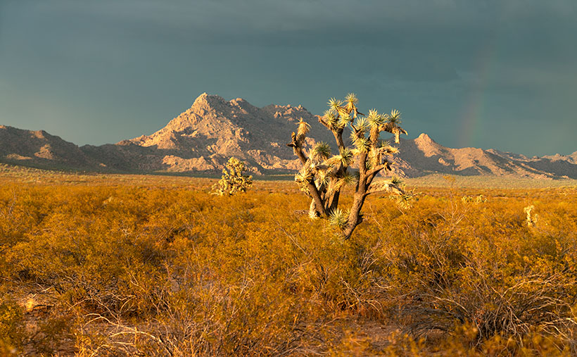
Golden-light silhouette of Joshua Trees with a dark, stormy sky over Date Creek Range in Arizona.
Storm-Lit Skies Over Date Creek Range – Caught in the golden embrace of the setting sun, the Date Creek Range and its Joshua Tree sentinel defy an impending storm. Can you spot the elusive rainbow?

In last week’s US 93 escapade, I put the pedal to the metal, racing the encroaching dark clouds to bask in the vanishing golden hour. I even detoured to Burro Creek campgrounds, where the only thing I found was…more clouds. Alas, as soon as I wrapped up my Burro Creek pit stop, those looming clouds won the race, swallowing the sun whole.

Disappointed, I set aside my camera’s relentless search for that perfect shot and started a leisurely drive home. No rush, right? Queen Anne was busy wallowing in precious metals at the jewelry store with her gal-pals, and I had miles of asphalt ahead of me. Soon enough, the highway carried me through the Joshua Tree Parkway, and then it began—Arizona’s version of ‘will it or won’t it’—raining from the sky.

Yes, this arid state has two kinds of summer rain. First, there’s the gully washer, the frog strangler, the cob-floater, a torrential rain that I can’t even see the house across the street. This type of downpour is the VIP guest that shows up uninvited, fills up the washes, and turns rattlesnakes into accidental Olympians. You should see them. Snorkels on their snouts, doing the backstroke like they’re auditioning for ‘Snakes on a Swim Team.’

Then there’s the other kind, today’s specialty: a rain so indecisive it could give Hamlet a run for his money. It’s like the weather gods couldn’t agree, and we get this annoying drizzle that teeters on the edge of being useful. You find yourself in this wiper-limbo, perpetually toggling between ‘kinda need it’ and ‘oh, the horror of that screeching noise.’ The local washes don’t even bother to fill up; rattlesnakes smirk and break out their snorkels for practice laps, just waiting for the next aquatic extravaganza.

Just when I was about to award myself the title of ‘Arizona’s Rain Philosopher,’ the universe decided to show off. The sun, ever the dramatic artist, slipped beneath the heavy cloak of the western clouds, making a brief but stunning encore. It was as if it said, ‘You thought I was done for the day? Hold my solar flare.’ And just like that, the golden hour was back on stage for its final act.

Dodging highway traffic and raindrops, I perched myself by a barbed-wire fence to capture what I’ve aptly named Storm-Lit Skies Over Date Creek Range. The Joshua Trees pop like jack-in-the-boxes from a golden sea of creosote, crowned by the glowing Castle Rock. For the eagle-eyed among you, squint a little harder. A subtle rainbow makes a cameo on the right of the taller Joshua Tree.

If you’re squinting at this on your smartphone, do yourself a favor—upgrade to a bigger screen. Trust me, this photo deserves it. You can see the bigger versions by browsing my website [Jim’s Page] or checking out my Fine Art America gallery [FAA Page]. Do make sure to swing by next week. The best is yet to come.

Till next time
jw

Techniques: Capturing Storms: The Drama Before, During, and After

Grab your umbrellas and wellies because today, we’re talking storms. And I don’t mean the kind you have with your spouse over who left the toilet seat up. We’re diving into the cinematic, the dramatic, the eye-candy kind of storms that would have made even Ansel Adams pause and say, “Well, would you look at that!”

Ah, the golden hour. That ethereal moment before the sky erupts into a Van Gogh painting or descends into gloom. But have you ever tried capturing a storm during this time? The universe throws you a curveball, saying, “Hey, here’s beauty and chaos, all wrapped in a corn tortilla of opportunity.” Remember Ansel Adams’ Clearing Winter Storm? The dude knew when to click that shutter.

You might think, “Jim, storms are just wet messes! How am I supposed to capture that?” Ah, my dry-weather fans, this is where things get electrifying. Capturing lightning requires some specialized equipment or mad reflexes. But the results? They’re shockingly good.

The storm has passed, but don’t pack up that camera yet. The sky now looks like hungover clouds meandering aimlessly, bumping into mountains, and trying to remember where they parked their cumulus cars. The aftermath can offer as many Kodak moments as the storm itself.

So, the next time you see those dark clouds looming, don’t just think about whether you’ve left the laundry out. Think about the once-in-a-lifetime shots that could be waiting for you. Embrace the wild mood swings of Mother Nature. After all, when the weather can’t decide, it might just be helping you make up yours about that next epic shot.

Do you have any of your own storm-chasing or weather-defying photography tales? We’d love to hear them! Please share your stories in the comments below, and let’s swap some epic weather adventures.

Saddle Mountain Silhouette: The View from Rincon Pass Picture of the Week - Sunflower Arizona

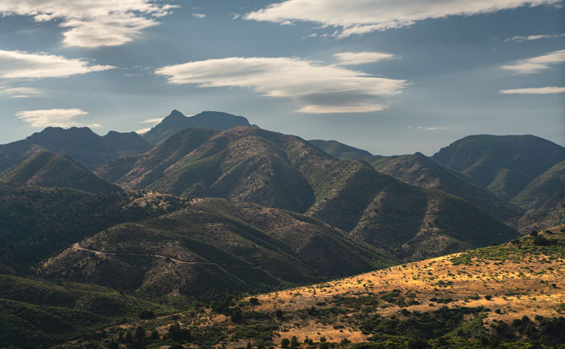
Majestic view of Mazatzal Range with Saddle Mountain silhouette at Rincon Pass.
Saddle Mountain Silhouette: A View from Rincon Pass – A picturesque landscape of the Mazatzal Range unfolds, revealing a symphony of layers and the iconic silhouette of Saddle Mountain at Rincon Pass.

Welcome back to the fourth installment of our Mazatzal Mountain tour via the Beeline Highway. With the current heat wave, our bus feels more like a scene from Romancing the Stone, filled with hot and sweaty people trying to stay cool with all the windows down. It’s so scorching outside that even chickens tied to the grill seek shade.

Of course, leave it to Queen Anne to pick the hottest week for our trip to the dentist in Algodones, Mexico. We left our comfortable haven in the Weaver Mountain foothills, where the air conditioner doesn’t run all night, only to be greeted by 115°F heat in Yuma, the lowest point in Arizona. Queen Anne’s flip-flops even melted away, forcing us to make an emergency shoe stop at a Zapata store. The trip’s highlight was the customs house with no waiting lines—small blessings in the sweltering inferno.

But enough of the heat woes; let’s escape to cooler grounds. This week’s destination is just a few miles north of our last stop, but we’ve left the Sonoran Desert behind. The newer section of the highway bypasses the shady beauty of Sycamore Creek, where there was always a respite from the sun. The creek lies on private property, and I imagine the owners are delighted to be rid of the traffic.

I pulled over near Iron Dike, a black rock mound, to capture this week’s featured image, Saddle Mountain Silhouette. In this shot, we gaze beyond the hilltop and the intricate jumble of mountains and canyons to Saddle Mountain—a fitting name for its distinct profile. Standing at 6529′, it doesn’t make the top ten of the Mazatzal’s tallest peaks, but its imposing presence seems to watch over the surrounding lesser hills.

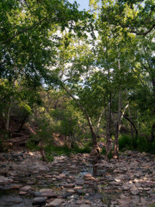
Sycamore Creek flowing amidst lush greenery and tranquil waters.
Tranquil Waters: Sycamore Creek’s Verdant Beauty – Embrace the serenity of Sycamore Creek, where the gentle flow of water and vibrant greenery create a symphony of tranquility.

After capturing this shot, we took a refreshing detour down the old road, seeking relief from the heat under the cool canopy of sycamore leaves. Though the creek’s flow was modest, it still managed to cool the air, acting like nature’s swamp cooler.

We’re thrilled you’re along for the ride this week, and we hope to have you back next Sunday for the conclusion of our Mazatzals photo tour. Before we part ways, we invite you to visit my website and view the larger version of Saddle Mountain Silhouette by clicking this link (Jim’s Web Page) and exploring the second version on my Fine Art America site (FAA link). In the comments section below, we would love to hear how you’re coping with the heat.

Until next time,
jw

Techniques: The Advantages of Shooting in RAW

In the early days of digital photography, cameras were limited to saving images in JPEG format. However, modern digital cameras now offer the option to shoot in RAW format and JPEG, providing photographers with greater creative possibilities.

RAW files contain unprocessed and uncompressed data straight from the camera’s sensor. Unlike JPEG, which applies compression and processing, RAW files retain the original data, allowing for more flexibility during post-processing.

One of the significant advantages of shooting in RAW is its ability to provide a color depth of up to 16 bits per channel. The extra bits mean smoother gradations and a more accurate representation of colors in the final image. In contrast, JPEG images are limited to 8 bits per channel, which can lead to a loss of color information and visible banding in gradients.

RAW files are stored in an uncompressed format, ensuring that all the fine details and information captured by the camera sensor are preserved. In contrast, JPEG files are compressed, which can result in a loss of image quality and visible artifacts, especially in areas with high contrast or fine details.

RAW images can capture a more expansive color space, allowing for more vibrant and accurate colors in the final output. On the other hand, JPEG files, due to their compression and limited color depth, may exhibit color shifts and loss of detail, particularly in highly saturated or subtle color areas.

Shooting in RAW gives photographers more creative control over their images. It enables them to adjust to exposure, white balance, contrast, and other settings after you’ve taken the shot. This flexibility allows photographers to fine-tune their images to match their artistic vision and achieve the desired look.

When editing RAW images, the adjustments are non-destructive, meaning the original data remains intact. This safeguard ensures photographers can revisit their edits and make changes without compromising image quality. In contrast, directly editing a JPEG file can result in losing quality with each revision.

One of the significant benefits of shooting in RAW is the ability to convert and save images as PSD (PhotoShop) or TIFF (the Competition) files while retaining all the layers and adjustments made during editing. This feature allows photographers to maintain a master copy of their edited images, enabling future adjustments and re-editing without losing image quality.

While shooting in RAW is essential for maximum creative control and image quality, there are instances where photographers may need to save images as JPEGs. Converting the final edited image to JPEG format reduces file size and ensures compatibility for web uploads, social media sharing, or submission to specific platforms.

By shooting in RAW format, photographers have the flexibility to fully explore their creative vision and create stunning images that retain the true essence of the scene.

White Pickets and Red Bricks The Town Too Tough to Die

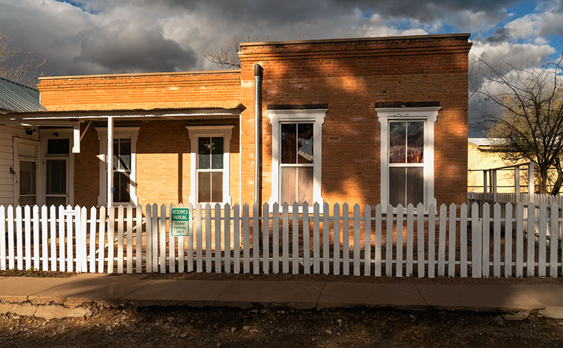
White Pickets and Red Bricks - A break in the cloudy sky let sun light the face of a Tombstone Apartment.
White Pickets and Red Bricks – A break in the cloudy sky let the sun light up the face of a Tombstone Apartment.

You may have noticed that history is one of my frequent photo themes, whether it’s human history, historical buildings, or the geologic origins of a mountain. I don’t know where this passion came from because I was a terrible history student in school—I could never keep my dates straight. Maybe it’s an old-person thing. Ironically, we geezers try to cram useless facts into every unused nook and cranny in our brains, only to drop dead before using any of it.

Whenever Queen Anne and I visit a place like Tombstone, we like to see all the hot spots that every tourist goes to. The gunfighters, the courthouse, the palatial bars, and we even rummage through the gift shops (ya gotta have new T-shirts). When I get home and write about my photos, digging up the background on the above subjects is relatively easy. But, as is the case with the building featured in this week’s picture, not every historical building has a bronze plaque.

When I shot the Tombstone County Courthouse featured a couple of weeks ago, I started across the street and circled the building. I snapped images as I went, but I was looking for something different—an angle no one had seen. The shot I presented was taken from the alley out back, and the wall, tower, and clouds gave me what I wanted.

When I finished my loop, I was back at the starting point—in front of a red-brick home across the street from the courthouse. This century-old home doesn’t have a written story—well, not online, it doesn’t—but I want to know more. Who was it built for? Why was it converted into apartments? Where did they get all of those bricks?

I’m a sucker for picket fences. I would never own one because they’re a pain in the ass to maintain, but I can’t pass one without getting out my camera. I took two versions of this photo; the first was when I started my courthouse walk. In that one, the sky was overcast, and the building was entirely in its shadow. When I finished my lap, the clouds had partially opened, allowing the sun to shine light onto the apartments. This pattern of light and shadow is my favorite light. Here’s why: if you combine the way the building is lit and the broken clouds in the sky, this scene will never happen exactly again. That means I captured a specific moment that can never be reproduced. If you think about it, it’s a moment of history.

I called this shot White Pickets and Red Bricks because those are the essential elements that make up this image. You can see its larger version on its Webpage by clicking here. I hope you’ll join us next week when we come back with our final Tombstone image.

Till next time
jw

BTW:

I want to note this week’s passing of David Crosby, a founding member of two bands that were part of my formative years; the Byrds and Crosby, Stills, and Nash (and subsequent derivatives). They pioneered the transformation of folk music to folk rock. Several of David’s albums in my collection get regular rotation in my listening room. Peace-out David.

KofA Thunderhead Picture of the Week

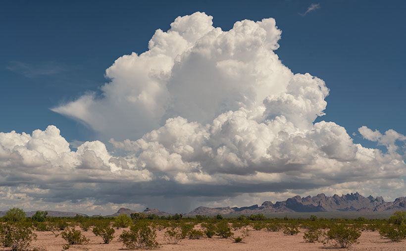
KofA Thunderhead - An autumn thunderhead builds over the KofA Mountains in western Arizona.
KofA Thunderhead – An autumn thunderhead builds over the KofA Mountains in western Arizona.

Each time Queen Anne and I jump into the car; I pack a camera in the back seat. I don’t mean on local errands like a trip to the grocery store but on drives longer than an hour. Rarely do I stop to take a picture, but should one of those once-in-a-lifetime moments happens, I’m ready.

If I capture some unique photographs, they don’t fit our usual workflow. We usually pick a location as a month-long project and photograph enough shots for a month of articles (or even a book). My one-of-shots along the highway traditionally become forgotten orphans. No one gets to see them—until now.

For December, I decided to make this month’s project out of the non-project shots I collected this year. With these four pictures, a special moment made me pull over and stop the car. That’s pretty hard to do because once I have a destination set in my mind, I only stop for gas, a candy bar, and bladder relief.

Anne and I run to Mexico about four times a year. We go to Algodones to see our dentist and buy 90 days worth of prescriptions. We’re on Medicare, and we have a gap plan that pays for most of the pills we take, but some of the select drugs (hint: you see them advertised on TV) are so much cheaper in Mexico that it pays for the drive. If we don’t have to wait on the dentist, we can make a drug run in a day. We leave here at 8:00 am, walk two blocks across the border, stop at Mickey D’s for lunch, and get home by 5:00 pm.

That was our itinerary on September 22—the first fall day. As we drove home on Highway US 93, I watched a single thunderhead building thirty miles north over the KofA Mountains. I thought it unusual to have monsoon activity in autumn and a single storm cell develop so far west in Arizona. I spent the next half hour arguing with myself.

“That will be a great shot if the clouds hold together until we get there.”

“If we stop, we’ll get home after dark.”

“It’s an isolated cell, and it’s posing like a runway model.”

“It’s the wrong time of day, and the light is wrong.”

Just after passing the Border Patrol station that marks halfway between Yuma and Quartzsite, I noticed that the cloud was beginning to tear apart (the wispy part on the tower’s left side). It was time to stop the car. I reached back for my camera and hiked a few steps off the highway. I set the zoom-lens as wide as possible before framing and then snapping a couple of shots. I call this week’s featured image KofA Thunderhead.

The spot where I stopped was several miles away, and for perspective, the jagged KofA peaks rise a couple of thousand feet above the 500-foot high basin. That makes the billowing cumulus top nearly 40,000 feet in the air. Unfortunately, I didn’t capture any lightning strikes beneath the storm.

We returned to the road and continued the drive, watching the storm evolve. The upper winds blew the clouds apart by the time we were due east of it. That’s when we saw a funnel cloud drop below the ceiling. The tornado briefly touched the ground near Crystal Hill Road before it disappeared.

We weren’t done with it yet. After stopping for gas in Quartzsite, the storm ambushed us on the pass at Guadalupe Mountain. As it moved north over Interstate 10, it dumped rain so hard that the wipers couldn’t keep up, and traffic slowed to a crawl. We hoped we wouldn’t be surprised by a second tornado, but after a mile or so, we broke into the clear, and the deluge was only an image in the mirror.

You can see a larger version of KofA Thunderhead on its Webpage by clicking here. Next week, I’ll drag out another orphan photo for show and tell. We’ll see you then.

Till next time
jw

BTW:

Anne and I are negotiating next year’s schedule, so there will be a lot of yelling and screaming around here during the holidays. Pay no attention to the man behind the curtains.

Lomaki Picuter of the Week

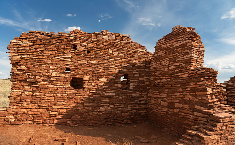
Lomaki - The crooked walls look as if the fierce Northern Arizona winds will blow them over.
Lomaki – The crooked walls look like the fierce Northern Arizona winds will blow them over.

In the half-century that I’ve called Arizona home, I can’t count the times that I’ve traveled thru Flagstaff and then north on Highway U.S. 89. I travel that route to get to the Grand Canyon, Lee’s Ferry, Lake Powell, Monument Valley, Utah, or Colorado. My best guess would be once a year on average. Sometimes I even stop to take pictures along the way.

With that many trips, you’d think I’d pay no mind to the scenery, but that’s not true. There’s always something new. There’s one location that makes my jaw drop, no matter how many times I see it. I’m talking about the view at Sunset Crater Pass I wrote about last month. It’s an in-your-face example of something I learned in a college geography course: mountains affect climate.

The climate on the south side of the San Francisco Peaks is the polar opposite of that on the north. As you travel to Flagstaff from Phoenix, you climb into the pines, and the temperature can drop as much as 30° along the way. As fronts move north from the Gulf in the summer or west from the coast in winter, the mountains wring moisture from the air as it climbs the slopes. After passing over the mountains, the air is dry and picks up pressure on the way down. Dry air heats faster than humid air. The phenomenon creates a rain shadow on the mountain’s leeward side. The next time you travel north of Flagstaff, stop your car at the pass and take a look back—trees. Then turn to the north again—trees kept away.

Now that you know how mountains work, it’s easy to understand why the early Pueblo Tribes living at Wupatki lived in rock dwellings instead of log cabins. Amazingly, the Indians still used timbers to span the walls and hold up a roof. That means they had to drag lumber off the mountains by hand. They built their structures before the Spanish arrived, so they didn’t have horses.

This week we’re looking at one of the bigger pueblos in the National Monument—Lomaki. That’s a Hopi word that translates into English as “Beautiful House.” Anthropologists have partially restored its two-story walls. As you walk through the ruins, you begin to appreciate the ancient people’s masonry skills and tenacity. They must have had to rent scaffolding for walls that size at A-Z Rentals in town. It was either that or standing on one another’s shoulders. You’d do the same thing.

In this week’s picture, titled Lomaki, you get a good idea of the wall height. The windows are at eye level. A peculiar thing you notice in this shot is the walls are leaning. I’m not sure if the scientist put that feature in on purpose or if they weren’t as skilled as the original Pueblo builders. As a photographer, I have a thing about lines that aren’t level or square. Oceans don’t run downhill, so I wince whenever I see a seascape with a crooked horizon. On my first visit to Lomaki decades ago, its tilted walls jumped out at me. They look like a good wind will blow them over—and this area of Arizona is exceptionally windy. However, on this year’s visit, the walls were still standing and didn’t seem any worse, so maybe they’ll remain long after I’ve gone.

You can see a larger version of Lomaki on its Webpage by clicking here. Next week, we’ll walk around Lomaki and see its details. Come back then and see what we find.

Till next time
Jw

BTW:

The calendar cut-off day is Tuesday, so if you are interested, place your order.