Making Lemonade 2018 Utah Photo Shoot

As teenagers growing up in Los Angeles, we were ambivalent about the Santa Ana Winds. They would clear the air in the LA Basin, pushing it offshore where it was somebody else’s problem, and for a week or two, you could see where you lived and enjoy the beautiful mountains surrounding us. But the winds also dried out the scrub. Dry enough, a careless motorist could fire by flipping a cigarette out the window. Fires are a way of life in Southern California. They’re annual, but you don’t get used to it.

As a kid, I saw how smoke can choke the air, but I also saw a phenomenon helpful to photographers, although that didn’t sink in until I was older. When heavy smoke fills the air, it filters the sun—like sunglasses. During sunsets, the sun is an orange globe that you can look directly at. The smoky atmosphere causes beautiful orange sunsets. I don’t know if you’d call that a benefit, but they’re unusual.

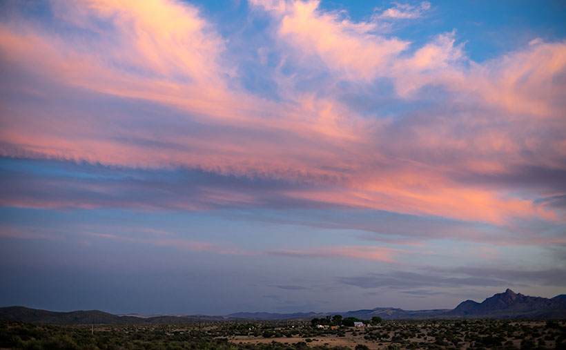
After Monday’s shooting, I was processing some photos for yesterday’s blog when I glanced at the setting sun through Ritz’s window and saw an orange sun. Yesterday, as I wrote, I thought about trying to capture a sunset from my teenage memories. I decided to give it a go, and at 7:45, I drove north on US 89, looking for a suitable foreground for my sunset experiment. I settled on a spot where the sun would go down behind a lovely mountain—Sandy Peak. As a bonus, there was a vast field sprinkler spraying streams of water that would glow with the backlighting. I exited the truck and sat by the roadside, camera in hand, and waited.

The smoke in the air must have dissipated because as the sun got lower, it didn’t get duller, although it still had a tint of orange. I knew I would need to wait for the sun to kiss the mountain for the shot to work. That meant shooting when the sun was most colored anyway. Then, at 8:00, four children burst out of the house to my left. One got on a quad and started driving around while three girls—judging from the long dresses they wore—began running toward the sprinkler. When they got there, they turned off my sprinklers. I’m talking about one of those massive machines you see in fields moving on wheels in a circle. I’d be afraid to touch it, and these children turned it off like the hose in the front yard.

I thought about leaving, but the sun was inches away by then, and the girls hung around the fixture, so I adjusted the camera to bring up the foreground and started shooting until the sun slipped halfway behind the mountain.

Sandy Mountain Sunset
Sandy Mountain Sunset- This is my failed attempt to capture an orange sunset, but the story is nice anyway.

Here is my last and best shot. The smoke wasn’t thick enough, the water wasn’t spraying, and I have live humans in my photograph, but I thought I’d share my evening with you—at no extra charge. Can you find the girls? They’re there, I can assure you. Now, I can go back to shooting inanimate objects.

Until next time — jw

Cedar Breaks National Monument Utah Photo Shoot

Cedar Breaks Amphitheater - Cedar Breaks is a five-mile amphitheater that looks like someone took an ice cream scoop to it and left behind the candy toppings. The distant peak is Brian Head at over 11,000', where the ski resort is located.
Cedar Breaks Amphitheater – Cedar Breaks is a five-mile amphitheater that looks like someone took an ice cream scoop to it and left the candy toppings. The distant peak is Brian Head at over 11,000′, where the ski resort is located.

Yesterday could have been the perfect day to visit Cedar Breaks, the mini version of Bryce Canyon high on the eastern edge of the Markagunt Plateau in southern Utah. The muggy weather that had hung around all weekend moved out and it was dry and sunny with a light breeze from the west. As we entered the park the car’s temperature indicator said it was 68° outside. Conditions couldn’t have been better for an afternoon of hiking and picture-taking.

It wasn’t this nice the first time we visited Cedar Breaks. That was Memorial Day weekend in 2004. The Queen and I decided to get out-of-town to escape the 115° weekend. We had tossed the camping gear into the truck and left before dawn dressed in shorts and tee shirts. We drove straight through only stopping at the Flagstaff Mickey D’s for an egg-a-muffin. That truck didn’t have an outside temperature gauge and it barely made it up the 12% grade. We still had the air-conditioning on when we stopped in the parking lot. It was a sunny afternoon, but when we opened the doors, a blast of Arctic air greeted us and chilled us to our bones. We scrambled to find our jackets. At 10,300 feet, Cedar Breaks can be hostile.

Tee shirts and shorts were the perfect uniforms yesterday. That wasn’t a problem. The issue that I had was in the air. Up here, it’s normally clear and pristine, protected by its remoteness, but because somebody’s trying to burn down California, the air was filled with smoke that traveled across Nevada. That smoke-filled air is not conducive for taking detailed landscape panoramas. I had to change my mindset and look for more intimate images.

Bristlecone Pine
Bristlecone Pine – Probably over two thousand years old, bristlecones survive by shutting down damaged parts and only supplying new growth with nutrients.

From the visitor’s center, there’s a short one-mile hike to Spectra Point—an overlook that has a grove of large Bristlecone Pine trees. I’ve always admired these Methuselah trees for how they live for thousands of years in places where nothing else will grow. I had heard about them on my last trip, but it was spring thaw with snow covering parts of the trail and the rest being a muddy bog. That wasn’t an excuse today, so I put on my new camera backpack and balanced the tripod on my shoulder and set off to conquer nature.

Fins, hoodoos, and arches.
Fins, hoodoos, and arches – As the soft sandstone erodes it breaks down into long structures called fins. As the fins erode they leave individual spires called hoodoos. During that process, the bottom of the fin may fail and collapse leaving a window or arch. There are examples of all three in this photo. Can you spot the arch?

The trail actually leads to two overlooks, the second one being Ramparts. As I started skipping along I considered going the extra mile—as they say. It looked doable on the map because the parking lot is 10,300′ and Spectra point is 10,285′. A mere 15-foot drop—posh, child’s work. Ramparts, however, is 9,985′. I decided to see how I felt when I reached Spectra Point—after all, I have ridden a bike five miles every morning, so I’m buff … Right?

My skipping immediately ceased when I turned a corner and reached the base of a 300′ hill that’s not on the map. You can guess what my decision was already. I can walk three miles in an hour at home, but in the thin air, my trip took 45 minutes. I spent an hour shooting trees and views along the rim before heading back to Archie—our truck, where Anne was reading a book. You’d think she’d have carried the camera bag or a picnic basket or something. When I opened the back door in my sweat-soaked shirt and loaded the equipment while panting, all I got was, “How was your little hike dear?”

We spent today recuperating—she broke a nail—and I processed a couple of photos to show you. At dinner, we’ll decide where next to explore. We’ve concluded that the smoke has permeated Utah and we’ll just have to work around it, but we’re going to have fun even if it kills us.

Until next time — jw

Kanab Overnight 2018 Utah Photo Shoot

We stopped short of our target destination—Panguitch—by a hundred miles because I wanted to shoot along the lower Paria River. I was hoping to shoot a couple of areas that I previously visited bathed in a late afternoon sun. Instead, it rained. I captured some nice images anyway and Queen Anne followed me most of the way up the trail—including a bit of the climb. That was a miracle unto itself.

Dune at the Toadstools
Dune at the Toadstools – This is one of the images taken at the Toadstool stop along US 89. It was the first time I hiked up to them. To her credit, Anne followed me most of the way.

Our temporary site is in Kanab and the RV Park we originally stayed in during our Alaska adventure. New owners bought the place a couple of years ago and have made improvements. I’d have to rate it as one of my favorites—although truck traffic still starts early. Last night we enjoyed a fine meal at the Rocking V Cafe. It’s the fourth time we’ve stopped there without disappointment. Anne was perturbed that they didn’t serve their macaroni and cheese for dinner. She had been going on about it all day and nearly beat up the poor waitress when they wouldn’t make some especially for her. Instead, Anne wound up enjoying the curry dish that she ordered.

We’re packing up this morning and making the pull up to Panguitch. It’s another thousand feet higher and ten degrees cooler so that suits Anne’s prerequisite. It’s also centrally located to the areas that I want to shoot. We will be pulling The Ritz for a couple of hours so we’re not in a rush this morning. As a matter of fact, it just turned 8 am and I rousted her highness from the sack. If she stays in character, she’ll dawdle all morning so that we’ll have to stop at the Rocking V for a lunch of Mac ‘n cheese.

Until next time — jw

Timberline Picture of the Week

Timberline
Timberline – The subjects of this image suggest that it is on a scale larger than it really is.

The wind was warmer than I expected at this altitude. Blowing on my back, it seemed to help push me along the John Muir Trail in California’s High Sierra’s. The Mt. Whitney Trail was only a half mile further when I stopped to snap this photo of massive granite formations along the tree line.

I just made all of that up. My chances of hiking those famous trails have long vanished, but this week’s photo has a sense of scale that could work with a fictitious story like that. I took this photo I call Timberline at the Granite Dells along with the others featured this month. It’s the angle that fools the eye so that you think you’re looking at a craggy mountaintop. The trees also play tricks with your sense of scale. They’re actually shrub-size like they were scale models of ones that are much taller—bonsai versions if you will, and the sheer drop in the lower left isn’t the hundreds of feet that it seems. It’s only a dozen feet over your head as you hike the Flume Trail to the park’s northern boundary.

The reason I included Timberline in this month’s set is that it distills the Granite Dells into three simple elements; massive rocks, trees eking a living in hostile conditions, and the changing sky over them. The photo speaks of weight—or mass—and it shows a time contrast of a changing sky and momentary life against the permanence of the weathered granite. The sky changes hourly while the trees will be different in a century, but the granite will survive the next millennia unaltered.

You can see a larger version of Timberline on its Web Page by clicking here. I hope you enjoy viewing this week’s post and come back next week when we start a new set of images from a new location.

Until next time — jw

Art and Flowers Picture of the Week

Jerome Iris
Jerome Iris – One of my better selling images. It was taken in 2004 on a Jerome trip I made with my friend, Russ Good.

I took this photo of iris in front of a cracked foundation wall in 2004 when my friend, Russ Good and I went to Jerome on a photo-shoot. It’s a popular image and has sold well. The photo’s story is the contrast—the softness of iris petals against the hardness of the concrete foundation and the vibrant purple flowers in front of dull concrete. It also speaks about longevity. The family that planted the flowers and the house they decorated are gone but the bulbs put out new flowers each spring without a caretaker. Getting this shot was difficult. I remember lying on my stomach in the street to focus the image on my 4×5’s ground glass while Russ stood guard over me. Each time I visit Jerome, I look for similar setups and I found another one that is this week’s image.

Art and Flowers
Art and Flowers – Not just a pretty flower picture. Someone watches that you don’t pick them.

I titled it Art and Flowers and I shot it from the sidewalk in front of the Hilltop Deli building on SR-89. Because my newer camera has a folding view-screen, I didn’t have to get down on the ground this time. Getting down is one thing but—at my age—getting up is another set of variables entirely. The hollyhocks seem to be popular in Jerome this year, they were in gardens everywhere. I selected this specimen because of the jagged wall behind it and the dark crawl space it frames. As you study the image, does it seem like someone is watching you? Well … you’re right. As I was shooting this, I tried different angles and in the middle of shifting positions, I noticed a painting on the wall inside the crawl space. It’s a portrait of a young lady—her chin resting in her hands—painted inside the opening in such a way that you don’t see it as you walk along the sidewalk. I don’t know who the artist was or how long it’s been there, but it’s not just graffiti. After I saw it, I knew I had to frame my last shot so that the hollyhock was in front—but not obscuring the painting—and I set my exposure to make the eyes barely visible in the background. It’s like one of the apparitions that Jerome is famous for. If you visit the version on my home-page—while this image is on display there this month—more of her shape revels as the image lightens.

You can see a larger version of Art and Flowers on its Web Page by clicking here. I hope you enjoy viewing my newest entry and come back next week when I post another Jerome photograph.

Until next time — jw

Ps: Thanks to Glenda Meyers and Sharon Roberts for flower identification.

Jerome, Arizona In Yavapai County

When I first moved to Arizona in 1972, I hung out at a certain Scottsdale Restaurant. It was a trendy steakhouse that had a minimalist décor of white walls with dark wood trim and original oil paintings—on loan from a gallery—decorated the walls. One painting in particular that impressed me was of an eagle emblem with a broken wing positioned over the word Liberty. The design was simple enough to be a graphic poster, but the style was photorealistic and it looked as though it could be a building sign. This was back when we all had long hair and wore bellbottom pants, so I thought it was a political statement when I first saw it.

“Oh no, that’s the Liberty Theater in Jerome,” my waitress corrected.

“Jerome, what’s that?” I asked.

“It’s the ghost town near Sedona. You’ll have to go there sometime.”

Jerome's Liberty Theater
Jerome’s Liberty Theater-My introduction to Jerome came about from a painting of this façade. Back then, part of the eagle and lettering hadn’t fallen off.

So I did, and as I wandered the streets of the old copper mine town, I felt strangely comfortable—like I had always known this place. There was something familiar about its terraced streets lined with white clapboard row-houses. Jerome reminded me of the Pittsburgh neighborhood where my great-grandmother’s—Busha—apartment house was, and where my family lived until I was in the first grade. I remember it was on Bigelow Boulevard—a wide thoroughfare that ran east from downtown up a long grade onto Pollock-Hill—the local slur for the neighborhood. Just like Jerome, laborers built our community on a mountainside on unsuitable plots and walked to work up and down endless staircases. Our apartment at Busha’s was on the second floor if you came through the front entry, but from the backyard, we were on the fourth floor of a five-story building.

Growing up in neighborhoods like these isn’t for the feeble. My preschool playmates and I would test our balance by walking along the top of the retaining wall supporting the boulevard. It was a couple of feet wide, but the sheer drops would have killed us had we fallen. Another example of peril was in our apartment’s backyard. It was paved with bricks and the neighbor’s yard was low enough that we could jump from our fence rail, over a three-foot gap, and onto the neighbor’s wood-shed roof, which—as kids always do—we double-dog dared each other to do. The jump to the roof was easy. Just climb to the top of the railing and leap onto the roof. However, the return flight required clearing the four-foot rail. I mastered the jump several times before I missed and crashed head-on into the guardrail. As gravity drug me down, I saved myself by grabbing and holding onto the railing’s bottom pipe. I hung on for dear life above the abyss and started screaming so loud that my mother could hear me four flights away. I almost lost my grip when she finally came to my rescue and as she started to pull me up, she couldn’t hold on and I became a human pachinko ball as I ricocheted between the concrete retaining wall and the shed siding. I survived the fall but not without a slight scar under my right eye that is only noticeable as a bag under my eye when I’m tired. Then, my eye has a noticeable bag under it. I don’t know what hurt worse, the bloody cut or the beating I got when my dad got home.

Flatiron Building
Flatiron Building – The Flatiron is located below downtown and it is where AZ-89 divides into two one-way streets. In the background is the House of Joy Brothel that was one of Arizona’s best places for dinner.

It’s been more than ten years since we’ve been to Jerome, and a couple of things struck me when Queen Anne and I visited last week. I didn’t understand at first, but there is a sense of openness now. Most of the abandoned homes have been torn down. Jerome was full of decaying houses that had crumbling foundations, sagging roofs, and signs on them that said, “Condemned – Danger – Keep Out.”  Those are gone now. The buildings that remain have been extensively restored and reinforced. There are a few new homes built on the vacant lots, and that’s good to see.

The other big change is disappointing to me. It’s the closing of the House of Joy. The historic brothel was once one of Arizona’s première restaurants but it’s closed now and the building is for sale. Eating at the House of Joy was a big occasion and a good reason for spending a night in Jerome. I’m sad that I missed the chance to dine there. Most of the current eateries are open only for breakfast and lunch, so except for the geezer cover-bands playing at the Spirit Room, evenings in town must be quiet.

Spirit Room
Spirit Room – The bar is in the Connor Hotel building. On weekends, dozens of motorcycles fill the parking spaces while middle-aged professionals are inside having a beer while listening to a geezer cover-band playing classic rock songs.

Jerome is still a great place to spend a day out of the valley. There are plenty of stores on Main Street to buy a tee-shirt, try on jewelry, admire local art, enjoy an ice cream cone, or relax with a cold beer. There are more haunted buildings than ever, and the museums and mine are worth visiting. Jerome, as always, is one of the spots that you take your eastern relatives so they’ll get an idea of Arizona’s history and geographical diversity. It’s just … the old ghost town is more refined now and not the rough and tumble kind of place I first knew.

Until next time – jw

House with a View Picture of the Week

It’s June already and our wall thermometer is reading over 100º so it’s time to shoot somewhere a little cooler. Queen Anne and I racked our brains to come up with a scene close enough for day trips, and we decided to focus on Jerome this month. It’s a ghost town close by, it is a mile high clinging to the side of Mingus Mountain, and it is cooler than here. I have personal recollections about Jerome that I plan on sharing later this week, but Sunday’s are reserved for new picture announcements, so let’s get on with it.

I’ve photographed Jerome several times over previous decades and I already have a library of the town’s familiar buildings, so on this trip, I wanted to look for details that give Jerome character—you know—the artsy pictures. I got some shots that fit that bill, but to set the stage for Jerome Month, I wanted to start with an image that would give people who have never visited the town an idea of its geographical placement, and I think this week’s featured image does that.

House with a Veiw
House with a View – Building and maintaining a home on a mountainside is a daunting task. But like this house in Jerome, the views are priceless.

I call this image House with a View and it is one of the few private residences that has survived intact. It’s a modest home that is one story on the street but has three levels at the back. It’s a brick building indicating that it was home to a family of means—like a mine manager. To me, it shows how steep the slope of the lot it’s on and how much engineering it took to keep the house from sliding into Clarkdale below. Conversely, the upside of being tethered to a mountainside is the million dollar view of the Verde Valley two-thousand feet below—and to the north, the red rocks of Sedona. Can you imagine having cocktails on that veranda while watching the sunset on the southern edge of the Colorado Plateau?

You can see a larger version of House with a View on its Web Page by clicking here. I hope you enjoy viewing my newest entry and join Queen Anne and I as we show off Jerome this month.

Until next time — jw