Richardson House Picture of the Week

Richardson House - The remains of the home that John Richardson built on their Union Pass homestead.
Richardson House – The remains of the home that John Richardson built on their Union Pass homestead.

At the beginning of May, I had to make another Algodones run. I broke another tooth and needed our dentist to look at it. Since Queen Anne had company, I traveled alone. These frequent dental visits have gotten old. When we travel to Mexico, it’s not for fun. Being an old codger, I’ve been wondering what advice I have for the following generations, and one thing that comes to mind is this: “Kids if you’re hoping to live past 35, take better care of your teeth.” I could have bought a boat with all my money wasted in my mouth.

My stay in the chair wasn’t extended. The doctor looked in my mouth, chattered in Spanish, ground down the pointy parts, handed me a jar of antibiotics, and said, “Come back in two weeks. We need to dig the old tooth out.” They set me free, and it wasn’t even noon.

I could have driven home, but the house was full of visiting women, and I’d be like a third thumb. Since I wasn’t expected home for another day, I drove north, following the Colorado River to Laughlin, where I could enjoy another boy’s night out. I had my camera to tend to some unfinished business.

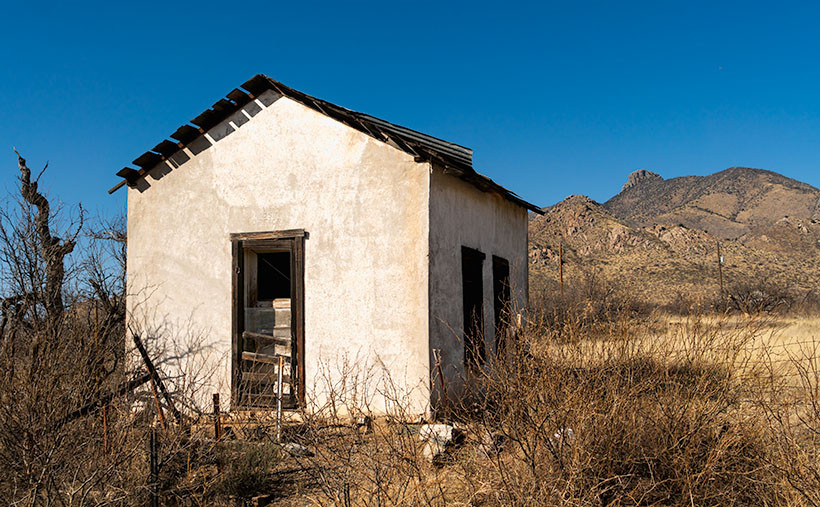
My featured project after my last Nevada visit in September was the marvelous rock formations near Union Pass. That’s where Mohave County Route 68 crosses through the Black Mountains and begins its descent to the Colorado River. While researching my articles, I learned about the Richardson family and their Union Pass homestead. I told their story in my pBroken Crown post, so I won’t burden you here by repeating it. At that post’s end, I said I wanted to go back and spend some time shooting the homestead’s ruins, and that’s why I spent the night in Laughlin.

Unfortunately, a law of entropy states that things on their own will decay—they fall apart. There’s a set of humans who enjoy helping the process. That’s why I wanted to return to Union Pass soon, and I’m glad I did. Pictures showed the gas pump island cracked but intact. On my visit, someone utterly destroyed it. However, there were enough ruins left that I spent most of the morning wandering and shooting.

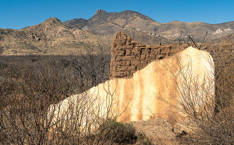
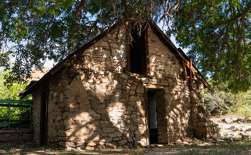
The first picture for this month’s Richardson Homestead project is the two-story house hand-built by John using local stone. It is nestled in the shade of an Arizona Ash. The tree covers the two-story structure with the dappled light that I love. Compared with earlier pictures, someone has torn down the large cross on its right side, and graffiti now decorates the front retaining wall (off-camera and purposefully not included). The house is the most intact building on the homestead. With over forty years of neglect, it hasn’t fallen.

I’m sad that Mohave County or the BLM hasn’t set this property aside as a park or a protected historical site. Without that protection, I expect this place to be gone before future generations learn about the Richardsons and their homestead. Although a complete restoration would be ideal, simply keeping it in a state of arrested decay would be the first step. For example, at the Gillespie Dam and Bridge, Maricopa County’s interpretive center was built to explain its historical significance. Something like that would hopefully deter vandals from running amuck. Hand me a petition; I’ll sign it.

You can see a larger version of Richardson House on its Web Page by clicking here. Next week, we’ll pick through the Richardson ruins to find other artistic shots to show you. Be sure to come back and see them.

Till Next Time
jw

White House Picture of the Week

White House - An abandoned dwelling of some sort in the ghost town of Dos Cabezas.
White House – An abandoned dwelling of some sort in the ghost town of Dos Cabezas.

Ghost towns are a big business in Arizona. That’s good because we have our fair share, and a few of them attract many tourists. They’re our Disneyland. As soon as your relatives hit the tarmac and demand to see the state, the first suggestion out of your mouth is, “Let’s go to Jerome (Bisbee-Oatman-Tombstone-etc.).” You’d think that, by definition, ghost towns are abandoned places—they had their heyday long ago, but the residents left when things went south. But, that’s not necessarily true. The population count in some of our mining towns rivals the numbers they had in their prime. Our hometown of Congress is an example. People move here to get away from Phoenix’s smog and traffic—or the Minnesota snow—and they’re all on the road and in my way.

I’ve concluded that somebody loves it and wants to live there no matter how remote one of these places is. Take the town I introduced last week—Dos Cabezas. Among the derelict buildings, there are two surviving businesses. One is an art studio/gallery (Dos Cabezas Art Gallery), and the other is a bed and breakfast (Dos Cabezas Retreat Bed and Breakfast). At least those are the two places that advertise their presence. There are several cattle ranches in the area, and there is an emerging wine presence, but not within the town limits.

I don’t know anything about the gallery, but enjoying a glass of local wine while staring at the stars on the B&B patio would be a treat. Since it’s closer to the Chiricahua National Monument, it’s an alternative to the chain hotels or downtown dives in Willcox. The two guest rooms are in an adobe walled casita, and as the name implies, the hosts include breakfast. A drawback for Queen Anne and I would be dinners. The nearest restaurants are 15 miles away in Willcox or Douglas, over an hour’s drive south. If you’re a person that needs bright lights and noise to sleep, the retreat wouldn’t be your cup of tea—the nights in the middle of Sulphur Springs Valley are exceptionally dark and silent.

As you can tell from this week’s picture, the little ghost town is at the foot of the Dos Cabezas Mountains. It’s near the range’s southern reach, so you can only see the south head (Cabeza). There’s a road and trails that will get you to the top, where I imagine the view of the valley and Willcox Playa is spectacular. You need permission to cross a locked gate, and the top is steep, so why bother?

In this image that I call White House, I assume it was a dwelling. It’s a palace compared to some of the miner’s shacks I’ve seen. Unlike the other buildings in Dos Cabezas, this one is a fixer-upper. You have affordable housing with a bit of paint, a few shingles, and a yard clean-up. But there’s probably a community historical committee that needs appeasement, so you can’t paint it purple.

Unlike last week’s photo, the white stucco pops against the brown mountain and clear blue sky, and I like that. There’s plenty of side yard where I visualize Queen Anne hanging laundry on a solar drier. Then, this would be a picture that Norman Rockwell or Andrew Wyeth would envy. Where’s the Saturday Evening Post when you need them?

You can see a larger version of White House on its Web Page by clicking here. Next week, we continue down County Highway 186 in search of an image worthy of another car stop. Please join us.

Till Next Time
jw

Adobe Ruin Picture of the Week

Adobe Ruins - In the ghost town of Dos Cabezas, most of the remaining buildings are severely decayed.
Adobe Ruins – In the ghost town of Dos Cabezas, most of the remaining buildings are in a severe state of decay.

Roughly midway between Willcox and the Chiricahua National Monument, the county highway’s speed limit drops to 45 mph. At first, there’s no clue about the slowdown until a small sign announces that you’re entering the town of Dos Cabezas. Only three of its dozen or so buildings are worthy of occupancy. The rest are in various states of decay. It’s only a city block long, and you soon return to an empty country road, where you can reset the cruise control.

After driving through Dos Cabezas three times, I insisted on stopping on our fourth pass. As regular readers know, I’m a sucker for historic buildings, whether they’re restored or about to be blown down by the wind. I’m glad that I did, and this week’s featured shot is one of several that I captured during that afternoon.

As with most Arizona ghost towns, Dos Cabezas’s history is a flash of glory followed by a long decay period. The town is located at the southeastern reach of the mountain range, which shares the same name. When word came out that prospectors discovered gold and silver on the mountain, miners swooped in like hungry vultures to feed on a carcass. The Feds opened a Post Office in 1878, which served a population of 300 that eventually swelled to over 4000. They found little gold in the Elma mine, but there were some copper deposits. Investment capital dried up when investors discovered that the mine was a scam and part of stock fraud. People left to find work elsewhere. As the town dwindled, the Post Office finally closed its branch in 1960. I guess that you could count today’s Dos Cabezas citizens on one of your hands.

In this picture that I call Adobe Ruin, you see the remains of a large building constructed using adobe bricks and stucco. The town once had a hotel, and these sections may be all that’s left of it. Adobe was a common building material throughout the old southwest because it was simple to make. All you need is to combine mud and straw and let it dry in the sun. The thick bricks provide plenty of protection from the desert heat and cold winters, but they quickly erode once water enters them.

I took several variations of the building, but I favored this one because I liked the mud stains streaking down the wall, and I liked the wall’s placement before the background’s two-headed mountain. The desert willow and hackberry show how soon nature reclaims her own. Ashes to ashes, as it were.

You can see a larger version of Adobe Ruin on its Web Page by clicking here. Next week, we’ll walk down the street to look at another of the Dos Cabezas ruins. Come back then and have a look.

Till Next Time
jw

The Grotto Picture of the Week

Grotto Interior - From the outside, the Grotto looks like a secluded place to hide from the world.
Grotto Interior – The Grotto looks like a secluded place to hide.

Over the past couple of weeks, we’ve been hiking and photographing the Grotto Trail in the Chiricahua National Monument. I know that seems like a long time for a one-mile trail, but I’m old and quickly fall. As you’ve seen in previous photos, massive rock formations that sometimes resemble sculptures line the track. That’s another reason the hike takes me so long—I can’t pass up these shots.

As I walked through the towering erosion formations, I wondered how the grotto would look. By definition, they’re a ‘picturesque cave,’ so I wasn’t sure what I was looking for. I shouldn’t have worried because, as that old proverb goes, “You’ll know it when you see it.” That’s precisely what happened. When I first peeked through a side window, I shouted, “Eureka, I’ve found it.”

It’s a cool room with light filtering in from outside. Four pillars line the room and hold up a slab of stone that fell on top. If you aren’t my size, you can crawl up inside and take a nap or play tea-time should you happen to bring your Barbie set. Because it’s open to the sky, you wouldn’t be able to take shelter from a storm like you’d be able to do in an actual cave.

Grotto From the Trail - When I looked back at the Grotto from the trail, I could see how it was assembled.
Grotto From the Trail – I could see how it is assembled when I looked back at the Grotto from the trail.

After catching my breath for a minute, I started back to the parking area. I was only a few steps down the road when I turned around and shot this second image. It gives you a better idea of how the Grotto is assembled, and quite frankly, it doesn’t seem to be a secret room—just an interesting pile of rocks. You can see a larger version of The Grotto on its Web Page by clicking here.

Since today is the last Sunday of the month, this is the end of April’s Chiricahua project. I took many more pictures, but I couldn’t show you all of them in only four weeks. If only there were another way for you to see them. Oh wait, there is.

Wrote a book about it—wanna see it?—here it is.

Chiricahua National Monument – My new photo essay of our trip to Cochise County will be available on Amazon, but you get a free preview because you’re a subscriber.


I’ve been working on a book while talking with you to prove that I can walk and chew gum. It’s the second in my sampler photo essay series. This one is called Chiricahua National Monument, and it includes the photos I’ve shown this month, plus a couple dozen more. Chapters in the book cover the Faraway Ranch, the hiking trails, and the landscapes surrounding the park.

It isn’t listed yet, but like my last book—Snow Canyon—it will be sold exclusively on Amazon at a ridiculous price of $68.00—unless you want to order a half-dozen or more, I can get a discount for you. Otherwise, no one will pay that price. But because you’re loyal readers, I devised a way for you to read the book and see my other photos—for free. I ordered a PDF version that you can open and download using this link: Chiricahua National Monument. PDF. You’re welcome to download it, print it, and toss it in the garbage when you’re done. I hope you enjoy it.

Next week is a new month, and we’re not entirely done with Cochise County. I found some pretty things to show you outside of the park, so come back next week when we begin May’s project.

Till Next Time

jw

Past and Future Picture of the Week

Past and Future - Along Willcox's historic Railroad Avenue, there are business that pay homage to the town's past and its future.
Past and Future – Along Willcox’s historic Railroad Avenue, some businesses pay homage to the town’s past and others to its future.

My dad bought our first television the week they hit the stores from stories that my mom told. I don’t remember because I was an infant at the time. The screen was small; you could cover it with your hand. She said that news of our new set spread fast, and the entire neighborhood crowded into our two-room apartment to watch shows on it. The crowd size amazes me because my great-grandmother’s apartment building didn’t have indoor plumbing, but it must have had electricity.

We didn’t need a TV Guide. We memorized the program schedule and could rattle off the shows for any given evening. The best night was Sunday. That was the night that Walt Disney’s Disneyland came on. They called it that between 1954 and 1958, it had various names after that. The gist of the show was always the same. Us kids loved that we could stay up an extra hour to see it—and maybe some of the Ed Sullivan Show if Topo Gigio was a guest.

The Disney show had four rotating themes. My siblings and I liked the cartoon week the best, but my dad enjoyed the westerns. They were either cowboy stories or a smooth-talking narrator explaining the west. He spoke differently from us. He didn’t have an accent as such—he had a drawl. He hung on to words so long they curled at the end—like the top of a Dairy Queen cone. His calm voice was soothing, and even at our young age, we knew that he wasn’t from Pittsburgh.

As I got older, I learned that the narrator’s name was Rex Allen. In addition to the Disney shows, he was an actor, songwriter, and singing cowboy. You may remember seeing his movies on Saturday morning cowboy shows if you’re as old as I am. (I don’t see a lot of hands out there in the peanut gallery, so you’ll have to take my word for it.)

After seeing this week’s picture, many of you have already guessed that he was born and raised in Willcox. I suspect that he’s their most famous native, and that’s why there is a museum for him along Railroad Avenue, across the street from a park with his statue. I can’t imagine anyone loitering in that park because the busy railroad tracks bisect it. It’s no place for a drunken hobo.

The tan building in the photo wasn’t built to house the Rex Allen Museum—it was initially the Schley Saloon. Sound familiar? It was the bar where Joseph Schwertner made his money—go back a read last week’s story. Two doors down, the building with the blue awnings is the Marty Robbins Gift Shop. You’re asking, “What’s he got to do with Willcox?” If you’re a boomer like me, you’ll remember the hit song Streets of Laredo that Robbins sang. Rex Allen wrote it. I think another Allen song that Arthur Godfrey recorded in 1948 is pretty catchy. It’s titled Slap Her Down Again Paw. It’s true; I couldn’t make this one up.

The grand white building between the museum and gift shop was a bank. It’s currently the Keeling Schaefer wine tasting room. One of at least three that Queen Anne and I saw on the avenue, and they may be the future of Willcox tourism. While the memory of Rex Allen and Marty Robbins appeals to my generation, there is no context for those that follow. So, the old cowboys’ draw may be on the wane.

However, wine is another story. A couple of decades ago, some adventurous vintners settled into the high grasslands of southeast Arizona. They saw that the conditions here would be an excellent place to plant vines—especially the well-drained soils of the foothills. The climate and geography are similar to parts of California’s central valley. New wineries are blooming from the little town of Elgin east to New Mexico.

Anne and I spent a couple of hours in Keeling Schaefer sampling and talking with the hostess. We found their offerings to be young and a little rough, but we did like a couple of whites and reds enough to purchase. There is an essence of the local soil in the wine—like the peat in a highland scotch. It’s a characteristic that you like or not. A word of advice if you go; sample at the tasting rooms and note your likes. Then stop at Safeway and buy the bottles at a more reasonable price.

You can see a larger version of Past and Future on its Web Page by clicking here. Next week we move on to a new project. Come back and see our next project.

Until next time — jw