Tires, Trails, and Tamarisks: Adventures at Palmerita Ranch Pictures of the Month: Along the Santa Maria River, Arizona

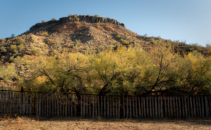
Rustic corral fence with desert bluff and trees at Palmerita Ranch in Arizona.
Corral Fence at Palmerita Ranch Bluff – This rustic corral fence, silhouetted against the rugged bluff of Palmerita Ranch, captures the spirit of Arizona’s ranching legacy. Framed by desert vegetation and illuminated by the warm light of the setting sun, the scene speaks to the enduring harmony between nature and history along the Santa Maria River.

Nearly three years after limping the Turd home from a Las Vegas dealer, it finally earned a new set of shoes. The Turd—our trusty but unglamorous RAV4—had been rolling around on a mismatched set of tires so cheap they probably doubled as floaties in their previous life. The dealer, ever the bargain artist, slapped two new tires on the front and waved off the rears, claiming they were “good enough.” Good enough for what? Ice skating?

Now, I’ll admit, I’m a cheapskate. No, wait—cheapskate is too generous. I’m a cheap-sketeer, proudly waving my coupon flag while riding into battle on a discounted steed. Queen Anne was already less than thrilled about buying an SUV in the first place, so I figured, why spend a penny more than necessary? Besides, I was sure those dealer-installed tires would wear out faster than flip-flops at the Grand Canyon. But to my surprise—and annoyance—they wouldn’t die. One year went by, then another, and finally, this fall, I noticed the wear bars creeping up between the treads like a slow elevator. “Yes!” I cheered. It was finally time.

I took the Turd straight to Tony’s Tire-O-Rama, where Tony recommended a set of beefier tires tough enough for Arizona’s backroads. I didn’t want anything flashy—no oversized doughnuts that scream, “Look at me, I’m compensating!” They’re a smidge wider and taller for an extra half-inch of clearance. The result? It’s subtle but satisfying. The Turd now stands a bit prouder, like a French maître d’ with a slight bow, murmuring, “Ho ho, monsieur, you mistake my purpose.” With these new shoes, I finally have the confidence to tackle sandy washes, rocky trails, and all the Arizona backroads where secret treasures are hidden.
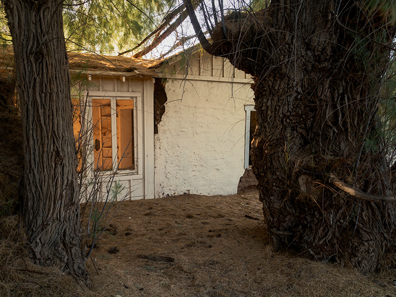

East side of historic adobe homestead at Palmerita Ranch shaded by two large tamarisk trees.
Palmerita Ranch Homestead Shaded by Tamarisk Trees – The east side of the Palmerita Ranch homestead rests in the protective embrace of two towering tamarisk trees, their thick trunks and sprawling branches casting a cooling shadow over the adobe walls. These massive salt cedars, among the largest in the area, tell a quiet tale of resilience, thriving in the arid desert alongside the ranch’s enduring legacy.

Shakedown Cruise to Arizona’s Secret Lake

When I first heard about Palmerita Ranch, a historic homestead nestled in the Alamo Lake area, I knew it was the perfect destination for the Turd’s inaugural off-road adventure on its new tires. Alamo Lake, often called Arizona’s “secret lake” (or perhaps “secret park,” depending on who you ask), sits so far off the beaten path that it feels more like a treasure hunt than a road trip.

The journey began with a drive halfway to Quartzsite, where we turned right at a wide spot in the road named Wenden. From there, we headed north on Alamo Road, threading the Harcuvar Mountains through Cunningham Pass and descending into Butler Valley. I’d only been out this way once before—to photograph a hike in the Mud Cliffs—and I remembered the dirt roads being manageable enough that I didn’t need a tank to navigate them. My main concern this time was the deep sand in the dry washes.

Sure enough, the Date Creek Wash gave us our first test. As the Turd climbed the sandy bank on the far side, I felt a surge of confidence—no need for 4WD here. The extra width and chunky tread on the new tires made light work of the loose sand, even if Queen Anne didn’t quite share my enthusiasm. She grumbled through every bump and rut, reminding me why we call this a “shakedown cruise.”

The real challenge came when we reached the Santa Maria River. The ranch was on the same side of the River as us, but the high bank demanded an entry road that plunged sharply down a rocky, narrow cow path carved into the hillside. The grade was so steep that we couldn’t see the abandoned buildings until we were two-thirds down. Gravel and loose rocks made the descent feel like riding a controlled avalanche. By the time we reached the bottom and prepared for the climb back up, the sun was setting, Anne’s stomach was growling in duet with her commentary, and I decided it was time to engage 4WD to assist. Was it overkill? Maybe. But it got us up the hill faster, and sometimes, survival means knowing when to appease your passengers.

Of course, the entire trip from our house in Congress to the ranch measured precisely 100 miles. Had I been feeling adventurous (read: foolish), I could’ve driven up US 93 for 33 miles and hiked 14 miles down the Santa Maria Riverbed through the Arrastra Mountain Wilderness. But let’s be honest—you know how I feel about hiking.
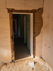

Back door of Palmerita Ranch house with falling plaster revealing adobe block walls.
Back Door of Palmerita Ranch Exposing Adobe Walls—The back door of the Palmerita Ranch house offers a candid glimpse into the home’s construction, where time and weather have peeled away layers of plaster to expose the raw adobe blocks beneath. This weathered detail tells the story of the ranch’s enduring architecture, built to withstand the harsh desert environment and reflect a bygone era of resourceful craftsmanship.

The Hidden Legacy of Palmerita Ranch

The Valenzuela family, who founded Palmerita Ranch in the 1860s, were a remarkable lineage with roots stretching back to Spanish settlers who arrived in California in the late 1500s. Their eastward migration brought them to the Arizona wilderness, where they built a life of resilience and resourcefulness. As ranchers and homesteaders, the Valenzuelas thrived despite the isolation and arid conditions, raising livestock and cultivating the land with ingenuity and determination. Their story is one of courage, perseverance, and a deep connection to the land that still echoes through the ruins of Palmerita Ranch.

Palmerita Ranch sits quietly along the ordinarily dry Santa Maria River, where the water table isn’t far below the surface—a fact betrayed by the towering trees that shade the property. We discovered two homes nestled within a forest of giants during our visit. To the west, Red Gum and White Bark Eucalyptus trees soared over 100 feet, their stature a testament to the River’s hidden life. On the east side, the second house stood under the watchful guard of two colossal tamarisk trees, the largest I’ve ever seen.

A short walk along the riverbank brought us to a small cemetery, now overgrown and untended. Whatever names and dates once adorned the graves have been erased by time and the elements. Still, the site evoked a quiet reverence, hinting at the lives and stories that played out here. A visitor from the 1920s once described fields of alfalfa thriving in the riverbed, used to sustain livestock—hogs, cattle, and goats—that kept the ranch alive.

Though stripped of its comforts, the large adobe house revealed hints of its former grandeur. Its south wall featured large windows framed in flagstone, centered around a fireplace stained with years of smoke, and through the windows stretched a stunning view of the Santa Maria River and the Arrastra Mountains in the distance—a panorama that must have provided solace during the ranch’s more isolated days. Standing within those walls, I could almost imagine living there—if only it had electricity, city water, Wi-Fi, and a grocery store that wasn’t 100 miles away.

Palmerita Ranch may no longer be a working homestead, but its history and place in the Arizona wilderness endure. The soaring trees and sturdy adobe structures stand as monuments to the resilience of the people who once built a life here despite the challenges of isolation and harsh desert conditions. Walking its grounds, it was easy to feel connected to the past and to the enduring spirit of the land itself.
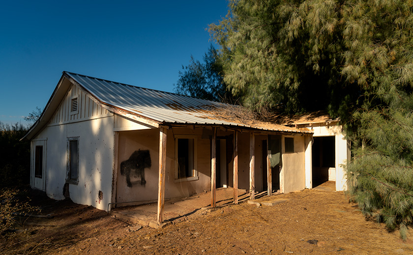

Backside of Palmerita Ranch house with porch and late afternoon sunlight, surrounded by eucalyptus and tamarisk trees.
The backside of Palmerita Ranch House in Afternoon Light – The backside of the Palmerita Ranch house basks in the golden glow of late afternoon sunlight, its rustic charm accentuated by the surrounding eucalyptus and tamarisk trees. This open section of the home offers a rare glimpse of the structure unobstructed by the dense greenery, with long shadows stretching across the weathered porch—a tranquil moment preserved in the Arizona desert.

A Pit Stop for Burgers and Brew

The sun sank low as we started back up the embankment from Palmerita Ranch. By the time we reached the top—after listening to Queen Anne grumble about the constant need to adjust her tiara—I knew we wouldn’t make it home before evening. I stopped the Turd so she could use the mirror to perfect her royal accessories.

“How long’s the drive back?” she asked, still fussing with her reflection.

“Well,” I said, calculating the distance, “long enough to work up an appetite. How about we stop at that bar on the way back and grab a burger for dinner?”

She huffed something indistinct, which I took as an enthusiastic “yes,” so we began the dusty trek toward civilization. Oddly enough, the drive back always feels shorter than the trip out, and before we knew it, we pulled into the Wayside Bar.

Holding the door for Anne to make her grand entrance, I followed her inside and let my eyes adjust to the dim light. The decor was exactly what you’d expect: rusted road trash nailed to the walls, a few highway signs, animated beer lights flickering halfheartedly, and dollar bills covering the ceiling like a green constellation. It reminded me of the Pinnacle Peak Patio at Riata Pass, the first place I’d ever seen that particular motif.

At the far end of the room sat a row of cowboys, their white hats lined up brim to brim along the bar. It felt like a scene straight out of Charlie Daniels’ Uneasy Rider. We grabbed a couple of stools at the other end, strategically positioned with a clear view of the door—just in case.

The barkeep came over and asked what we’d like. Anne ordered a Chardonnay, and I went for the only beer on the list that didn’t have “lite” tacked on it. When it arrived, Anne’s wine was served in a Welch’s grape-jelly glass. She was just about to object when I quickly clamped my hand over her mouth, sparing us both a lecture about proper stemware. My beer followed in—what else?—a frosty mason jar. High-class all the way.

We ordered a burger to split, piled high with jalapeños and enough sauce to make it slide apart at first bite. And fries. Lots of fries. Out there in the dirt, even a roadside burger tastes gourmet. We devoured it like we hadn’t eaten in days, which was a slight exaggeration but not by much. Naturally, I ended up with all of Anne’s peppers, so my half of the burger packed more punch.

When the barkeep returned to ask about dessert, I opened my mouth to remind Anne of the fresh-baked goodies at home. But before I could say anything, she politely declined, asked for the check, and whipped out her credit card to settle up. You could practically hear a record scratch. All along the bar, cowboy hats tilted slightly as they saw Anne paying. I was too busy mentally rehearsing my next line to notice the collective eyebrow lift.

As the bartender returned the card, I leaned over, channeling my manliest voice. “Are you ready to go…cupcake?”

The reaction was immediate. At the far end of the bar, the cowboys snapped their heads around so fast their hats created a breeze. Silence followed, then synchronized laughter erupted like a perfectly timed punchline. The catcalls started as we slinked toward the door, Anne’s tiara slightly askew. The long, quiet ride home was all the sweeter for the fresh-baked dessert waiting for us—though the real treat might have been the memory of that moment.


Final Thoughts

Thanks for coming along on our journey to Palmerita Ranch! We’d love to hear your thoughts—whether it’s about the ranch’s history, your own funny bar story, or anything else you’d like to share. Your comments always make these adventures more fun and meaningful.

If you’d like to see larger versions of the images from this trip, please stop by the New Work section of our website. They’ll be there for the next three months until fresh troops take their place. And don’t forget to join us next month as we set off on another dusty trail, chasing adventure, stories, and, of course, more unforgettable moments.

Until then, may your roads be smooth, your tires chunky, and your humor as dry as the Santa Maria River.
jw

Holbrook Chronicles: A Quirky Journey Through Time and Asphalt Picture of the Month - Holbrook, Arizona

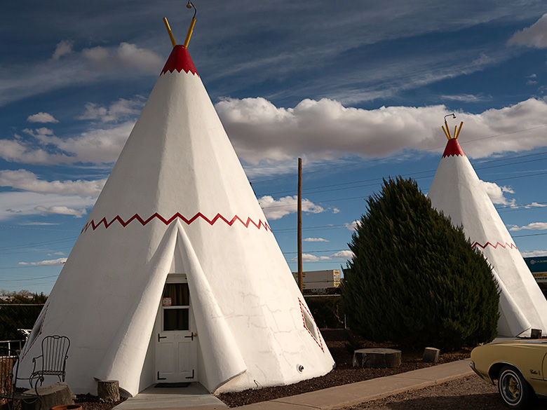
White tee pee-shaped motel rooms with classic car parked outside on Route 66 in Holbrook, Arizona
Nostalgic Nights: The Historic Tee Pee Motel of Route 66 – Step back in time with a glimpse of the historic TeePee Motel on Route 66 in Holbrook, Arizona—where classic cars and unique accommodations summon the spirit of America’s golden age of road travel.

Earlier this year, in a fit of cartographic embarrassment, I noticed my Arizona map was as barren in the northeast corner as my understanding of quantum physics. We use the map to bookmark locations we’ve visited and shared with you. “We must address this travesty,” I declared, or perhaps just thought loudly. Thus, Queen Anne and I embarked on an expedition to Holbrook, a place as famed for its petrified wood as my living room is for lost remote controls.

Upon our grand arrival in Holbrook, it became immediately clear how the town’s history was as layered as my attempt at a seven-layer dip, which never made it past layer three. From the ancient trading routes that seemed slightly busier than my last garage sale to the modern buzz of I-40, which promised the thrill of gas stations and fast food, Holbrook whispered tales of change. And by whispered, I mean it mumbled incoherently, much like Uncle Ray after his third Thanksgiving cocktail.

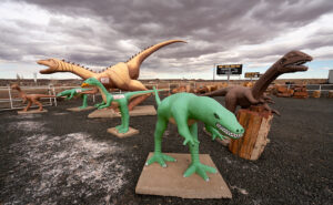
Wide-angle photo of playful dinosaur sculptures in a rock shop yard in Holbrook, Arizona, with petrified wood for sale
Petrified Pals: The Dinosaur Ambassadors of Holbrook’s Rock Shop – Encounter the past in a playful panorama with Holbrook’s roadside dinosaurs, a nod to the rich paleontological history unearthed at the nearby Petrified Forest National Park.

Diving into the town’s lore, we uncovered tales of early Pueblo peoples, whose idea of commuting was traipsing along the Little Colorado River. They traded goods with the enthusiasm I reserved for exchanging unwanted Christmas gifts. Picture them, settling down by the river’s edge, not to snap sunset selfies, but to swap stories of Coyote, the original trickster who probably invented the concept of “fake news,” and Spider-Woman, the ancient weaver who, unlike me, never blamed her tools for a botched job.

Then came the white men, striding into the horizon with all the subtlety of a brass band in a library. With their grand plans to connect coasts, Lieutenant Whipple and Edward Beale undoubtedly paused to ponder, “Will there be sufficient parking?” Their surveying tales were likely less about the awe of uncharted lands and more about the days when their socks stayed dry.

Early Settlement

In 1876, Mormons fleeing the excitement of Utah found solace in what would become Holbrook, a place that made their former home seem positively Las Vegas-esque in comparison. By then, the town had started to take shape, much like my attempt at sourdough during lockdown—full of hope but ultimately flat.

Our foray into this historical mosaic first led us to the part of town that had seen better days. “I’m not getting out of the car,” declared Queen Anne, with the determination of someone guarding the last slice of pizza. And who could blame her? The charm of the Arizona Rancho and the Bucket of Blood Saloon was as evident as the potential in my high school yearbook photo—present, but requiring a generous imagination.

Pedro Montaño built the Arizona Rancho home here between 1881 and 1883. It started as a single-story plastered adobe building with a high-pitched roof and dormer windows. After it was sold to the Higgins family, it became the Higgins House—a boarding house with a two-story addition. Next, it became the Brunswick Hotel. In the 30s, the west wing was used for Holbrook’s hospital, and during World War II, the Navy leased it to house pilots training at the airfield north of town. Now, it’s listed on the National Historic Registry and appears to be undergoing renovation.

Crossing the street from the train depot is another historic building in decay. It was initially called Terrell’s Cottage Saloon, and it was popular with cowboys and ruffians. After a violent gunfight in 1866 that ended up with two men dead, the street was described as if someone had poured a bucket of blood on it. The name stuck, and the saloon and street name bear the moniker. When we visited, a prominent sign urged people to contribute to saving The Bucket of Blood Saloon.

Imagine Holbrook as the Wild West’s version of a reality TV show, complete with outlaw gangs and cattle thieves vying for the title of Most Wanted, starring the Hashknife Gang and the Blevins Brothers, with special guest appearances by the Clantons, who thought the Earps’ version of justice was a tad too personal. Enter Sheriff Commodore Perry Owens, Holbrook’s answer to a sheriff who didn’t just wear a badge but practically invented the law enforcement genre with flair. His Wikipedia page? It’s the binge-worthy history lesson you never knew you needed.

Traffic Increases On Route 66

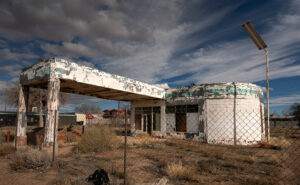
Faded green signage on an abandoned gas station under dramatic sky in Holbrook, Arizona
Deserted Drive-Up: The Withered Gas Station under Holbrook’s Sky – Behind a chain-link time capsule, the remains of what could be a Sinclair station stand sentinel under the vast skies of Holbrook, a mute testimony to the bustling days of Route 66.

Holbrook thrived on a cattle economy akin to a bovine social club for decades until 1926 rolled around with Route 66, flipping the script. Suddenly, Americans, intoxicated by the freedom of their Model Ts, were gallivanting across the country, pioneering the original road trip minus the luxury of air conditioning or reliable GPS. The Dust Bowl era added a gritty reality show twist, turning Route 66 into the “Mother Road” of all escape routes. By 1938, the road’s complete paving made cross-country jaunts less of a teeth-rattling affair, shifting Holbrook’s social scene north of the tracks. The town’s once-thriving pit stops turned into a ghostly strip of nostalgia, save for the Tee Pee Motel, now a restored relic where vintage cars outnumber guests—missing the chance to sleep in a concrete teepee? Now, that’s a modern regret.

Post Interstate 40

As Holbrook entered the fast lane of the Interstate 40 era, it seems the town, like a bewildered tortoise at a Formula 1 race, was sidelined by the rush towards efficiency. Where once adventurers might pause to marvel at the local color, they now zoom towards the neon glow of franchise signs, seduced by the siren call of combo meals and loyalty points. It’s as if America’s highways have become conveyor belts, whisking travelers from Point A to B with little regard for the stories and spectacles they blur past.

Amidst this homogenized landscape, Holbrook is a defiant reminder that sometimes the best part of the journey is the quirky diner you didn’t expect to love, not the time shaved off your ETA. In rediscovering Holbrook, we find not just a town but a treasure trove of tales begging us to slow down, look around, and maybe, just maybe, find a piece of ourselves among the echoes of Main Street. So, let’s take that exit ramp less traveled; who knows what stories await among the faded signs and whispers of yesteryear?

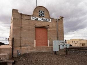
Old Holbrook train station sign with Santa Fe logo on a building repurposed as a warehouse along the railroad tracks
Tracks to the Past: Warehouse Days at Holbrook’s Old Depot—Standing with silent stories, the repurposed Holbrook train station along the SP tracks endures as a storied warehouse among the town’s architectural relics.

I hope you enjoyed our Holbrook tale and viewing the new photos. If Queen Anne and I have piqued your interest, you can see larger versions of this month’s adventure in my New Work collection <Link> and Fine Art America page <FAA Link>. They’ll be there for the next three months before they make way for a new adventure. Be sure to return next month when we stop at the Painted Desert and Petrified Forest.

Until our next detour, may your travels be full of discovery and stories as rich as Holbrook’s past.
jw

Cool Springs Route 66: Relics and Flags Picture of the Week - Oatman, Arizona

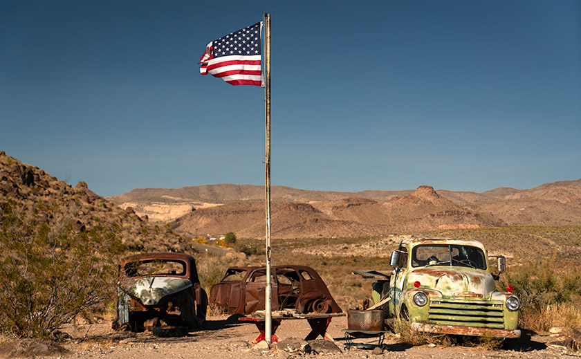
Vintage cars parked under a waving American flag at Cool Springs Station on Route 66, Oatman, Arizona.
Cool Springs Route 66: Relics and Flags – Echoes of the Past: Vintage cars sit silently under the vibrant hues of the American flag at Cool Springs Station, capturing the enduring spirit of Route 66.

The things you do for love. We don’t often get company, but when we do, Queen Anne transforms into a machine as she attempts to disinfect the house from top to bottom. My best chance of staying out of the trash bin or sucked into one of her vacuums is to lock myself in my office. That’s what happened the first week of December. Anne’s sisters came out for a long weekend visit, meaning that she spent the entire month of November scrubbing the walls. She only put down her Comet can for our traditional Thanksgiving dinner at Denny’s.

Before leaving to pick them up from the airport, imagine my surprise when she handed me a crisp $20.00 bill and told me, “Find someplace to spend the night.” It was predictable because we haven’t had enough beds for multiple guests since we sold our Casita (don’t remind me). I decided to drive over to the river and lose my newfound wealth on the Craps table. Since I was going in that direction, I thought I could get some Route 66 shots. And there, my friend is the story of how Oatman became January’s photo project.

In Arizona, there are two long stretches of the original Mother Road. The first and longest is the Seligman – Peach Springs – Kingman section. The other runs from Kingman, through Sitgraves Pass, to Oatman, and then the old bridge crossing the Colorado River. Since I have very few photos of Oatman, I took this route on my way home from Laughlin. I’m glad I did.

The only other time I drove this section of Old Route 66 was during the pandemic. At the time, we were avoiding people, so we didn’t stop to shoot any roadside attractions. However, the Cool Springs Station burned a hole in my lens, so it was a required stop on this trip.

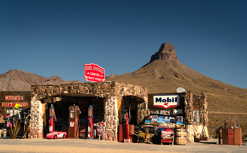
Cool Springs Station and vintage gas pumps along Route 66 with Thimble Mountain in the background in Oatman, Arizona.
Cool Springs: Route 66’s Desert Jewel—Step back in time at Cool Springs Station, an iconic stop along Arizona’s stretch of Route 66, nestled against the majestic backdrop of Thimble Mountain.

You’ve likely seen pictures of this place in books or videos about Route 66. With its classic shiny red Mobil gas pumps (there’s a rusty one, too), it’s a perfect backdrop for motorheads to snap a portrait of their car. It hasn’t always been this gleaming jewel on the Mohave Desert floor. It has a history.

Nestled against the rugged backdrop of the Black Mountains, Cool Springs Station has stood as a silent witness to the ebb and flow of Route 66’s storied past. Established in the mid-1920s, Cool Springs was built to serve the burgeoning car culture of America, providing fuel, refreshments, and a welcome respite to weary travelers making their way through the Sitgreaves Pass. Its distinctive stone façade and gleaming gas pumps quickly became a symbol of the optimism and adventure spirit embodied by the Mother Road.

However, the passage of time and the shifting sands of progress were not always kind to Cool Springs. In the late 1960s, as the new interstate system redirected traffic away from Route 66, the station saw a decline, eventually falling into disrepair and was nearly forgotten. It wasn’t until 2001 that Ned Leuchtner, a Route 66 enthusiast, recognized the cultural and historical importance of Cool Springs. He undertook the painstaking task of reconstructing the station, using vintage photos as his guide to ensure authenticity. Today, the station has been restored to its former glory, complete with those classic red Mobil gas pumps and the original stone masonry, standing as a tribute to the enduring legacy of Route 66.

My picture of the month isn’t of the station but the yard art off to the side. The image is a trio of old car shells clustered under an American flag, with the Black Mountains as a background. Although these vehicles are historic, if they had any value, some collectors would have snatched them long ago.

The flapping flag is what made me choose this week’s photo. I shot this midday with lighting that blends the cars and mountains into a bland porridge. The flag becomes the image’s star. It’s almost like the flags that fly over our national cemeteries. The picture says, “These are the fallen heroes of the long Route 66 history.”

We’re tickled that you started this year by spending time with us. If you want to see a larger version of this month’s photo, they are online on my website < Jim’s Page> and Fine Art America <FAA Link>. If you want to buy the Chevy Truck, you can contact Uncle Jim’s Cherry, One Owner, Used Car Emporium by leaving a comment below.

We look forward to your comments, so don’t be bashful. We’ll return with more Oatman and Route 66 photos next week, so don’t touch that dial.

Till then, keep your spirits high and your humor dry.
jw

Techniques: Waiting for the decisive moment.

You might think snapping a flag is a breeze, but let me tell you, it’s more like herding cats on a windy day. I aimed for a balance—not too limp and not overly taut—to convey a sense of movement and life. This required patience and timing, like capturing the peak moment in sports photography. With the wind’s whims as my conductor, I played a game of red and green light, waiting for Mother Nature’s perfect cue—talk about being at the mercy of the elements. In retrospect, a tripod would have saved me from the armache of holding steady through the breezes.

For the technically curious, this was a dance of light and speed. I shot in Aperture Priority mode with an f-stop of 6.1, relying on the bright midday sun to provide a fast enough shutter speed. My main concern was keeping the truck headlights and the flag’s stars and stripes in sharp focus. Choosing the correct f-stop or waiting for the wind is like deciding on the right spice for a stew or the right socks for sandals—not always obvious, but oh-so-important!

WPA Legacy: The Historic Cattle Dam of Gold Butte Picture of the Week - Mesquite, Nevada

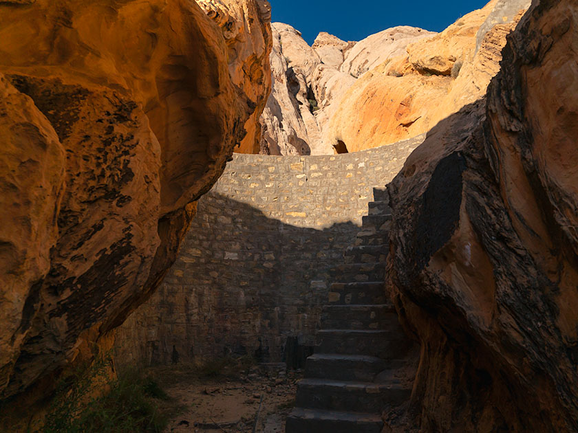
WPA-built stone dam between rock formations in Gold Butte National Monument, captured by Jim Witkowski.
WPA Legacy: The Historic Cattle Dam of Gold Butte – Stepping Through Time: This WPA-constructed dam at Gold Butte stands as a rugged monument to past endeavors, harmonizing with the arid beauty that surrounds it. A silent witness to history, its stones speak of a bygone era of hope and hard work.

Victorious in my quest to capture the ancient whispers etched into stone, I returned to our trusty steed, the Turd. There, amidst the dust and echoes of bygone civilizations, sat Queen Anne; her latest book–escape, concluded. Her gaze met mine, an unspoken dialogue of adventure’s end, punctuated by a brief, ‘Can we go now?’ Her tone carried the weight of a royal decree, yet I knew the kingdom’s treasury of wonders still had one gem left to unveil.

At the end of the infamous paved road, you can turn south towards the abandoned town of Gold Butte or go straight towards the Arizona border and the Grand Canyon—Parashant National Monument. Both roads are equally evil to drive on, but I wanted to find another relic of history—a WPA-era dam, so I started east. We didn’t travel far because I spotted a cistern on the left as soon as we drove through the first dry wash. I pulled the truck over and grabbed my camera.

The cistern looked like a dry concrete bathtub, and a rusty pipe beckoned from the cistern to a narrow canyon on the right. A couple of creosote bushes blocked the view (and the path), so I brushed them back with my arm and saw the dam. It looked like a scale model of the Hoover Dam 50 miles downstream. Although it was built in the 30s and no longer maintained, it looked like it would still hold water if you closed the gate and valves. It is another testament to those folks’ work during the Great Depression.

After getting some shots, I wanted to see how deep the backside was, which meant climbing the stairs. In my younger days, I would have said, “Nothing to it,” and jogged up the stairs. But there’s no handrail, and my balance isn’t the same, so I did it the hard way—backing up one step at a time while sitting on my butt. I got my dose of vertigo and started back down the stairs when three outdoorsmen walked through the slot. My face turned red, and I apologized, “Sorry guys, this is how we geezers climb stairs these days.” One of them quipped, “We understand—Mister Girly-Boy.”

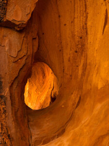
An erosion-formed window in a sandstone canyon wall, illuminated by sunlight at Gold Butte, photographed by Jim Witkowski.
Nature’s Art Frame: The Erosion Window of Gold Butte -Carved by the patient hands of time and elements, this erosion window in Gold Butte’s canyon wall frames a story millions of years in the making—each layer a verse in earth’s grand narrative.

This week’s other photo is of a natural erosion window along the canyon’s narrow. Unless you’re the stature of our friend and frequent commenter, Deb Poteet, you can frame your face with it by standing on your toes. As usual, Anne wouldn’t get out of the car, so I had to settle for shooting the opening without her pretty face. Still, it’s pretty cool.

In the mirror

Queen Anne and I covered a lot of ground this year. We visited two California Wine regions without being tossed out on our ears. We followed some of our favorite trails and got reacquainted with the charming cities of Bisbee, Tombstone, and Douglas. We explored the Beeline Highway and the Mazatzal Mountains, shot wildflowers in the spring, got caught in a monsoon storm at sunset, and discovered some fantasy shapes in Prescott’s Granite Dells City Park. With pandemic restrictions lifted, we did a decent job of broadening our range and bringing you more diversity with this year’s photos and stories.

This has been a year of growth for us. I’ve tried to improve my writing skills. I completed a couple of online creative writing courses. You’d think it would make my work more manageable, but it didn’t. What I used to knock out on a Sunday morning now takes me three days of writing, editing, and revising before I’m ready to publish. I also invested in a grammar checker that—hopefully—gets most of the commas in the right places.

I’ve been tinkering with my photo processes by watching online photographers. I picked up some new tips and tricks, which I’ve tried to pass along to you in the Techniques section. I think you found them helpful because I’ve received positive feedback from you. Finally, to attract new subscribers, we started producing monthly YouTube videos. In each of the last few months, I converted one of my static portfolios into a five-ish-minute video with music and voice-overs. With these new videos, we’re blending the old-world charm of static images with the zippy excitement of moving pictures—without the smell of darkroom chemicals. It seems to be working because my web traffic is on the rise.

Through the windshield

I have an Arizona wall map on our laundry room wall with colored dots indicating the places we’ve visited in the last couple of years. Instead of being evenly distributed, two empty spots glare at me from the map. The first is along the southern border between Nogales and Yuma. Since that’s restricted chiefly to military ranges, there’s not a lot I can photograph without starring in my impromptu sequel to North by Northwest. The other section is the northeast corner of Arizona—the Navajo and Hopi reservations. I intend to paste a dot or two in that corner next year. Maybe you could suggest some locations.

There’s more to discover at Gold Butte National Monument. I plan to return this spring if the Turd’s crummy tires ever wear out. Getting stuck out there without communication is a genuine concern for us. Some sights we missed this year include Devil’s Throat, the remains of Gold Butte’s ghost town, and Little Finland.

Finally, next year’s wine region adventure will be in Northern California. Will it be Napa, Sonoma, or the Russian River? Let us know where your favorite California wine comes from. We haven’t picked a winner yet, but the trip will be in August. As Samuel Clements once said, “The coldest winter I ever spent was a summer in San Francisco.” Some dispute that the quote is genuine, but for us desert dwellers, it’s a challenge.

Queen Anne and I wish you a very happy and prosperous New Year. We hope you’ll continue joining us on our escapades and maybe invite some friends. We’re always delighted to see you in the back seat. Feel free to share your New Year’s adventure plans in the comments below. They give us ideas for which roads we take.

Till next time, keep your spirits high and your humor dry.
jw

BTW:

Last week, I released my latest YouTube video based on my portfolio of pictures of California. It’s five minutes of eye candy, and I invite you to see it by using this link: [https://youtu.be/cgXAHPyzQ5Y]

Sculpted by Time: Whitney Pocket’s Sandstone Wonders Picture of the Week - Mesquite, Nevada

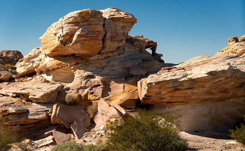
White sandstone rock formation at Whitney Pocket, similar to Zion National Park, in the Gold Butte area of Nevada.
Sculpted by Time: Whitney Pocket’s Sandstone Wonders – Amidst the rugged beauty of Whitney Pocket, this layered sandstone formation stands as a silent witness to the artful touch of natural forces, its contours and colors a desert echo of the famed cliffs of Zion.

Before we even packed the Turd for our Nevada trip, I studied all of the Whitney Pocket YouTube videos I could find like they were a final exam. Packing the Turd for the trip felt a bit like preparing a stubborn mule for a mountain trek—full of hope but expecting surprises. When the morning of our exciting adventure finally came, I had my checklist ready. After a hardy breakfast at Peggy Sue’s Diner, we topped off the gas tank and checked the tires. Part of these exercises was taking precautions and waiting for the visitor’s center to open so that we could buy maps and get free first-hand advice.

The people who answered our questions and the Friends of Gold Butte group volunteers were constructive. With a lack of park rangers, they’ve stepped in to fill that role. After reassurance that my SUV would be capable of the drive, the guide offered one last bit of advice. “Be sure to tell someone where you’re going and when you expect to be back. No cell phone coverage exists, and you could be alone out there.” Anne and I glanced at each other, wondering who we could call—we were alone in Mesquite and didn’t know anyone in town. We decided to call her sister—Jane— in North Carolina and panic her, “If you don’t hear from us by 6:00 pm, call the police.”

After the long drive on the awful road I complained about last week, we made it to the end of the pavement—Whitney Pocket. When I first got out of the truck, I felt disappointed. With our backs to Virgin Peak, we scanned the southern horizon, which went on forever in the clear, dry Mohave Desert air. Except for a few lumps of sandstone close by, there was just a sea of yucca and creosote running endlessly downhill to a thin line of blue, which we identified as Lake Mead. Where were all the majestic sandstone formations in the videos I watched?

We were here, and I would make the best of it. Our map showed a petroglyph site three miles down a side road that we passed, so I drove a quarter mile back and started down what I jokingly call a road. The road was passable, but only if I kept the speed under ten mph. The Turd’s front sub-chassis sounded like it was about to fall off as we dodged the football-sized pavement rocks. In comparison, the entrance road was a freshly paved Interstate.

As promised, there was a parking area with a kiosk and pictures at the three-mile mark. Go to the right and see the Falling Man petroglyph, but there would be a large panel of petroglyphs if I went in the other direction. The guide told us that the Falling Man was a longer hike and tricky to find, so I set off toward the easy shot while Anne and her Kindel kept each other company.

After a half hour of scouring the rocks for rock art, I realized I had missed the trail, was lost, and needed to find my way back to the truck. The trail had been pronounced, so I don’t know how I messed up. I started the hike back using my old tried and true method: ” This looks familiar.” I noticed the rock colors and layers as I searched for the trail. They’re more subtle and muted than you find in Bryce or Zion—almost a pastel quality. Then, I crossed over the surface stone patch and found my trail. I stopped, looked around, and discovered that the trail zigged right while I went left. Ah, the old let’s lose the geezer on the hardscrabble trick.

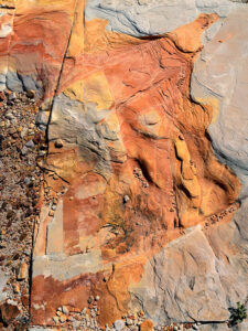
Water or ice erosion exposing red sandstone layers beneath the surface in Whitney Pocket, Gold Butte area.
The Art of Erosion: Exposing Whitney Pocket’s Hidden Hues – Nature’s artistry on display: The intricate dance of erosion carves through time, uncovering the fiery red heart of sandstone beneath the desert’s sunlit canvas.

Now that I was un-lost, I started taking pictures of the stones and capturing the muted colors washed out with the early afternoon sun. My trip back to Anne and the truck was more deliberate as I spent more time shooting and exploring along the way. As we drove away on the rock road, I turned to Anne and said, “I don’t think we should risk running the Turd down these roads until we get new shoes for him.” Anne’s ‘Oh, thank God’ was laced with so much relief that I suspected she might start a Thanksgiving parade there.

While the grand formations played hide and seek with our expectations, the true majesty of Whitney Pocket revealed itself in a serendipitous encounter. This week’s photo—Sculpted by Time—captures a lone formation made from the same limestone that capped Virgin Peak (last week’s shot), one that almost seemed to beckon for attention amidst the vast desert. Its white, streaked face looks unremarkable at first, but if you look closely at the lower-right corner of the image, you’ll see a joint (not that kind, you stoners). This is where a layer of the Navajo Sandstone is popping its head from the ground. These are the same petrified dunes seen in Zion National Park, and we showed you in Utah’s Snow Canyon State Park last year. This shot was a dance of light and texture, a moment where time stood still, and the story of the earth was told in a single frame of layered rock.

Here is evidence of rising ancient seas and covering the dunes up. Over eons, the skeletons of shellfish collected on the seabed and covered the dunes with a layer of their own. I think that’s cool, not to mention that I like the natural window in the upper center, too.

Next week, we’ll return to Whitney Pocket, but our focus will shift to the ‘Dance of Light and Shadow’ this time. We’ll explore how the changing sunlight angles transform the sandstone from mere rocks into a canvas of nature’s art. Expect tales of how the sun brings out different personalities in the stones. If you’d like to examine the rock layering closer, you can stop by my Web Page < Jim’s Page> or my post on Fine Art America <FAA Link>.

Till then, keep your spirits high and your humor dry.
jw