Valencia Peak Vista: Capturing the Essence of Montaña de Oro Picture of the Week - Morro Bay, California

Landscape view of Bluff trail winding through grassy field with majestic mountains in the background at Montaña de Oro State Park in California
Valencia Peak Vista: Capturing the Essence of Montaña de Oro – Immerse yourself in the breathtaking beauty of Montaña de Oro State Park as you follow the beautiful Bluff trail, surrounded by rolling grassy fields and towering mountains. Discover this hidden gem’s serenity and natural wonders on California’s central coast.

Welcome back to our San Luis Obispo County project. As I tried to explain last week, it’s one of our favorite spots on the planet. Usually, the purpose of our trips involves wine tasting, so we spend most of our time traveling the roads that run past the vineyards and traverse the coastal mountains—the Santa Lucia Range. With an extra day set aside for photography, Queen Anne and I made a pact to explore places in San Luis Obispo County that were new to us.

On the morning of our shoot—after I dragged her majesty out of bed while we ate breakfast—I showed her a road I found on our California Gazetteer. It began in Morro Bay and made its way along the coast on the Montaña de Oro headlands to Pismo Beach. I told her my plans to drive down to the resort town and then return via the 101 Freeway. She thought that was a great idea as long as there was a candlelight dinner and a glass of Chardonnay at the road’s end. However, halfway through the drive, we found a locked gate preventing us from going further. It turned out that someone built the Diablo Canyon Nuclear Generating Station in our way and closed the road—how inconsiderate.

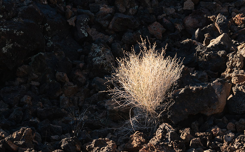
Our day wasn’t a total loss because, between Morro Bay and the gate, we drove through three nature preserves: Morro Bay Estuary, El Morro Elfin Forest, and Montana de Oro State Park. Since we had to double back, I’d have to settle with subjects along our route—oh, pity the poor photographer because each place is worthy of an afternoon—if not longer.

Morro Bay Estuary: A coastal wetland teeming with diverse wildlife and stunning vistas. A network of trails to explore that wind through the estuary offers opportunities to spot various bird species, including majestic herons and graceful egrets. If you remember to bring your mukluks, you may even try digging for clams or annoying the critters you’ll find in the tidal pools.

El Morro Elfin Forest: Unique and magical woodland. Marvel at the twisted, dwarfed trees that named the forest, creating an ethereal atmosphere. Stroll along the well-maintained trails, enjoying the tranquil ambiance and the delicate balance between the forest and the surrounding coastal dunes. Keep your eyes peeled for rare plant species and enjoy the peaceful serenity of this hidden gem.

Montana de Oro State Park: A coastal paradise of rugged cliffs, golden beaches, and sweeping vistas. Hike along the stunning bluffs overlooking the Pacific Ocean, witnessing the power of crashing waves and the dramatic coastal scenery. Explore the tide pools, where you can encounter a fascinating array of marine life, and venture further into the park to discover hidden coves and secret beaches.

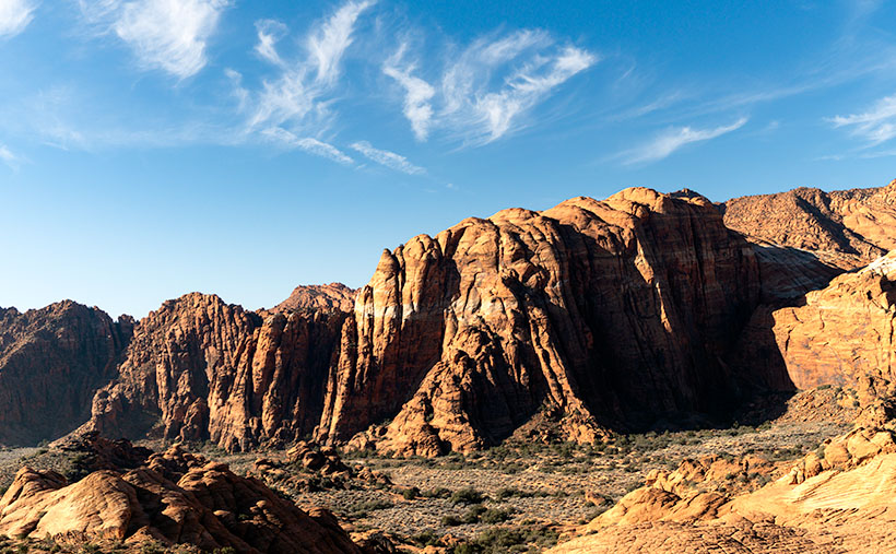
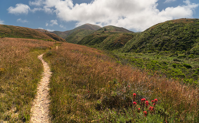
I took this week’s image at the Bluff trailhead in the State Park. From the parking area, we had a choice of taking the trail down to the ocean or venturing across the street to embark on the course that led us into the majestic mountains. As we made our way along the path, the peaks rising to Valencia Peak stood before us, their commanding presence adding a sense of grandeur to the surrounding landscape. Amidst this natural beauty, my attention was drawn to the display of a bright orange Indian paintbrush. I knew that capturing this scene would encapsulate the essence of Montaña de Oro’s breathtaking vistas.

We invite you to visit the web version of this image, where you can view a larger version of Valencia Peak Vista: Capturing the Essence of Montaña de Oro. Immerse yourself in the stunning scenery, the rich colors, and the sense of serenity captured in this image. It’s a visual testament to the beauty in San Luis Obispo County.

Mark your calendars, and come back next week for another captivating tale and image. Until then, keep exploring, keep capturing moments, and remember that every step you take can lead to new and remarkable discoveries.

Till next time
jw

Techniques: Utilizing Leading Lines in Your Photographs

Leading lines such as the trail, the line of peaks, and the swale in this week’s image are powerful compositional elements that add depth and guide the viewer’s eye through the image. They create a visual pathway, drawing attention and creating a sense of movement. Whether straight, diagonal, or curved lines enhance the overall composition and introduce a three-dimensional quality.

These lines don’t have to be literal; the arrangement of objects or elements can imply them. By utilizing leading lines effectively, you can elevate your images’ impact and storytelling potential, inviting viewers to explore and discover hidden depths within the frame.

You can transform a simple scene into a captivating visual story by incorporating leading lines into your photography. Experiment with different types of lines and their placement to create a dynamic narrative within your image. Consider how leading lines interact with other elements and the mood they evoke.

Courthouse Yard The Town Too Tough to Die

Courthouse Yard - The tall brick wall surrounding the Tombstone Courthouse yard conceal the gallows within them
Courthouse Yard – The tall brick wall surrounding the Tombstone Courthouse yard conceals the gallows within them

Whenever I visit Tombstone, it takes me a while to get oriented. But when I see a town map, I understand why. Unlike most communities established in the Mormon Territory of Deseret, the streets aren’t aligned to the compass points and aren’t centered on an intersection named Central and Main. Instead, the town is 45° off the compass; there’s no Central Avenue, and Allen Street substitutes for Main Street. Given Tombstone’s distance from Salt Lake City and its rough and tumble history, I don’t suspect its citizens weren’t concerned about religions.

When I visit the “Town Too Tough to Die,” I consider the OK Corral its social and geographical heart. As I stand on the corner of 3rd Street and Allen and look the town over, I see the streets lined with one and two-story old wooden buildings. They’re either painted in bright colors or left in their natural dull brown finish. The only exception is a block southwest on 3rd Street. There you’ll see a large two-story brick building trimmed on each of its angles with white stones. On top is a cupola festooned with a widows-walk. The first time you see this pearl before the swine, you instantly know it must be important. It was—is. It’s the original Cochise County Courthouse.

It only took five years from the silver find to the OK Corral gunfight. In that brief time, the population swelled to 7,000, and robberies and lawlessness ran rampant. Wikipedia notes, “Except for the Earp–Clanton feud, which gave Tombstone an extremely bad press—from which it has no interest in recovering—citizens gladly accepted the proffered alternative.” The townspeople wanted a change. More importantly, miners had to make a two-day journey to Tucson to file a new claim. In 1881 two historical events happened; the shootout and the state legislature carved Cochise County out of Pima and made Tombstone its seat. The irony of those events and building the courthouse a block away from the Corral the next year isn’t lost on me.

By 1929 the silver played out, and Bisbee became the next boom town. The copper strike there required more men to work the mine. With a larger population, Bisbee won the county seat in an election, and the government offices moved 25 miles down the road. The old courthouse sat empty between 1931 and 1955. That’s when the local historical society took an interest in it. They began restoring and lobbying using local contributions until the Arizona legislature declared it an Arizona State Park.

In this week’s featured image, I call Courthouse Yard, I tried to capture the gingerbread and grandeur of the red-brick building, but I wanted to emphasize the wall surrounding the side yard. Inside those enclosures is where convicted murderers met justice at the gallows. The first hangings were the perpetrators of the Bisbee Massacre in 1883, while the last was the two men that killed a sheriff and deputy at the Wilson Ranch Shootout in 1899. The tall brick walls were designed to shield the gentle public from the gruesome hangings, but most of the town went inside and watched through the second-floor windows anyway. Incidentally, I like the foreboding clouds hanging above the courthouse.

You can see a larger version of Courthouse Yard on its Webpage by clicking here. I hope you’ll join us next week when we tell another thrilling tale from yesteryear in Tombstone.

Till next time
jw

BTW:

We’re planning to visit Temecula, California, wine country, in the upcoming weeks. I hope to bring home a bottle or two along with the pictures and stories we gather.

Lava Grass  Picture of the Week

Christmas, along with the rest of the solstice holidays, is almost over. I hope that Santa brought you something better than the lump of coal I got. Queen Anne is on the couch in her bathrobe and tiara with a box of Kleenex. She’ll be useless until Amazon Prime stops showing Christmas movies. Since we won’t be back before then, we’d like to wish you the best New Year in 2022. Things have got to turn around eventually, so let’s give it a go one more time.

Today, I will finish up the year, and our visit to Snow Canyon State Park by talking about the other rock found there—basalt from recent lava flows. If wind, water, and ice sculpt sandstone, the cooled magma is geology’s Etch-a-Sketch reset button. The black rock covers the softer sandstone and forces water to change course. The runoff carves different canyons, like in the park.

As you explore the park’s north side, you’ll see basalt-covered cliffs. They used to be the canyon floor, but 27,000 years ago, the lava forced the drainage west and carved a new floor—now a couple of hundred feet lower. Snow Canyon has a couple of trails that wander through the jagged black rocks; the Lava Tube and the Cinder Cone trails. The latter is interesting because you can hike to the cone’s rim and look into the extinct caldera. However, the track is uphill, and on the east side of State Route 18, so we skipped it.

Lava Tube - When the magma skin cools and then ruptures, the flowing magma escapes leaving behind a cave.
Lava Tube – When the magma skin cools and then ruptures, the flowing magma escapes leaving behind a cave.

The Lava Tube Trail is shorter,  level, and leads to two lava tubes—which are places where the hardened surface fractures releasing the still molten magma inside to flow away. The remaining caves are sometimes big enough that you can crawl into and see where the bats and spiders live—I’ll pass. The above photo is the smaller tube, and visitors— braver than I—crawl into it.

Lava Grass - A small tuft of grass ekes out a living in barren basalt.
Lava Grass – A small tuft of grass ekes a living in barren basalt.

I find basalt a challenging subject to photograph. It’s like taking a picture of a black cat in a coal mine. To get any detail, you need to over-expose, which washes out the rich depth. Fortunately, and is the case with this week’s picture that I call Lava Grass, there’s enough green lichen growing on the rock to prevent the shadows from completely blocking up.

I feel lucky to have spotted the tuft of dried grass surviving in the barren rock. I concentrated hard on staying upright as I hiked the trail in the early morning. The jagged basalt is not skin-friendly and will likely draw blood if you fall on it. And—silly me—I left my bicycle helmet at home.

You can see a larger version of Lava Grass on its Web Page by clicking here. Next week we start a new year, with a new project in a new location. Be sure to come back and see where the road takes us.

Until next time — jw

Arch and Honeycomb Weathering Picture of the Week

When you were a child and thunder was new to you, did your mother try to console you by explaining that the noise was just God and the angels bowling in heaven? My mom did that. I believed her because she’d never lie to me, and she knew I’d catch her (although I don’t understand why Santa stopped sending me $20 at Christmas when she died). She always told people that I was their peer, although there may be more intelligent children. Well, what her exact words were is, “He sure ain’t the brightest kid in the class.”

Arch and Honeycomb Weathering - inside the cave on the Jenny's Canyon Trail are a natural window and Honeycomb Weathering.
Arch and Honeycomb Weathering -Inside the cave at the end of Jenny’s Canyon Trail are a natural window and Honeycomb Weathering.

This memory comes to mind because I think I’ve captured the scoreboard that the angels used. It’s visible in this week’s picture—the rows of distorted cribbage holes. If one of the bowlers threw a strike, a lightning bolt would cause a tree to burst into flames. Then they’d advance their marker into the next hole. The one that got their rock in the last spot won. It’s that simple.

I did a lot of online research to prove my thesis, but I found nothing. Instead, the experts call this kind of erosion honeycomb weathering. It’s not clearly understood, but it’s an alchemy of rock, salt, rain, freezing, and expansion. You also have to hold your tongue just right while you’re making it. I saw this type of erosion before in Canyonlands National Park when we visited too long ago, so I assume that it’s shared across Southern Utah’s sandstone formations.

This example of honeycomb weathering is in Utah’s Snow Canyon in a place they call Jenny’s Canyon. It’s at the end of a half-mile (round trip) trail near the park’s south entrance, and it was the shortest and the most rewarding of the side trips that we took. The trail leads to a slot canyon in the sandstone, but not the usual slot. Unlike Antelope Canyon near Page—where running water has cut a course into the sandstone—this is one of those stacked dunes (see last week’s picture) with a gap between the layers. Jenny’s Canyon begins as a typical slot, but dead ends in a short cave. I took my shot from inside the cave.

If you think some weird bacteria are growing on the cave walls, let me explain the color. Like wearing a pair of rose-colored glasses, when the sunlight bounces off the red sandstone, it adds that color to the reflected light, and that’s why the back wall seems to glow orange. Other photographers have successfully captured this phenomenon at Bryce Canyon, but I’ve been unlucky so far. “Damn you, Bryce. I’ll get you one day.”

Jenny's Canyon Sky - Because the canyon walls almost touch, the view of the sky is a narrow ribbon in Jenny's Canyon.
Jenny’s Canyon Sky – Because the canyon walls almost touch, the view of the sky is a narrow ribbon in Jenny’s Canyon.

The second image that I included to illustrate my post is the sky from Jenny’s slot canyon. I’ve seen photos like this, and I wanted one of my own. I think the blue against the glowing orange and dark walls look like torn craft paper glued on one another as a collage. I consider it an abstract because it has no story of its own.

You can see a larger version of Arch and Honeycomb Weathering on its Web Page by clicking here. Come back next week to see the next trail that we explored. It’s not far up the road.

Until next time — jw

Stacked Arches Picture of the Week

Queen Anne and I drove out of the Sonoran Desert to the frozen north this week. No, I don’t mean Alaska or even Canada, but the land of young men dressed in white shirt black tie uniforms that ride bikes in pairs and come to redeem your soul—and don’t even bring cookies to sell. Of course, I’m talking about Utah. When we arrived, we found the same weather we had at home. It’s December—what happened to the snow?

Stacked Dunes - Petrified dunes stacked like records in a jukebox for the western wall of Snow Canyon State Pare in St. George, Utah.
Stacked Dunes – Petrified dunes stacked like records in a jukebox for the western wall of Snow Canyon State Park in St. George, Utah.

We made the five-hour drive to St. George specifically for this month’s project. A couple of years ago—after I published my State Route 12 magazine—one of my cronies said, “Have you been to Snow Canyon. You ought to go—it’s beautiful.” I had never heard of it, but I was impressed enough to add it to my destination list after doing some online research.

I love shooting on the Colorado Plateau, which takes up most of Utah and the excess spills into neighboring states. People have even complained I spend too much time shooting there. Much like a wine snob will order a glass of ABC (Anything But Chardonnay). But, the plateau is addictive for me. It’s too easy to get compelling images there, and you all know how lazy I am.

St. George is along Interstate 15 (initially a Mormon trade route), at the western edge of the Colorado Plateau. It’s a pretty community nestled among several mountain ranges, but we’ve never spent time there for a couple of reasons. First, we only passed through to somewhere else, and second, on our honeymoon, I had to stop and buy a tire there … on Sunday … at a Chevron station because the whole state closes on the Sabbath.

The town has changed over the last 33 years; from an agricultural center to a full-blown resort. The downtown, around the Temple, still has an old mid-west charm, but the mansions that line the cliffs and surround Snow Canyon are right out of Aspen, Snow Mass, or Sedona. Utahans see St. George as their Riviera, so there seems to be a rush to build a second home there. The views are essential, so they’re stacking McMansions side by side along the ridgelines. Their views must be spectacular, but from below, it’s vulgar.

In the middle of this wealth and consumption is Snow Canyon State Park. Originally called Dixie State Park, officials created it in 1959 by combining donated BLM land with a $20,000 ranch purchase (sigh). The state later changed the name to honor Mormon elders. You probably have seen it if you’ve watched Butch Cassidy, Jeremiah Johnson, or the Electric Horseman movies. The entry fee is $8.00, and there are over 30 campsites available starting from $30.00 a night.

My first impression of Snow Canyon was, “Gee, this is small.” The north-south road is approximately 11 miles between the two entrances. But, the park floor climbs a thousand feet in that distance, and there are 12 hiking trails along its length. Packed into that relatively small area is a miniature version of the Escalante Grand Staircase. At the bottom is the reddish-orange sandstone layer common to Kanab, and that’s topped with white Navajo Sandstone as you see in Zion National Park. Black lava flows are mixed with the colorful sandstone, and Signal Mountain provides a grand backdrop. There’s enough to photograph within the park’s boundaries to fill a small picture book (hmmm, there’s an idea).

This week’s picture is a teaser. I took it from the park’s top looking south at petrified dunes stacked up like records in a Wurlitzer jukebox, so I called it Stacked Dunes. The dunes are along the park’s west wall and rise a thousand feet above the valley floor. I couldn’t help but dot the sky with some happy little cirrus clouds as icing. Can you blame me?

You can see a larger version of Stacked Dunes on its Web Page by clicking here. Come back next when we show you pictures of the trails we explored (that’s right, I got Anne out of the truck and down a trail). We’ll start at the park’s south for December and work our way north. It’ll be fun.

Until next time — jw