Cup Holders Picture of the Week

I will pause our Snow Canyon State Park tour for a couple of paragraphs so we can run over to the coast. Don’t worry; we won’t have to put up with any of those weird Californians. Where we’re going, they don’t exist yet. We’re not traveling far—maybe a foot or two. However, we are breaking every law in physics to travel back one-hundred-eight million years ago—to the Jurassic era. You can turn around now and take in the Sundance Sea, right here in southern Utah (how old is Robert Redford anyway). Don’t go in the water. Big things in there will eat you like you’re a gummy bear.

Turn back this way and look down the shoreline. Massive dunes—hundreds of feet high—go on for hundreds of miles. Until now, it’s been hot and dry here along the Equator, but the climate is changing. It’s becoming muggier and swamp-like. The oceans are rising, and soon (in geological time), the water will cover the sand and pile more sediment. The pressure on the dunes will bind them into stone—never to be seen again.

Things would have stayed that way, except our stupid captain rammed the North American plate into the Pacific Plate, and there goes the neighborhood. The crash spun us around and raised the Rockies, the Sierra Nevada, and all the other little wrinkles in between. The resulting damage cracked the mantle so badly that volcanoes could form, raising the Colorado Plateau. Then the Californians move in—can it get any worse?

The crash shoved our peaceful little seaside village up a hillside. We no longer live in a basin where sediments collect. Now, our water flows to a place far away. It peels back layers of rock—like an onion when it does. After erosion uncovers parts of the great dunes, we’ll see them again here in St. George, Zion, and north of Escalante. Now they’re as hard as a rock.

Dune Walkers - About the only way you can stay on the Petrified Dune Trail is to go on a guided hike, like these people.
Dune Walkers—The only way to stay on the Petrified Dune Trail is to go on a guided hike like these eight people.

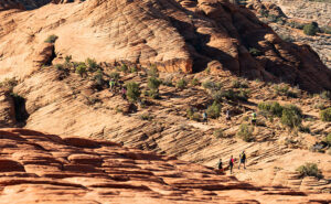
You can snap out of it now and return to reality, where we’re standing on the Petrified Dunes Trail. Because it’s all rock, the only clue you have to follow is the path worn smooth from countless boots. It’s easy to leave it, but that’s fine because you won’t damage anything. The rock grips like sandpaper, making it easy to scramble up and down the slopes. As you wander across the uniformly fractured rock, you examine the exceptions.

Cup Holders - Freezing water bores into the sand stone and will over time reduce the rock to sand grains.
Cup Holders – Freezing water bores into the sandstone and reducing the rock to sand grains over time.

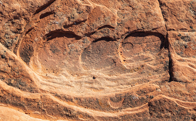
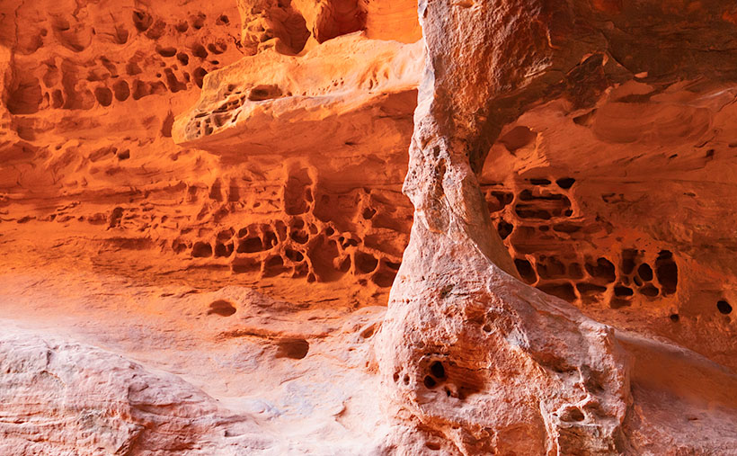
That’s how I found this week’s picture. The round wells in the picture are places where water is collected and has a chance to freeze. As the ice expanded, it fractured the sandstone and chipped it. These spots get deeper; they’ll hold more water and bore into the stone faster. Eventually, they’ll be so deep that they’ll split the block until it reverts to sand grains. I think the shapes of the cups are fantastic, but I like the rich and varied colors in the stone. When you look closely at this, sandstone has a lot of depth and texture.

Click here to see a larger version of Cup Holders on its Web Page. Come back next week when I’ll tell you about how the stupid captain left the kettle on too long and spilled hot lava all over the park.

Until next time — jw

Arch and Honeycomb Weathering Picture of the Week

When you were a child and thunder was new to you, did your mother try to console you by explaining that the noise was just God and the angels bowling in heaven? My mom did that. I believed her because she’d never lie to me, and she knew I’d catch her (although I don’t understand why Santa stopped sending me $20 at Christmas when she died). She always told people that I was their peer, although there may be more intelligent children. Well, what her exact words were is, “He sure ain’t the brightest kid in the class.”

Arch and Honeycomb Weathering - inside the cave on the Jenny's Canyon Trail are a natural window and Honeycomb Weathering.
Arch and Honeycomb Weathering -Inside the cave at the end of Jenny’s Canyon Trail are a natural window and Honeycomb Weathering.

This memory comes to mind because I think I’ve captured the scoreboard that the angels used. It’s visible in this week’s picture—the rows of distorted cribbage holes. If one of the bowlers threw a strike, a lightning bolt would cause a tree to burst into flames. Then they’d advance their marker into the next hole. The one that got their rock in the last spot won. It’s that simple.

I did a lot of online research to prove my thesis, but I found nothing. Instead, the experts call this kind of erosion honeycomb weathering. It’s not clearly understood, but it’s an alchemy of rock, salt, rain, freezing, and expansion. You also have to hold your tongue just right while you’re making it. I saw this type of erosion before in Canyonlands National Park when we visited too long ago, so I assume that it’s shared across Southern Utah’s sandstone formations.

This example of honeycomb weathering is in Utah’s Snow Canyon in a place they call Jenny’s Canyon. It’s at the end of a half-mile (round trip) trail near the park’s south entrance, and it was the shortest and the most rewarding of the side trips that we took. The trail leads to a slot canyon in the sandstone, but not the usual slot. Unlike Antelope Canyon near Page—where running water has cut a course into the sandstone—this is one of those stacked dunes (see last week’s picture) with a gap between the layers. Jenny’s Canyon begins as a typical slot, but dead ends in a short cave. I took my shot from inside the cave.

If you think some weird bacteria are growing on the cave walls, let me explain the color. Like wearing a pair of rose-colored glasses, when the sunlight bounces off the red sandstone, it adds that color to the reflected light, and that’s why the back wall seems to glow orange. Other photographers have successfully captured this phenomenon at Bryce Canyon, but I’ve been unlucky so far. “Damn you, Bryce. I’ll get you one day.”

Jenny's Canyon Sky - Because the canyon walls almost touch, the view of the sky is a narrow ribbon in Jenny's Canyon.
Jenny’s Canyon Sky – Because the canyon walls almost touch, the view of the sky is a narrow ribbon in Jenny’s Canyon.

The second image that I included to illustrate my post is the sky from Jenny’s slot canyon. I’ve seen photos like this, and I wanted one of my own. I think the blue against the glowing orange and dark walls look like torn craft paper glued on one another as a collage. I consider it an abstract because it has no story of its own.

You can see a larger version of Arch and Honeycomb Weathering on its Web Page by clicking here. Come back next week to see the next trail that we explored. It’s not far up the road.

Until next time — jw

Stacked Arches Picture of the Week

Queen Anne and I drove out of the Sonoran Desert to the frozen north this week. No, I don’t mean Alaska or even Canada, but the land of young men dressed in white shirt black tie uniforms that ride bikes in pairs and come to redeem your soul—and don’t even bring cookies to sell. Of course, I’m talking about Utah. When we arrived, we found the same weather we had at home. It’s December—what happened to the snow?

Stacked Dunes - Petrified dunes stacked like records in a jukebox for the western wall of Snow Canyon State Pare in St. George, Utah.
Stacked Dunes – Petrified dunes stacked like records in a jukebox for the western wall of Snow Canyon State Park in St. George, Utah.

We made the five-hour drive to St. George specifically for this month’s project. A couple of years ago—after I published my State Route 12 magazine—one of my cronies said, “Have you been to Snow Canyon. You ought to go—it’s beautiful.” I had never heard of it, but I was impressed enough to add it to my destination list after doing some online research.

I love shooting on the Colorado Plateau, which takes up most of Utah and the excess spills into neighboring states. People have even complained I spend too much time shooting there. Much like a wine snob will order a glass of ABC (Anything But Chardonnay). But, the plateau is addictive for me. It’s too easy to get compelling images there, and you all know how lazy I am.

St. George is along Interstate 15 (initially a Mormon trade route), at the western edge of the Colorado Plateau. It’s a pretty community nestled among several mountain ranges, but we’ve never spent time there for a couple of reasons. First, we only passed through to somewhere else, and second, on our honeymoon, I had to stop and buy a tire there … on Sunday … at a Chevron station because the whole state closes on the Sabbath.

The town has changed over the last 33 years; from an agricultural center to a full-blown resort. The downtown, around the Temple, still has an old mid-west charm, but the mansions that line the cliffs and surround Snow Canyon are right out of Aspen, Snow Mass, or Sedona. Utahans see St. George as their Riviera, so there seems to be a rush to build a second home there. The views are essential, so they’re stacking McMansions side by side along the ridgelines. Their views must be spectacular, but from below, it’s vulgar.

In the middle of this wealth and consumption is Snow Canyon State Park. Originally called Dixie State Park, officials created it in 1959 by combining donated BLM land with a $20,000 ranch purchase (sigh). The state later changed the name to honor Mormon elders. You probably have seen it if you’ve watched Butch Cassidy, Jeremiah Johnson, or the Electric Horseman movies. The entry fee is $8.00, and there are over 30 campsites available starting from $30.00 a night.

My first impression of Snow Canyon was, “Gee, this is small.” The north-south road is approximately 11 miles between the two entrances. But, the park floor climbs a thousand feet in that distance, and there are 12 hiking trails along its length. Packed into that relatively small area is a miniature version of the Escalante Grand Staircase. At the bottom is the reddish-orange sandstone layer common to Kanab, and that’s topped with white Navajo Sandstone as you see in Zion National Park. Black lava flows are mixed with the colorful sandstone, and Signal Mountain provides a grand backdrop. There’s enough to photograph within the park’s boundaries to fill a small picture book (hmmm, there’s an idea).

This week’s picture is a teaser. I took it from the park’s top looking south at petrified dunes stacked up like records in a Wurlitzer jukebox, so I called it Stacked Dunes. The dunes are along the park’s west wall and rise a thousand feet above the valley floor. I couldn’t help but dot the sky with some happy little cirrus clouds as icing. Can you blame me?

You can see a larger version of Stacked Dunes on its Web Page by clicking here. Come back next when we show you pictures of the trails we explored (that’s right, I got Anne out of the truck and down a trail). We’ll start at the park’s south for December and work our way north. It’ll be fun.

Until next time — jw

Starring Queen Anne YouTube Video Announcement

As you all know by now, Queen Anne and I spent August last year so that I could photograph along Utah’s State Route 12 (wrote a book about it—wan’ a see it—here goes). What you didn’t know is that one morning we drive to Torrey for lunch, and we filmed a time-lapse video with a GoPro stuck to Archie’s roof. It took a while, but I finally assembled all the clips into a 14-minute video that I posted on YouTube this morning.

Thor's Hammer And Sunset Point
Thor’s Hammer And Sunset Point – Bryce Canyon is the reason most visitors ever drive SR 12, but the video shows what to see before and after Bryce Canyon.

The video shows all of SR12’s 122 miles, and I spliced in spots along the route that are waiting for you to see and photograph. Queen Anne stars in her YouTube debut that will most likely break the Internet. Finally let me say that although it looks like a mad man was driving, I can assure you that the cruise control was set to the speed limit—of course, that may not absolve me from being a crazy person.

You can see Utah’s State Route 12 on YouTube by clicking here. I hope you enjoy watching it and please share your comments or at least give it a thumb up or thumb down.

Until next time — jw

State Route 12 Project New Publication Announcement

Utah SR 12 Magazine
Utah SR 12 Magazine-84 pages of color photos and stories printed on premium paper and you can buy on its Blurb Page.

There’s exciting news this morning coming from the international headquarters of Jim Witkowski Photography, located in beautiful downtown Congress. You may have wondered why things have been quiet around here for the last six months, or that I didn’t post many photos from our Utah trip last summer. Well, I was busy using that time to compile years of photographs into my new 84-page magazine—Utah State Route 12, and I’m pleased to announce that it’s ready for début.

The project’s theme is about the beautiful places in the Escalante Grand Staircase National Monument. The monument is so vast that it has three management areas: the western Grand Staircase Region, Kaiparowits Region, and Escalante Canyon Region on the east flank. There is only one paved highway that spans them all—Utah’s State Route 12. In this project, I wanted to show that there are beautiful marvels to see along its length, and the road is more than just a gateway to Bryce Canyon.

I plan to release my work in four versions: PDF, Magazine, Book, and eBook. I have completed the first two, which—I believe—should get the most attention, and I’m still working on the second half. It looks like they will be ready by Valentines. (Are you in the dog house and need a gift?)

PDF—this version is best for viewing on your computer, and except for bandwidth, it’s free. It’s ideal for those of you that don’t need more clutter. You can open the file and begin browsing right away or save it to your hard drive for later.

Magazine—this is a 84-page hard copy of photos and text printed on premium stock paper. I’m delighted with how well the images reproduced. The magazine’s cost is $ 22.99 (plus shipping) is admittedly pricy for a periodical, but compared to the book, it’s a bargain. Blurb handles the sales on their secure Website because they print them to demand. That means that there won’t be surplus versions lining birdcage bottoms.

Book—the large (13 x 11) coffee table book is still in progress which sounds simple, but it’s in landscape orientation, so the layouts have to be adjusted. The photos are larger than the magazine’s, and I had more space to embellish the stories. It will be available in softcover, hardback image wrap, and hardback with dust jacket. The price of the book is expected to be under $ 200.00 at most, so I think there will only ever be one edition—my own if Her Highness lets me.

EBook—this will be the last version and will be easy to do because it’s the book reformatted to fit your Kindle. That’s all handled by the computers. I don’t know what it will cost, but it will be ready next month, so keep watching my Books sections. The downside is that with this version, you won’t get the privilege of collecting dust with it.

I’m planning on releasing a new project each year as Queen Anne, and I travel. For this first project, I had to learn the software and build the templates; something that took up development time. Future projects should go from camera to print quicker. Plans for next year’s project are in progress.

You can get your free PDF version and preview the magazine by visiting their Web Page by clicking here. I hope you enjoy viewing them and please leave your comments here and/or on their Blurb page.

Until next time — jw