It’s almost the middle of August. Queen Anne and I got our monthly allowance and paid the bills, but we have a couple of bucks left over and they’re burning a hole in our pockets, so we’re getting out-of-town for a week. The plan is to head for the hills … literally. To be precise, we’re off to Springerville and the White Mountains. Once again we’ll be camping in the trailer, or as my friend, Jeff once said, “We’ll be taking the Mercedes and spending a week in the Ritz.” That joke won’t be funny anymore if we ever get a different truck.
Normally we escape the desert’s heat at the north rim. We love going there because there’s nothing to do. So we pack all of our crap and do nothing for a week … except for sleep in the cool air, eat, snooze, drink, slumber … and then take a nap. That was before we were doing this blog, and there’s no Wi-Fi up there. There’s also no radio, phone coverage, television or any other form of communication … well, maybe smoke signals, but I’m lost without auto-correct.
We picked Springerville — actually, the town of Eager which is next door — because it’s central to a lot of touristy stuff. We found a campground that (in reviews) has decent Wi-Fi, so we’re going to go play Tommy and Tammy Tourist and write about it … just like last summer. Won’t that be fun? I hope you’ll join us.
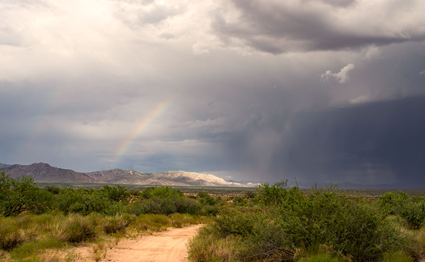
As an afternoon storm moves north, a rainbow touches a peak in the Weaver Range known as Rich Hill. Hmm.
PS: This is a new picture that I put up on my site a few moments ago. I hope you’re not tired of these storm photos because I’m having fun with them. It’s just a phase I’m going through, I’ll get over it.
It was the Wednesday before July 4th and the Lightner Creek Campground and Cabins staff were making preparations for the busy weekend when our friends and fellow camp hosts – Tony and Amelia – raced into the park. This was unusual because the speed limit is 5 mph and camp hosts try to enforce it. They had just come back from town and breathlessly told us that there was a house on fire just east of the campgrounds. We all rushed up the park’s hill to gawk.
It was the house of our, shall we say, interesting neighbor. She lives there with her kids and they regularly shoot off fireworks and guns. On Memorial Day there were loud gun shots coming from there well into the night which made the campground guests nervous. Someone called the sheriff, but the shots stopped before they got there. One of her other neighbors said there were three loud explosions before the house caught fire. The house was burning very quickly and the color of the flames suggested that a gas fueled the flames. Rumors in the community said that she grew pot and processed something more potent in a back room, but we never verified any of that.
As we stood on the hill, we watched the fully engulfed house, when suddenly the fire jumped to the trees and started up the mountain. We all started panicking and using a lot of four letter words. Thank God the wind was blowing away from us.
Amelia – a 911 dispatcher in a previous life – asked if there was an evacuation plan. Robert and Andrea, the owners, fetched ours from office and contacted its creator – the original owner who lives alone at the campground’s west end. She came over, very upset and helped coördinate the evacuation. The plan broke the campgrounds into sections. The owners assigned camp hosts different sections and sent them to their assigned area with instructions for how each campsite should exit. We told everyone to “prepare to evacuate”. It couldn’t have been more than 15 minutes when we got a “MANDATORY EVACUATION” from Code Red – a must have cell phone app. No matter where you are in the USA, it will send you emergency alerts for your area. When the alert sounded, the camp hosts spread out to their assigned areas and began evacuating the campers. Several people were in Durango then, but we made sure anyone in the campgroundsknew they had to leave. After we got the guests out, Deb and I started to hook up our trailer, but before we could, a sheriff showed up in front of our rig and said we had to leave; NOW! So we started throwing stuff in the truck and car and abandoned the trailer. I had time to put in the awnings and turn off the propane, but that was it. A personal evacuation plan for our RV is on my to-do list from now on.
The fire quickly spread after jumping the road. Fortunately, the wind kept it away from the campgrounds.
The campground is in a box canyon and the only way out was down the road toward the fire. The wind was blowing the fire away from us, but it had jumped the road and started up Perins Peak to the north. The fire had jumped across high enough that the road was not blocked. We drove through a maze of fire trucks but finally made it to Hwy 160. We assembled on the side of the highway and wondered what to do. We could see the smoke billowing out of the canyon and flames crawling up Perins Peak. We didn’t know if we would have anything to return to, but we got everyone out safely.
After getting out of the canyon, we gathered at the sided of the road to ponder what to do next.
One of the guests in the group got word that the Red Cross was at the La Plata County Fairgrounds setting up an evacuation center. A seasoned camp host knew where it was, so most of us followed him. Wouldn’t you know it, the fairgrounds booked a rodeo for the holiday and the parking lot was full. Trailers and motorhomes were redirected to the high school parking lot next door. The next day the shelter moved to the Escalante Middle School which had a big parking lot for rigs. The Rocky Mountain Team Black Hotshot fire fighters moved into the fairground shelter. By the way, the Red Cross was great! They provided a place to sleep, water, snacks, and food – donated by various town restaurants.
Deb and I opted for a hotel room instead of trying to sleep in a dormitory full of kids, dogs, and people. When I got on the phone I found out that most of the hotels were booked for the big weekend. I finally found a room at the Holiday Inn, and we spent two nights there until they let us go retrieve our trailer. One at a time, a sheriff escorted the camp hosts in to hook up trailers then get out. The fire was only 20% contained so planes were flying over us while helicopters picked up water from trout ponds close to the road. Some idiot was flying a drone in restricted air space and delayed air operations a day (he was later found and he’s facing charges).
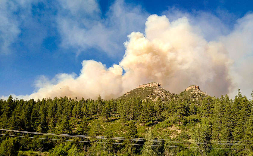
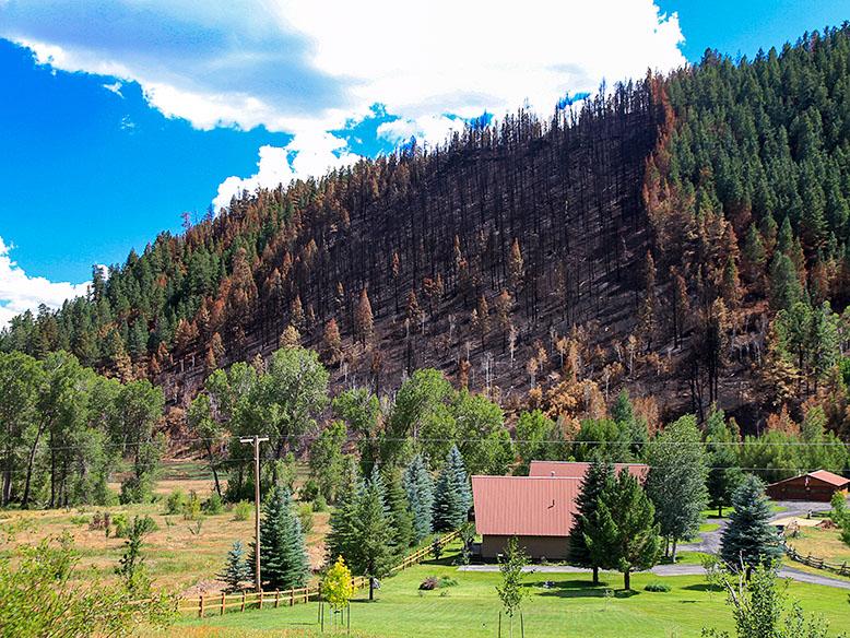
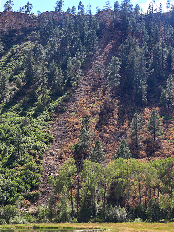
This is the ridge that the fire went up when it first started. The wind blew it over to the other side. This ridge goes right up behind the campground. The burn line runs along the ridge line and the only campground exit was down the canyon and past the fire.
It was a relief pulling our rig out of the park. We headed straight for the middle school parking lot where we dry camped for two nights. The Red Cross commandeered the dining room and they organized a big meeting on the fire’s fourth day with all the players; fire fighters, police, sheriffs, etc. who gave us the status of the fire. Denver TV stations filmed the meeting and we made the evening news. They told us that the fire was still only 20% contained, but they were letting some homeowners return to their homes. Since we were not home owners but were permanent summer residents, officials excepted the camp hosts and they issued us special Rapid Access ID cards. The next day they let us go back to the campgrounds. Whoopee! The road was still closed to the public and we couldn’t take any guests yet, but we were back in our summer home.
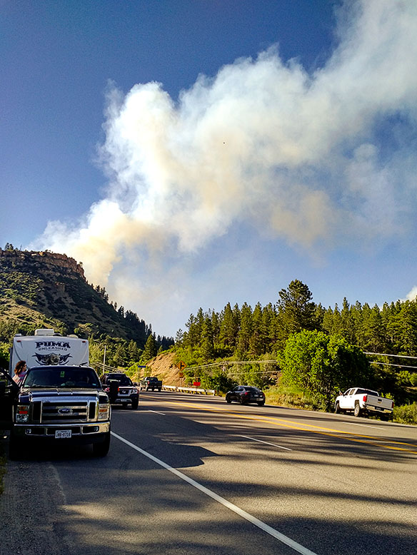
This is where the fire started and continued over the top of the ridge toward Hwy 160. You can see how close the fire came to the campgrounds.
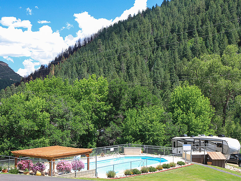
Since we had the campgrounds to ourselves, we threw a 4th of July Bar-B-Que. The campground wasn’t burned at all, and the facilities were fine. The fire came closer than we thought, but it did not cross the boundary. We were very lucky. There were a lot of cancellations for the 4th of July week, but we are now back up to full capacity and it is still a great place to spend the summer.
The morning we got our trailer out there was a line of fire fighters walking in single file to cut that fire line.
They have not identified the reason the house caught on fire, but it was very suspicious. Since the house was destroyed and the fire was so hot, the fire investigators couldn’t find the fire’s cause. As for our interesting neighbor … she wasn’t at home when the fire started, but she did check into the evacuation shelter, so she’s homeless but otherwise ok.
There are a lot of things we’re thankful for when we moved to Congress last year, but shopping isn’t one of them. Sure we have a couple of local grocery stores and merchants nearby that we make do for basics, and there’s always Amazon for the occasional weird stuff we need, but making a Costco run takes days of planning. The stores are far enough away that we plan our trip into town with multiple stops along the route. Shopping at the big box store is an all-day trip.
Our house is conveniently (if you can call it that) located midway between the two nearest stores. We exclude the one in Sun City because it’s impossible to maneuver around the golf carts and inattentive drivers. Our choice is between the Deer Valley store on I-17 and the one in Prescott. The drive time difference is literally five minutes, so the choice comes down to what other errands we need to run. If I need to pick up some hardwood, we go to Deer Valley. If I need something at Harbor Freight, we head to Prescott (for our friends out-of-state, the townspeople pronounce it ‘Press-kit’ and they’re not shy about correcting you). During the summer though, Prescott wins hands down because it’s in the pines and cooler.
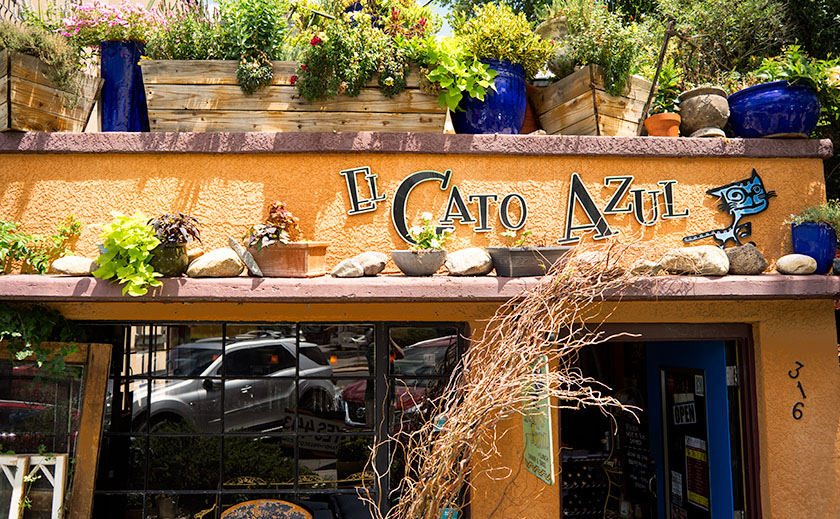
When we make the Prescott run, Queen Anne and I try hard to build in time for lunch, and our favorite place there has become El Gato Azul a tapas place at 316 West Goodwin Street. Goodwin is the street that runs along the south side of the courthouse; the restaurant is two blocks east of Whiskey Row.
Two blocks east of Whisky Row is the tapas bar, El Gato Azul.
The restaurant building is a small one story box on the east side of the Willow Creek trail. It’s smaller than most fast food chains, and the Dijon mustard colored façade has lavender ledges covered with potted plants and lights. The clutter almost obscures the sign.
To enter, you step down from the sidewalk (an access ramp is a few steps to the right) and walk through the bright blue door. Inside the dining room are two . . . maybe three tables and behind the hostess station, an ‘L’ shaped bar fills the rest of the room. The décor is a mix of upscale Goodwill and early garage sale interspersed with canvases from local artists. If you’ve come to eat, (why else would you be there) the host/hostess will escort you back outside through a door on the right. Here is a large covered main dining area that is open in summer, but enclosed with clear vinyl curtains in winter; portable heaters provide warmth.
The food that we expect at El Gato is not what you’d call rib sticking comfort food, but small dishes as you would find in a Spanish tapas bar, but with a southwest influence. It’s more of a tasting menu where you get an interesting burst of flavor combinations in one bite. As with a Chinese restaurant, it’s fun to pick out several items and share. One dish is not enough for a full meal, but the Queen and I fill up by sharing three items. It’s sort of like making a dinner out of a couple of appetizers. Plates range in price from $10-$13 each, so it’s not cheap. They offer a list of soft drinks along with the stocked bar.
One of the meals we enjoyed was their Cajun Corn Dogs. This consists of bacon wrapped tiger prawn fried in corn batter and a glaze of honey.
The next time you travel up Prescott way and you want to try something different, the Queen and I recommend you give El Gato Azul a try. We recommend it, even though Anne is now annoyed with me for letting The Blue Cat out of the bag.
After blowing all our money last year on the Alaska trip, Deb and I thought we were doomed to learning new survival skills for staying all summer in hot Arizona. Then our neighbor, Tom Beavert saved us. He spent his last five summers in cool Durango, Colorado and told us about jobs as camp hosts at the Lightner Creek Campground, so we checked in to it, and got the jobs.
We arrived in the middle of May, just in time for a little snow storm. This was a pleasant surprise after leaving AZ where it was already getting into the 90s. The campground is in a box canyon at 7000 feet elevation. That means the mornings are always cool (40s) and the afternoons are not that bad either (70s or 80s). We work 3 days on and 3 days off, so we have plenty sight-seeing time. It’s really nice staying here for the summer.
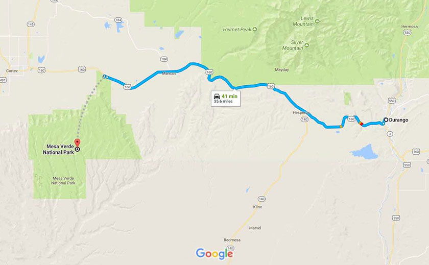
The map shows the highway between Durango, Colorado and Mesa Verde National Park.
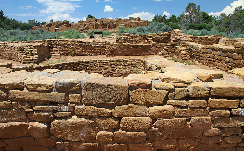
Our first outing was to Mesa Verde National Park, about 35 miles west of Durango. We wanted to visit it before the hot summer set it. When we were dating, Deb and I had stayed in Cortez, CO and had stopped at the park, but only briefly. Hmm . . . I guess we had other things on our mind back then. This time as an old married couple, we saw everything. We spent 4 days in the park and took all the tours. There are a few self-guided tours and plenty of to do on your own, but the best ruins are only accessible via $5.00 guided tours, and because the tours fill quickly, you need to sign up early.
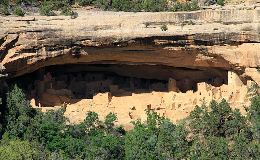
Cliff Palace, the crown jewel of Mesa Verde National Park and an architectural masterpiece by any standard, Cliff Palace is the largest cliff dwelling in North America.
Chapin Mesa is the main visitor center. It’s here you’ll find The Archaeological Museum, Cliff Palace (the largest cliff dwelling), Spruce Tree House, and Balcony House. The tours of Cliff Palace and Balcony House are a must. Balcony House is the most challenging tour. It starts with a climb up a 32 ft. ladder and ends with a crawl through a 12 ft. tunnel on your hands and knees. Believe me; it’s worth it. Allow a day to take both of these tours.
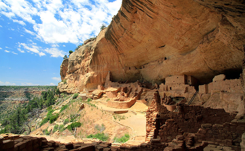
Long House, about equal in size to Cliff Palace, fills an expansive 298-foot-long sandstone alcove from end to end. The village includes about 150 rooms, 21 kivas, and a row of upper storage rooms.
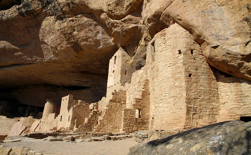
Wetherill Mesa is the “quieter side” of Mesa Verde. It offers a number of opportunities, depending on the season. Mesa Verde is one of the few National Parks that allow bicycling, and on Wetherill Mesa there is a 5 mile loop built for a shuttle bus. The bus was discontinued, so now you can walk or ride your bike on a nice paved road. Wetherill Mesa was my favorite because it was less crowded and had one of the best tours.
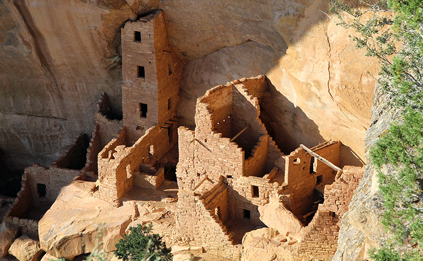
Square Tower House, a beautiful cliff dwelling built-in an alcove in the upper walls of Navajo Canyon. The “tower” had windows, doorways, and flooring, and the inner walls were plastered. About 60 of the original 80 rooms remain.
The Longhouse (the second largest cliff dwelling) tour takes 2 hours and you really get to explore all of it. Step House and Badger House are self-guided tours and you can ride your bike through the Badger House Community Trail. Allow one to two days to see everything on Wetherill Mesa.
Long House, a well-preserved four-story triangular tower rises from floor to ceiling at the far west end of the alcove.
Here is a tip for grabbing a good lunch. Far View Terrace is a nice cafeteria with a gift shop run by the Ute Indians. Their prices are good and the gift shop has a better choice than the Visitor Center. The only other place to eat on Chapin Mesa is Spruce Tree Terrace, near the museum. They are both good, but Far View Terrace is much larger and quieter. We had a wonderful Navajo Taco. If you are going to Wetherill Mesa, they only have a snack bar and a covered patio where you can eat your own lunch.
Far View was a popular place in the early days at Mesa Verde. From A.D. 900 to about 1300, it was one of the most densely populated parts of the mesa. Far View House in the background and Pipe Shrine House were part of the Far View Community.
Don’t forget to pickup the Amateur Photographer’s Guide at the Visitors Center. It is just one sheet, but it has some pretty good advice. It identifies the most photographed areas, the light at different times of day, and suggested locations for shooting. You need a telephoto lens for some overlook locations, but don’t wait for sundown to shoot from the overlooks. The best time is from 5:00 to 6:30 pm to get the most light on the cliff dwellings. Note that high contrast will overexpose parts of your picture and underexpose others. It is best to zoom in on either a dark or light area.
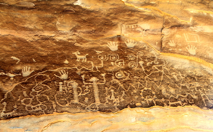
Petroglyph Point Trail, An ancient loop trail starting at the Chapin Mesa Archaeological Museum leads to a petroglyph panel and through scenic wildlife habitat. Hikers must register at the trailhead or museum. The trail is physically challenging and is steep and uneven, with steps, cliff edges and tight passages, and includes strenuousness elevation changes.
We really enjoyed Mesa Verde and now it’s time to move on to our next adventure. We will be exploring downtown Durango and its surrounding area.
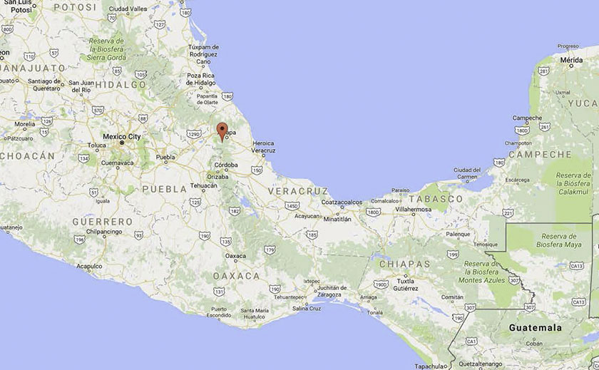
Buenos Dias, mi nombre es Diane Rockerhousen. My husband, John and I live in Xico (hee’ ko), a town of 30k nestled in the subtropical mountains of the state of Veracruz, Mexico. We retired here from Silverton, Oregon, and I’d like to share that story and a bit about our pueblo.
There are three little words that strike terror in the hearts of strong men, “I was thinking. . .” Usually, John slaps a pillow over his head to filter out my next sentence. Eleven years ago with retirement looming on the horizon it was time to write next chapter in our lives; a chapter that didn’t include a large home on an acre of land in rural Oregon, but something smaller, while still having a manageable landscape. First step was selling the house, so we put it on the market in 2007 and didn’t see results until five years later.
We had friends in Oregon that were from the state of Veracruz, and I asked if they had family in the capital city of Xalapa. Silly us, of course they had family there, so I got a one way ticket, and made an exploratory visit. I loved the family, the environs, the climate, and the economy (in our favor), which resulted in us renting a house and beginning the process of moving nearly 3,000 miles south.
Why Mexico? Since John and I had traveled the US and Canada to our satisfaction, we decided to complete the North American trifecta, and head south for a new adventure. Not a day goes by that we aren’t thoroughly confused, entertained or ask ourselves, “Why in hell did we bring that?” After several years of settling in, we’re still happy with our decision. It more than meets our wants and needs
The pueblo of Xico in Veracruz, Mexico
Our pueblo is at the altitude of 4300 feet with an average temperature of 73°F and 66 inches of annual rainfall. It sits nearly midway between Mexico City and the port of Heroica Veracruz on the Gulf Coast.
This area of Veracruz produces a large crop of Arabica coffee that is shipped worldwide. Along with a variety of fruits and vegetables, our pueblo is known for its famous mole sauce (chilies, nuts, fruits and chocolate). If you shop Costco there is a brand named Xiqueno Mole in a jar that our town produces. Allow me to give you a brief tour around the state of Veracruz.
Back in the early 1500’s when Moctesuma (A Spanish spelling variation of Montezuma-ed.) invited Hernan Cortez for a chat, the host served up a chocolate drink with a new flavor that the Spaniard had never tasted. Wanting to impress his guest and possibly keep his head, the Chief shared his secret ingredient . . . vanilla. To anyone’s knowledge then, it only grew in one place, Papantla, and was cultivated by the indigenous community of Totonacas. After years of pillaging and conquering, the Spaniards included some beans and vanilla orchid vines (vanilla panifolia) on their return voyage to Spain. The globe-trotting Spaniards were so enamored with the flavor they tried unsuccessfully to grow it in Asia and then Africa. Many expeditions later they discovered that a small indigenous bee (melipona) was the pollinator and only existed in Papantla. There are stories of entrepreneurs (priests) that built green houses with perfect growing conditions so when the orchids bloomed for only one morning per year, young nubile virgins with feather dusters would go from plant to plant pollinating.
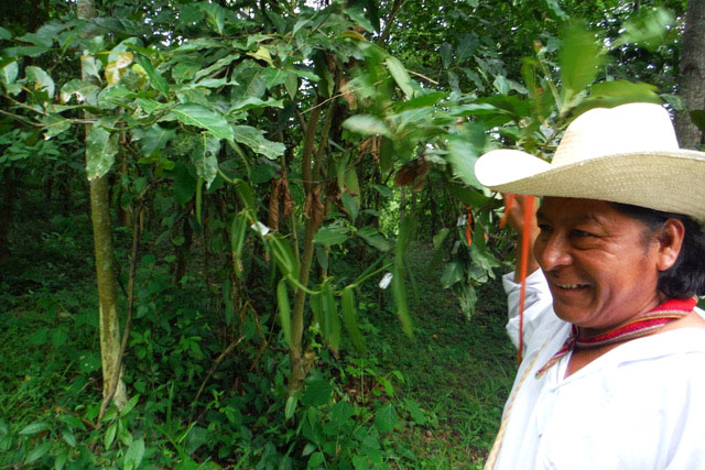
Our guide was a native Totonaca and he reveled the vanilla bean process. (Photo by Laura Henchman)
This man is a native Totonaca who was our guide through the natural orchid forest where you feel a part of the process of providing a product that gives pleasure to so many. The long green beans are the vanilla pods that take 9 months to mature. After harvesting they’re placed in the sun to reduce moisture until they are a mahogany brown and aromatic. At the end of the tour he touches your shoulder to give a Totonac blessing; it is truly a magical place to visit.
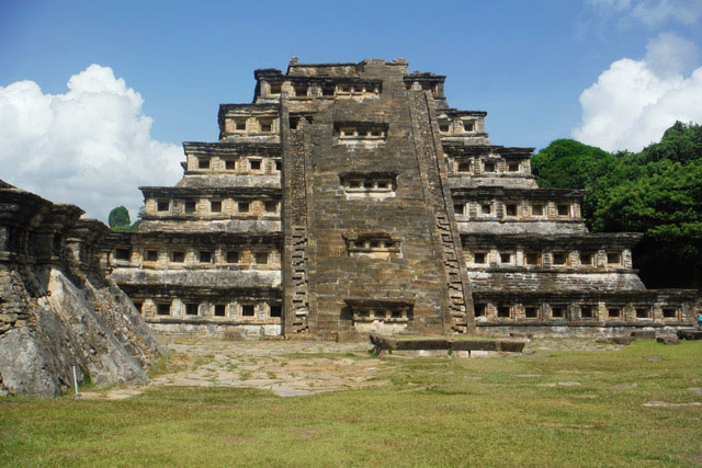
El Tajin Pyramid Site
The El Tajin Pyramid has a niche, or cave for each day of the calendar year. (Photo by Laura Henchman)
El Tajin (600 to 1200 C.E.) is a World Heritage site since 1992, due to its cultural importance and its architecture. This architecture includes the use of decorative niches and cement in forms unknown in the rest of Mesoamerica. The pyramid of the niches has 365 “caves” representing the solar year with a direct connection to the underworld. Similar to post office boxes where you drop off your requests, then wait for the results, good or bad. As a side note, above one of the niches is a sculpture of a ceremony with a cacao tree included, leading historians to believe that the Totonacas created the chocolate/vanilla beverage that the Aztecs prized. The pyramids show evidence that many floors were of poured cement, up to a meter thick and perfectly flat.
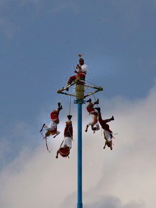
The Voladores
The Totonacs created a dance team called The Voladores (flyers or bird-men) as a plea for rain during an extended drought. (Photo by Laura Henchman)
The Totonacs created a dance team called The Voladores (flyers or bird-men) as a plea for rain during a particular extended drought. The pole is 150 ft high with a square platform top where a flutist stands tooting while the dancers attach themselves by the ankles to ropes intertwined to the platform. Once the team commits to fall off the platform backwards the slow descent begins, unwinding the ropes while twirling through space with outstretched arms to a successful landing in front of an always appreciative audience that releases a collective sigh of relief that all is back to normal.
In March there is a festival celebrating the Spring Equinox (Cumbre Tajin) that is famous for its spiritual environment, bringing together a broad collection of artists and musicians. It’s the perfect place for finding life-balance for the New Year. Here is a Web Site that tells more about the festival: https://www.cumbretajin.com/
I hope you enjoyed my tour of our little corner of the world as much as I enjoyed writing it. Perhaps I can add to the story as I discover more secrets of Veracruz.