Where the Fog Refused to Roll: A Desert Rat’s Tale at Point Reyes Pictures of the Month - Point Reyes, California

White historical building with cupola at Pierce Point Ranch, Point Reyes, California
A Glimpse into History: The Schoolhouse at Point Reyes – A historical building at Pierce Point Ranch, Point Reyes, featuring a cupola that suggests it may have served as a schoolhouse in its heyday.

You might wonder why Queen Anne and I chose Point Reyes as our summer escape from the desert. The answer is simple: wasn’t it Mark Twain who famously quipped, “The coldest winter I ever spent was a summer in San Francisco?” Couple that with data I found from the Point Reyes lighthouse, which proudly claims to be the “foggiest and windiest place on the California coast,” and you’ve got a lure strong enough to reel in two desert rats like us faster than a piece of cheddar in a spring-trap.

Besides, I watched a Back Roads West YouTube video by Cliff and Ilene Bandringa last year that made Point Reyes look like a cool, misty oasis—a refreshing break from the sweltering Arizona sun. What could go wrong if we spent a week soaking in Frisco’s damp air without shelling out for those $300-a-night hotel rooms?

So, when the summer heat finally got to us, we stuffed Anne’s shoes, her mountain of books, and just enough room for my camera gear into her gutless little Corolla. Sure, it couldn’t pass a tumbleweed on the open highway, but with 35 miles to the gallon, who’s complaining? After all, we needed to save money for wine. And so, west we went, dreams of cool fog dancing in our heads.

White Dairy Buildings with Monterey Cypress at Pierce Point Ranch
A Quiet Moment: White Barns and Monterey Cypress at Pierce Point Ranch – Two white dairy buildings at Pierce Point Ranch, framed by the distinctive Monterey Cypress trees. A testament to the historical dairy farming era of Point Reyes.

Geology of Point Reyes

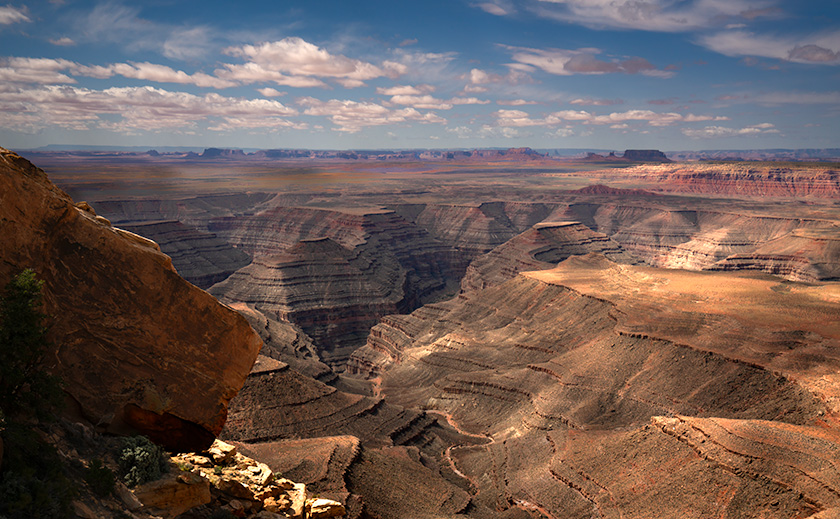
If you look at a map, Point Reyes juts out into the Pacific like an island tethered to the California coast—an island at dock. Geologically speaking, it nearly is an island, sitting on its own chunk of land on the Pacific Plate. The San Andreas Fault runs through Tomales Bay, separating Point Reyes from the mainland. It’s as if the Pacific and North American plates decided to part ways, leaving Point Reyes awkwardly perched on the edge.

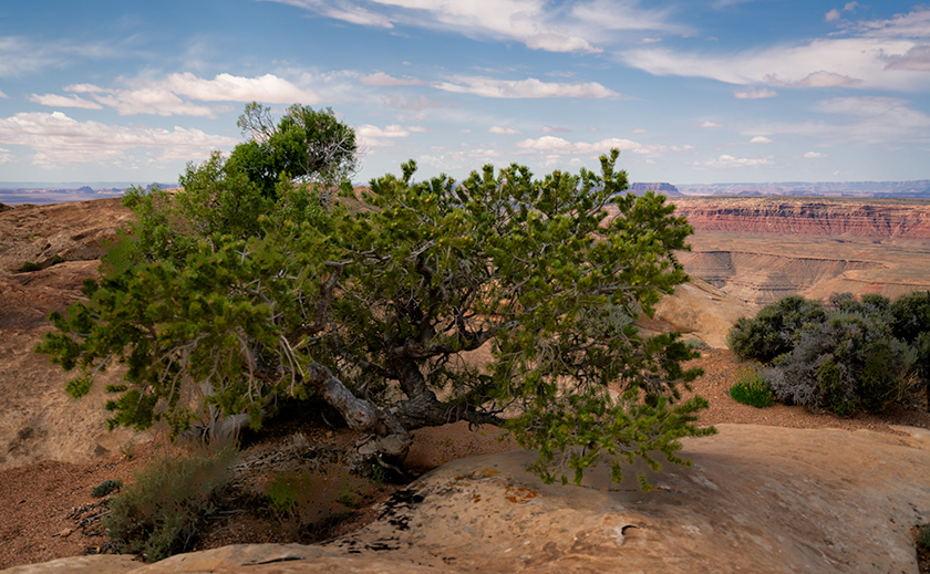
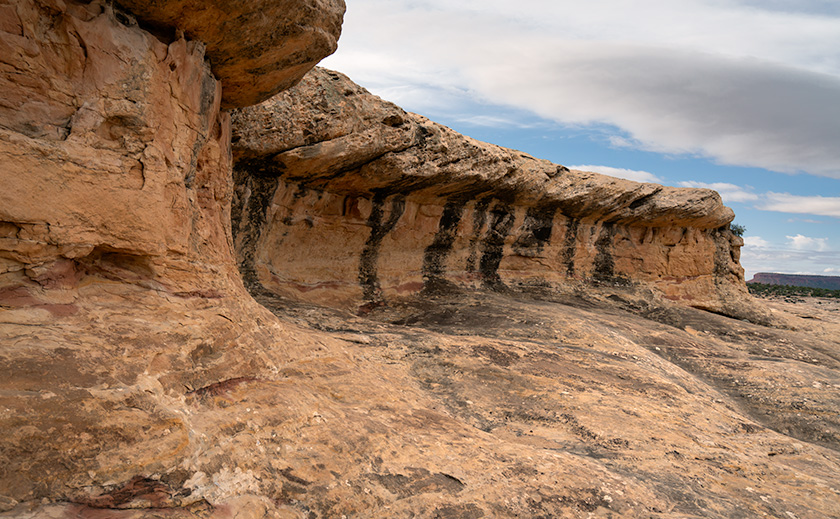
The landscape here is a study in contrasts. The peninsula’s eastern side gently slopes up from the coast, eventually rising to a broad plateau that stretches across the western half. This plateau is a patchwork of windswept grasslands dotted with clusters of Monterey Cypres trees that stand out—gnarled, twisted, and pruned by the persistent winds that whip across the plateau. They seem to lean into the wind, shaped by years of relentless gusts that have carved their forms into something resilient and hauntingly beautiful. As you journey westward, the land meets the ocean in a dramatic drop-off, with cliffs that plunge into the Pacific, as though the land falls away into the sea.

Historically, the cool coastal climate and fertile soils made this plateau an ideal spot for dairy farming. In the late 1800s, families like the Pierce and McClure clans established sprawling dairy farms here. However, as with many land use stories, controversy followed. Over time, concerns about environmental degradation grew as the cattle impacted the fragile coastal ecosystem.

Eventually, the tide turned, and the land began to be reclaimed. Today, Point Reyes is home to a thriving Tule elk population, roaming freely across what was once pasture. The elk symbolizes the land’s restoration, while the weathered barns and ranch buildings, now abandoned, stand as silent reminders of a different era. But it wasn’t just the history that called me—the photos first made me drool.

Close-up of weathered upper windows on a rustic building at Pierce Point Ranch, Point Reyes, California
Weathered Wood and Windows: A Closer Look at Point Reyes’ Ranch Buildings – A close-up of the weathered wood and upper windows on an auxiliary building at Pierce Point Ranch showcasing the rustic charm and history of Point Reyes.

Pierce Point Dairy

As soon as I saw those weathered barns and fog-cloaked pastures, I could visualize myself working in the damp, misty air, capturing the kind of light Andrew Wyeth made famous in his iconic rural scenes of Maine. Photographing these barns and windswept trees with that soft, ethereal light seemed like the perfect opportunity to channel Wyeth’s muted tones and quiet beauty—not on canvas but through the lens.

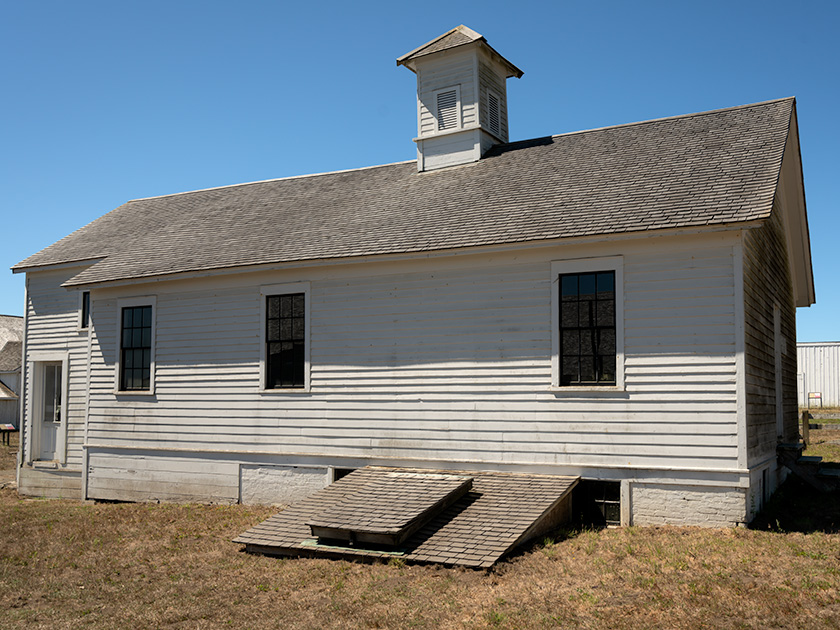
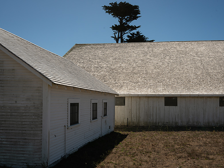
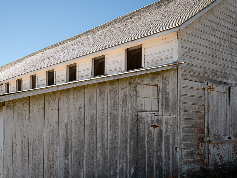
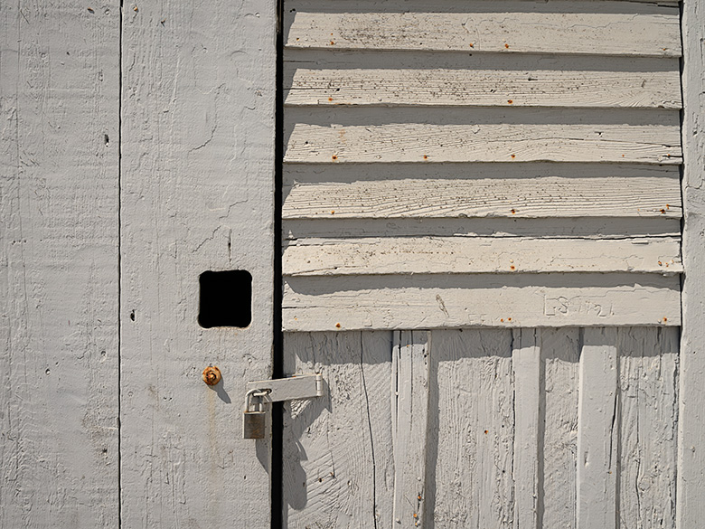
Pierce Point Ranch is one of the oldest and most significant dairy farms on Point Reyes. Its weathered white barns are a testament to California’s agricultural past. Established by the Pierce family in the 1850s, the ranch was part of the Point Reyes dairy boom, when the cool coastal climate made this land perfect for dairy farming.

At its height, the ranch produced butter and cheese for San Francisco and beyond, shaping the region’s early economy. The Pierce family and others carved out a life here, managing their cattle amid some of California’s most stunning—yet harsh—landscapes.

But as time passed, so did the viability of dairy farming. Environmental concerns over the cattle’s impact on the land eventually led to the phasing out of ranching operations. Today, Pierce Point Ranch is preserved as part of Point Reyes National Seashore, a symbol of the area’s agricultural heritage. The ranch buildings remain their whitewashed walls standing in quiet contrast to the now-peaceful surroundings, save for the occasional Tule elk wandering nearby.

However, getting to the ranch is an adventure in itself. The road leading to Pierce Point is paved with just enough potholes to make you consider airing down the tires—something I usually reserve for off-roading with the Turd. It felt like I was off-roading on asphalt! As I carefully navigated each crater, I couldn’t help but think how this rugged drive suited the history of the place, where dairy farmers once worked the land in equally challenging conditions.

Close-up of a weathered door with a padlock, showing the rustic texture of a building at Pierce Point Ranch, Point Reyes, California
Rustic Charm in the Details: The Door of a Ranch Building at Pierce Point – A close-up of a weathered door with a padlock at Pierce Point Ranch, highlighting the rustic textures and historical wear of this Point Reyes building.

The Photographs

When we arrived at Pierce Point Ranch, I felt like I’d brought the brutally clear desert air. Not a single trace of fog was in sight. Standing in the crystal-clear air, we could see the fog banks hovering about three miles offshore as if they were paranoid of catching Valley Fever, our local desert respiratory disease unique to arid climates.

I envisioned working in the soft, diffused light made famous by Andrew Wyeth, but the fog had other ideas. It stayed away as if allergic to my presence. Faced with the harsh reality of bright sunlight and whitewashed buildings, I figured if I couldn’t be Wyeth, I’d channel my inner Pete Turner instead—leaning into the bright colors and sharp edges, capturing the contrast and crispness of the scene.

The ranch sprawled around me like a Hollywood set constructed by Cecil B. DeMille as my personal photography playground. I wandered around merrily, snapping away. The clear skies may not have given me the moody atmosphere I’d hoped for, but they offered a different kind of beauty—a bold, vibrant one. I was as happy as a kid at a drugstore soda fountain with a twenty-dollar bill to spend.

Wrap-up

Now, before we wrap things up, I’ve got to share a story my mother used to tell us about growing up on a farm in Kentucky. Believe it or not, one of her favorite things was feeling chicken and cow manure squishing between her toes. Aren’t you glad I left that part out of my story?

Thanks for coming along on our journey to Pierce Point Ranch—I hope you enjoyed the show! My website has larger versions of these photos [jw link]. They will remain online for three months before they are replaced or removed. Feel free to dive in and explore the details.

I’d love to hear from you! Do you have any thoughts about the photos, the story, or maybe some farm experiences of your own? Drop a comment—we enjoy hearing your stories and feedback. Be sure to return next month for our journey home—it’s bound to be just as exciting, if not a bit cleaner.

Keep your milk fresh and your cheddar sharp.
jw

BTW: As we began our journey south on the 101 early Sunday morning, the hilltops were shrouded in low clouds, and just before we crossed the San Mateo Bridge, I had to turn the windshield wipers on. The fog was that dense. I guess I finally got my foggy California experience after all. You bastards!

Cedar Mesa Chronicles: A Photographer’s Escape Picture of the Month - Bluff, Utah

View from Muley Point of the San Juan River goosenecks with Monument Valley in the distance and cloud shadows on the ground
Captivating Views: Goosenecks and Monument Valley from Muley Point – From Muley Point, the San Juan River’s goosenecks carve a winding path, with Monument Valley faintly visible on the horizon. Cloud shadows dance across the rugged terrain.

I can count on one hand the number of times I’ve been utterly captivated by a view during my days as a photographer. I’m talking about scenes that felt like they encompassed the entire world, vistas so mesmerizing that they made it nearly impossible to walk away. Places like the Summit Road on the Banks Peninsula in New Zealand, the patio of the North Rim Lodge at the Grand Canyon, Horseshoe Bend outside of Page, Arizona, and Bryce Canyon from Powell Point in Utah. These weren’t just beautiful landscapes but revelations that deepened my understanding of geography. During my May visit to the Bears Ears area, I discovered another such place—Muley Point on Cedar Mesa.

Why I Stopped at Muley Point:

From last month’s article, I drove to Utah intending to spend several days photographing various areas on the south side of Bears Ears National Monument. However, my trip was cut short when I threw out my back. After packing up and heading home from Natural Bridges, my back felt better within the supportive confines of the Turd’s captain chair. With some relief, I decided to stop and inspect the Muley Point overlook for future trips.

The three-mile dirt road to Muley Point was easy to traverse. When I arrived, I exited the truck, wandered the area, and took in the sights. I was immediately impressed. So much so that I decided to take some photographs, which meant returning to the SUV to fetch my camera and retracing the loop I had already hiked. Despite my initial setback, I’m glad to say that in the short time I was there, I managed to capture enough images to support this post.

iñon pine tree growing on the edge of Cedar Mesa in the Utah desert
Life on the Brink: Cedar at Cedar Mesa Edge – A cedar (piñon) tree clings to life along the edge of Cedar Mesa, demonstrating the incredible resilience of nature in the harsh Utah desert.

Geological Marvel:

Cedar Mesa, a striking landscape in southeastern Utah, is a geological marvel shaped by millions of years of natural forces. The mesa is primarily composed of Cedar Mesa Sandstone, a distinct formation different from the more well-known Navajo Sandstone. While Navajo Sandstone is renowned for its sweeping, cross-bedded dunes indicative of ancient desert environments, Cedar Mesa Sandstone is characterized by its horizontal layers, formed from sediment deposits in ancient coastal environments during the Pennsylvanian period, roughly 300 million years ago. These layers of sand and silt were compressed and cemented over time, creating the durable rock formations that define the mesa today.

The San Juan River, which carves its way through Cedar Mesa, has shaped one of the most dramatic landscapes in the region—the Goosenecks. These deep, serpentine bends result from a complex interplay between the uplift of the Colorado Plateau and the river’s erosive power. As the plateau slowly rose over millions of years, the San Juan River cut into the rock, deepening its channel. The combination of vertical uplift and horizontal river erosion created the meandering goosenecks, considered the deepest on the planet. These geological features provide a breathtaking testament to the relentless and patient forces of nature that sculpt our world.

Large fractured sandstone block perched on the edge of Cedar Mesa, shaped by natural erosion processes
Perched for a Fall: Cedar Mesa Sandstone Block – A fractured block of Cedar Mesa sandstone, shaped by wind, rain, and freezing temperatures, teeters on the mesa’s edge, ready to tumble down the cliff.

Cultural Significance:

Cedar Mesa and the surrounding Four Corners area are rich with traces of ancient cultures that once thrived here. The earliest known inhabitants were the Basketmaker people, who lived in the region from around 1500 BC to 500 AD. These early agricultural societies were named for their exceptional skill in weaving baskets, which they used for storing food and other essentials. The Basketmakers lived in semi-subterranean pit houses and were among the first to cultivate maize, beans, and squash in this arid landscape. Their success in agriculture, hunting, and gathering allowed them to establish relatively stable communities.

Following the Basketmakers, the Ancestral Puebloans, often called the Anasazi, inhabited the region from approximately 500 CE until the late 1200s. This period saw the construction of elaborate cliff dwellings and multi-room stone structures, many of which still dot the landscape of Cedar Mesa and Bears Ears today. The climate during the 12th century was somewhat wetter, supporting agricultural practices and allowing these communities to flourish. However, prolonged droughts in the late 13th century, along with social and possibly environmental pressures, led to the eventual migration of these people. They moved south and east, eventually becoming the Hopi, Zuni, and other Pueblo tribes of today. These migrations were driven by the need for more reliable water sources and agricultural land, leading to the dispersion and evolution of their cultures into the tribes we recognize today.

Twisted juniper tree growing out of sandstone rocks on Cedar Mesa, displaying an ancient and resilient nature
Twisted Roots: Cedar Mesa’s Resilient Juniper – A twisted juniper tree grows out of the sandstone rocks on Cedar Mesa. Despite its short height, the tree’s ancient trunk reveals its significant age and resilience.

Final Thoughts:

If you’re a desert lover like me, prepare to fall head over heels for Cedar Mesa. This place is a treasure trove of breathtaking vistas and rich subject matter, perfect for photographers and artists alike. It’s hard not to be captivated by the sheer beauty and history of the landscape. I plan to return here often. With the wonders of Bears Ears and the Grand Staircase nearby, it’s challenging to justify going anywhere else—except for the occasional indulgence in wine and coastal views to shake things up. If you visit, please be mindful to preserve this natural wonder for future generations.

Thank you for visiting and joining me on this journey. Head to my website or Fine Art America for larger versions of these images. These new photos will be featured for three months before they’re refreshed with new adventures. Since it’s August and we’re escaping the sweltering heat, stay tuned for next month’s article, where we’ll share our adventures on the Pacific coast. Until then, I’d love to hear your favorite views or stories from the Four Corners in the comments.

Until then, keep your humor dry and your eyes on the road.
jw

Natural Bridges: Beauty, Bears, and Backaches Picture of the Month - Natural Bridges National Monument

Eroded rock overhang with dark varnish stains in Natural Bridges National Monument
Ancient Waterway Overhang with Varnish Stains—Sedimentary layers and mineral stains highlight the geological history of this Natural Bridges formation.

I may not be the rugged outdoorsman that I appear to be. Until two years ago, Queen Anne’s and my camping world revolved around our little Casita trailer. We took it everywhere, from the Grand Canyon to Alaska. However, we had to part with it due to unforeseen circumstances and began using motels for our overnight trips.

As much as we enjoy watching The Big Bang Theory reruns in our motel room at night, it’s not the same as sitting around a campfire under the stars and eating Jimmyums. Recently, I decided that I would get back to basics on my next photo shoot—and the perfect opportunity was coming up.

Queen Anne’s Adventure

Anne’s sister Jane called about one of her bucket list items: a road trip to Utah’s Mighty-Five National Parks. Anne jumped at the chance to travel with her sister and even offered to drive. Their tour started for two weeks but got whittled down to a week by the time they left. While they were off ‘Thelma and Louise’-ing their way across the Beehive State, I decided to use that time to explore the Bears Ears National Monument near Blanding. After all, when we bought the Turd—my RAV4—I made sure there was room for me to stretch out in the back.

View of Owachomo Bridge from the canyon rim in Natural Bridges National Monument
Natural Beauty: Owachomo Bridge from Above- The delicate span of Owachomo Bridge is set against the rugged canyon landscape.

Preparation for the Trip

As I prepared for my adventure, I dug out the remains of our camping gear from the attic and added some kitchen items to augment them. Since I’d be alone, I bought a bunch of canned goods for food, reducing the need for an ice chest. I always heated them on my single-burner propane stove when I camped as a younger man. Besides, Cup-O-Noodles and coffee make for an easy, warm meal on those chilly mornings.

One thing I splurged on was a heavy-duty air mattress. I can no longer tolerate sleeping on a hard surface without a cushion. The one I bought from Amazon was designed to fit in the back of SUVs. It’s T-shaped and broad at the back doors, then narrows between the wheel wells. Another nice feature is that each side inflates independently—so I could pack my camp boxes on the deflated side while day traveling. Did I mention that it was guaranteed not to leak? Yeah, about that…

Once the girls got a head start, I carefully packed my new mattress, all of my photo gear, plenty of clean socks and undies, and the rest of my provisions into the Turd and set off on my 9-hour journey to Natural Bridges National Monument in Utah. On the road again—what could go wrong?

The Struggle

I arrived at the park after 4:00 p.m., so the campground was full. I expected that, but the BLM runs the Mani-La Sal forest, so throw-down camping is permitted, and I had ample time to find a good spot. Before long, I backed into a lovely level spot surrounded by Ponderosa pines beneath the towering red cliffs of Bears Ears.

The air had a damp-cool chill, so I put on the sweater I brought before setting up camp. Since I didn’t have a table, I used my sturdy camp box for one, which doubled as an ottoman after dinner. I stowed the rest of my boxes on the truck roof to keep them out of the dirt.

After emptying the back of the Turd, I unrolled my mattress and started inflating it using the portable pump that it came with. Before I began to inflate the passenger side, I looked closely at the sky and felt it would rain, so I moved the rest of my boxes back inside along the flaccid side of the bed. It cramped my bed space, but I’d be fine since I wasn’t planning on spooning with a bear.

Before dinner, I had time to wander and capture video clips of the red cliffs and trees in the sunset. Upon returning to camp, I prepared an Epicurean meal of warmed-over canned ravioli, a cup of peaches, and a cup of tapioca pudding. As the night grew late, I gathered my things and climbed into the back of the truck. Ah! The life of Reilly.

Outside was silence except for the trees rustling in the gentle breeze—a cowboy’s lullaby. The yellow moonlight was coming in the passenger side windows as I dozed off. I watched it a bit before snuggling into my sleeping bag as sleep crept over me.

The next thing I knew was feeling uncomfortable and opening my eyes to figure out the irritation. The moonlight was now at the back door, so hours must have passed. The mattress still had air, and the sleeping bag was warm. What’s nagging me? Then it hit me: as an old man with a prostate the size of a grapefruit, I had to pee. The one thing that I hadn’t taken into consideration. I needed to get up and out of the truck—NOW.

First, I untangled myself from the twisted sleeping bag and opened the zipper. I began feeling around for my boots, and as I tried to put them on, the laces were tight, so I had to fix that. Once I had them on my feet, I opened the door on my right. While grabbing the handle over it, I tried lifting my legs and pivoting them out the opening, but my right leg got caught in the useless seat belt harness. After freeing myself from the straps, I successfully extracted myself. As I slowly unrolled into a standing position, my back said, “Don’t ever do that again.” But it was not to be. Simone Biles would have been proud to pull off that gymnastics routine once, but I did it three more times that night—and my back seized up in protest.

View of Kachina Bridge from the canyon rim in Natural Bridges National Monument
Natural Splendor: Kachina Bridge from the Rim-Kachina Bridge’s grand arch spans the lush canyon below, offering a stunning contrast of colors.

Where’s My Towel?

I could barely walk when I got out of the truck the final time. Dawn lit the eastern sky, so I hobbled over to my chair and managed to put on a pot of water. As I sat and drank my instant coffee, I pondered my predicament. I had driven a long way and hadn’t snapped a single photo, but I certainly couldn’t spend another night injuring myself in the truck. Not until I can figure out a better method of extracting myself.

I threw in the towel. After my coffee, I started packing the truck, including the camp box that was now too heavy for me to move. I had to remove its contents, then drag the big empty box into the Turd, and finally repack it.

Play Through the Pain

After I had loaded the RAV4, I drove back to the park’s visitor center. It was closed, and I had the entire park to myself. I convinced myself that I could do some shooting even if it meant not hiking down into the canyons. So, as daylight broke, I raced another car from Texas from overlook to overlook, taking pictures. Where the hikes were level and short, I walked like Quasimodo, pulling myself on the handrails where I could.

Storm clouds gathering over Cedar Mesa Sandstone in Natural Bridges National Monument
Thunderstorm Approaching Cedar Mesa Sandstone in Utah – The interplay of storm clouds and Cedar Mesa Sandstone highlights the raw beauty of Natural Bridges.

Notes To Future Self

After I returned home and reviewed my images on the computer, I was happy to find they were publishable—I must have been on auto-pilot. They weren’t the ones I hoped to get, but that encouraged me to return soon. Even hiking in pain may have been beneficial. My back feels much better after a week of rest and light work. The constant low-level pain is there, but that’s how people my age know which of their body parts are still attached. I also conjured some strategery for the next trip—like providing a handy stash for my car keys, opening the tailgate with my remote, and then rolling over on my hands and knees and backing out that door. I’m also going to keep a pair of loafers in the Turd.

Thank you for joining us again this month. I hope you enjoyed my Utah horror story more than I did. As we customarily do, larger versions of my photos are available for you to examine on my website <Jim’s New Work> and on the pages that I created on Fine Art America <FAA Page>. They will be on display for three months before being rotated. Finally, Queen Anne and I can hardly wait to hear the ribbing you’ll give in the comment section. Please share your thoughts about the photos, camping, Utah, or travel horror stories. We love to hear from you.

Until then, keep your spirits high and your Ben Gay handy.
jw.

Suspended in Time: Adventures Beyond the Petrified Forest Picture of the Month - Petrified Forest National Park

Colorful petrified wood logs under a dramatic sky at Petrified Forest's Rainbow Room with the White Mountains on the horizon
Clouds Over Color: A Journey Through Time: The Petrified Forest’s Rainbow Room captivates with its rich hues of fossilized logs, set against a backdrop of the White Mountains and a dramatic sky.

We were parked on Blue Mesa in Petrified Forest National Park under a new moon when something strange happened. One moment, it was a quiet desert night—just me, Queen Anne snoozing in the truck, and a few restless coyotes yipping in the distance. The next second, everything went dead silent.

Then, as if the universe was playing a cosmic joke, the planets aligned in perfect alphabetical order across the sky. I didn’t even know that was possible. Maybe Jupiter bribed Mars to cut in line. Either way, it felt like the kind of thing that shouldn’t happen unless reality had a glitch.

And then, out of nowhere, a weird blue light appeared. It wasn’t headlights or a flashlight beam—this thing swirled like a dust devil but didn’t kick up dust. Instead, it glowed like the inside of a plasma ball at a science museum. Anne told me to stay in the truck. Naturally, I didn’t listen.

I edged closer. The light wasn’t just floating—it was a hole—a hole in the universe, a hole that swallowed the stars behind it. The sheer impossibility of its physics beckoned me closer yet filled me with an instinctual dread.

Retreating momentarily, I fetched a new tee shirt from our recent gift shop visit, wadded it into a makeshift projectile, and lobbed it at the spectral phenomenon. On contact, the light flared like a campfire doused in brandy, the tee shirt evaporating into a blaze of unknown physics. In its place, a window appeared—one that looked out onto another world.

Except it wasn’t another world. It was this world—just a couple hundred million years earlier.

Two vibrant red petrified logs in the middle of Petrified Forest National Park against a desert backdrop
Timeless Twins: Petrified Logs Standing Sentinel in Arizona’s Heartland—Red Remnants of Prehistory: Twin logs of petrified wood stand in stark contrast to the barren terrain of Petrified Forest’s central expanse.

The contrast was striking. Below me, the landscape stretched out at a significantly lower elevation, nowhere near the mile-high expanse of the modern Colorado Plateau. The sun blazed directly overhead, a stark reminder that this land had once been closer to the equator. What had been a blue-gray dust bowl moments ago was now lush and green—forests of towering Norfolk Island Pines lined the banks of a river fed by distant volcanoes.

A sense of awe welled inside me. I was witnessing the Triassic Period—the dawn of the dinosaurs. This was the initial deposition of what would one day become the Chinle Formation. I recalled from my readings that this geological stratum could reach staggering thicknesses of up to 1,000 feet, layering mud, volcanic ash, and silt into a colorful geological record. Each layer was a story in minerals left behind by cataclysmic floods—floods that had entombed trees, animals, and entire ecosystems in time.

I turned to tell Anne, but she was out cold—head propped against the window, breathing fogging up the glass with every snore. Occasionally, one got loud enough to jolt her awake, only for her to blink in confusion and drift right back off. The coyotes had gone silent, probably unnerved by the glowing vortex, but Anne’s snores carried on, oblivious to time travel unfolding just outside her window.

As I turned back to the portal, movement along the tree line caught my attention. A herd of dinosaurs grazed contentedly on the lush ferns, their stocky bodies covered in what looked like prehistoric leather armor. They had the build of a hippo, the tusks of a walrus, and the personality of a slightly confused cow. Upon later research (a.k.a. Wikipedia), I learned these were Placerias, some of the last big herbivores before the actual dinosaurs took over.

I watched in fascination—until I noticed two of them playing with an orange Frisbee. No, seriously. One scooped it up with his tusks and flung it across the meadow. The other caught it, twirled it, and then sent it flying back with an expert head flick—a prehistoric game of fetch.

That’s when I saw it. One of them was wearing my tee shirt.

Several large pieces of petrified wood clustered together in Petrified Forest's agate section
Agate Assembly: Petrified Logs in Nature’s Mosaic at Petrified Forest – Scattered Legacy: A cluster of petrified logs in the agate-rich grounds of Petrified Forest, each piece a fragment of prehistoric life frozen in time.

Reality teetered. Somehow, the vortex wasn’t just a window—it was a two-way door. My gift shop souvenir had traveled through time, and now, a pair of Placerias named (in my mind) Gonzo and Norm were engaged in a high-stakes game of Triassic Ultimate Frisbee.

Their game was a peculiar sight—half-fetch, half-soccer, with all the earnestness of Olympic competitors. It was a scene of sporting prowess that would have baffled even the most imaginative sports commentator. Amid my amusement and disbelief, a part of me couldn’t help but feel a touch envious of their uninhibited joy—a stark contrast to my usual self-deprecation and haplessness, which at that moment seemed confined to the sidelines of time.

It was a bizarre sight—part football scrimmage, part comedy routine. Norm, the bulkier of the two, lined up his shots while Gonzo made wild, dramatic leaps for the disc. The game might have gone on forever without a sudden, ominous shift in the air.

Dark clouds swelled over the distant volcanoes. A deep rumble rolled through the valley. The river that had seemed so tranquil moments ago was now choked with debris, swelling at an alarming rate. It wasn’t just a storm—it was a flood—a Triassic monsoon.

The realization hit me—this is how the fossils formed. This was the very moment when entire forests were buried, trees transformed into stone, and creatures like Gonzo and Norm were swallowed by history.

The Frisbee dropped. Gonzo and Norm turned, finally sensing the danger. They ran. Well, they tried to. Norm’s stubby legs churned in slow motion while Gonzo, the optimist, still attempted one last throw. The roar of the flood drowned out their squeals. Within seconds, a massive wave of mud and debris swallowed them whole.

The portal flickered. The colors blurred. And then, it was gone.

The coyotes started howling again. Anne stirred. “You ready to return to the motel?” she mumbled sleepily.

I nodded, glancing at the now-empty desert. The past was the past again.

Before leaving Holbrook the following day, we stopped at the park’s gift shop. I searched for a replacement T-shirt but found nothing. Then, as if on cue, the cashier said, “Funny thing—rangers found one like that near a dig site. It’s in lost and found. Want to see it?”

She handed me a stretched, dirt-crusted shirt—with a punctured orange Frisbee sitting underneath it.

I stared. I laughed. And I took it. Because sometimes, the universe has a way of letting you keep the souvenirs that really matter.

Deep erosional textures of the Chinle Formation seen from Blue Mesa walkway in Petrified Forest National Park
Blue Mesa’s Eroded Wonders: Textures of Time in Petrified Forest—Nature’s Sculpture: Blue Mesa’s eroded beauty unveils the Chinle Formation’s intricate textures, a testament to the relentless artistry of natural forces.

Thank you for joining me on this incredible Petrified Forest National Park journey. Suppose you’ve enjoyed this tale of prehistoric whimsy and modern-day mystery. In that case, I invite you to explore larger versions of this month’s images on my New Work Portfolio. These photos will be displayed there for three months before being rotated.

As the echoes of the ancient past slowly fade, let’s turn our gaze to a different historical exploration. Next month, join me for a night among the neon and nostalgia of Gallup’s abandoned motels. We’ll explore the haunting beauty of old motel signs, capturing the stories they whisper to the desert winds. Don’t miss this eerie yet visually captivating journey—subscribe now to get a reminder as soon as we go live.

Until then, keep exploring the layers of history around you, and perhaps you’ll discover your own story woven into the fabric of time.
jw

Holbrook Chronicles: A Quirky Journey Through Time and Asphalt Picture of the Month - Holbrook, Arizona

White tee pee-shaped motel rooms with classic car parked outside on Route 66 in Holbrook, Arizona
Nostalgic Nights: The Historic Tee Pee Motel of Route 66 – Step back in time with a glimpse of the historic TeePee Motel on Route 66 in Holbrook, Arizona—where classic cars and unique accommodations summon the spirit of America’s golden age of road travel.

Earlier this year, in a fit of cartographic embarrassment, I noticed my Arizona map was as barren in the northeast corner as my understanding of quantum physics. We use the map to bookmark locations we’ve visited and shared with you. “We must address this travesty,” I declared, or perhaps just thought loudly. Thus, Queen Anne and I embarked on an expedition to Holbrook, a place as famed for its petrified wood as my living room is for lost remote controls.

Upon our grand arrival in Holbrook, it became immediately clear how the town’s history was as layered as my attempt at a seven-layer dip, which never made it past layer three. From the ancient trading routes that seemed slightly busier than my last garage sale to the modern buzz of I-40, which promised the thrill of gas stations and fast food, Holbrook whispered tales of change. And by whispered, I mean it mumbled incoherently, much like Uncle Ray after his third Thanksgiving cocktail.

Wide-angle photo of playful dinosaur sculptures in a rock shop yard in Holbrook, Arizona, with petrified wood for sale
Petrified Pals: The Dinosaur Ambassadors of Holbrook’s Rock Shop – Encounter the past in a playful panorama with Holbrook’s roadside dinosaurs, a nod to the rich paleontological history unearthed at the nearby Petrified Forest National Park.

Diving into the town’s lore, we uncovered tales of early Pueblo peoples, whose idea of commuting was traipsing along the Little Colorado River. They traded goods with the enthusiasm I reserved for exchanging unwanted Christmas gifts. Picture them, settling down by the river’s edge, not to snap sunset selfies, but to swap stories of Coyote, the original trickster who probably invented the concept of “fake news,” and Spider-Woman, the ancient weaver who, unlike me, never blamed her tools for a botched job.

Then came the white men, striding into the horizon with all the subtlety of a brass band in a library. With their grand plans to connect coasts, Lieutenant Whipple and Edward Beale undoubtedly paused to ponder, “Will there be sufficient parking?” Their surveying tales were likely less about the awe of uncharted lands and more about the days when their socks stayed dry.

Early Settlement

In 1876, Mormons fleeing the excitement of Utah found solace in what would become Holbrook, a place that made their former home seem positively Las Vegas-esque in comparison. By then, the town had started to take shape, much like my attempt at sourdough during lockdown—full of hope but ultimately flat.

Our foray into this historical mosaic first led us to the part of town that had seen better days. “I’m not getting out of the car,” declared Queen Anne, with the determination of someone guarding the last slice of pizza. And who could blame her? The charm of the Arizona Rancho and the Bucket of Blood Saloon was as evident as the potential in my high school yearbook photo—present, but requiring a generous imagination.

Pedro Montaño built the Arizona Rancho home here between 1881 and 1883. It started as a single-story plastered adobe building with a high-pitched roof and dormer windows. After it was sold to the Higgins family, it became the Higgins House—a boarding house with a two-story addition. Next, it became the Brunswick Hotel. In the 30s, the west wing was used for Holbrook’s hospital, and during World War II, the Navy leased it to house pilots training at the airfield north of town. Now, it’s listed on the National Historic Registry and appears to be undergoing renovation.

Crossing the street from the train depot is another historic building in decay. It was initially called Terrell’s Cottage Saloon, and it was popular with cowboys and ruffians. After a violent gunfight in 1866 that ended up with two men dead, the street was described as if someone had poured a bucket of blood on it. The name stuck, and the saloon and street name bear the moniker. When we visited, a prominent sign urged people to contribute to saving The Bucket of Blood Saloon.

Imagine Holbrook as the Wild West’s version of a reality TV show, complete with outlaw gangs and cattle thieves vying for the title of Most Wanted, starring the Hashknife Gang and the Blevins Brothers, with special guest appearances by the Clantons, who thought the Earps’ version of justice was a tad too personal. Enter Sheriff Commodore Perry Owens, Holbrook’s answer to a sheriff who didn’t just wear a badge but practically invented the law enforcement genre with flair. His Wikipedia page? It’s the binge-worthy history lesson you never knew you needed.

Traffic Increases On Route 66

Faded green signage on an abandoned gas station under dramatic sky in Holbrook, Arizona
Deserted Drive-Up: The Withered Gas Station under Holbrook’s Sky – Behind a chain-link time capsule, the remains of what could be a Sinclair station stand sentinel under the vast skies of Holbrook, a mute testimony to the bustling days of Route 66.

Holbrook thrived on a cattle economy akin to a bovine social club for decades until 1926 rolled around with Route 66, flipping the script. Suddenly, Americans, intoxicated by the freedom of their Model Ts, were gallivanting across the country, pioneering the original road trip minus the luxury of air conditioning or reliable GPS. The Dust Bowl era added a gritty reality show twist, turning Route 66 into the “Mother Road” of all escape routes. By 1938, the road’s complete paving made cross-country jaunts less of a teeth-rattling affair, shifting Holbrook’s social scene north of the tracks. The town’s once-thriving pit stops turned into a ghostly strip of nostalgia, save for the Tee Pee Motel, now a restored relic where vintage cars outnumber guests—missing the chance to sleep in a concrete teepee? Now, that’s a modern regret.

Post Interstate 40

As Holbrook entered the fast lane of the Interstate 40 era, it seems the town, like a bewildered tortoise at a Formula 1 race, was sidelined by the rush towards efficiency. Where once adventurers might pause to marvel at the local color, they now zoom towards the neon glow of franchise signs, seduced by the siren call of combo meals and loyalty points. It’s as if America’s highways have become conveyor belts, whisking travelers from Point A to B with little regard for the stories and spectacles they blur past.

Amidst this homogenized landscape, Holbrook is a defiant reminder that sometimes the best part of the journey is the quirky diner you didn’t expect to love, not the time shaved off your ETA. In rediscovering Holbrook, we find not just a town but a treasure trove of tales begging us to slow down, look around, and maybe, just maybe, find a piece of ourselves among the echoes of Main Street. So, let’s take that exit ramp less traveled; who knows what stories await among the faded signs and whispers of yesteryear?

Old Holbrook train station sign with Santa Fe logo on a building repurposed as a warehouse along the railroad tracks
Tracks to the Past: Warehouse Days at Holbrook’s Old Depot—Standing with silent stories, the repurposed Holbrook train station along the SP tracks endures as a storied warehouse among the town’s architectural relics.

I hope you enjoyed our Holbrook tale and viewing the new photos. If Queen Anne and I have piqued your interest, you can see larger versions of this month’s adventure in my New Work collection <Link> and Fine Art America page <FAA Link>. They’ll be there for the next three months before they make way for a new adventure. Be sure to return next month when we stop at the Painted Desert and Petrified Forest.

Until our next detour, may your travels be full of discovery and stories as rich as Holbrook’s past.
jw