There’s something wonderfully romantic about how cowboys spent evenings eating beans around a fire before laying out their bedrolls and sleeping under the stars. It makes me wonder if I would have been any good riding a fence line. I love the outdoors, campfires, looking at the stars, and dreaming of the ladies back in town (sigh). I can assure you that I could never do that because the last horse I got on said, “oof” and sleeping on the ground has rocks, snakes, spiders, scorpions, skunks, and rabid chipmunks—not to mention the inclement weather.
Queen Anne and I still enjoy getting out in the wilderness; we just bring half of the house with us. For some reason, I sleep very well in our little Casita trailer. She has two layers of foam over the cushions that make into a full-size bed, and when I crawl under our down coverlet, my eyes slam shut faster than a mouse trap. As I lie next to my love and wrestle for more space, I listen to her rhythmic breathing. The hypnotic cadence is a mantra luring me to dreamland—until she misses a gear and sounds like a manual transmission exploding. But, she stops as soon as I nudge her to roll over.
All of this is fresh in my mind because we’re recently back from spending the week in the KofA Wildlife Refuge with The Ritz—our trailer. We succeeded in getting more images to finish up with this month’s topic but concluded that there is a lot more to the KofA range than a couple of blog posts. I think it may need to be a long-term project.
This tip was the first time we used the trailer in winter, and although the days were sunny, the wind blew, and the nights were colder than our Alaska trip. We had to use its heater at night. Even though we set the thermostat to 58º, it still came on often and blared at 85dB. The first time it came on, it made that burning dust smell and I thought we were going to die of carbon monoxide poising, so I opened the windows, which was counterproductive. Like all furnaces, the smell cleared eventually and we stopped jumping every time it started. Even with that racket, I slept until sun up.
We spent two days exploring and shooting photos at the refuge, and on the last day, the wind died, so we were able to use a week’s worth of wood for a fire. We ate brats, drank rich cocoa, and roasted marshmallows for jimmyums over the burning logs. Its warmth kept us outside long enough that the stars came out—all of them. We stared at Mars so hard that it began darting across the sky until we looked through binoculars and proved it wasn’t doing that. Finally, the creamy streak of the Milky Way began to reveal itself and forced me to set up my camera.
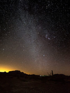
KofA Milky Way – Campers enjoy the KofA mountain range-in silhouette against the Phoenix lights-under the Milky Way and Orion early in the January evening.
This week’s featured image is the result of that effort. It’s called KofA Milky Way, and I shot it from our campsite. The bright spots on the ground are from the next camp. The mountain is Signal Peak silhouetted against the lights of Phoenix—150 miles to the east. The constellation Orion is center-right, and Pegasus with the Andromeda galaxy would be overhead, but the fire died, and the cold chased us inside before we could find it.
As usual, you can see a larger version of KofA Milky Way on its Web Page by clicking here. I hope you enjoy viewing this week’s post and next week; we’ll show another featured image from Arizona.
Oh, the joy of sleeping under the covers with the windows open. We’re in Eagar, Arizona – about four miles west of the New Mexico border. Outside, the temperature is a crisp fifty-two degrees. In Phoenix we won’t see these temperatures until Halloween. Queen Anne is still contentedly snoring in bed, so all’s quiet in the world. I see a cloudless sky through the window and the sun is about to clear the next door trailer which will make it all but impossible to type, so I’ll be quick about my report.
Yesterday’s trip was a pleasant and uneventful six hours. Two of those hours we spent traversing the Phoenix Metropolitan area to Fountain Hills where we stopped to top off the tank and buy some road food. We phone-waved Jeff as we passed his Scottsdale house. Not expecting our call, he offered to put shoes on and meet us for a bite, but we declined because we were already moving.
Fountain Hills is the point where I feel we’ve finally left town. From there we drove the Bee-Line Highway, climbing out of the Valley of the Sun to Payson’s 6000 foot elevation. We noted each time Fritz’s outside temperature indicator dropped from the low 90’s to the high 80’s. That doesn’t seem like a lot until you factor the hour and a half driving time. In Payson, we headed east on Arizona Route 260 and made the last ascent up the Mogollon Rim, and breaking through the 7000 foot elevation. From there, the rest of the way was a gentle descent. Our next way-point was Showlow and back on US Highway 60, ironically the same highway we took out of Wickenburg.
It was almost 3:00 pm when we reached Round Valley — a five-mile circular flat at the foot of the White Mountains — containing the yin yang towns of Springerville and Eagar. Springerville is on the north along US 60 while Eagar is on the south along AZ 260 with Main Street connecting the two highways (Yes, I know they’re the same roads, but there’s a method to my route madness that I’ll ‘splain someday). We stopped at the local Safeway for provisions and a bite to tide us over until dinner before checking into our campgrounds.
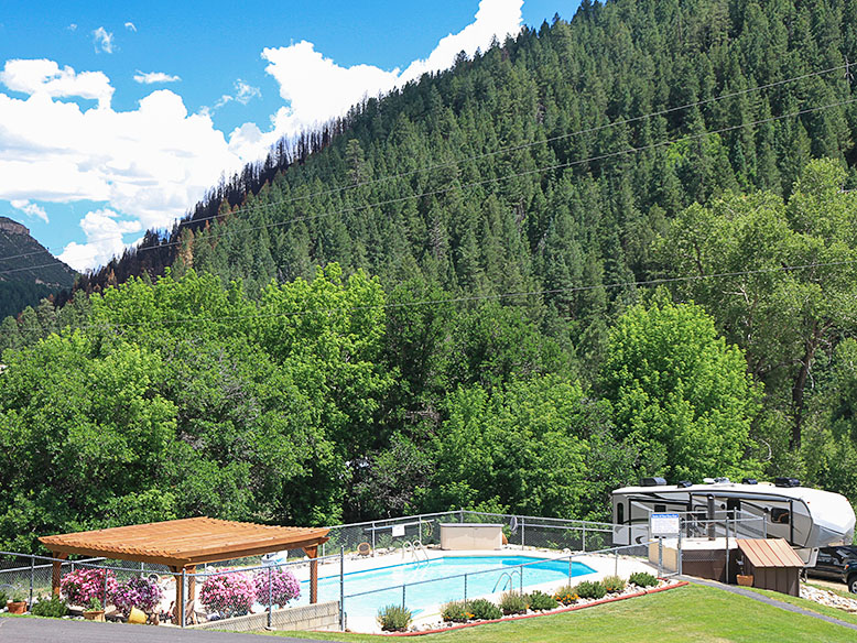
About our campgrounds … all I can say is that I’m glad that I went to Alaska last year. This place is somewhere between Watson Lake and Peace Park Gardens in Vancouver, but that’s a very large spectrum and I consider this in the bottom percentile. It’s certainly not a resort like where Fred and Deb are working. It is small and quiet with mostly permanent residences and few spaces for us transients. We picked it for the WiFi reviews and the price. The price reflects the lack of facilities (no showers). When we came in, the hosts had just finished helping a guest with a grand fifth-wheel (“The largest we’ve ever had,” he told me), before helping us with The Ritz (“The smallest one we’ve ever had”). Thanks … I guess. Anyway, behind The Ritz, we have a lovely private space under large Ash trees for sunset cocktails; how could things be better?
This morning. we’re going to spend time to lay out an itinerary for the week. We have a lot on our list and we need to rank it. One item on the list is the 2017 Great Mexican Food Springerville Shootout. Springerville has two restaurants that we like and we’re going to offer up our two cents on (last night’s dinner was at one of them — more later). We also need to spend the morning knocking off the rust on our camping skills, a fact that became obvious to us during set-up yesterday. The adventure awaits and I’ll have lots of photos for you.
It’s almost the middle of August. Queen Anne and I got our monthly allowance and paid the bills, but we have a couple of bucks left over and they’re burning a hole in our pockets, so we’re getting out-of-town for a week. The plan is to head for the hills … literally. To be precise, we’re off to Springerville and the White Mountains. Once again we’ll be camping in the trailer, or as my friend, Jeff once said, “We’ll be taking the Mercedes and spending a week in the Ritz.” That joke won’t be funny anymore if we ever get a different truck.
Normally we escape the desert’s heat at the north rim. We love going there because there’s nothing to do. So we pack all of our crap and do nothing for a week … except for sleep in the cool air, eat, snooze, drink, slumber … and then take a nap. That was before we were doing this blog, and there’s no Wi-Fi up there. There’s also no radio, phone coverage, television or any other form of communication … well, maybe smoke signals, but I’m lost without auto-correct.
We picked Springerville — actually, the town of Eager which is next door — because it’s central to a lot of touristy stuff. We found a campground that (in reviews) has decent Wi-Fi, so we’re going to go play Tommy and Tammy Tourist and write about it … just like last summer. Won’t that be fun? I hope you’ll join us.
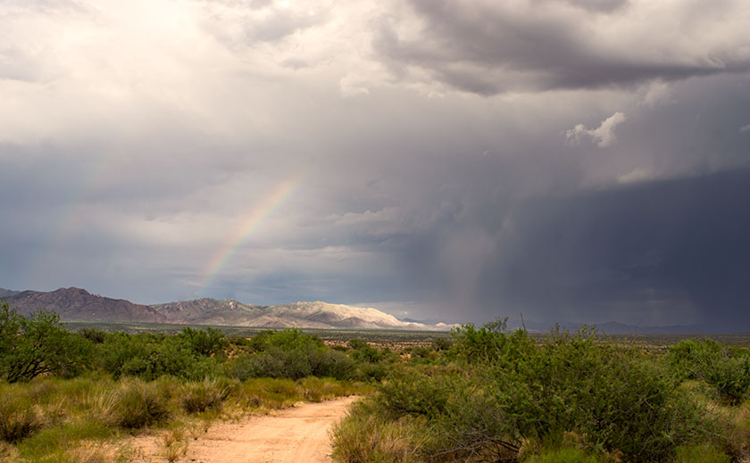
As an afternoon storm moves north, a rainbow touches a peak in the Weaver Range known as Rich Hill. Hmm.
PS: This is a new picture that I put up on my site a few moments ago. I hope you’re not tired of these storm photos because I’m having fun with them. It’s just a phase I’m going through, I’ll get over it.
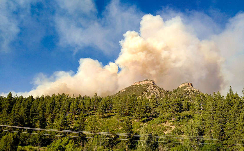
It was the Wednesday before July 4th and the Lightner Creek Campground and Cabins staff were making preparations for the busy weekend when our friends and fellow camp hosts – Tony and Amelia – raced into the park. This was unusual because the speed limit is 5 mph and camp hosts try to enforce it. They had just come back from town and breathlessly told us that there was a house on fire just east of the campgrounds. We all rushed up the park’s hill to gawk.
It was the house of our, shall we say, interesting neighbor. She lives there with her kids and they regularly shoot off fireworks and guns. On Memorial Day there were loud gun shots coming from there well into the night which made the campground guests nervous. Someone called the sheriff, but the shots stopped before they got there. One of her other neighbors said there were three loud explosions before the house caught fire. The house was burning very quickly and the color of the flames suggested that a gas fueled the flames. Rumors in the community said that she grew pot and processed something more potent in a back room, but we never verified any of that.
As we stood on the hill, we watched the fully engulfed house, when suddenly the fire jumped to the trees and started up the mountain. We all started panicking and using a lot of four letter words. Thank God the wind was blowing away from us.
Amelia – a 911 dispatcher in a previous life – asked if there was an evacuation plan. Robert and Andrea, the owners, fetched ours from office and contacted its creator – the original owner who lives alone at the campground’s west end. She came over, very upset and helped coördinate the evacuation. The plan broke the campgrounds into sections. The owners assigned camp hosts different sections and sent them to their assigned area with instructions for how each campsite should exit. We told everyone to “prepare to evacuate”. It couldn’t have been more than 15 minutes when we got a “MANDATORY EVACUATION” from Code Red – a must have cell phone app. No matter where you are in the USA, it will send you emergency alerts for your area. When the alert sounded, the camp hosts spread out to their assigned areas and began evacuating the campers. Several people were in Durango then, but we made sure anyone in the campgroundsknew they had to leave. After we got the guests out, Deb and I started to hook up our trailer, but before we could, a sheriff showed up in front of our rig and said we had to leave; NOW! So we started throwing stuff in the truck and car and abandoned the trailer. I had time to put in the awnings and turn off the propane, but that was it. A personal evacuation plan for our RV is on my to-do list from now on.
The fire quickly spread after jumping the road. Fortunately, the wind kept it away from the campgrounds.
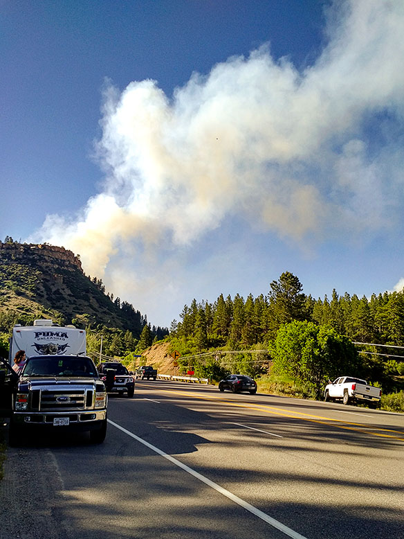
The campground is in a box canyon and the only way out was down the road toward the fire. The wind was blowing the fire away from us, but it had jumped the road and started up Perins Peak to the north. The fire had jumped across high enough that the road was not blocked. We drove through a maze of fire trucks but finally made it to Hwy 160. We assembled on the side of the highway and wondered what to do. We could see the smoke billowing out of the canyon and flames crawling up Perins Peak. We didn’t know if we would have anything to return to, but we got everyone out safely.
After getting out of the canyon, we gathered at the sided of the road to ponder what to do next.
One of the guests in the group got word that the Red Cross was at the La Plata County Fairgrounds setting up an evacuation center. A seasoned camp host knew where it was, so most of us followed him. Wouldn’t you know it, the fairgrounds booked a rodeo for the holiday and the parking lot was full. Trailers and motorhomes were redirected to the high school parking lot next door. The next day the shelter moved to the Escalante Middle School which had a big parking lot for rigs. The Rocky Mountain Team Black Hotshot fire fighters moved into the fairground shelter. By the way, the Red Cross was great! They provided a place to sleep, water, snacks, and food – donated by various town restaurants.
Deb and I opted for a hotel room instead of trying to sleep in a dormitory full of kids, dogs, and people. When I got on the phone I found out that most of the hotels were booked for the big weekend. I finally found a room at the Holiday Inn, and we spent two nights there until they let us go retrieve our trailer. One at a time, a sheriff escorted the camp hosts in to hook up trailers then get out. The fire was only 20% contained so planes were flying over us while helicopters picked up water from trout ponds close to the road. Some idiot was flying a drone in restricted air space and delayed air operations a day (he was later found and he’s facing charges).
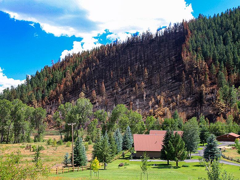
This is the ridge that the fire went up when it first started. The wind blew it over to the other side. This ridge goes right up behind the campground. The burn line runs along the ridge line and the only campground exit was down the canyon and past the fire.
It was a relief pulling our rig out of the park. We headed straight for the middle school parking lot where we dry camped for two nights. The Red Cross commandeered the dining room and they organized a big meeting on the fire’s fourth day with all the players; fire fighters, police, sheriffs, etc. who gave us the status of the fire. Denver TV stations filmed the meeting and we made the evening news. They told us that the fire was still only 20% contained, but they were letting some homeowners return to their homes. Since we were not home owners but were permanent summer residents, officials excepted the camp hosts and they issued us special Rapid Access ID cards. The next day they let us go back to the campgrounds. Whoopee! The road was still closed to the public and we couldn’t take any guests yet, but we were back in our summer home.
This is where the fire started and continued over the top of the ridge toward Hwy 160. You can see how close the fire came to the campgrounds.
Since we had the campgrounds to ourselves, we threw a 4th of July Bar-B-Que. The campground wasn’t burned at all, and the facilities were fine. The fire came closer than we thought, but it did not cross the boundary. We were very lucky. There were a lot of cancellations for the 4th of July week, but we are now back up to full capacity and it is still a great place to spend the summer.
The morning we got our trailer out there was a line of fire fighters walking in single file to cut that fire line.
They have not identified the reason the house caught on fire, but it was very suspicious. Since the house was destroyed and the fire was so hot, the fire investigators couldn’t find the fire’s cause. As for our interesting neighbor … she wasn’t at home when the fire started, but she did check into the evacuation shelter, so she’s homeless but otherwise ok.
After this week’s Newsletter/Post, there was still a lot of confusion about how to sign-up for automatic email notifications. It seems that the process was too convoluted and difficult to follow. I’m sure my directions didn’t help, mostly because what I see on my screen (as an admin) is different from yours.
New subscription button on the right —————————>
So with a little Web research, I was able to find a subscription widget and put it in the top of the right column. Now you won’t have to root around looking for boxes anymore. Simply type your email and click on the button. When you do, you will receive an (Oh my!) Email confirming your subscription.
Thanks for your patience while we all go through this learning experience.