Tres Eucalyptus Picture of the Week

Eucalyptus trees along California’s coast are so pervasive that you’d think they were an indigenous species. They’re not—Australian miners brought them during the ’49 Gold Rush. As a kid growing up in Southern California, the tall trees were always a part of the landscape. One of my fondest memories was how the eucalyptus scent in the air announced the coming rain—much like the creosote does in Arizona. Can you imagine visiting San Diego without eucalyptus? It would look like the coastal desert that it really is.

There are many good reasons why these trees are popular. For one thing, they’re fast-growing, and that’s why they’re planted in new subdivisions. If you wanted a tree to dominate your backyard, you’d have to wait a couple of hundred years for a live oak to mature. If you stick a 15-gallon eucalyptus in the ground, it will reach 20-30 feet into the air in five years. Depending on the variety, these trees can grow to 200 feet into the air.

The fast growth of these trees is why farmers plant them on the windward side of their fields. They make great windbreaks. And because they are drought-tolerant, they don’t require a lot of water, even here in Arizona. Decades ago, when Phoenix’s west side was mostly farmland, I would detour off I-10 onto Cotton Lane. It avoided the congestion closer to town. I remember driving past the rows of towering eucalyptus and enjoying the flickering shadows on the windshield in the afternoons. Even during temperatures of 110°, it seemed cooler, if only psychologically. Sadly, those farms have given way to housing developments and warehouses along the loop 303 corridor.

I had always believed that these trees produced trash wood, but—while doing my research—I watched a YouTube video on how to harvest one type of eucalyptus to produce 16 foot long clear white planks suitable for flooring. The wood is quite hard and rivals bamboo in durability. I may have to consider using it on one of my wood projects.

On the other hand, eucalyptus trees have drawbacks. Although they are evergreens, they shed leaves and bark all year round, fueling fires. So, you constantly have to “rake the forest.” Like cottonwood trees, they’re lepers. Infected limbs tend to fall off—onto your head unexpectedly. Unfortunately—like tumbleweed, tamarisk, and kudzu—one of its varietals (Tasmanian blue gum) has escaped and is considered invasive. It doesn’t do well in drier parts of California, but it’s become a nuisance along the foggy coast.

Tres Eucalyptus -A trio of white bark eucalyptus growing along the SR-46 roadside near Morro Bay, California.
Tres Eucalyptus -A trio of whitebark eucalyptus growing along the SR-46 roadside near Morro Bay, California.

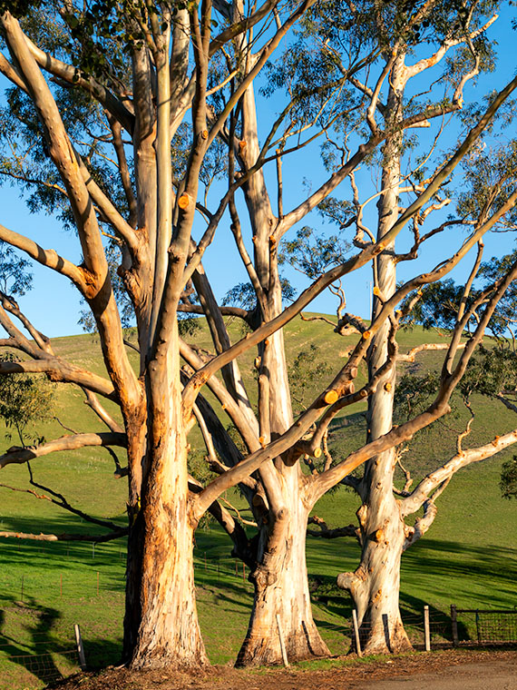
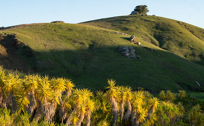
I found this trio of eucalyptus—featured in this week’s image—during my morning drive on California’s SR-46. They were only a couple of hundred yards down from the Yucca Hedge that I wrote about last week. At first, it was the light golden bark that caught my eye, but when I began processing this image, I was really pleased to find that there are only three colors in the picture; white, green, and blue (which happen to be the colors of the Sierra Leon flag, but that’s not important here). The simple colors here suggest a graphic photo. I’ll take it, even if it wasn’t planned.

I called this photo Tres Eucalyptus, and you can see a larger version on its Web Page by clicking here. Be sure to come back next week when we add another picture from our time along California’s central coast.

Until next time — jw

Yucca Hedge Picture of the Week

I’m a morning person. I wake up at dawn’s first light. If I try sleeping in, I just lay in bed with my eyes open until I give in and get up. Then, I work a few hours (writing blog posts, for example) before we have breakfast, and then it’s time for my morning nap. I haven’t needed an alarm since retirement. In fact, when I need to get up early and set a time on my clock, I wake up before it goes off. That’s the story of this week’s picture.

When Queen Anne and I traveled to California a couple of weeks ago, we only had four days, so that’s two days of driving and two days for play. Since I like photographing in the early morning and late afternoon, I planned to be shooting during those times, even if it meant getting up in the dark.

One of the subjects that I wanted to take pictures of was the Santa Lucia Range’s rolling foothills at sunrise. At home, the sun’s been coming up before 7 am, and since California goes on Daylight Savings Time (whatever for?), I should be good if I hit the road by then, so I set the alarm for 6:30.

During the night, I woke at 12:15, again at 1:37, and yet again at 3:30. By the time 5:45 came, I gave up. I got up and dressed in the dark so I wouldn’t disturb Her Majesty. I grabbed my gear and went out to the car only to remember that I forgot my mask, so I snuck back into the room to retrieve it. Getting up earlier than I expected meant that at least I had time to get a Quickie Mart cup of coffee.

Armed with a fresh hot cup of French Roast, I started driving up to the mountain pass. The amount of traffic that I encountered during the fifteen-minute drive surprised me. But then I realized that I was the one on vacation, and other people were going to work. When I reached the top, I found a safe place to park and waited for sunrise, but the sky was awfully dark still.

It took another hour for the sun to break the horizon. I completely misjudged the effects of the time change, and I didn’t take into account that Cambria is about 200 miles further west than San Diego. When the sun finally came up, I began to slowly make my way back down to the ocean stopping and shooting along the way.

Yucca Hedge - The morning sun highlights a hedge of Yucca while shadows remain on the background hills.
Yucca Hedge – The morning sun highlights a hedge of Yucca while shadows remain on the background hills.

This week’s featured image was taken at a ranch only a few miles inland of the Pacific Coast Highway. The owners had planted a hedge comprised of Yucca plants along their drive. They were in full sun while shadows played on the hills behind them. The contrast in light is interesting, and how the spikey Yucca leaves contrast with the rounded hills. The soft morning light also brings out how years of grazing cattle have created terraces in the hills. That’s good because the cattle would otherwise fall over and roll to the bottom. This terracing reminded me of New Zealand, where sheep have changed the landscape in the same way.

I called this photo Yucca Hedge, and you can see a larger version on its Web Page by clicking here. Be sure to come back next week when we add another picture from our time along California’s central coast.

Until next time — jw

Morro Bay Harbor Picture of the Week

The grass is always greener. People who live by the beach travel to the mountains for skiing. Others living in snowy climates come to the deserts to dry out and get warm. What do we desert dwellers do for a change of pace? We go to the beach of course.

After being cooped up in Arizona for the last year, when Queen Anne and I finally got our vaccine shots, we headed off to the left coast for a couple of days. It’s the anti-desert if you will. We drove an extra distance to our favorite part of California because we don’t care much for the giant megalopolis of San Die-Angeles-Barbara. There are too many people there, and they’re all out driving on the freeways.

We drove to what we call—the central coast—the Morro Bay area, and the little hamlet of Cambria. I love the place so much that two out of my three wives spent their first honeymoon there—and the third would’ve preferred it over Utah.

We spent three nights sleeping to the sound of crashing waves on the beach while a fireplace warmed the room. During the days, we put our masks on and enjoyed meals at our favorite diners and discovered new cafes (did you know that there are only four restaurants in the US with a Michelin star?). We strolled along the beach until my calves hurt, drove up to the Big Sur landslide, and peered into the windows of boutiques and galleries. Most importantly—we tasted wines at open vineyards—something we haven’t done since our 2016 Alaska trip. Let me tell you, our local Safeway gets really testy when we set up tables and start uncorking wine bottles for sampling.

But I also needed to photograph something fresh. Last month, I looked at the thumbnails on my New Work index page and realized that everything was brown. No matter how green the saguaros are, the Desert Mountains are brown. Aargh, I’m drowning in the dust. I need water. While Anne was snoring, I snuck out of the room to capture the sunrise, or after dinner, I’d plant her on a bench (she can’t walk when she’s full, so there isn’t much chance that she’d run off) while I walked around the harbor and snapped pictures as I did for this week’s featured image.

I consider Morro Bay’s town to be the southern edge of the famous drive through Big Sur. The Pacific Coast Highway (California 1) returns to the sea here and then continues up through the world’s best coastal scenery section. Here the Santa Lucia Range plunges 2,000 feet into the Pacific Ocean. The highway is temporary here because rock-slides frequently rip the road away from its precarious perch, like this year.

Morro Rock is the stump of a grand old Santa Lucia mountain that time and the sea have worn away. The rock and four neighboring smokestacks are a landmark that you can see from the mountain passes miles away. Morro Bay’s town used to be renowned for the abalone, but that delicacy has been fished out and is now protected. The commercial fishermen have moved on, so mostly private yachts are moored in the town’s harbor.

Morro Bay Harbor - private sail boats and cruisers during a calm spring sunset in Morro Bay, California.
Morro Bay Harbor – private sailboats and cruisers during a calm spring sunset in Morro Bay, California.

In this week’s featured image—Morro Bay Harbor—I tried to capture part of the local fleet using the big rock as an anchor. The setting sun made the cool, moist air glow gold. There’s an unexpected extra between the two boat groupings. In the water near the far shore is a sea otter floating on its back. Only his feet and head sticking above the water. You’ll never see it in these photos or on the Web Site. He’s there, at least I think he’s there . . . well I’m saying he’s there, and you’ll have to take my word for it.

I hope you enjoy April’s change of scenery. You can see a larger version of this week’s picture on its Web Page by clicking here, but if you want to find Waldo—the sea otter—you’ll have to buy an enlargement. Be sure to come back next week for another shot from the Big Sur coast and more fish tales.

Until next time — jw

New Water Black Mesa Picture of the Week

My first Phoenix visit was during the summer of my high school junior year. It wasn’t much of a visit. Dave and Edith—my mom’s niece and her husband lived here. They moved here from Michigan, and he hadn’t been able to find steady work as a mechanic, so my dad offered him a job maintaining his debilitated fleet of Corvair vans. They accepted and immediately packed up to move to the coast. Since I was on summer vacation and my wallet had that new-drivers-license smell, dad volunteered me to drive one of their trucks.

My father put me on an early flight out of the tiny Burbank Airport, and I arrived at an even smaller terminal where Dave met me. Parked at the curb outside was his white El Camino. I don’t remember the year, but it was loaded with toolboxes and the rest of his shop equipment. I didn’t question if it was overloaded because that was above my pay grade and comprehension at the time. I was only impressed that it had a four-on-the-floor, and it made a rumble when he started it.

We drove straight to their home, where a moving van was packed and ready for the trip. The only things that I got to see in Phoenix were the airport, the freeway, his house, and the biggest Goodyear Tire sign in the world. Even Hollywood didn’t have a sign that big and bright. I do remember that it was only mid-morning, and it was already hot. Automotive air conditioning was an exotic thing back then, so we drove with the windows down.

We didn’t spend much time at the house because everything was packed and ready. I was assigned to drive the El Camino, and he would follow in the U-Haul (or whatever brand he had rented). Both vehicles were packed to the gills, but Dave still had loads of unpacked clothes and threw them on my passenger seat before heading west on Highway 60.

Not many cars had air conditioning in 1963, but they all had wind-wings, little adjustable windows at the front of the door windows. They were useful for defogging the windshield, sucking out cigarette smoke, and when driving across the desert, they would divert the scorching wind from your face. By noon we were driving across the open desert west of Wickenburg, and my wind-wings were wide open.

Cars also had temperature gauges then because they frequently overheated. Nothing was broken; they just did that. While you drove, you watched your speed, the gas gauge, and the water temperature. You planned your stops by what the gauges said. As the day grew hotter, and the overloaded little El Camino began to run hot, and I pulled over to let Dave know. We began stopping at gas stations in each of the little towns we passed in an abundance of caution. There we would hose down the truck’s radiator and then continue on our way.

That was until we stopped at a place in the middle of nowhere. As I looked around, all I could see was the barren desert surrounded by dry, jagged mountains. The water spigot had a lock on it and a sign that read, “Water 1.00 a gallon.” That was five times the price of his gas; it was outrageous. The man behind the cash register justified the cost by saying, “Look around you, kid. Do you see any water? I have to pay to have this trucked in.” We gave in and bought a couple of gallons and slowly poured it over the gurgling radiator.

We drove another 200 miles without another incident, all the while the expensive water ate at my brain. Once we reached the cooler air in San Bernardino, the little truck behaved itself. As we drove the two-lane road crossing the lower Mohave Desert, we saw hundreds of freeway miles under construction off to the right. Interstate 10 was finished from L.A. to the Colorado River when I moved to Phoenix a decade later. In Arizona, it stopped at a place they called The Brenda Cutoff. For years I wondered who Brenda was. After moving to Congress, I realized that Brenda was the town where that infamous gas station was, and I finally put two and two together.

New Water Black Mesa - The early morning sun highlights the cliffs of Black Mesa overlooking Interstate 10 in western Arizona.
New Water Black Mesa – The early morning sun highlights Black Mesa’s cliffs overlooking Interstate 10 in western Arizona.

Last Tuesday, I pointed out the old station’s ruins and told Fred this story—well, an abridged version—as we drove back from our photo-shoot. We went there to photograph this week’s featured image of the Black Mesa in the New Water Wilderness Area. The Ramsey Mine Road approaches the wilderness, and it starts in Brenda. The lava-rock covered mesa cliffs are another of my favorite Interstate 10 landmarks. When I see them on the south side, I know that we’re almost to Quartzite, and the Colorado River is soon after. I’ve admired these formations each time I pass under them, and it’s taken me decades to figure out how to get closer. I called this shot New Water Black Mesa because there are dozens of Black Mesas throughout Arizona, so I have to start including which mesa I’m talking about.

You can see a larger version of New Water Black Mesa on its Web Page by clicking here. Next week we start a new monthly project as well as a new year. Queen Anne and I will still need to keep close to home, so come back next week and see what subject we chose.

Until next time — jw

Bakersfield – California

One must atone for their sins, I guess. I suppose that’s what we’re doing in this RV park five miles east of Bakersfield. We piddled around at the beach as long as we could. We got up late, repacked Fritz, moved boxes around and even filled up a propane tank. After Anne said goodbye to the Pacific and got in the truck, we had to leave Morro Bay behind.

Since today’s segment was only 144 miles, we arrived at 1:30. The park has over 300 spaces and was essentially empty, but the check-in people put us next to the Clampetts. They sell the place as camping in an orange grove, but the trees are too young to give any shade, and that’s what we needed when we got here.

Bakersfield Campsite
With the hot sun beating down, the first part of set-up was getting the air conditioner running.

We chose this park because . . . well, they had space for us. I also thought the heat wouldn’t be as bad in the San Joaquin Valley. The very first thing we did after parking the rig, was to plug into the power and fire up the trailer’s air conditioner. The weather page says it’s only 96°, but our little indoor/outdoor thermometer reads 104°.

After waking from a two-hour nap, I got up to take a shower. I must admit that the ones here are the absolute best we’ve seen for the last three months. There’s enough space that you can turn around in them and they have a generous size private dressing area. One thing that park owners need to learn is that there are never enough hooks in these facilities. Even in this one, there were only two, but the bench was large enough to make up for it.

We stopped here because I want to make the long trip across the desert in one day. Tomorrow we’ll get an early start. We’ll climb out of the San Joaquin over the 4000 ft Tehachapi Pass and out onto the Mohave. If all goes without incident, we should cross the Colorado River around noon. It’s at least another hour to Kingman, where we’ll stop for food. There’s a decent BBQ joint there called Rednecks. We discovered it when my parents lived there. I still can remember my dad trying to slurp down those ribs without his false teeth. I miss them.

Tehachapi Pass
The low part of the ridge between the south end of the Sierra Nevada’s on the left and the Tehachapi Mountains on the right is the 4000 ft pass that leads to the Mohave desert . . . and home.

After that, we’ll take US 93 down to Congress. We should lay eyes on the old homestead in time for cocktails on the front porch. With all the storms we’ve read about, I wonder if it’s still there. I’m looking forward to sleeping in my bed tomorrow night.

jw