Jerome, Arizona In Yavapai County

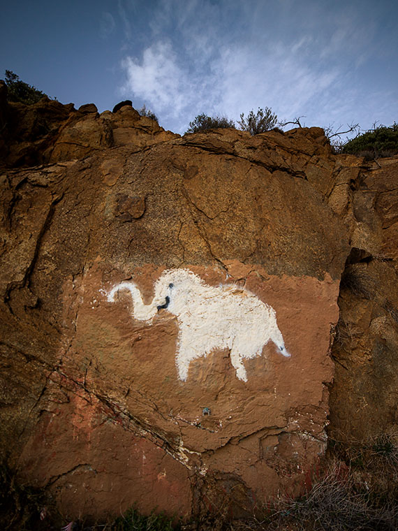
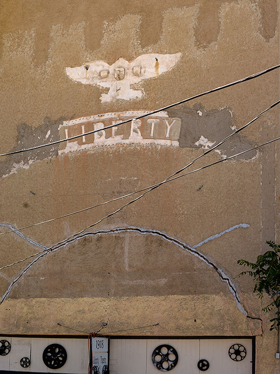
When I first moved to Arizona in 1972, I hung out at a certain Scottsdale Restaurant. It was a trendy steakhouse that had a minimalist décor of white walls with dark wood trim and original oil paintings—on loan from a gallery—decorated the walls. One painting in particular that impressed me was of an eagle emblem with a broken wing positioned over the word Liberty. The design was simple enough to be a graphic poster, but the style was photorealistic and it looked as though it could be a building sign. This was back when we all had long hair and wore bellbottom pants, so I thought it was a political statement when I first saw it.

“Oh no, that’s the Liberty Theater in Jerome,” my waitress corrected.

“Jerome, what’s that?” I asked.

“It’s the ghost town near Sedona. You’ll have to go there sometime.”

Jerome's Liberty Theater
Jerome’s Liberty Theater-My introduction to Jerome came about from a painting of this façade. Back then, part of the eagle and lettering hadn’t fallen off.

So I did, and as I wandered the streets of the old copper mine town, I felt strangely comfortable—like I had always known this place. There was something familiar about its terraced streets lined with white clapboard row-houses. Jerome reminded me of the Pittsburgh neighborhood where my great-grandmother’s—Busha—apartment house was, and where my family lived until I was in the first grade. I remember it was on Bigelow Boulevard—a wide thoroughfare that ran east from downtown up a long grade onto Pollock-Hill—the local slur for the neighborhood. Just like Jerome, laborers built our community on a mountainside on unsuitable plots and walked to work up and down endless staircases. Our apartment at Busha’s was on the second floor if you came through the front entry, but from the backyard, we were on the fourth floor of a five-story building.

Growing up in neighborhoods like these isn’t for the feeble. My preschool playmates and I would test our balance by walking along the top of the retaining wall supporting the boulevard. It was a couple of feet wide, but the sheer drops would have killed us had we fallen. Another example of peril was in our apartment’s backyard. It was paved with bricks and the neighbor’s yard was low enough that we could jump from our fence rail, over a three-foot gap, and onto the neighbor’s wood-shed roof, which—as kids always do—we double-dog dared each other to do. The jump to the roof was easy. Just climb to the top of the railing and leap onto the roof. However, the return flight required clearing the four-foot rail. I mastered the jump several times before I missed and crashed head-on into the guardrail. As gravity drug me down, I saved myself by grabbing and holding onto the railing’s bottom pipe. I hung on for dear life above the abyss and started screaming so loud that my mother could hear me four flights away. I almost lost my grip when she finally came to my rescue and as she started to pull me up, she couldn’t hold on and I became a human pachinko ball as I ricocheted between the concrete retaining wall and the shed siding. I survived the fall but not without a slight scar under my right eye that is only noticeable as a bag under my eye when I’m tired. Then, my eye has a noticeable bag under it. I don’t know what hurt worse, the bloody cut or the beating I got when my dad got home.

Flatiron Building
Flatiron Building – The Flatiron is located below downtown and it is where AZ-89 divides into two one-way streets. In the background is the House of Joy Brothel that was one of Arizona’s best places for dinner.

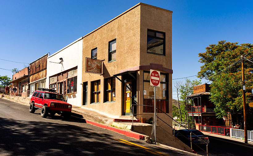
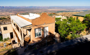
It’s been more than ten years since we’ve been to Jerome, and a couple of things struck me when Queen Anne and I visited last week. I didn’t understand at first, but there is a sense of openness now. Most of the abandoned homes have been torn down. Jerome was full of decaying houses that had crumbling foundations, sagging roofs, and signs on them that said, “Condemned – Danger – Keep Out.”  Those are gone now. The buildings that remain have been extensively restored and reinforced. There are a few new homes built on the vacant lots, and that’s good to see.

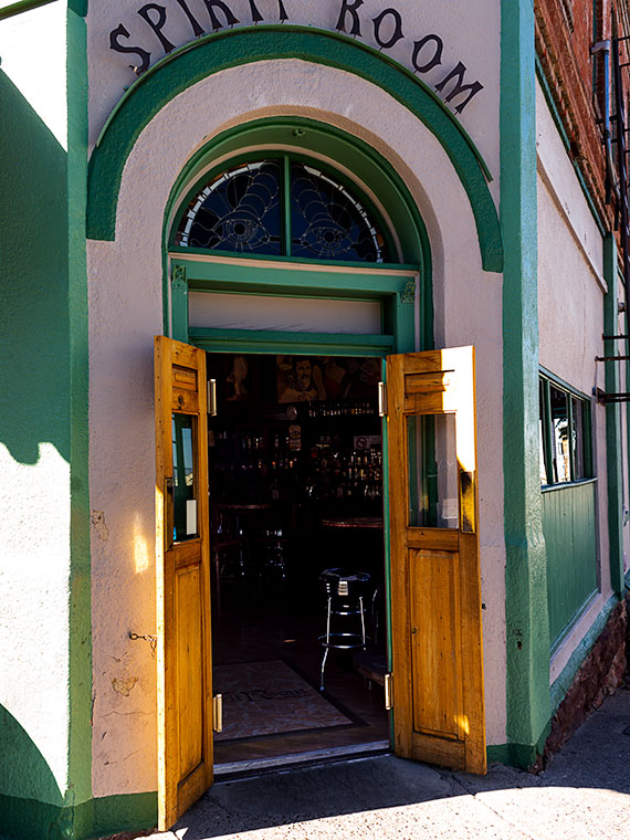
The other big change is disappointing to me. It’s the closing of the House of Joy. The historic brothel was once one of Arizona’s première restaurants but it’s closed now and the building is for sale. Eating at the House of Joy was a big occasion and a good reason for spending a night in Jerome. I’m sad that I missed the chance to dine there. Most of the current eateries are open only for breakfast and lunch, so except for the geezer cover-bands playing at the Spirit Room, evenings in town must be quiet.

Spirit Room
Spirit Room – The bar is in the Connor Hotel building. On weekends, dozens of motorcycles fill the parking spaces while middle-aged professionals are inside having a beer while listening to a geezer cover-band playing classic rock songs.

Jerome is still a great place to spend a day out of the valley. There are plenty of stores on Main Street to buy a tee-shirt, try on jewelry, admire local art, enjoy an ice cream cone, or relax with a cold beer. There are more haunted buildings than ever, and the museums and mine are worth visiting. Jerome, as always, is one of the spots that you take your eastern relatives so they’ll get an idea of Arizona’s history and geographical diversity. It’s just … the old ghost town is more refined now and not the rough and tumble kind of place I first knew.

Until next time – jw

House with a View Picture of the Week

It’s June already and our wall thermometer is reading over 100º so it’s time to shoot somewhere a little cooler. Queen Anne and I racked our brains to come up with a scene close enough for day trips, and we decided to focus on Jerome this month. It’s a ghost town close by, it is a mile high clinging to the side of Mingus Mountain, and it is cooler than here. I have personal recollections about Jerome that I plan on sharing later this week, but Sunday’s are reserved for new picture announcements, so let’s get on with it.

I’ve photographed Jerome several times over previous decades and I already have a library of the town’s familiar buildings, so on this trip, I wanted to look for details that give Jerome character—you know—the artsy pictures. I got some shots that fit that bill, but to set the stage for Jerome Month, I wanted to start with an image that would give people who have never visited the town an idea of its geographical placement, and I think this week’s featured image does that.

House with a Veiw
House with a View – Building and maintaining a home on a mountainside is a daunting task. But like this house in Jerome, the views are priceless.

I call this image House with a View and it is one of the few private residences that has survived intact. It’s a modest home that is one story on the street but has three levels at the back. It’s a brick building indicating that it was home to a family of means—like a mine manager. To me, it shows how steep the slope of the lot it’s on and how much engineering it took to keep the house from sliding into Clarkdale below. Conversely, the upside of being tethered to a mountainside is the million dollar view of the Verde Valley two-thousand feet below—and to the north, the red rocks of Sedona. Can you imagine having cocktails on that veranda while watching the sunset on the southern edge of the Colorado Plateau?

You can see a larger version of House with a View on its Web Page by clicking here. I hope you enjoy viewing my newest entry and join Queen Anne and I as we show off Jerome this month.

Until next time — jw

The Shrine Under Yavapai Skies

Ask any Arizonan about Yarnell and they’ll most likely tell you about the horrible 2013 fire that swept through the town and the 19 hotshot firefighters that lost their lives when the fire trapped them, in an open field. It’s a big deal for us and to honor those men, Arizona built the Granite Mountain Hotshots Memorial Park. Someday I hope to show that park to you, but I must first build up my stamina to be able to complete the seven-mile round trip trail over a 1200’ elevation rise. For now, I want to talk about another Yarnell attraction that’s celebrating its 79th anniversary this year; The Shrine of Saint Joseph of the Mountains. I’m guessing it’s a place that even most Arizonans haven’t heard about.

As you travel north on Yarnell’s main street lined with antique shops, it’s very easy to miss Shrine Drive, a paved road on the east side barely wide enough for passing cars. The road winds through dappled shade of scrub oaks lining Harper Canyon. The pavement only lasts a half mile, and when it turns to dirt, it’s at the Shrine parking area. As you get out of the car, the first thing you notice is how quiet it is. Even the birds whisper. You don’t see much at first, but through the trees in front of you, seated at a table is a welcoming statue of Jesus.

Praying Jesus
Praying Jesus – A statue depicting Jesus Praying is an example of Felix Lucero’s artwork at the shrine and makes a stop worthwhile.

The retreat (park, pilgrimage, or however you may interpret its purpose) was the concept of the Catholic Action League of Arizona in 1934. They worked on the plan for four years and contracted self-taught sculptor and unemployed dishwasher Felix Lucero who was living under the Congress Street Bridge in Tucson. Felix’s life is a story of its own and his other collection of work is in Tucson’s Garden of Gethsemane; now know as Felix Lucero Park. The shrine is a representation of the 14 Stations of the Cross—a ritual where Christians symbolically stop and pray at significant events that happened on Jesus’ crucifixion path. The stations at the shrine are along a stair pathway that climbs the mountainside culminating with a sculpture of Jesus on the Cross. Then you continue down the stairs past the last stations until you reach a sculpture representing the resurrection—a slab in an empty grotto draped with a shroud cloth.

Stair Path
Stair Path – The stairs leading to the Stations of the Cross are often Steep. Considering that they already start at a moderate elevation, it’s not an easy journey.

The 2013 fire swept through the shrine site. It destroyed several of the support buildings, charred the trees, and completely burned some of the wooden station crosses. The fire burned away the crucifix on the hilltop completely leaving the sculpture of Jesus floating in the air suspended by bolts welded to a metal frame. Remarkably, the ivory colored statue was not damaged or discolored.

Shrine View – There are places along the path where the canopy opens revealing beautiful views of the surrounding countryside.

I went to Catholic school for four years and that was enough to cure me of organized religion, but as an artist, I enjoy the architecture of churches and the paintings, sculptures, and stained glass within them. I think that’s why I enjoy places like this shrine. I can see the thoughtful planning, hard work, and attention to detail found here. Besides, as you near the top, the tree canopy opens, and you have wonderful views of Yarnell and the Weaver, Bradshaw, and Granite mountains.

The next time you’re traveling the back road to Prescott, I recommend you spend some time visiting The Shrine of St. Joseph in Yarnell. If nothing else, walking the stations is good exercise. Let me warn you that your starting elevation is 4700’ and the stairs are steep. It’s almost a rock scramble; bring water. You’ll enjoy the art, the views, and the serenity. There’s no charge but there is a donation box that you’re welcome to use.

Until next time — jw

The Legends of Elephant Curve Under Yavapai Skies

Elephant Rock

While testing new photo equipment last weekend, I stopped at a spot on the road that I’ve meant to stop at since we moved to Congress over two years ago. Before this weekend, I was either in a hurry, or there was too much traffic, and there was no room to get off the road. This spot is part of the famous Yarnell grade, a stretch of Arizona State Route 89 that winds through the scenic landscape. The Yarnell grade is known for its steep descent and tight curves, making it a challenging drive for many motorists. However, it also has a unique and intriguing landmark—the legendary Elephant Curve.

Elephant Curve
Elephant Curve – As shown on the USGS Topo map, Elephant Curve has earned its spot on the map, but what happened there?

It’s a real place, and the USGS Topographic map shows its name, and at that curve, there is always an elephant painted on the rocks. Once or twice a year, the Arizona Department of Transportation, or a disgruntled Democrat, will cover over the pachyderm. Someone else takes it upon themselves to draw a new version within a week. This is the fourth iteration that I’ve witnessed since we moved here.

Elephant Rock – This is the latest version of our elephant-on-the-rock. The rock art gets painted over annually but quickly reappears within a week. The version before this was in pink paint and traces of the pink area on the pachyderm’s back.Why is this elephant so important? My favorite legend is about a circus caravan traveling to Phoenix in the late 1930s. As the group descended the newly paved but steep grade, one of the trucks lost its brakes and crashed into the rock, killing Scooby—their prized elephant—and as is the tradition in Arizona, the circus troop memorialized Scooby with a painting at the crash site.

Isn’t that sad? That would explain why the elephant painting should remain a lasting memorial marker. Unfortunately, when I researched the story online and visited the Congress Library, I discovered it’s all a myth. When I asked a long-time resident, she gave me a wry smile and muttered, “That’s just a made-up story. It never happened.”

A second local legend involves a miner returning home from a night on Prescott’s Whisky Row. Reportedly, he had to swerve at that spot to avoid a giant pink elephant in the road and crashed his car head-on into the boulder. This story explains why new versions are sometimes pink instead of white.

Elephant Curve
Elephant Curve – As you descend Yarnell Hill, Elephant Curve is the tightest and slowest you’ll meet. Five days after I took this shot, another accident ripped apart this section of the Armco barrier.

Neither story is true—so I’ve been told. The true story is that some unknown local with a strong sense of humor likes to perpetuate the elephant myths. I think there must be more than one artist because each version I’ve seen has distinctive brush strokes. Now that I’m in on the joke, I can picture myself out at night painting my take on Scooby.

Until next time — jw

Yarnell Overlook Picture of the Week

For each picture of the week in this series, I normally select the best shots from the locations that I’ve written about. This week is a little different. I had to push back the scheduled image that I was going to use so I could insert a shot that I took yesterday. I intended to just shoot some test shots, but because this image fits into the current theme and because it came out better than expected, I decided to insert it into this week’s rotation. It’s called Yarnell Overlook named so because that’s where I shot it.

Yarnell Overlook  – The vista from the Yarnell Overlook takes in Fools Gulch in the foreground to Harquahala Mountain—fifty miles to the west.


I ordered a tripod part from Amazon that arrived Friday and I was anxious to put it to work, so I decided that I would ‘run up the hill’ at sunset and test it at the overlook. It was an easy place to get to and there’s little traffic there. During the day, I was concerned because of a boring cloudless sky and the winds kicked up a layer of dust making the atmosphere hazy. I resigned myself that the results would technically be OK,  so I didn’t expect more than that. As sunset approached, however, a few puffy clouds began forming near the Weavers which picked up my spirits. After dinner, I packed my gear into the car and set off for the pull-out located half-way up Yarnell Hill to conduct my test. The view from the overlook is most often hazy and the back-light from a setting sun is even worse for shooting a high detail photo.

After I processing the test, however, I think the results exceeded my expectations. Although the dust obscures the fine detail and acts, well … like fog adding some drama. I like it because of the afternoon clouds above the layer of dust. The viewpoint overlooks Fools Gulch with its working gold mine. The Stanton road that I wrote about for the last couple of weeks is just beyond the very large Parker Diary Farm that you can see in the middle-right. The last thing that is pleasing to my eye is the repeating round shapes of the boulder-covered foreground hill and Harquahala Mountain—some fifty miles away on the horizon. In case you’re curious, our house is located in a lighter patch of homes near photo’s center.

You can see a larger version of Yarnell Overlook on its Web page here. In last week’s post, I mentioned using a Like button. Fred correctly pointed out that when you follow the post links, there isn’t such a button. There are Like and Share buttons, but they are only on the blog’s homepage. To access that version, you need to first open my Webpage and click on the Blog link in the menu. That sounds like too much trouble, so I won’t bother mentioning them again. No matter which version you see, I hope you enjoy viewing my newest work.

Until next time — jw