What Happened to You Picture of the Week

Arizona has a reputation for being hot—deservedly so. Especially here in the Sonoran Desert. We frequently make the weather news for hosting the highest temperature of the day—a contest in which Gila Bend and Bullhead City are always locked in battle. For some people, any press is good press.

But as I explore the back roads of our state, I’ve come to the conclusion that the heat here had to be way worse many millennia ago. I came to this conclusion because you can’t walk more than ten steps before you step in a puddle of cooled lava—basalt (cooled quickly on the surface), andesite (mixed cooling), and granite (cooled slowly beneath the surface). Not all of this volcanic activity happened at the same time of, course. Millions of years separated eras of activity. What I’m saying is that, at times, Arizona’s ground heat far exceeded our summer temperatures. It’s probably a good thing that we’re living in this era.

The reason I’m hopped-up on geology this morning is because of the next stop that Queen Anne and I made on our one lap of Harquahala Mountain trip. Near where the Eagle Eye Road intersects with the Salome Highway, a series of volcanic hills line the south side of the road. After getting out and clambering all over them, I decided that they didn’t have star power. They’re interesting, but not that interesting. During my investigation, however, I found this poor little weird saguaro. It had eight new arms growing around it’s lopped off the top—sort of like last month’s headless version. As I got closer, I saw that the new arms were growing from other truncated arms—at least a dozen of them. It was—much like a cat eats grass to settle its stomach—like a T-Rex chomped off its top, so the saguaro put out new shoots. I remember thinking, “What the hell happened to you?” Was this caused by freezing, disease, or repeated lightning strikes? I don’t know, I’ve never seen a saguaro like this.

What Happened to You-a poor little saguaro has arms growing out of damaged arms. What caused this to happen?
What Happened to You -A poor little saguaro has arms growing out of damaged arms. What caused this to happen?

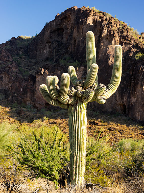
I decided to capture its portrait, and, as I framed it, the hills came in play. I lined up my shot so that the sunlit saguaro was centered on the dark rocks on the outcrop. I was so impressed with how clever I was, I also shot a dead tree and palo verde in the same way, but they didn’t come out as well. I titled this shot What Happened to You, and it’s this week’s featured image.

You can see a larger version of What Happened to You on its Web Page by clicking here. I hope you enjoy viewing it. Join us next week as we finish up our trip around the Harquahala Mountains.

Until next time — jw

BTW: Queen Anne and I wish you and your loved ones Bah Humbug—and similar salutations of the season.

Desert Broom and Windmill Picture of the Week

I’ve spent a lot of time in the desert recently. I’m less likely to run into snakes now that the weather is colder. But, there’s still a lot to be wary of when you’re out in the wild. There’s the cactus, especially the Jumping Cholla, the barbed wire, and all the illegal garbage scattered along the trail. One of the most frequent things I have to avoid is all of those cow pies. As I move, my eyes are on the ground; then, I stop to look up to get my bearings. There may not be a cow within miles, but their droppings are everywhere. I Googled it and found a state agricultural Website that said, “Grazing fields account for 73% of total land use in the state and 98% of its agricultural landholdings.” That’s a lot of free-range lands.

Desert Broom and Windmill-The picturesque windmills don't provide an efficient supply of water to cattle as water tables drop
Desert Broom and Windmill-The picturesque windmills don’t provide an efficient supply of water to cattle as water tables drop

You can tell ranching in Arizona is a big deal by the number of windmills and clumps of green trees you see as you drive down the highway. The green areas are usually associated with stock-tanks—the ranchers plow low dams on washes to retain the run-off, and the windmills pump groundwater into large metal tubs from which the herd gets a drink.

Not many of these windmills actually spin these days, regardless of how much the wind is blowing. Some of that is because the water table is dropping. There has been an ongoing drought here, and we’ve pumped enormous amounts of water out of the ground over the years. Instead of drilling the wells deeper, ranchers disable the windmills and truck water in to fill the tanks.

On our “One Lap of the Harquahala Mountains” tour that Queen Anne and I did last month, I was challenged with either shooting the mountain repeatedly, or finding interesting things that broke the monotonous sea of creosote, so when I saw this windmill off in the distance, I hiked in for a shot. When I got there, I liked the shiny metal fan against the sky, but I wasn’t impressed with its doughboy style galvanized tank. It looked as if thirsty bovine stampeded over it. Luckily there was some desert broom nearby that helped in a couple of ways. The green plants were in bloom—that’s as close as you get to fall color in the Sonoran Desert, and they camouflage the damaged tank.

I named this week’s featured image Desert Broom and Windmill. I like how the light was beginning to come in and how Harquahala Mountain shows in the background. I’m also partial to the high cirrus clouds, so I was pleased that they frame the windmill’s blades.

You can see a larger version of Desert Broom and Windmill on its Web Page by clicking here. I hope you enjoy viewing it. Join us next week as we continue along our trip around the Harquahala Mountains.

Until next time — jw

False Cave Picture of the Week

This week’s featured photo concludes our May adventure to Alamo Lake’s mud cliffs. I have another couple of detail shots that would fit nicely into this grouping, but I’ve run out of weeks this month and we have other places to go. I suppose I could put together a set of six and make up a folio like Santa Lucia Fog, or maybe I’ll go back and shoot enough images to complete a portfolio. I’ll have to think about that—what do you think?

False Cave
False Cave – This appears to be the opening of a shallow cave, but it’s not that simple.

May’s final image looks like I shot the mouth of a shallow cave with—if you squint and let your imagination go wild—a pair of cherub heads as keystones, and that’s exactly what it looks like when you approach this structure in the field. But there’s something in the photo that gives a clue that this isn’t a cave. It’s the light shining on the floor past the opening. If you crawled into the cave where that light area is, you could stand up—or you could just walk around the pile of mud to the left, and come back down the stream bed. This is actually a low arch that is torso high. If I had a model, her legs would show in the lower opening while her head and shoulders would be visible on top. It would make a unique open shower design—like you would have poolside.

In all honesty, I wasn’t creative enough to come up with that idea. The woman in spring’s photo class, whose images inspired me to visit this place, came here with a group, and one of her friends posed behind the arch. Except he was a guy and he wasn’t naked. When I walked up to this spot, I wasn’t sure it was the same because it’s so well camouflaged. If I do go back for a reshoot, I’ll need to have a model join me. What are the odds of that happening: me—a toothless old geezer—convincing an attractive woman to go with me to this barren wasteland so that we could shoot that picture? Yeah, I didn’t think so either.

You can see a larger version of False Cave on its Web page by clicking here. I hope you enjoy viewing my newest entry and join Queen Anne and I as we present new photos from a different location—this time in Yavapai County.

Until next time — jw

The Spout

This week’s featured image is the third of my Mud Cliffs series that I’ve written about for the last couple of weeks (here’s the original). In the first post, I started at the mouth of the slot canyon and last week, we got to the narrow passageway’s end—or the head. Today, we begin filling the spaces between.

The Spout
The Spout – With a low sun showing the cliff face structure, the low point turns into a waterfall during stormy weather.

I shot today’s photo, like the first, late in the day on the outbound hike—after the light turned to gold. The low sun adds a warm color to the mud and, in this case, really shows the pillar structure in the sediment. All though, I wouldn’t want to put myself in that kind of danger, I can imagine a temporary waterfall pouring over the spout between the mounds during a summer monsoon. I’ve seen it happen at Lake Powell. We were exploring a similar canyon by boat when an afternoon deluge hit us. It was a Disneyland ride with waterfalls all around. Fortunately, we weren’t hiking and need to worry about escaping a flash flood.

You can see a larger version of The Spout on its Web page by clicking here. I hope you enjoy viewing my newest entry and tag along as we look at the canyon walls for the next couple of weeks.

Until next time — jw

Mud Arch Picture of the Week

Continuing last week’s adventure to the mud cliffs at Alamo Lake, I took this week’s picture at the other end of the slot canyon. It’s not a very long hike—maybe fifteen minutes if you don’t dawdle—but I was exploring with a camera and stopped to take pictures often along the route. The reward waiting for you at the canyon’s head is this mudstone arch carved by rushing water draining from the surrounding mesa. If you hike a few yards beyond the arc, the canyon ends, and you’re on the mud flats between Date Creek and the Santa Maria River. The water is runoff from the Black Mountains in the north that has carved the canyon from the flats.

Mud Arch
Mud Arch—As a reward for your effort, a mud arch is located at the end of a short hike up the slot canyon.

Since I’m not a geologist, I can’t tell you how old the arch is, but because the surrounding soil quickly erodes and because I slept in a Holiday Inn Express once, I assume that it hasn’t been there for very long—geologically speaking—and it may soon crumble. You’ll notice that the arch’s shape isn’t smooth and rounded like the sandstone arches in Utah, which tells me it hasn’t been polished by blowing wind. That’s another clue to its relatively young age. I won’t be surprised if it disappears in less than a decade.

When I arrived at this scene, the sun was low enough that it didn’t shine onto the canyon walls, but it did add that late afternoon glow to the mound behind it and separated the arch from the background—sort of a spotlight, as it were. With streaky clouds in the sky … what more could a photographer ask for?

You can see a larger version of Mud Arch on its Web page by clicking here. I hope you enjoy viewing my newest entry and tagging along for the other canyon shots I’m revealing this month.

Until next time — jw