Saddle Mountain Silhouette: The View from Rincon Pass Picture of the Week - Sunflower Arizona

Majestic view of Mazatzal Range with Saddle Mountain silhouette at Rincon Pass.
Saddle Mountain Silhouette: A View from Rincon Pass – A picturesque landscape of the Mazatzal Range unfolds, revealing a symphony of layers and the iconic silhouette of Saddle Mountain at Rincon Pass.

Welcome back to the fourth installment of our Mazatzal Mountain tour via the Beeline Highway. With the current heat wave, our bus feels more like a scene from Romancing the Stone, filled with hot and sweaty people trying to stay cool with all the windows down. It’s so scorching outside that even chickens tied to the grill seek shade.

Of course, leave it to Queen Anne to pick the hottest week for our trip to the dentist in Algodones, Mexico. We left our comfortable haven in the Weaver Mountain foothills, where the air conditioner doesn’t run all night, only to be greeted by 115°F heat in Yuma, the lowest point in Arizona. Queen Anne’s flip-flops even melted away, forcing us to make an emergency shoe stop at a Zapata store. The trip’s highlight was the customs house with no waiting lines—small blessings in the sweltering inferno.

But enough of the heat woes; let’s escape to cooler grounds. This week’s destination is just a few miles north of our last stop, but we’ve left the Sonoran Desert behind. The newer section of the highway bypasses the shady beauty of Sycamore Creek, where there was always a respite from the sun. The creek lies on private property, and I imagine the owners are delighted to be rid of the traffic.

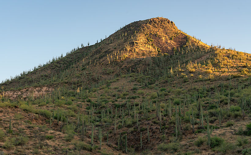
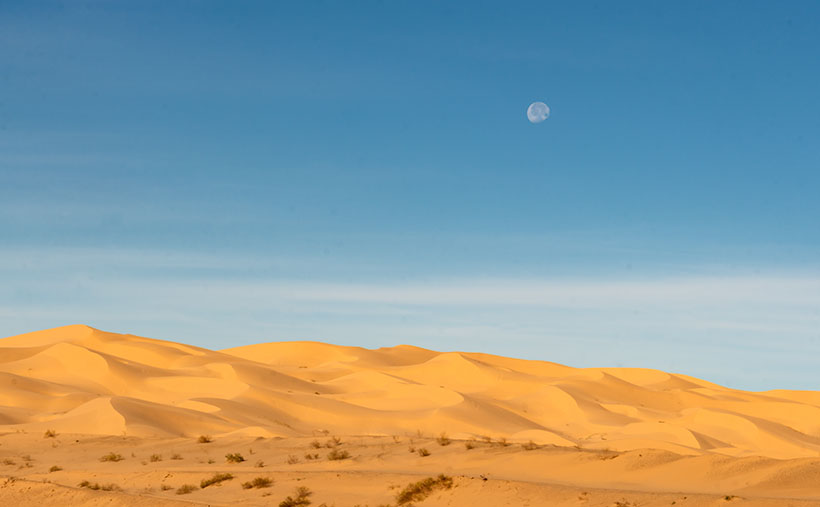
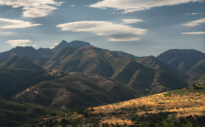
I pulled over near Iron Dike, a black rock mound, to capture this week’s featured image, Saddle Mountain Silhouette. In this shot, we gaze beyond the hilltop and the intricate jumble of mountains and canyons to Saddle Mountain—a fitting name for its distinct profile. Standing at 6529′, it doesn’t make the top ten of the Mazatzal’s tallest peaks, but its imposing presence seems to watch over the surrounding lesser hills.

Sycamore Creek flowing amidst lush greenery and tranquil waters.
Tranquil Waters: Sycamore Creek’s Verdant Beauty – Embrace the serenity of Sycamore Creek, where the gentle flow of water and vibrant greenery create a symphony of tranquility.

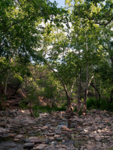
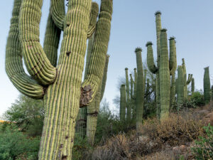
After capturing this shot, we took a refreshing detour down the old road, seeking relief from the heat under the cool canopy of sycamore leaves. Though the creek’s flow was modest, it still managed to cool the air, acting like nature’s swamp cooler.

We’re thrilled you’re along for the ride this week, and we hope to have you back next Sunday for the conclusion of our Mazatzals photo tour. Before we part ways, we invite you to visit my website and view the larger version of Saddle Mountain Silhouette by clicking this link (Jim’s Web Page) and exploring the second version on my Fine Art America site (FAA link). In the comments section below, we would love to hear how you’re coping with the heat.

Until next time,
jw

Techniques: The Advantages of Shooting in RAW

In the early days of digital photography, cameras were limited to saving images in JPEG format. However, modern digital cameras now offer the option to shoot in RAW format and JPEG, providing photographers with greater creative possibilities.

RAW files contain unprocessed and uncompressed data straight from the camera’s sensor. Unlike JPEG, which applies compression and processing, RAW files retain the original data, allowing for more flexibility during post-processing.

One of the significant advantages of shooting in RAW is its ability to provide a color depth of up to 16 bits per channel. The extra bits mean smoother gradations and a more accurate representation of colors in the final image. In contrast, JPEG images are limited to 8 bits per channel, which can lead to a loss of color information and visible banding in gradients.

RAW files are stored in an uncompressed format, ensuring that all the fine details and information captured by the camera sensor are preserved. In contrast, JPEG files are compressed, which can result in a loss of image quality and visible artifacts, especially in areas with high contrast or fine details.

RAW images can capture a more expansive color space, allowing for more vibrant and accurate colors in the final output. On the other hand, JPEG files, due to their compression and limited color depth, may exhibit color shifts and loss of detail, particularly in highly saturated or subtle color areas.

Shooting in RAW gives photographers more creative control over their images. It enables them to adjust to exposure, white balance, contrast, and other settings after you’ve taken the shot. This flexibility allows photographers to fine-tune their images to match their artistic vision and achieve the desired look.

When editing RAW images, the adjustments are non-destructive, meaning the original data remains intact. This safeguard ensures photographers can revisit their edits and make changes without compromising image quality. In contrast, directly editing a JPEG file can result in losing quality with each revision.

One of the significant benefits of shooting in RAW is the ability to convert and save images as PSD (PhotoShop) or TIFF (the Competition) files while retaining all the layers and adjustments made during editing. This feature allows photographers to maintain a master copy of their edited images, enabling future adjustments and re-editing without losing image quality.

While shooting in RAW is essential for maximum creative control and image quality, there are instances where photographers may need to save images as JPEGs. Converting the final edited image to JPEG format reduces file size and ensures compatibility for web uploads, social media sharing, or submission to specific platforms.

By shooting in RAW format, photographers have the flexibility to fully explore their creative vision and create stunning images that retain the true essence of the scene.

The Enigmatic Black Mesa: A Striking Basalt Landmark in Arizona Picture of the Week - Sunflower, Arizona

A view of Black Mesa, a pyramid-shaped basalt mountain in the Mazatzal Mountains
The Enigmatic Black Mesa – A stunning basalt pyramid rising majestically in the rugged beauty of the Mazatzal Mountains.

Welcome back to our exploration of the Mazatzal Mountains and the scenic journey along the Beeline Highway. As we continued our expedition, the changes in scenery required frequent stops for pictures. Although the scenery changes with each bend, over the years, the road has undergone its transformation—from a challenging back road to a modern highway.

My love/hate affair with the Beeline Highway began shortly after I arrived in Arizona half a century ago. At the time, I resided in south Scottsdale and had developed a passion for trout fishing. Despite my work obligations, I jumped at any opportunity to escape and make a Payson run. With a left turn at the end of McDowell Road, I could travel the picturesque route in just 90 minutes, reaching the tranquil Rim lakes where I would indulge in the serene beauty of nature and cast my fishing line.

However, weekends brought out the Beeline Highway’s dark side. State Route 87 north of Fountain Hills was a narrow, two-lane rollercoaster that could quickly diminish the joy of driving. While I found the route challenging and enjoyable under normal circumstances, the presence of holiday travelers towing trailers brought the fun to a screeching halt. A comfortable 90-minute journey became a tedious ordeal lasting several hours. These underpowered tow vehicles crawled up the grades at a snail’s pace, followed closely by a long line of frustrated drivers.

During my recent ride with Fred, I was pleasantly surprised by the Arizona Department of Transportation’s significant improvements to the Beeline Highway. The road has undergone a remarkable transformation. It now boasts four lanes for most of its length, except for a couple of long grades where they added a truck lane. The curve radius has been expanded, the shoulders widened, and other safety measures implemented, bringing the highway’s standard close to that of a freeway.

This week’s photograph was captured approximately 10 miles north of Four Peaks, featured in last week’s post. As we continue along the Beeline Highway, the elevation gradually increases, but at this particular spot, we find ourselves at the same elevation as Four Peaks Road. We haven’t gained much altitude because we recently drove over a pass at a large granite field, descending into another valley. Now, we’re beginning the ascent toward a second pass.

When I arrived at this location, the sun had just cleared the horizon, casting its soft light upon the mountaintops. It was the perfect opportunity to pull over and capture this week’s photograph of Black Mesa. Upon closer inspection of the photo, you can observe the traces of volcanism in black basalt trails running down the ravines on the mountain’s face. However, what truly caught my attention in this scene was the abundant presence of saguaro cacti on the southeast-facing slope. They outnumber the Palo Verde trees.

This is the last point on the road where saguaros thrive. Further up this grade, an imaginary frost line marks the limit for these majestic cacti to survive. As we ascend, the winters become too cold for the saguaros to endure. This splendid grove contrasts sharply with the sparse landscape and yellow grass we encountered last week. This week’s second photo was shot near where I stopped to look at a dense cluster of saguaros—the densest I’ve ever seen. It’s a testament to their resilience in this harsh desert environment, especially considering the recent wildfires that have thinned the surrounding landscape.

Close-up of a cluster of saguaro cacti in the Sonoran Desert
Desert Sentinels: Clusters of Saguaros Embracing the Sonoran Desert – A captivating ensemble of saguaros showcasing the beauty of the Sonoran Desert.

I hope you’ve enjoyed the ride so far. I appreciate your company as we explore the captivating landscapes of the Mazatzal Mountains. If you need a little break, I invite you to take some time to immerse yourself in the larger versions of The Enigmatic Black Mesa, available on my website (Black Mesa Webpage) or my Fine Art America upload (FAA Webpage). These images allow you to delve deeper into the beauty and details of this remarkable landmark. And remember, our adventure doesn’t end here. Join us next week as we explore the rugged Mazatzal Mountains on our way to Payson. There are more wonders to discover, and I look forward to sharing them with you.

Till next time
jw

Techniques: Mastering White Balance

Have you ever wondered at the wonky colors some of your photographs have? A simple answer could be the wrong White Balance adjustment. To the human eye and brain, a white sheet of paper looks white outside in the sun, in the shade, under house lights, or fluorescent bulbs. If you shoot using your camera’s raw data file, then you apply that fix in post-processing. But, if you’re shooting JPEGs or videos, the camera does the processing. Usually, cameras (and phones) have an Auto White Balance setting, but the color of a shirt, the distance of the subject, or even the wall color can easily fool it. It’s undependable.

Let’s look at it this way to keep this lesson short and sweet. The color of the sun we grew up and live with is white. If we lived on a different planet with a different sun, our brains would adjust to a new white in a few days. Scientists use the Kelvin scale as a way to measure relative color. It’s a numerical scale to measure the temperature of white light sources. A low Kelvin is warm and has a yellowish cast, so you add blue for balance. A higher Kelvin value is bluish and needs yellow for balance. For example, daylight is typically around 5500K, while tungsten lighting is around 3000K. So if you’re shooting outside, set your camera (or phone) to 5500k (or pick the sun icon), and if you’re using house lights, choose the light bulb icon (or around 3000k).

There are only a couple of exceptional instances. The first is in open shade—you’re out of the sun but under a blue sky, which are the conditions I had shooting this week’s pictures. Here, the light is being bounced off the sky, and the number needs to be higher to offset the additional blue cast. That Kelvin number is around 6500k, or the camera’s shade icon. The second exception is on cloudy days when there’s no blue sky. This is when you set the white balance to 6000k or use the camera’s cloud icon.

There is another infrequent situation that you may run into. It’s when you’re taking your eBay pictures in the garage, someone at a hospital, or a product in a retail store that has old fashion fluorescent tubes. They don’t emit red rays, so things look green. Not only do you have to adjust for the temperature, but you have to add the missing red. If your camera has a tube setting, you’re golden; otherwise, you’re alone.

If I’ve intrigued your interest and you’d like to dive deeper into white balance, numerous educational resources like this are available on YouTube (White Balance Video). You can also search YouTube for tutorials on “color correction” or “white balance” in your preferred post-processing software. There, you’ll find step-by-step guides and demonstrations to help you master this essential technique for getting natural color in your photographs.

Marble Memories: Tale of the Gadsden Hotel’s graceful stairs Picture of the Week - Douglas, Arizona

Marble Memories - Immerse yourself in the timeless elegance of the Gadsden Hotel's grand marble staircase, inviting you to step into a world of architectural splendor.
Marble Memories – Immerse yourself in the timeless elegance of the Gadsden Hotel’s grand marble staircase, inviting you to enter a world of architectural splendor.

Welcome to our wrap-up of May’s Orphan Photo Project. I hope you’ve been enjoying the show so far. This week’s episode takes us back to Cochise County and the border town of Douglas. Like several towns along our southern border, it has only a quarter of the population of its southern sibling—Agua Prieta. Unless you’re on a mission to score some cheap Kahlua, mescal, or prescription drugs, there are not many reasons to go to Douglas, but a stop at the iconic Gadsden Hotel is one of them.

Yes, I have uncovered another grand hotel from Arizona’s mining days—so indulge me. It was built at the turn of the 20th Century by mining corporations to satisfy old fat cats that traveled here to inspect the books. They couldn’t be expected to sleep in tents like the commoners they paid. These tycoons needed a place to smoke cigars and sip cognac while stuck in the wild.

The Gadsden Hotel’s architecture reflects the elegance and grandeur of the time, with its ornate facade and intricate details. It was designed to provide a luxurious experience for its guests, offering luxury accommodations, fine dining, and entertainment. It was among the first to provide in-room toilets, fresh air ventilation (yes, that sounds like open windows to me, too), and an elevator that stopped on each of its floors. Today, I’m not going to waste time gushing over this fabulous hotel; I’d rather gossip about some of its guests. That’s where all the fun is.

In the early 1900s, during the tumultuous Mexican Revolution, battles often spilled over into the border towns of Arizona. Douglas was no exception. One day, as the sounds of gunfire echoed through the streets, the guests of the Gadsden Hotel sought refuge on the rooftop to witness the spectacle. Among them was the notorious revolutionary leader, Pancho Villa.

In an audacious display of bravado, Villa rode his horse into the hotel and galloped up and down the magnificent staircase that graces the lobby. The clatter of hooves and the cheers of onlookers reverberated throughout the grand halls, creating an unforgettable moment in the hotel’s history.

Legend has it that the spirited Villa, with his characteristic wide-brimmed hat and commanding presence, left a lasting impression on the staff and guests who witnessed this daring act. It became a story that would be told and retold, forever etching Villa’s name into the annals of the Gadsden Hotel. Today’s Gadsden visitors still search for a legendary chip in the white marble.

You want to know what I think. I think Pancho got bored fighting with the Federalies in Agua Prieta and decided to take a break. He rode across the border to enjoy a frozen Margarita at the Gadsden bar—after all; it was May 5th. When the bartender tried to explain that the Margarita hadn’t been invented yet, Pancho went ballistic. He went outside and untied his horse— Siete Leguas—from the parking meter and road back inside in an attempt to trash the place. You know, rock stars. That’s what they do.

In the 1920s, famed radio evangelist Amy Semple McPherson captured the nation’s attention with her charismatic preaching and healing services. However, her life changed dramatically when she mysteriously disappeared from Los Angeles. Authorities launched a widespread search, and the public anxiously awaited any news of her whereabouts. Eventually, Amy reappeared in Douglas—of all places.

There were conflicting accounts and rumors surrounding Amy’s disappearance and reappearance. Some sources suggested that she was kidnapped and held for ransom, while others speculated that she had run off with a lover to a secluded location. According to her account, she claimed to have been abducted and held captive. My legal staff told me there is no historical evidence to put Amy inside the Gadsden, but after being released from the local hospital, where else would someone with all that wealth and fame stay—it certainly wasn’t the YWCA.

The Gadsden Hotel has welcomed several less controversial personalities throughout its history. Among them, aviator Amelia Earhart graced the hotel with her presence during her visits to Douglas in the 1930s. The iconic actor John Wayne frequented the Gadsden Hotel in Arizona. Presidents Franklin D. Roosevelt and Lyndon B. Johnson also left their mark on the hotel during their travels in the Southwest. These visits, spanning different eras, have contributed to the Gadsden’s rich history and enduring allure.

A Glimpse of Grandeur: The Gadsden Hotel's Captivating Facade - Behold the captivating exterior of the Gadsden Hotel, a timeless landmark that exudes elegance and preserves the rich history of Douglas, Arizona.
A Glimpse of Grandeur: The Gadsden Hotel’s Captivating Facade – Behold the captivating exterior of the Gadsden Hotel. This timeless landmark exudes elegance and preserves the rich history of Douglas, Arizona.

We hope you’ve enjoyed hearing the fascinating Arizona stories as we end our journey through May’s Orphan Photo Project. As usual, you can see the larger version of Marble Memories by following this link to the web page: (). As we bid farewell to the Gadsden Hotel, we invite you to join us next week when we embark on a new adventure. Until then, thank you for joining us on this journey, and Queen Anne and I can’t wait to share more with you soon.

Until next time
jw

Technique

Capturing the essence of Gadsden’s famous staircase presented a unique challenge. Instead of the typical head-on view, I wanted to emphasize the polished marble steps and the potential hazard they posed to Pancho Villa’s horse, Siete Leguas. To achieve this, I opted for a wide-angle lens and positioned myself low at the left side of the marble waterfall, shooting upwards towards the bank of stained glass windows. The dim lighting inside the Gadsden lobby required a higher ISO of 2500, and I stopped down the lens to f/6.3 to ensure everything was in focus. I captured a handheld shot at 1/15th of a second in the low light conditions. Remember to hold your breath to minimize camera shake in challenging situations like this.

Dragon Backs Picture of the Week

Dragon Backs - A pair of peaks in the Dome Rock Mountains that look like spiny back dragons.
Dragon Backs – A pair of peaks in the Dome Rock Mountains that look like spiny back dragons.

The drive between Quartzsite and Yuma on Highway US 95 has two parts. Driving in either direction, it’s thirty miles of gentle uphill grade and then downhill for the other thirty. The mid-point is at Stone Cabin (now an empty building shell), where the Border Patrol checkpoint is.

From Quartzsite, the road is dead straight, and your line of sight is limited only by the whoop-de-woos (wash dips) and the earth’s curvature. The 800-foot climb is barely noticeable, and the road is flanked on the east by the KofA Mountains (named for the King of Arizona mine), and to the west are the Dome Rock Mountains (the dome you see west of downtown Quartzsite).

The south half of the trip has a steeper grade—most of which is in the first mile, where the highway drops off a hill. The scenery changes too. There’s a different mountain range far off to the east—the Castle Dome Mountains, but you’re surrounded by the Yuma Proving Grounds, where the military plays with its new toys. Instead of a pleasant drive through the wilderness, you begin searching for things like the down-looking radar dirigible, a Bradley tank using your car for target practice, or the C-130 that just took off and climbed to 10,000 feet before troopers shove something big out of the back—I sure hope that chute opens.

Whenever Queen Anne and I travel this road, I look for these landmarks to help pass the time. I’d rather have a stimulating conversation about physics with her, but she usually has her head pressed against the headrest, her eyes closed, and her mouth open. She stays that way until one of her snorts wakes her.

On the drive home, one of the landmarks I look for is a pair of unnamed mountains in the Dome Rock Range. When I pass them, we’re nearing the Quartzsite city limits. The twin peaks look like a pair of dragons sunning themselves on a rock. I’ve often thought I’d like to get their portrait, but no matter how much map scouring I do, I’m unable to find a way to get closer—short of hiking two and a half miles across the open Mohave Desert.

The spiny back of the dragons climbs from the desert to their west-facing heads—where they watch the Colorado River flow south. As with last week’s shot, we always drive by them right after lunch. That’s the absolute worst light in the desert. I keep swearing on a stack of Ansel Adams books that I will shoot them when the light is correct, but it’s yet to happen.

On our last drug run—when last week’s photo was taken—clouds were gathering over the Dome Rock Range, so instead of a uniform blue sky, there was texture over the mountains. After I took the KofA Thunderhead shot, I walked across the highway and pointed my camera at the dragons. This time I twisted the zoom to telephoto and framed the monsoon clouds. The result is this week’s featured image, which I call Dragon Backs.

You can see a larger version of Dragon Backs on its Webpage by clicking here. Next week, I have pictures to show from a different place for show-and-tell. I hope you can take a break from your Christmas shopping and take a look. We’ll see you then.

Till next time
jw

BTW:

Flagstaff Book - A collection of photographs and musings from our summer trip to Flagstaff.
Flagstaff Book – A collection of photographs and musings from our summer trip to Flagstaff.

Oops, I Did It Again (Britney Spears song written by Richard Thompson). I published another book. This one covers all of the places we visited in and around Flagstaff. As usual, it’s available in two versions. You can see and buy the hardback on Blurb.com—which you won’t do because it’s too expensive—and the free PDF version you can download, view, and print from your computer. There are additional photos in each of the four chapters, so I’m hoping you take a look. You can get to its Web Page by clicking here.

Dune Moon Picture of the Week

When Queen Anne and I make our quarterly medical run-to-the-border, the drive is usually three-hours each way. Most of the time, we leave at dawn, see our dentist, buy prescriptions, and then come home. For me, those are long days behind the wheel; for Anne, not so much. She’s usually asleep in the passenger seat until her snoring wakes her up.

Occasionally when we have lab work done, or the customs line is three-hours long because the snow-birds have arrived, we’ll get a room in the elegant east-side Motel 6 and dine at the swanky four-star Denney’s. Our December visit was one of those occasions. Since I needed a topic for January’s posts anyway, we spent an extra night and took a circuitous route home—we’d go up to Blyth to work the Algodones Sand Dunes for this month’s project.

The great swath of sand starts about three miles south of the border outside of Los Algodones, Baja. It continues 45 miles northwest into the Coachella Valley (California’s Imperial Valley). They’re the most extensive contiguous dune system in the U.S. The dunes are also called the Imperial Dunes, Glamis Dunes, and Gordon’s Well. The name varies with location and the leisure activity you’re doing. Still, the entire system is officially named Algodones Dunes (in Spanish, it means cotton plant—the predominant crop grown on both sides of the border along the Colorado River). This week, we’ll start west of Yuma at the Mexican border—at Gordon’s Well.

Imagine it’s 1850, and you’ve traveled by wagon hundreds of miles across the scorching Sonoran Desert, forded a raging Colorado River, and finally crossed into California. You’d think your hardships are behind, but then, you’re greeted with 6 miles of Sahara-like sand to cross. With each step, you sink up to your knees. Even in 1926, when the nation’s first Ocean to Ocean highway was built (U.S. Route 80), the shifting sand was an engineering nightmare. They couldn’t simply scrape the sand away because the prevailing wind constantly covered it up again. Even today, if you’re caught in a windstorm along this section of road, you’ll risk a chance that the sand will blast the paint off your car.

Plank Road - You can see what's left of the old plank road on display at Gordon's Well.
Plank Road – You can see what’s left of the old plank road on display at Gordon’s Well.

The road builder’s solution for getting across was to build a plank road—movable wood sections on railroad-lie ties that floated on the sand’s top. It turned out to be challenging to maintain, but it drastically cut the crossing time when it was clear. Eventually, the planks were replaced with new and expensive asphalt, and eventually, it became Interstate 8. There is a section of the original plank road at Gordon’s Well on display. When you grow tired of looking at the old wood road, you can walk over to the border wall and lean on it.

Dune Moon - A waning gibbons moon setting over the Algodones Dunes west of Winterhaven, California.
Dune Moon – A waning gibbons moon sets over the Algodones Dunes west of Winterhaven, California.

As Anne and I drove west on the freeway, we spotted a waning moon setting on the dunes, so we looked for a place to stop. We’ve got stuck in these sands once before, so we were careful not to drive off the blacktop. I didn’t want to pay for another hook to come to yank us out. As you can see, we found a good spot and took this week’s picture called Dune Moon. The name could have been funnier if I had shot it during a particular summer month. Se la vie.

You can see a larger version of Dune Moon on its Web Page by clicking here. Next week we drive north up the Imperial Valley to visit the northern dune crossing. Be sure to come back and see what we found.

Until next time — jw